Spatial
Data Analysis of the Grassland Nomadic System
in Ar Horqin, Inner Mongolia, a Globally Important Agricultural Cultural Heritage Site of FAO
Wang, Z. X. Min, Q. W.
Institute
of Geographic Sciences and Natural Resources Research, Chinese Academy of Sciences,
State Key Laboratory of Resource and Environmental Information System, Beijing
100101, China
Abstract:
On May 20, 2022, ??Ar Horqin Grassland Nomadic System?? was
recognized by FAO as ??a globally important agricultural cultural heritage
system??. This brings the total number of ??globally important agricultural
cultural heritage?? to 67, including 18 in China. The heritage site of ??Ar
Horqin Grassland Nomadic System?? includes all Bayan Wendu Sumu in Ar Horqin
Banner, Chifeng city, Inner Mongolia, including 23 Gachas (villages), one national
forest reserve (Hanshan Forst), and one forest protection station, with a total
area of 3,375 km2. This dataset is the spatial data part of heritage
sites, including 7 categories: (1) spatial location and scope of heritage site:
Ar Horqin Banner; Bayan Wendu Sumu; 23 Gachas, 1 forest reserve, 1 forest
protection station; (2) Grassland nomadic system division: Winter-Spring
Pasture, Hanshan forest, Summer-Autumn Pasture; (3) Landform: 30 m-DEM and 10
m-Slope; (4) Land use: 8 classes; (5) 3 main rivers and 3 nomadic routes; (6)
NDVI: Sentinel-2 satellite in July 2018, 10-m of spatial resolution; (7)
Classification of soil erosion intensity: classification of soil erosion
intensity of forest, shrub, grassland, and bare land. The data archive format
is .kmz, .shp and .tif. This data consists of 108 data files, with a data size
of 740 MB (compressed into 2 files, 565 MB).
Keywords: globally important agricultural
cultural heritage system; Ar Horqin Banner; Bayan Wendu Sumu; grassland nomadic
system; heritage sites; soil erosion; Sentinel-2 satellite
DOI: https://doi.org/10.3974/geodb.2022.04.11
CSTR: https://cstr.escience.org.cn/CSTR:20146.14.2022.04.11
Dataset Availability Statement:
The dataset supporting this
paper was published and is accessible through the Digital Journal of Global Change Data Repository at: https://doi.org/10.3974/geodb.2022.08.07.V1
or https://cstr.escience.org.cn/CSTR:20146.11.2022.08.07.V1.
1 Introduction
Globally
Important Agricultural Heritage Systems (GIAHS) is a new type of world heritage
that FAO began to incubate in 2002; it is conceptually equivalent to the world
cultural heritage. It is a unique land use system and agricultural landscape
formed under the long-term evolution and dynamic adaptation of rural areas and
their environment. This system and landscape has rich biodiversity, and can
meet the needs of local social, economic and cultural development, and is
conducive to promoting regional sustainable development[1, 2]. To
obtain GIAHS certification, you must have outstanding characteristics in five
areas: food and livelihood security, biodiversity and ecological functions,
traditional knowledge and adaptive technology, agricultural culture, value
system and social organization, outstanding landscape, and water and soil
resource management [3, 4].
The Ministry of
Agriculture launched the excavation and protection of ??China??s important
agricultural cultural heritage?? in 2012. By November 12, 2021, 138 ??Important
Agricultural Cultural Heritage of China?? certifications have been delivered in 6 batches; As of May 20,
2022, 18 Chinese heritages have been included in the FAO list of ??Globally
Important Agricultural Cultural Heritage??.
Ar Horqin grassland
nomadic system, including the whole Bayan Wendu Sumu, Ar Horqin Banner, Chifeng
city, Inner Mongolia, covers an area of 3,375 km2. This heritage
site was included in the list of ??Important Agricultural Cultural Heritage in
China?? in 2014, and was recognized as ??Globally Important Agricultural Cultural
Heritage?? by FAO in 2022. The main body of the heritage has a semi-arid
continental climate. The interannual change of ecological conditions is large,
and it is difficult to predict the grassland productivity. Under such volatile
conditions, family-based animal husbandry (grazing) may be unable to sustain
their livelihood, it may be an inevitable choice for the local people to follow
water and grass (nomadic) over a large space and across different seasons.
However, everything
has two sides. The boundary of nomadic grassland is not very clear, and grazing
management depends on traditional customs and internal consultation[5,6].
Although the grassland nomadic system can effectively alleviate the uncertainty
brought by the changing climate, it also faces issues such as boundary disputes, large-scale fencing, and ??tragedy of
commons?? caused by the unclear property rights of the grassland[7?C9].
With the increasing popularity of the heritage site, future tourism and
production activities will bring new opportunities and challenges to the
development and protection of the heritage site, so more scientific research is
needed[10].
This dataset is the
spatial data part of the grassland nomadic system in Ar Horqin, including 7
categories, which may support the management and research of the heritage site.
2 Metadata of the Dataset
Metadata for the Spatial dataset of the globally
important agricultural heritage system??the nomadic system of the Ar Horqin
grassland in Inner Mongolia is listed in Table 1[11].
3 Spatial Data of Heritage Sites
3.1 Overview of the Heritage Site
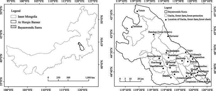
The
heritage site is located in Bayan Wendu Sumu, Ar Horqin Banner, Inner Mongolia
Autonomous Region (Figure 1a), including 23 Gachas (administrative villages), 1
forest protection station (Genpi Temple), and 1 national nature reserve
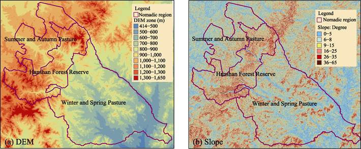
(Hanshan Forest) (Figure 1b), with a total area of 3,375 km2. Based
on the 25 units, the nomadic division of the grassland nomadic system in Ar
Horqin is Hanshan Forest in the middle, 21 Gachas and 1 forest protection station
in the south belong to Winter-Spring Pasture in the North, and Talin Hua Gacha
and Yatu Te Gacha belong to Summer-Autumn Pasture (Figure 2). In 2018, there
were 5,533 households with a total population of 15,103. By the end of June
2018, the total number of livestock on hand was 2.556 million (456,000 large
livestock and 2.047 million sheep); At the end of December, the total number of
livestock on hand was 1.792 million (305,000 large livestock and 1.443 million
sheep).
The landform of
the heritage site is characterized by open valleys and hills in the southern
Winter-Spring Pasture, low mountains and medium mountains in the central and
northern Hanshan Forest, and Inner Mongolia Plateau in the northern Summer-Autumn
Pasture. The altitude of the heritage site spans 414-1,650 m (Figure 2a).
Slope: most of
the pastures are gentle in Winter-Spring area. The altitude of Hanshan Forest
is high, and most slopes are above 16 degrees. Most pastures in Summer-Autumn
Area is above 1,000 m, but most slopes are below 25 degrees (Figure 2b).
Table 1 Metadata for the Spatial
dataset of the globally important agricultural heritage system??the nomadic
system of the Ar Horqin grassland in Inner Mongolia
|
Items
|
Description
|
|
Dataset full name
|
Spatial
dataset of the globally important agricultural heritage system??the nomadic
system of the Ar Horqin grassland in Inner Mongolia
|
|
Dataset short name
|
NomadicSystemAr
Horqin
|
|
Authors
|
Wang, Z. X. L-5255-2016, Institute of Geographic Sciences and
Natural Resources Research, CAS,wangzx@igsnrr.ac.cn
Min, Q. W. Institute of Geographic
Sciences and Natural Resources Research, CAS, minqw@igsnrr.ac.cn
|
|
Geographical region
|
Bayan Wendu Sumu, Ar Horqin Banner,
Chifeng city:119??3¢E-120??12¢E,44??32¢N-45??15¢N
|
|
Year
|
2018-2019
|
|
Spatial resolution
|
10-30 m
|
Data format
|
.shp, .tif
|
|
Data size
|
740 MB
|
|
Data files
|
7 folders: (1) location and scope of the
heritage site: Banner; Bayan Wendu Sumu; 23 Gachas, 1 Forest Reserve, 1
Forest check; (2) grassland nomadic system division: Winter-Spring Pasture,
Hanshan Forest Reserve, Summer-Autumn pasture; (3) landform: 30-m DEM and 10-m
slope; (4) land use: 8 categories; (5) 3 main rivers and 3 nomadic routes;
(6) NDVI: Sentinel-2 satellite in July 2018, 10m; (7) classification of soil
erosion intensity of forest, shrub, grassland, and bare land.
|
|
Foundation
|
Ministry of Science and Technology of P. R.
China(2021YFE0117300)
|
|
Data computing
|
ArcGIS10.8, SNAP Biophysical Processor (ESA)
|
|
Publishing and sharing platform
|
Global Change Research Data Publishing
& Repository, http://www.geodoi.ac.cn
|
|
Address
|
No. 11A, Datun Road,
Chaoyang District, Beijing 100101, China
|
|
Data sharing policy
|
Data from the Global Change Research Data
Publishing & Repository includes metadata, datasets (in the Digital Journal of Global
Change Data Repository), and publications (in the Journal of Global
Change Data & Discovery).
Data sharing
policy includes: (1) Data are openly available and can
be free downloaded via the Internet; (2) End users are encouraged to use Data
subject to citation; (3) Users, who are by definition also value-added
service providers, are welcome to redistribute Data subject to written
permission from the GCdataPR Editorial Office and the issuance of a Data
redistribution license; and (4) If Data are used to compile new
datasets, the ??ten per cent principal?? should be followed such that Data
records utilized should not surpass 10% of the new dataset contents, while
sources should be clearly noted in suitable places in the new dataset[12]
|
|
Communication
and searchable system
|
DOI, CSTR, Crossref, DCI, CSCD, CNKI, SciEngine, WDS/ISC, GEOSS
|
|
|
|
(a) Bayan Wendur Sumu
|
(b) Distribution of Gacha
|
Figure 1 Maps of Bayan Wendur and distribution of
Gacha in the heritage site
|
|
|
Figure 2 Maps
of DEM Zone and Slope of the Heritage Site
|
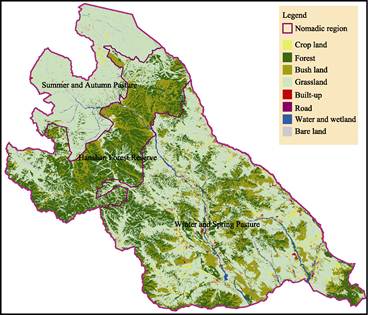
3.2 Land Use and Nomadic System of Heritage Sites
3.2.1 Land Use
According
to 2018 land use data, the total area of the heritage site is 337,523.4 ha:
grassland 51.32%, forest 26.96%, shrub 15.07% (Table 2, Figure 3). Among them,
the area of Winter-Spring Pasture in the south is the largest, 195,699.68 ha;
The area of Hanshan Forest Reserve in the middle is 84,910.68 ha; The area of
Summer-Autumn Pasture in the north is the smallest, 56,913.04 ha.
(1) Winter-Spring
Pasture: the proportion of grassland, forest and shrub forest is close to that
of the whole heritage site. Although the proportion of ??farmland?? and
??construction land?? is less than 4%, this is the most obvious feature of the
region, reflecting the relatively developed economy of Winter-Spring Pasture.
(2)
Summer-Autumn pasture: it has the advantages of wilderness and biodiversity.
First, because the land directly affected by human activities only accounts for
1.33% (0.73% of farmland, 0.17% of buildings, 0.43% of roads), while the proportion
of other landscapes with more natural characteristics is as high as 98.67%.
This makes the region have a resource that is scarce in modern
society??wilderness or nature, which is of great significance to the development
of ecotourism. This kind of wilderness has improved the diversity of ground
plants: there are nearly 300 species of herbage plants, including more than 30
kinds of medicinal plants commonly used by Mongolian people. The livestock
products produced by the Summer-Autumn Pasture with diversified herbivores have
better quality. This natural and diversified herbivorous resource, as well as
the length of feeding time, is also an important indicator for the selection of
quality mutton in Europe[13].
(3) Hanshan
Forest Reserve. As grazing is prohibited in this area, this area mainly provides
ecological services: providing water and soil conservation, and biodiversity
provenance for the north and south pastures. It provides three safe passages
for nomadic travel, ensuring grazing and rest on the way. In winter-spring
period when forage resources are scarce, appropriate grazing can be carried out
in the ??experimental area?? at the outermost periphery of the nature reserve.
The forest ecosystem of Hanshan Mountain and the Summer-Autumn Pasture have their
own characteristics and complement each other, which is a complete system for
the future development of ecotourism.
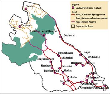
3.2.2 Main Roads and Nomadic Routes
The
roads related to nomadism in the heritage site are mainly as shown in Figure 4.
At the end of May and the head of June, 21 Gachas in Winter-Spring Pasture
start to organize cattle and sheep for transfer, set out at each Gacha
distribution center, and go north along the roads. When crossing Hanshan Forest
Reserve, it is mainly divided into three routes: east line, middle line and
west line. After entering the Summer-Autumn Pasture, continue to move to their
respective grazing areas according to the traditional conventions. In addition
to the traditional conventions, more detailed spatial zoning map is required
for the cattle and sheep of 21 Gachas (forest protection station) in Winter-Spring
Pasture to make better use of the grassland of 2 Gachas in Summer-Autumn
Pasture.
Table 2 Area and percentage of 8 land cover types
in heritage site
|
|
Winter-Spring
|
Summer -Autumn
|
Hanshan Forest
|
Total
|
|
|
Area (ha)
|
%
|
Area (ha)
|
%
|
Area (ha)
|
%
|
Area (ha)
|
%
|
|
Farmland
|
7,784.8
|
3.98
|
414.16
|
0.73
|
0.2
|
0.00
|
8,199.16
|
2.43
|
|
Forest
|
47,107.6
|
24.07
|
1,584.76
|
2.78
|
42,317.92
|
49.85
|
91,010.28
|
26.96
|
|
Shrub
|
32,770
|
16.75
|
250.72
|
0.44
|
17,836.76
|
21.01
|
50,857.48
|
15.07
|
|
Grassland
|
98,193.84
|
50.17
|
51,348.92
|
90.23
|
23,675.24
|
27.88
|
173,218
|
51.32
|
|
Built-up land
|
1,141.36
|
0.58
|
98.16
|
0.17
|
12.36
|
0.01
|
1,251.88
|
0.37
|
|
Transportation
|
920.28
|
0.47
|
242.56
|
0.43
|
62.44
|
0.07
|
1,225.28
|
0.36
|
|
Wetland
|
2,987.4
|
1.53
|
627.84
|
1.10
|
324.12
|
0.38
|
3,939.36
|
1.17
|
|
Bare land
|
4,794.4
|
2.45
|
2,345.92
|
4.12
|
681.64
|
0.80
|
7,821.96
|
2.32
|
|
Total
|
195,699.68
|
100
|
56,913.04
|
100
|
84,910.68
|
100
|
337,523.4
|
100
|
3.3 Land Degradation Assessment of Nomadic System
3.3.1 Land Degradation Assessment Method
of Nomadic System
(1)
Spatial scope of assessment: land degradation assessment is only conducted for
four land uses directly related to nomadic system, namely ??forest, shrub,
grassland, and bare land??.
(2)
Temporal scope of assessment: vegetation coverage data (here, proxied by
Sentinel-2 NDVI) is required for both water erosion assessment and wind erosion
assessment. NDVI closely follows the increase of precipitation, so it is
necessary to make a compromise: NDVI is better (not necessarily the largest),
and it is sufficient to use sunny data to synthesize the whole pastoral area.
The comparison results show that there are many clouds and fogs in August 2018,
and it is impossible to obtain enough sunny data. In September, the vegetation
coverage in the north of Hanshan Forest Reserve has decreased significantly.
July is the best month, so July 2018 is taken as the reference time (Figure 5).
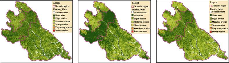
(3)
Assessment indicators and method: the Classification and Grading Standards of
Soil Erosion[14] of the Ministry of Water Resources was selected as
the quality indicator of grazing land. As the heritage site is located in the
transitional area of water erosion and wind erosion, the grazing land is first
classified into water erosion and wind erosion, and then the ??Max?? of the pixel
is represented by a more serious level.
|
|
|
|
Figure 3 Land
use of heritage sites (2019)
|
Figure 4 Main roads and nomadic routes of the
heritage
|
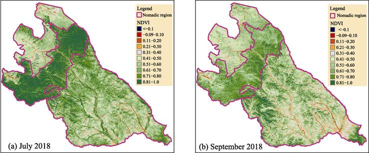
Figure 5 Maps of NDVI of heritage site in 2018 (Sentinel 2 satellite)
3.3.2 Soil Erosion Assessment Results
(1)
Water erosion
All pastures: no
erosion accounted for 32.23%, and slight erosion accounted for 50.49%,
accounting for 82.72% in total. moderate erosion is 15.86%, and severe erosion
is 1.42%. The grazing land is mainly subject to slight water erosion.
3 PastureZones:
in terms of slight and below water erosion, Hanshan Forest accounts for 94.10%,
with the highest quality. The southern Winter-Spring Pasture accounts for
80.79%, with medium quality. The proportion of summer-autumn pasture in the
north is 71.75%, which is the worst among the three pastoral areas (Figure 6a,
Table 3).
(2)
Wind erosion
In all nomadic
areas, no erosion accounts for 37.25%, and slight erosion accounts for 36.15%
(Figure 6b, Table 4).
In 3 nomadic zones:
in term of the proportion of mild and below wind erosion in the area of the
whole region, the Winter-Spring Pasture in the south is 70.26%, the Summer-Autumn
Pasture in the north is 49.18%, and the Hanshan Forest is 96.07%.
Summer-autumn
pasture: since the grassland in Summer-Autumn Pasture accounts for 90.22%, the
degree of wind erosion of the grassland can reflect the quality of pasture. The
proportion of grassland free from wind erosion is only 7.68%, the proportion of
light wind erosion is 41.47%, the proportion of moderate wind erosion is
47.60%, and the proportion of strong and above wind erosion is 3.24%.
(3)
Max soil erosion
All nomadic systems:
in all three zones, no erosion accounts for 19.94%, and slight erosion accounts
for 47.39%, both accounting for 67.33% in total. Moderate erosion accounts for
31.80%, and strong and above erosion accounts for 0.86%. Three pastoral zones:
in terms of the proportion of Slight and below soil erosion, Winter-Spring Pasture
accounts for 63.58%, Hanshan Forest accounts for 91.73%, and Summer-Autumn Pasture accounts for 42.59% (Figure 6c, Table
5).
|
|
|
(a) Water erosion
|
(b) Wind erosion
|
(c) Max SoilErosion
|
Figure 6 Maps of Land Erosion Intensity of Pasture in the Heritage Site
Table 3 Classification of water erosion
of grassland in nomadic system of heritage site (%)
|
Soil erosion
class
|
1-No
|
2-Slight
|
3-Moderate
|
4-Strong
|
5- Extremely strong
|
6-Severe
|
Total
|
|
Winter-Spring Pasture
|
30.10
|
50.70
|
17.48
|
1.44
|
0.27
|
0.02
|
100
|
|
Summer-Autumn Pasture
|
19.24
|
52.51
|
26.06
|
1.81
|
0.33
|
0.05
|
100
|
|
Hanshan Forest
|
45.38
|
48.71
|
5.63
|
0.25
|
0.02
|
0.00
|
100
|
|
Total
|
32.23
|
50.49
|
15.86
|
1.19
|
0.21
|
0.02
|
100
|
Table 4 Classification
of wind erosion of grassland in nomadic system of heritage site (%)
|
Soil Erosion
Class
|
1-No
|
2-Slight
|
3-Moderate
|
4-Strong
|
5- Extremely strong
|
6-Severe
|
Total
|
|
Winter-Spring Pasture
|
25.84
|
44.43
|
26.90
|
2.34
|
0.48
|
0.01
|
100
|
|
Summer-Autumn Pasture
|
9.73
|
39.45
|
45.95
|
3.29
|
1.42
|
0.16
|
100
|
|
Hanshan Forest
Reserve
|
80.02
|
16.05
|
3.20
|
0.37
|
0.36
|
0.01
|
100
|
|
Total
|
37.24
|
36.15
|
23.97
|
1.99
|
0.61
|
0.04
|
100
|
Summer-Autumn Pasture:
only 5.39% of the pasture land in summer-autumn pasture is not eroded, 37.20%
is slightly eroded, and 51.14% is moderately eroded. This shows that the
quality of Summer-Autumn Pasture is poor, and the pressure of grassland restoration
is great in the future.
3.4 Ground Investigation
In
order to verify the applicability of soil erosion assessment, we visited the
west line (Hundulun area) and the middle line (Tallinghua area) of the summer-autumn
pasture (Figure 7) in July 2019,
our findings are summarized below.
Table 5 Max
of water and wind soil erosion severity of pasture in nomadic system (%)
|
Soil Erosion
Class
|
1-No
|
2-Slight
|
3-Moderate
|
4-Strong
|
5- Extremely strong
|
6-Severe
|
Total
|
|
Forest
|
27.59
|
55.91
|
15.66
|
0.74
|
0.10
|
0.00
|
100
|
|
Shrub
|
5.45
|
45.50
|
43.27
|
4.87
|
0.87
|
0.04
|
100
|
|
Grassland
|
11.33
|
48.70
|
36.02
|
3.49
|
0.44
|
0.02
|
100
|
|
Bare soil
|
2.56
|
23.91
|
42.12
|
18.49
|
12.54
|
0.36
|
100
|
|
(1) Subtotal of
Winter- Spring Pasture
|
14.24
|
49.34
|
32.23
|
3.42
|
0.74
|
0.03
|
100
|
|
Forest
|
36.91
|
52.35
|
9.06
|
1.21
|
0.44
|
0.03
|
100
|
|
Shrub
|
40.65
|
52.13
|
6.88
|
0.31
|
0.02
|
0.01
|
100
|
|
Grassland
|
4.45
|
37.85
|
53.09
|
3.68
|
0.84
|
0.09
|
100
|
|
Bare soil
|
1.01
|
11.07
|
41.74
|
21.90
|
21.45
|
2.83
|
100
|
|
(2) Subtotal of
Summer- Autumn Pasture
|
5.39
|
37.20
|
51.14
|
4.36
|
1.70
|
0.21
|
100
|
|
Forest
|
48.64
|
49.66
|
1.63
|
0.06
|
0.01
|
0.00
|
100
|
|
Shrub
|
34.80
|
53.39
|
11.21
|
0.53
|
0.07
|
0.00
|
100
|
|
Grassland
|
35.92
|
48.55
|
14.13
|
1.07
|
0.32
|
0.01
|
100
|
|
Bare soil
|
10.22
|
17.74
|
23.36
|
15.01
|
33.06
|
0.61
|
100
|
|
(3) Subtotal of
Hanshan Forest Reserve
|
41.85
|
49.88
|
7.33
|
0.56
|
0.38
|
0.01
|
100
|
|
Total
|
19.94
|
47.40
|
28.97
|
2.83
|
0.81
|
0.05
|
100
|
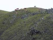
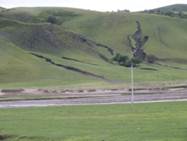
3.4.1 Slope System
The 10 m Sentinel-2 satellite data can quantitatively describe the areal
(surface) erosion of different degrees, from no erosion to severe erosion.
However, Sentinel-2 satellite failed to detect small gullies developed on the
slope with deep parent material layer. Some gullies are less than 1 m wide, yet
3-4 m
deep and more than 10 m long (Figure 7a-7d).
|
|
|
|
|
|
(a) Moderate erosion
|
(b) Severe erosion
|
(c) Gully erosion on Slope
|
(d) Gully erosion on road
|
|
|
|
|
|
|
(e) The road is cut off by
streams
|
(f) The subgrade is washed
out by streams
|
(g) The road is buried by
sand sediment
|
(h) Seasonal road
|
Figure 7 Photos of Main types of soil erosion in Summer-Autumn
Pasture
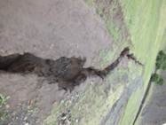
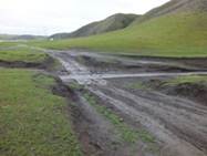
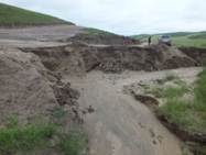
3.4.2 Land degradation in valley and flat
land systems
The
flood and sediment from the slope system converge into the valley, and the most
direct impact is on the road system: flood may wash the pavement (Figure 7d),
break the road (Figure 7e), and wash out the subgrade (Figure 7f). Sediment may
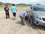
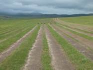
bury the road (Figure 7g). In flat areas, some self-indulgent drivers take all
good grass as roads. For example, in Hundulun Ranch, more than 20 pairs of
parallel ruts were found in grassland (Figure 7h).
4 Discussion and Conclusion
4.1 Spatial Data of Ar Horqin Grassland Nomadic
System
Ar
Horqin grassland nomadic system will face more opportunities and challenges
after it is selected as the FAO ??Global Important Agricultural Cultural Heritage
System?? in May 2022. This dataset is the spatial data part of the application
document developed in 2019, which may be used as the baseline data for future
research. In addition to the basic spatial data, the land degradation of
nomadic systems was assessed. According to the classification and grading
standards of soil erosion of the Ministry of Water Resources of China, the soil
erosion assessment was conducted on the pastures of the heritage sites using
Sentinel-2 satellite data in July 2018??
(1) The moderate
and above water erosion and wind erosion account for 17.28% and 26.61%, respectively.
The moderate and above soil erosion accounts for 32.67% of the total grazing
land.
(2) The proportion
of moderate and above soil erosion of the three pastures in the total pastures
is 36.42% in Winter-Spring Pasture, 57.41% in Summer-Autumn Pasture, and 8.27%
in Hanshan Forest Reserve. This shows that the grassland degradation in Summer-Autumn
Pasture is relatively serious.
4.2 Future Spatial Data Development
Now,
when the cattle and sheep from 23 Gachas in Winter-Spring Pasture come to the
Summer-Autumn Pasture, how to use the two Gacha pastures mainly depends on the
village rules and regulations formed over the years, and there is no clear
grassland boundary. In the future, in order to achieve the balance between
grass and livestock on a fine scale, it is necessary to develop a clearer
division of Summer-Autumn Pasture.
Author Contributions
Wang,
Z. X. was responsible for the case spatial dataset and completed the first
draft of the manuscript. Min, Q. W. refined the text.
Acknowledgements
The
author thanks Wang, B., Qian, H. Y., and Fang, X. Y. of the government of Ar
Horqin Banner for their strong support in field investigation.
Conflicts of Interest
The
authors declare no conflicts of interest.
References
[1]
Min, Q. W. Globally Important
agricultural cultural heritage??a new type of world heritage [J]. Resource Science, 2006, 28 (4): 206?C208.
[2]
Min, Q. W. Interpretation of the
selection criteria for globally important agricultural cultural heritage and
its inspiration [J]. Resource Science,
2010, 32 (6): 1022?C1025.
[3]
Min, Q. W., Zhang, Y. X.
Comparative study on agricultural cultural heritage and agricultural landscape
heritage [J]. Journal of China
Agricultural University (Social
Science Edition), 2016, 33 (2): 119?C126.
[4]
Min, Q. W. Problems and suggestions
in the declaration of China??s important agricultural cultural heritage [J]. Heritage and Conservation Research,
2019, 4(1): 8?C11.
[5]
Behnke, R. Open access and the sovereign
commons: a political ecology of pastoral land tenure [J]. Land Use Policy, 2018, 76: 708?C718.
[6]
Green, S., Cawkwell, F., Dwyer, E.
Cattle stocking rates estimated in temperate intensive grasslands with a spring
growth model derived from MODIS NDVI time-series [J]. International Journal of Applied Earth Observation and Geoinformation,
2016, 52: 166?C174.
[7]
Engler, J. O., Von Wehrden, H.
Global assessment of the non-equilibrium theory of rangelands: revisited and
refined [J]. Land Use Policy, 2018,
70: 479?C484.
[8]
Fetzela, T., Petridisa, P., Nolla,
D., et al. Reaching a
socio-ecological tipping point: overgrazing on the Greek island of Samothraki
and the role of European agricultural policies [J]. Land Use Policy, 2018, 76: 21?C28.
[9]
Zweifel, L., Meusburger, K., Alewell,
C. Spatio-temporal pattern of soil degradation in a Swiss Alpine grassland
catchment [J]. Remote Sensing of
Environment, 2019, 235: 111441. https://doi.org/10.1016/ j.rse.2019.111441.
[10]
Li, W. H. Strengthen the
scientific, professional and normative work related to China??s important agricultural
cultural heritage [J]. Leisure
Agriculture and Beautiful Countryside, 2014(8): 6?C7.
[11] Wang. Z. X., Min Q. W. Spatial dataset
of the globally important agricultural heritage system??the nomadic system of
the Ar Horqin grassland in Inner Mongolia [J/DB/OL]. Digital Journal of Global Change Data Repository, 2022. https://doi.org/10.3974/geodb.2022.08.07.V1.
https://cstr.escience.org.cn/CSTR:
20146.11.2022.08.07.V1.
[12]
GCdataPR Editorial
Office. GCdataPR data sharing policy [OL].
https://doi.org/10.3974/dp.policy.2014.05 (Updated 2017).
[13]
Erasmus, S. W., Muller, M.,
Hoffman, L. C. Authentic sheep meat in the European Union: factors influencing
and validating its unique meat quality [J]. Journal
of the Science of Food and Agriculture, 2017, 97(7): 1979.
[14] Ministry
of Water Resources of the People??s Republic of China Standard for
Classification and Grading of Soil Erosion (SL190??2007) [S]. Beijing: China
Water Resources and Hydropower Press, 2008.