Dataset
Development of Plant Species in the Lower Reaches of the Tarim River
Chen, X.
N.1,2 Gui, D. W.2,4* Yue, J.1,3 Liu, Q.1,3 Wei, G. H.5 Chen C. Q.5
1. Xinjiang
Institute of Ecology and Geography, Chinese Academy of Sciences, Urumqi 830011,
China;
2. University of
Chinese Academy of Sciences, Beijing 100049, China;
3. Cele National Station of Observation
& Research for Desert Grassland Ecosystem in Xinjiang, Cele 848300, China;
4. Xinjiang Technical Institute of Physics and Chemistry, Chinese
Academy of Sciences, Urumqi 830011, China;
5. Tarim River
Basin Management Bureau, Korla 841000, China
Abstract: The lower reaches of the Tarim River Basin serve as
a crucial ecological barrier in China??s extreme arid region, with its plant
diversity playing a key role in maintaining regional ecological balance and
addressing global climate change. This study combines field survey data with literature
data to systematically construct a plant species inventory dataset for the
lower reaches of the Tarim River. The field survey was conducted from July 30
to August 19, 2024, utilizing remote sensing and GIS technologies. A 10 m ?? 10
m plot was established in the lower reaches of the Tarim River Basin (39??25??12??N?C40??40??12??N,
87??35??24??E?C88??30??0??E).
To ensure data quality and accuracy, the research team invited plant experts to
identify plant information during the collection process. The authors
meticulously documented information on 24 families, 65 genera, and 81 species
of plants, compiling them into the Dataset of plant species of the lower
reaches of the Tarim River (2024). The dataset includes: (1) geo-locations of
the sample sites; (2) plant list and statistics of families and life
forms. The plan list is composed of family, genus, species, classification,
life form, national protection status, common names, and collection locations;
(3) plants?? photos. The dataset is archived in .shp, .xlsx, and .jpg formats,
and consists of 87 data files with data size of 1.63 GB (compressed into 4
files with 1.62 GB).
Keywords: lower Tarim River Basin; plant
diversity; dataset; field survey; extreme arid zone
DOI: https://doi.org/10.3974/geodp.2025.03.07
Dataset Availability Statement:
The dataset
supporting this paper was published and is accessible through the Digital Journal of
Global Change Data Repository at: https://doi.org/10.3974/geodb.2025.02.09.V1.
1 Introduction
The
lower reaches of the Tarim River are located at the northern edge of the
Taklamakan Desert in southern Xinjiang, one of the driest ecological regions in
the world[1]. The climate here is extremely
arid, with an annual average precipitation of less than 50 mm and evaporation
exceeding 3,000 mm, forming a unique desert ecosystem primarily composed of
desert vegetation and riparian forests[2]. Despite the harsh natural
environment, the ecosystem of the lower reaches of the Tarim River continues to
perform important ecological functions, such as regulating regional climate,
maintaining biodiversity, and conserving soil moisture[3]. Its rich
plant communities are not only a key component in maintaining the stability of
the desert ecosystem but also provide valuable ecological services to the local
society[1].
In recent years,
the combined impacts of global climate change and human activities have led to
a continuous degradation of the ecological environment in the lower reaches of
the Tarim River[4]. Rising temperatures, changes in precipitation,
and activities such as excessive water use and land expansion have severely
threatened the stability of riparian forests and wetland ecosystems. Issues
such as reduced river flow, declining groundwater levels, and vegetation
degradation have further increased ecological vulnerability, posing a severe
challenges to the sustainability of regional ecological functions[4,5].
Notably, since the launch of ecological water diversion in the lower reaches of
the Tarim River in 2000, there have been significant changes in vegetation
structure and species composition in the region. However, due to the lack of
long-term, systematic monitoring data, detailed records of species changes
remain relatively scarce. Given the ecological importance of the lower Tarim
River to both the regional environment and local livelihoods, it is
particularly necessary to gain a deeper understanding of its vegetation
diversity and dynamic change patterns. This not only helps reveal the driving
factors of ecological degradation but also provides a theoretical foundation
for developing scientifically sound ecological conservation and restoration
strategies.
Although some
scholars have conducted plant diversity studies in the Tarim River Basin[6?C8],
revealing the basic composition and distribution characteristics of the
regional vegetation, systematic datasets of plant species images are still
lacking, making it difficult to meet the urgent needs of ecological protection
and resource management. Existing studies primarily rely on scattered data with
limited coverage and long update cycles, making it difficult to accurately
reflect the dynamic changes in vegetation and its complex interactions with
environmental factors. More importantly, these datasets are insufficient to
support data-driven ecological
decision-making and management measures[9,10]. In recent years,
media reports have generally stated that there are approximately 46 plant
species in the lower reaches of the Tarim River, however, in reality, a
complete and detailed species list has long been absent. Therefore, this study
integrated field survey results with literature analysis to construct a plant diversity
dataset for the lower reaches of the Tarim River. This dataset contains rich
species distribution information, covering different vegetation types and
environmental gradients, and can provide robust data support for in-depth
ecological research.
2 Metadata of the Dataset
The
metadata of the Dataset of plant species of the lower reaches of the Tarim
River (2024)[11] is summarized in Table 1. It includes the dataset
full name, short name, authors, year of the dataset, data format, data size,
etc.
Table 1 Metadata summary of the Dataset of plant
species of the lower reaches of the Tarim River (2024)
|
Item
|
Description
|
|
Dataset full
name
|
Dataset of plant
species of the lower reaches of the Tarim River (2024)
|
|
Dataset short
name
|
PlantsList&Sites_LR_TarimRiver
|
|
Authors
|
Chen, X. N.,
Xinjiang Institute of Ecology and Geography, Chinese Academy of Sciences,
chenxiaonan231@mails.ucas.ac.cn
|
|
|
Gui, D. W.,
Xinjiang Technical Institute of Physics and Chemistry, Chinese Academy of
Sciences, guidwei@ms.xjb.ac.cn
Yue, J.,
Xinjiang Institute of Ecology and Geography, Chinese Academy of Sciences,
yuejian@ms.xjb.ac.cn
Wei, G. H.,
Tarim River Basin Management Bureau, 530748965@qq.com
|
|
Geographical
region
|
Lower Tarim
River (39??25¢12² N?C40??40¢12²N??87??35¢24² E?C88??30¢0²E)
|
|
Year
|
2024
|
|
Data format
|
.xlsx, .jpg,
.shp
|
|
Data size
|
1.63 GB
|
|
Data files
|
Geographic
location of survey sites, plant list and statistics on their families,
genera, and life forms, plant photographs
|
|
Foundations
|
National Natural
Science Foundation of China (42171042); Xinjiang Uygur Autonomous Region
(2023TSYCLJ0049)
|
|
Data publisher
|
Global Change
Research Data Publishing & Repository, htttp://www.geodoi.ac.cn
|
|
Address
|
No. 11A, Datun
Road, Chaoyang District, Beijing 100101, China
|
|
Data sharing
policy
|
(1) Data are openly available and can
be free downloaded via the Internet; (2) End users are encouraged to use Data
subject to citation; (3) Users, who are by definition also value-added
service providers, are welcome to redistribute Data subject to written
permission from the GCdataPR Editorial Office and the issuance of a Data
redistribution license; and (4) If Data are used to compile new
datasets, the ??ten percent principal?? should be followed such that Data records
utilized should not surpass 10% of the new dataset contents, while sources
should be clearly noted in suitable places in the new dataset[12]
|
|
Communication and searchable system
|
DOI, CSTR,
Crossref, DCI, CSCD, CNKI, SciEngine, WDS, GEOSS, PubScholar, CKRSC
|
3 Methods
3.1 Data Sources
3.1.1 Field Survey Data
Based on the research
objectives, vegetation type diversity, and community distribution
characteristics
in the study area, 3 vegetation sampling methods were adopted: systematic
sampling (A), transect sampling (S), and representative plot sampling (T).
Sampling plots were established in typical ecological types including riparian
zones, saline-alkali lands, wetlands, and deserts to comprehensively cover the
major vegetation communities in the lower Tarim River, with a total of 90
sampling plots (10 m ?? 10 m each) being deployed (Figure 1). GPS coordinates
were recorded for each plot, while vegetation parameters including species
composition, coverage, individual counts, and growth status were systematically
documented. Selected plots were designated as long-term monitoring sites with
periodic observations to ensure data timeliness and representativeness. The
entire sampling process was supported by remote sensing image interpretation,
GIS spatial positioning, and mapping technologies to facilitate plot selection
and spatial data annotation.
3.1.2 Literature Data
The
authors systematically reviewed recent research literature on vegetation
diversity in the lower Tarim River and typical plant communities in Xinjiang,
including academic papers[3,6?C8], datasets[9], and monographs[13,14],
with a focus on species inventories, community structure, and succession
characteristics. These references were cross-referenced, supplemented, and
validated against field survey results to enhance the comprehensiveness and
scientific rigor of the data.
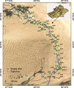
Figure 1 Distribution map of
vegetation survey sample sites in the lower Tarim River
3.2 Data Processing
The
data processing workflow consists of 3 stages: plant identification, taxonomic
correction, and data organization.
Plant
identification: Initial identification is conducted in the field using
identification software such as Xingse and Shihuajun, accompanied by
photography. Subsequent confirmation is performed using authoritative
references such as the Xinjiang Flora[13] and the Flora of China[14].
Taxonomic
correction: Verify the Latin scientific names of plants to ensure accurate
taxonomic classification, and reference the latest revisions in plant
systematics.
Data
organization: Organize survey data, remove duplicate records, and classify and
label plants based on characteristics such as their life forms.
4 Data Results
4.1 Dataset Composition
The
dataset includes the following content: (1) the geographical locations of
sampling sites; (2) a list of plant names and related information, recording
taxonomic, protection status, and life form information, including family name,
genus name, species name, taxonomic rank, life form, national protection level,
synonyms, and photography locations; (3) plant photographs for identification
and citation across disciplines. The dataset is archived in .shp, .xlsx, and
.jpg formats.
4.2 Data Results
The
vegetation survey of the lower reaches of the Tarim River was conducted from
July 30 to August 19, 2024, lasting 21 days (Figure 2), with the aim of
systematically collecting and analyzing foundational data on plant diversity in
the region. This survey employed standardized plot design and data collection
methods to comprehensively obtain key information such as species richness,
abundance, and life forms, laying a solid foundation for subsequent data
analysis.
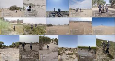
Figure 2 Photos of vegetation survey
work in the lower Tarim River
A total of 81
plant species were recorded during the survey, spanning 24 families and 65
genera. Statistical analysis of these plant families revealed that
Amaranthaceae had the highest number of species, with 15 species, accounting
for 18.5% of all plant species. Next were Fabaceae, Poaceae, and Asteraceae,
each with 9 species, accounting for 11.1% of all plant species (Figure 3). This
result indicates that Amaranthaceae plants dominate the vegetation composition
in this region, while Fabaceae, Poaceae, and Asteraceae also play a key role in
vegetation diversity.
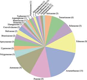
Figure 3 Classification of
plant species in the lower Tarim River
Further analysis
revealed that the plant communities in the lower reaches of the Tarim River are
relatively rich and diverse. Specifically, there are 7 species of tree plants,
primarily distributed near the riverbed and in areas with good water supply, such
as the poplar (Populus euphratica) forest belt; there are 19 species of
shrub plants, which are relatively widely distributed and mainly concentrated
along the riverbanks and in ecologically fragile areas surrounding them,
playing a role in sand fixation and water conservation; herbaceous plants are
the most abundant, with 54 species, accounting for the majority of the surveyed
plant species. They are primarily distributed in arid surfaces and river
floodplains, forming an indispensable component of the local ecosystem.
Additionally, one species of perennial vine was recorded, though in small
numbers, it plays a certain connecting role within the complex vegetation
structure (Figure 4).
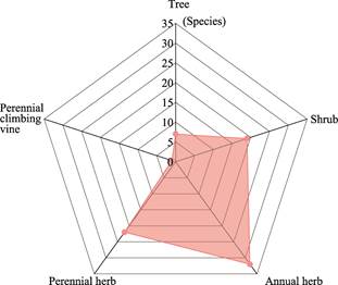
Figure 4 Classification of plant
life forms in the lower Tarim River
This diversity
reflects the unique ecological environment and complex vegetation structure of
the lower reaches of the Tarim River, demonstrating the region??s adaptability
and stability in the context of long-term natural succession and ecological
changes. Additionally, the survey identified 4 plant species under national key
protection: Populus euphratica (Poplar), Haloxylon ammodendron
(Saxaul), Glycyrrhiza inflata (Inflated Licorice), and Lycium
ruthenicum (Black Goji Berry). These protected species possess significant
ecological functions and economic value. Poplar and Saxual play important
ecological barrier roles locally, while Inflated Licorice and Black Goji Berry,
as medicinal and ecological plants, are equally significant for the restoration
and protection of the local ecosystem. Artificially cultivated Saxaul and Black
Goji Berry exhibit good growth, not only helping to improve soil structure and
prevent wind erosion, but also providing economic income for local residents.
Overall, the presence of these protected and artificially cultivated plants
further highlights the importance of ecological conservation and regional
sustainable development, demonstrating the potential and challenges of
achieving balance between nature and human activities.
5 Conclusion
This
study systematically analyzed the structure and frequency of 81 plant species
during the vegetation growth season in the lower reaches of the Tarim River,
covering 24 families and 65 genera, through literature review and field
surveys. The plant community composition was rich, with Amaranthaceae being the
most abundant, accounting for 18.5%, followed by Fabaceae, Poaceae, and
Asteraceae, each accounting for 11.1%. The distribution of trees, shrubs,
herbs, and vines reflects the ecological characteristics of the region. The
study identified 4 nationally protected plant species, including artificially
cultivated Saxaul and Black Goji Berry, which contribute to both ecological
conservation and economic development. These findings provide scientific basis
for ecological conservation and restoration and aid in evaluating the
effectiveness of ecological restoration efforts. The constructed vegetation
dataset holds significant value for ecological diversity research, climate
change assessment, educational outreach, and policy formulation. The dataset
reveals species distribution and community structure, offering new insights
into vegetation evolution and ecological functions. Future work will focus on updating and expanding the dataset to
comprehensively reflect vegetation diversity and ecological functions, thereby
advancing ecological conservation and sustainable development.
Author Contributions
Gui, D. W. proposed the theme and topic, and was
responsible for the overall design and implementation plan; Chen, X. N.
completed the field research, data analysis, and data paper; Yue, J. compiled
relevant materials on the lower Tarim River and designed the sampling route;
Liu, Q. provided guidance and made revisions to the paper; Wei, G. H. and Chen,
C. Q. were responsible for content supervision.
Acknowledgements
The authors would like to express their
special thanks to Xu, X. L. and Chen, Z. X. for their assistance in sampling
and data collection.
Conflicts of Interest
The
authors declare no conflicts of interest.
References
[1]
Zhao, Z. Y., Wang, R. H.,
Zhang, H. Z., et al. Analysis of degradation mechanism of desert
ecosystems in the lower reaches of the Tarim River [J]. Journal of Desert
Research, 2006, 26(2): 220?C225.
[2]
Sun, H. T., Chen, Y. P., Chen,
Y. N., et al. Evapotranspiration of groundwater in desert riparian
forest in the lower reaches of the Tarim River
[J]. Arid Land Research, 2020, 37(1): 116?C125.
[3]
Xu, Q., Ye, M., Xu, H. L., et
al. Effects of ecological water conveyance on plant community composition,
diversity and stability in the lower reaches of the Tarim River [J]. Chinese
Journal of Ecology, 2018, 37(9): 2603?C2610.
[4]
Li, M. Y., Deng, M. J., Ling,
H. B., et al. Evaluation of water ecological security and analysis of
driving factors in the lower reaches of the Tarim River [J]. Arid Land
Research, 2021, 38(1): 39?C47.
[5]
Hao, H. C., Hao, X. M., Cheng,
X. L., et al. Effects of water conveyance on water use efficiency of
desert riparian forest ecosystems in the lower reaches of the Tarim River [J]. Arid
Land Geography, 2021, 44(3): 691?C699.
[6]
Shi, H. B., Sun, G. L., Chen,
Y. N., et al. Population distribution patterns and coexistence
mechanisms of plants in the lower reaches of the Tarim River based on niche
differentiation [J]. Journal of West China Forestry Science, 2019,
48(6): 120?C126.
[7]
Li, J., Xu, H. L., Wang, Y. H.,
et al. Responses of plant communities of desert riparian forest in the
upper and middle reaches of the Tarim River to flooding irrigation [J]. Bulletin
of Soil and Water Conservation, 2019, 39(3): 31?C38.
[8]
Han, L. Dynamic changes of
plant communities and ecological characteristics of dominant populations in
desert riparian forest in the upper reaches of the Tarim River [D]. Urumqi:
Xinjiang University, 2014.
[9]
Liang, Z., Kezierbek, G., Han,
Y., et al. Dataset of desert plant species list in Xinjiang [J]. China
Scientific Data, 2024, 9(2): 192?C198.
[10] Tong, Y., Cao, Z., Li, M. L., et al. Composition
characteristics and distribution patterns of resource plant diversity in
Xinjiang [J]. Journal of Terrestrial Ecosystems and Conservation, 2024,
4(1): 11?C22+34.
[11]
Chen,
X. N., Gui, D. W., Yue, J., et al. Dataset of plant species of the lower
reaches of the Tarim River (2024) [J/DB/OL]. Digital
Journal of Global Change Data Repository, 2025.
https://doi.org/10.3974/geodb.2025.02.09.V1.
[12] GCdataPR Editorial Office. GCdataPR data sharing policy [OL].
https://doi.org/10.3974/dp.policy.2014.05 (Updated 2017).
[13] Editorial Committee of Flora of Xinjiang. Flora of Xinjiang: Volumes
1?C10 [M]. Urumqi: Xinjiang People??s Publishing House, 1993?C2011.
[14] Editorial Committee of Flora of China, Institute of Botany, Chinese
Academy of Sciences. Flora of China: Volumes 1?C80 [M]. Beijing: Science Press,
1959?C2004.