Monitoring Dataset Development of Waterbirds in the Late
Breeding Season in the Qinghai Section of the Yellow River Basin (2024)
Dong, Y. G.1,2 Cui, Q. C.1,2 Ji, H. C.3 Zhang, G. M.4 Tang, X. Y.5 Zhong, Y. T.1 Tang, B. Y.1 Yang, F.6 Zhao, H.7 Duo, W. K.6 LI, G. G.8 Sun, N.8 Shen, M. H.1 Wang, X. L.9 Wang, A. Z.1 Wang, W.1*
1. State Key
Laboratory of Plateau Ecology and Agriculture, Qinghai University, Xining
810016, China;
2. College of
Eco-Environmental Engineering, Qinghai University, Xining 810016, China;
3. Qinghai
Wetland Protection Center, Xining 810008, China;
4. Qinghai
Clover Ecological Technology Service Co., Ltd., Xining 810007, China;
5. College of
Agriculture and Animal Husbandry, Qinghai University, Xining 810016, China;
6. Qinghai
Duomei Ecological Environmental Protection Technology Co., Ltd., Xining 810003,
China;
7. Qinghai
Yilin Forestry Planning and Design Co., Ltd., Xining 810007, China;
8. College of
Life Sciences, Qinghai Normal University, Xining 810016, China;
9. Qinghai Forestry Engineering
Consulting Co., Ltd., Xining 810003, China
Abstract: The Yellow River
Basin in Qinghai covers area of northeastern edge of the Qinghai- Xizang
Plateau, its wetland ecosystem is vital for waterbirds during breeding,
stopover, and wintering. In August 2024, 335 sites across 21 units in the basin
were monitored using the plot method to obtain the monitoring dataset of
waterbirds in the late breeding season in the Qinghai Section of the Yellow
River Basin (2024). The dataset includes: (1) locations of sample sites and
general information of 21 monitoring units; (2) species composition and numbers
in each unit; (3) species composition and dominant species across the basin;
(4) location, elevation, and habitat type of 335 sites; (5) waterbird species
list for the basin; (6) diversity indices of waterbird communities in each unit
and basin section, etc. The dataset is archived in .xlsx, .shp, .jpg and .doc
formats, and consists of 19 data files with data size of 36.2 MB (compressed
into one file with 35.0 MB).
Keywords: Yellow River Basin; Qinghai
Province; late breeding season; waterbird; 2024
DOI: https://doi.org/10.3974/geodp.2025.03.05
Dataset Availability Statement:
The dataset
supporting this paper was published and is accessible through the Digital Journal of
Global Change Data Repository at: https://doi.org/10.3974/geodb.2025.03.08.V1.
1 Introduction
The Yellow River Basin in Qinghai
Province, which is located within the northeastern margin of the Qinghai-Xizang
Plateau, constitutes a critical node in the East Asia?C Australasia and Central
Asia flyways for migratory birds. Its unique wetland ecosystem provides
essential habitats for waterbirds to breed, rest, and overwinter[1,2].
As a global biodiversity hotspot, this basin not only exhibits distinctive
ecological functions but also serves as an important indicator system for
evaluating regional environmental health. Waterbirds, as indicator species of
wetland ecosystems, demonstrate population dynamics that directly reflect the
health status of the regional ecological environment and the effects of climate
change. These dynamics correlate positively with the quality of the habitat
quality and the integrity of the food chain, thereby possessing significant
ecological monitoring value[3,4].
The breeding period, a core phase in the annual life cycle of birds,
occurs during the most favorable season for chick growth due to abundant food
availability. It encompasses behaviors such as courtship, nest-site selection,
egg-laying and hatching, and chick rearing[5,6]. The post-breeding
period is crucial for juveniles to complete feathering and achieve independent
survival, with its population dynamics directly reflecting the relationship
between breeding success and habitat carrying capacity. Previous research has
indicated that the population size during the post-breeding period and the
survival rate of juveniles represent a key window for evaluating breeding
outcomes[7]. Despite research being conducted on the ecological
requirements of waterbirds during migration and overwintering periods, there
are insufficient systematic studies on the post-breeding period, particularly
the juvenile dispersal stage in August. Investigations during this period can
not only reveal the mechanisms of population replenishment among waterbirds but
also hold significant implications for improving the conservation of breeding
bird communities. In this regard, the dataset described in this study, which
was developed based on the monitoring data of post-breeding waterbirds in the
Yellow River Basin of Qinghai Province in August 2024, aims to clarify the
population structure, distribution characteristics, and their association with
environmental factors during this phase. It also aims to provide a scientific
basis for improving the wetland protection network within the Yellow River
Basin and formulating adaptive management strategies.
2 Metadata of the Dataset
The metadata of the Monitoring dataset of waterbirds
in the late breeding season in the Qinghai section of the Yellow River Basin
(2024)[8] is summarized in Table 1. It includes the dataset full
name, short name, authors, year of the dataset, data format, data size, data
files, etc.
3 Methods
(1) Division
of survey units: Due to the large area and numerous watersheds involved in the
Yellow River Basin within Qinghai Province, this study delineated 21 survey
units for monitoring post-breeding waterbirds based on wetland types,
distribution characteristics, and behavioral traits of waterbirds, as well as
practical considerations regarding human resources, material capacity, and financial conditions (Figure 1). These units
are located across 12 counties (cities) in 6 prefectures (municipalities). The
selected survey units encompass a wide variety of wetland habitat types,
including rivers, lakes, and marshes, and represent multiple conservation
management categories, viz., 2 internationally important wetlands, 10 national wetland parks, 1 small
wetland, 2 reservoir areas, 2 reservoirs, 2 protected
Table 1 Metadata summary
of the Monitoring dataset of waterbirds in the late breeding season in the
Qinghai section of the Yellow River Basin (2024)
|
Items
|
Description
|
|
Dataset full name
|
Monitoring dataset of waterbirds in the late breeding
season in the Qinghai section of the Yellow River Basin (2024)
|
|
Dataset short name
|
WaterbirdsQinghaiYellowRiverBasin2024
|
|
Authors
|
Dong, Y. G., State Key Laboratory of Plateau Ecology
and Agriculture, Qinghai University, dyg0516@126.com
Cui, Q. C., State Key Laboratory of Plateau Ecology and Agriculture, Qinghai
University, cqc5614@163.com
Ji, H. C., Qinghai Wetland
Protection Center, 1522730373@qq.com
Zhang, G. M., Qinghai Clover
Ecological Technology Service Co., Ltd., 1259706000@qq.com
Tang, X. Y., College of Agriculture and Animal Husbandry, Qinghai University,
maybefogot@163.com
Zhong, Y. T., State Key Laboratory of Plateau Ecology and Agriculture,
Qinghai University, 384043309@qq.com
Tang, B. Y., State Key Laboratory of Plateau Ecology and Agriculture, Qinghai
University, 3028746390@qq.com
Yang, F., Qinghai Duomei Ecological Environmental Protection Technology Co.,
Ltd., 13119768655@163.com
Zhao, H., Qinghai Yilin Forestry Planning and Design Co., Ltd., 1559068384@qq.com
|
|
|
Duo, W. K., Qinghai Duomei Ecological Environmental
Protection Technology Co., Ltd., 1738197848@qq.com
Li, G. G., College of Life Sciences, Qinghai Normal University, qhnulgg@126.com
Sun, N., College of Life Sciences, Qinghai Normal University, applewolf@126.com
Shen, M. H., State Key Laboratory of Plateau Ecology and Agriculture, Qinghai
University., 709652141@qq.com
Wang, X. L., Qinghai Forestry Engineering Consulting Co., Ltd., 15597006137@163.com
Wang, A. Z., State Key Laboratory of Plateau Ecology and Agriculture, Qinghai
University, 154633018@qq.com
Wang, W., State Key Laboratory of Plateau Ecology and Agriculture, Qinghai
University, 007cell @126.com
|
|
Geographical region
|
Yellow River Basin in Qinghai Province
|
|
Year
|
2024
|
|
Data format
|
.xlsx, .shp, .jpg, .doc
|
|
|
|
Data size
|
36.2 MB
|
|
|
|
Data files
|
Geographical locations of survey sites and basic
information of 21 monitoring units; species composition and numbers of
waterbirds in each unit; species composition and dominant species of
waterbirds across the entire basin; basic information of 335 monitoring
sites; waterbird checklist during the post-breeding period in the Qinghai
section of the Yellow River Basin; and biodiversity indices of waterbird
communities in each unit and across different river segments
|
|
Foundation
|
Qinghai
Province (QHJY-2024-07-001)
|
|
Data publisher
|
Global Change
Research Data Publishing & Repository, http://www.geodoi.ac.cn
|
|
Address
|
No. 11A, Datun Road, Chaoyang District,
Beijing 100101, China
|
|
Data sharing
policy
|
(1) Data are openly available and
can be free downloaded via the Internet; (2) End users are encouraged to use Data
subject to citation; (3) Users, who are by definition also value-added
service providers, are welcome to redistribute Data subject to
written permission from the GCdataPR Editorial Office and the issuance of a Data
redistribution license; and (4) If Data are used to
compile new datasets, the ??ten percent principal?? should be followed such
that Data records utilized should not surpass 10% of the new
dataset contents, while sources should be clearly noted in suitable places in
the new dataset[9]
|
|
Communication and searchable
system
|
DOI, CSTR, Crossref, DCI,
CSCD, CNKI, SciEngine, WDS, GEOSS, PubScholar, CKRSC
|
areas,
and 2 additional waterbird aggregation sites.
To facilitate spatial analysis and
comparison, the 21 survey units were divided into upper, middle, and lower
reaches of the Yellow River in Qinghai Province, based on the flow
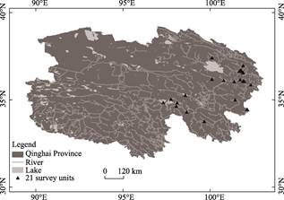
Figure 1 Distribution map of waterbird
survey units in the Yellow River Basin within Qinghai Province
direction
and elevation gradients of the river across the units. The upper reach
comprises 10 monitoring units at elevations between 3,000 and 4,000 m,
including Gyaring Lake, Eling Lake, Xingxinghai, Lake Jiangmeng, Lake
Gangnagema, Maduo Dongge Cuona Lake National Wetland Park, Dari Yellow River
National Wetland Park, Zeku Zequ National Wetland Park, Taoheyuan National
Wetland Park, and Gangcha Shaliu River National Wetland Park. The middle reach
includes 4 units at elevations between 2,000 and 3,000 m, viz., Lake Gengga,
Longyangxia Reservoir, Huzhu Nanmenxia National Wetland Park, and Gui De Huangheqing
National Wetland Park. The lower reach encompasses 7 units at elevations
approximately between 1,800 and 2,000 m, including Xining Huangshui National
Wetland Park (Ninghu), Xining Huangshui National Wetland Park (Huangshui),
Xining Huangshui National Wetland Park (Beichuan River), Hualong Yashiga Town
Micro Wetland, Suzhi Reservoir Area, Kangyang Reservoir Area, and Lijiaxia
Reservoir.
(2) Survey species
definition, survey methods, and selection of observation plots: According to the definition of waterbirds provided
by the Ramsar Convention on Wetlands?? i.e., birds that are ecologically
dependent on wetlands and exhibit morphological and behavioral adaptations to
such habitats??the waterbirds in this study were restricted to aquatic birds
(divers and swimming feeders) and waders (shorebirds) based on ecological
classification. Different survey methods (including direct counting and plot-based
counting) were applied according to the flocking behavior of waterbirds and
differences in their habitats. Observation plots within each survey unit were
determined based on topographic features, habitat type, and spatial
distribution of waterbirds.
(3) Classification
and evaluation system of disturbance types: Disturbance types were categorized
into the following 6 types: grazing, fishing, river regulation, tourism
development, road construction, and water pollution. Disturbance intensity was
classified into 3 levels??moderate, weak, and none??according to the degree of
influence on habitat structure, wetland status, and waterbird survival and
reproduction. Moderate disturbance refers to situations where habitat is
affected, a portion of the wetland has disappeared, but vegetation can recover
after the disturbance ceases, and despite slight impact on bird breeding,
reproduction can occur. Weak disturbance indicates that the habitat is slightly
disturbed, wetland vegetation remains largely intact, and the impact on
waterbird survival and reproduction is minimal. No disturbance implies that the
habitat remains undisturbed, wetland vegetation maintains its original state,
and waterbird breeding and survival are unaffected. Figure 2 shows the
technical roadmap of the data development methodology.
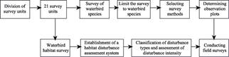
Figure 2
Flowchart of the dataset development
4 Data Results
4.1 Dataset Composition
This
dataset monitors postbreeding waterbirds across 21 units in the Yellow River
Basin within Qinghai Province. It includes: (1) geographic locations of survey
sites and basic information on the 21 monitoring units, (2) species composition
and numbers of waterbirds in each unit, (3) species composition and dominant
species of waterbirds throughout the entire Yellow River Basin in Qinghai, (4)
basic information, including latitude, longitude, altitude, and habitat types,
for 335 monitoring sites, (5) checklist of postbreeding waterbirds in the
Yellow River Basin in Qinghai, (6) diversity indices of waterbird communities
across different units and river segments, and (7) photographs of some
waterbird species. The dataset is archived in .xlsx, .shp, .jpg, and .doc
formats.
4.2 Data Results
4.2.1 Species Composition
Monitoring
records from August 2024 documented 65 species of waterbirds belonging to 7
orders and 14 families, with a total count of 24,250 individuals. In terms of
species diversity, Anatidae of Anseriformes accounted for 19 species,
Podicipedidae of Podicipediformes accounted for 4 species, Rallidae of
Gruiformes accounted for 2 species, Gruidae of Gruiformes accounted for 1
species, Ciconiidae of Ciconiiformes accounted for 1 species, Threskiornithidae
of Pelecaniformes accounted for 1 species, Ardeidae of Pelecaniformes accounted
for 4 species, Phalacrocoracidae of Suliformes accounted for 1 species, Ibidorhynchidae
of Charadriiformes accounted for 1 species, Recurvirostridae of Charadriiformes
accounted for 2 species, Charadriidae of Charadriiformes accounted for 7
species, Scolopacidae of Charadriiformes accounted for 16 species, Glareolidae
of Charadriiformes accounted for 1 species, and Laridae of Charadriiformes
accounted for 5 species. Among these, Charadriiformes had the highest
proportion at 49.2% (32 species), followed by Anseriformes at 29.2% (19
species). In terms of numbers, the top 10 most abundant waterbird species were the
Bar-headed Goose (Anser indicus) (6,681 individuals), Ruddy Shelduck (Tadorna
ferruginea) (6,031 individuals), Great Crested Grebe (Podiceps cristatus)
(2,442 individuals), Brown-headed Gull (Chroicocephalus brunnicephalus)
(1,581 individuals), Great Cormorant (Phalacrocorax carbo) (1,435
individuals), Eurasian Coot (Fulica atra) (833 individuals), Common
Redshank (Tringa totanus) (527 individuals), Common Tern (Sterna
hirundo) (476 individuals), Eastern Spot-billed Duck (Anas zonorhyncha)
(421 individuals), and Pallas??s Gull (Ichthyaetus ichthyaetus) (410
individuals). 5 species, viz., the Bar-headed
Goose, Ruddy Shelduck, Great Crested Grebe, Brown-headed Gull, and Great
Cormorant, exceeded 1,000 individuals.
The species
composition and numbers of waterbirds recorded in each of the 21 survey units
are presented in Table 2. Among the 21 survey units, 3 units, viz., Eling Lake
(3,898), Lake Gengga (3,870), and Lake Gangnagema (2,699), had the highest
number of waterbirds, and another 3 units, viz., Lake Gengga (55 species),
Longyangxia Reservoir (23 species), and Gangcha Shaliu River National Wetland Park
(23 species), showed the highest species diversity. Regarding conservation
status, there were 2 nationally protected species under Class I, viz., the
Black-necked Crane (Grus nigricollis) and Black Stork (Ciconia nigra),
and 7 nationally protected species under Class II, including the Mute Swan (Cygnus
olor), Whooper Swan (Cygnus cygnus), and Horned Grebe (Podiceps
auritus). According to the International Union for Conservation of Nature
Red List, 56 species were classified as Least Concern (LC); 2 species were
classified as Vulnerable (VU), viz., the Common Pochard (Aythya ferina)
and Horned Grebe; and 7 species were classified as Near Threatened, including
the Ferruginous duck (Aythya nyroca), Black-necked Crane, and Northern Lapwing
(Vanellus vanellus), etc.
Table 2 Species composition
in 21 survey units
|
Survey unit
|
Order
|
Family
|
Species
|
Total number
of birds
|
|
Gyaring Lake
|
5
|
7
|
12
|
2,183
|
|
Eling Lake
|
5
|
7
|
13
|
3,898
|
|
Xingxinghai
|
5
|
6
|
15
|
1,735
|
|
Lake Jiangmeng
|
3
|
4
|
6
|
273
|
|
Lake Gangnagema
|
5
|
6
|
14
|
2,699
|
|
Maduo Dongge Cuona Lake National Wetland Park
|
5
|
8
|
14
|
3,173
|
|
Dari
Yellow River National Wetland Park
|
3
|
6
|
9
|
85
|
|
Lake Gengga
|
4
|
12
|
55
|
3,870
|
|
Longyangxia Reservoir
|
5
|
8
|
23
|
1,720
|
|
Gui De Huangheqing National Wetland Park
|
6
|
6
|
14
|
193
|
|
Gangcha Shaliu River National Wetland Park
|
5
|
10
|
23
|
1,909
|
|
Xining Huangshui National Wetland Park (Ninghu)
|
5
|
5
|
10
|
187
|
|
Xining Huangshui National Wetland Park (Huangshui)
|
3
|
3
|
5
|
356
|
|
Xining Huangshui National Wetland Park (Beichuan
River)
|
4
|
4
|
5
|
581
|
|
Huzhu Nanmenxia National Wetland Park
|
4
|
7
|
11
|
103
|
|
Hualong Yashiga Town Micro Wetland
|
3
|
3
|
5
|
36
|
|
Suzhi Reservoir Area
|
4
|
5
|
12
|
206
|
|
Kangyang Reservoir Area
|
4
|
7
|
16
|
240
|
|
Lijiaxia Reservoir
|
4
|
6
|
14
|
207
|
|
Zeku Zequ National Wetland Park
|
4
|
5
|
13
|
320
|
|
Taoheyuan National Wetland Park
|
5
|
8
|
15
|
276
|
|
Total
|
7
|
14
|
65
|
24,250
|
4.2.2 Analysis of
Waterbird Ecological Indices in Different Units
Table
3 shows the waterbird community diversity, analyzed using diversity indices
(Shannon, Pielou, and Simpson)[10?C12], across the 21 survey units in
the Yellow River Basin within Qinghai Province. The structure of waterbird
communities exhibited certain spatial heterogeneity among different units. The
highest Shannon diversity indices were observed in Lake Gengga (2.55) and Gui De
Huangheqing National Wetland Park (2.20), indicating that these two survey
units have relatively high species diversity. However, some regions, such as
Gui De Huangheqing National Wetland Park and Huzhu Nanmenxia National Wetland
Park, exhibited relatively high Shannon diversity indices and Pielou evenness
indices but lower Simpson indices, which suggest a degree of dominance by
certain species in these areas.
Table 3 Waterbird community
diversity indices in 21 survey units
|
Survey unit
|
Shannon
|
Pielou
|
Simpson
|
|
Gyaring Lake
|
1.48
|
0.59
|
0.37
|
|
Eling Lake
|
1.52
|
0.57
|
0.28
|
|
Xingxinghai
|
2.15
|
0.79
|
0.14
|
|
Lake Jiangmeng
|
1.02
|
0.57
|
0.47
|
|
Lake Gangnagema
|
1.59
|
0.60
|
0.30
|
|
Maduo Dongge Cuona Lake National Wetland Park
|
1.45
|
0.55
|
0.29
|
|
Dari
Yellow River National Wetland Park
|
1.79
|
0.81
|
0.21
|
|
Lake Gengga
|
2.55
|
0.64
|
0.15
|
|
Longyangxia Reservoir
|
1.51
|
0.48
|
0.35
|
|
Gui De Huangheqing National Wetland Park
|
2.20
|
0.83
|
0.13
|
|
Gangcha Shaliu River National Wetland Park
|
1.68
|
0.54
|
0.32
|
|
Xining Huangshui National Wetland Park (Ninghu)
|
1.47
|
0.67
|
0.28
|
|
Xining Huangshui National Wetland Park (Huangshui)
|
0.76
|
0.47
|
0.58
|
|
Xining Huangshui National Wetland Park (Beichuan
River)
|
1.08
|
0.67
|
0.40
|
|
Huzhu Nanmenxia National Wetland Park
|
2.00
|
0.84
|
0.16
|
|
Hualong Yashiga Town Micro Wetland
|
1.13
|
0.70
|
0.36
|
|
Suzhi Reservoir Area
|
1.78
|
0.74
|
0.25
|
|
Kangyang Reservoir Area
|
2.17
|
0.78
|
0.17
|
|
Lijiaxia Reservoir
|
2.08
|
0.79
|
0.16
|
|
Zeku Zequ National Wetland Park
|
1.53
|
0.60
|
0.36
|
|
Taoheyuan National Wetland Park
|
1.23
|
0.45
|
0.52
|
4.2.3 Analysis of
Waterbird Ecological Indices Across River Segments
Based
on the flow direction and elevation gradients of the 21 survey units, the
Yellow River Basin in Qinghai Province was divided into 3 river segments??upper,
middle, and lower reaches??for the analysis of waterbird ecological indices. As
shown in Table 4, the Shannon diversity index for the middle reach was 2.71,
which was significantly higher than those of the upper reach (1.91) and lower
reach (1.90), indicating that the middle reach has a higher species richness
and overall diversity. Similarly, the Pielou evenness index was also higher in
the middle reach than in the upper and lower reaches, suggesting a more
balanced relative abundance among species in this segment.
Table 4 Waterbird community diversity indices in different river
segments
|
Watershed
|
Shannon
|
Pielou
|
Simpson
|
|
Upper segment of the Qinghai Watershed in the
Yellow River
|
1.91
|
0.55
|
0.22
|
|
Middle segment of the Qinghai Watershed in the
Yellow River
|
2.71
|
0.65
|
0.13
|
|
Lower segment of the Qinghai Watershed in the
Yellow River
|
1.90
|
0.62
|
0.22
|
4.2.4 Evaluation of
Dominant Species
The
Berger-Parker dominance index (I)[13] was used to determine dominant
bird species, where I??0.05 indicates dominant species, 0.005??I<0.05 indicates
common species, and I<0.005 indicates rare or occasional species. There were
5 dominant waterbird species across the entire Yellow River Basin in Qinghai
Province, as detailed in Table 5. Among the remaining 60 species, 17 were
classified as common species, and 43 were classified as rare or occasional
species.
Table 5 Evaluation
of dominant species in the Yellow River Basin within Qinghai Province
|
Species
|
Number
|
Berger-Parker
|
Dominant species
|
Species
|
Number
|
Berger-Parker
|
Dominant species
|
|
Bar-headed Goose
|
6,681
|
0.275,5
|
??
|
Brown-headed Gull
|
1,581
|
0.065,2
|
??
|
|
Ruddy Shelduck
|
6,031
|
0.248,7
|
??
|
Great Cormorant
|
1,435
|
0.059,2
|
??
|
|
Great Crested Grebe
|
2,442
|
0.100,7
|
??
|
|
|
|
|
4.2.5 Habitat Types and Disturbance Analysis
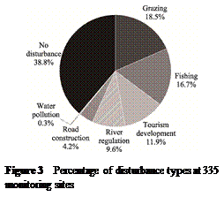 The recorded waterbirds were
found primarily in 3 types of wetland habitats, viz., lake wetlands, river wetlands, and marsh wetlands. The
following 6 categories of human disturbance were identified: grazing, fishing,
river regulation, tourism development, road construction, and water pollution.
Analysis of disturbed monitoring sites revealed that of the 335 monitoring
sites, 62 were affected by grazing, 56 were affected by fishing, and 40 were
affected by tourism development (Figure 3). Grazing was the most prevalent
disturbance type that affected 18.51% of the sites, followed by fishing
(16.72%) and tourism development (11.94%). Regarding disturbance intensity,
190 monitoring sites experienced weak disturbance, 130 experienced no
disturbance, and 15 were subject to moderate disturbance.
The recorded waterbirds were
found primarily in 3 types of wetland habitats, viz., lake wetlands, river wetlands, and marsh wetlands. The
following 6 categories of human disturbance were identified: grazing, fishing,
river regulation, tourism development, road construction, and water pollution.
Analysis of disturbed monitoring sites revealed that of the 335 monitoring
sites, 62 were affected by grazing, 56 were affected by fishing, and 40 were
affected by tourism development (Figure 3). Grazing was the most prevalent
disturbance type that affected 18.51% of the sites, followed by fishing
(16.72%) and tourism development (11.94%). Regarding disturbance intensity,
190 monitoring sites experienced weak disturbance, 130 experienced no
disturbance, and 15 were subject to moderate disturbance.
5 Discussion and Conclusion
Waterbirds inhabiting the vast wetlands of the
Qinghai section of the Yellow River Basin are an essential component of
biodiversity in Qinghai Province and play a vital role in biodiversity research
and conservation. Systematic surveys and long-term monitoring of waterbird
species composition, population size, spatial distribution, and habitat
conditions not only help track population trends but also reflect the current
status and evolution of wetland ecosystems. These efforts provide important
scientific guidance for the effective protection and management of waterbirds
and their habitats.
This study presents a basic analysis of waterbird
data collected during the post-breeding period in the Yellow River Basin in
Qinghai Province. A total of 65 species across 14 families and 7 orders were
recorded, with an overall count of 24,250 individuals. Diversity index analyses
were conducted for different river segments and survey units, which showed that
the middle section of the Yellow River Basin in Qinghai has relatively higher
species richness and diversity. Remarkably, the Lake Gengga sample area within
the 21 surveyed units recorded as many as 55 species totaling 3,870
individuals??representing one of the most significant contributions to the
dataset in terms of both species diversity and population abundance. This area
might provide diverse microhabitats and abundant food resources, making it an
attractive habitat and stopover site for numerous waterbirds. Nevertheless, compared with other survey units, this area currently lacks specific
protective measures. T. W. Connell??s Intermediate Disturbance
Hypothesis suggests that moderate levels of disturbance can promote species
diversity[14]. However, this hypothesis is not universally
applicable to all ecosystem types, and its applicability often depends on
specific environmental conditions. Furthermore, defining what constitutes
??moderate?? disturbance requires a case-by-case analysis due to large
differences in how various ecosystems respond to disturbances[15,16].
Therefore, grazing??the most common type of disturbance throughout the basin??may
either increase or reduce waterbird species diversity, which warrants further
investigation in future studies. In addition, the methodology used in
developing this dataset has several limitations. The division of survey units
may lack comprehensive coverage and sufficient spatial resolution. In terms of
bird classification and survey methods, reliance on classifications such as
diving birds (waterfowl) and wading birds (shorebirds) might overlook other
wetland-associated avian species. Moreover, direct counting and partitioned
counting methods encounter challenges and potential observational errors in
complex habitats. Regarding the evaluation of disturbance, the categorization
of disturbance types remains relatively coarse. Overall, there exists
considerable room for improvement in the systematic, scientific, and
operational aspects of the research methodology. Nonetheless, the data
collected during this monitoring effort on post-breeding waterbirds in the
Qinghai section of the Yellow River Basin provide foundational support for
subsequent ecological analyses and population dynamics prediction.
Author Contributions
Wang,
W., Ji, H. C., Wang, A. Z. designed the algorithms of dataset. Dong, Y. G.,
Cui, Q. C., Ji, H. C., Zhang, G. M., Tang, X. Y., Zhong, Y. T., Tang, B. Y.,
Yang, F., Zhao, H., Duo, W. K., Li, G. G., Sun, N., Shen, M. H., Wang, X. L.,
Wang, A. Z., Wang, W. contributed to the data processing and analysis. Dong, Y.
G. wrote the data paper.
Conflicts of Interest
The
authors declare no conflicts of interest.
References
[1]
Cui, Q. C., Ji, H. C., Zhang,
G. M., et al. County analysis of wetland
waterbird diversity in Qinghai Province [J].
Journal of Green Science and Technology, 2025, 27(8): 37?C42.
[2]
Wang, C. X., Zhang, Z. W., Xia,
S. X., et al. Seasonal and regional patterns and conservation strategies of waterbird
diversity in the Yellow River Basin [J]. Biodiversity Science, 2024, 32(11): 215?C223.
[3]
Wang, Q., Lv, X. G. Application
of waterbird to monitor and evaluate wetland ecosystem [J]. Wetland Science, 2007(3): 274?C281.
[4]
Zhang, S. X., Dong, Y. X., Xia,
F. Significance of waterbird monitoring in lake ecosystems [J]. Journal of Lake Sciences, 2011, 23(2):
155?C162.
[5]
Liu, W. X. The influence of breeding
and wintering ground conditions on the annual life cycle and behavior of two large
waterbird species [D]. Hefei: University
of Science and Technology of China, 2024.
[6]
Martin, T. E. Avian life history
evolution in relation to nest sites, nest predation, and food [J]. Ecological
Monographs, 1995, 65(1): 101?C127.
[7]
Wang, Q. X., Yang, C., Hu, D.
F., et al. Breeding population dynamics of Relict Gull (Larus
relictus) in Hongjian Nur, Shaanxi, China [J]. Animals (Basel),
2022, 12(8): 1035. DOI: 10.3390/ani12081035.
[8]
Dong,
Y. G., Cui, Q. C., Ji, H. C., et al.
Monitoring dataset of waterbirds in the late breeding seasonin the Qinghai section
of the Yellow River Basin
(2024) [J/DB/OL]. Digital Journal of Global ChangeData Repository, 2025. https://doi.org/10.3974/geodb.2025.03.08.V1.
[9]
GCdataPR
Editorial Office. GCdataPR data sharing policy [OL]. DOI: 10.3974/dp.policy.2014.05 (Updated 2017).
[10]
Shannon, C. E. A mathematical
theory of communication [J]. The Bell System Technical Journal, 1948, 27(3):
379?C423.
[11]
Simpson, E. H. Measurement
of diversity [J]. Nature, 1949, 163(4148): 688.
[12]
Pielou, E. C. The measurement
of diversity in different types of biological collections [J]. Journal of
Theoretical Biology, 1966, 13: 131?C144.
[13]
Berger, W. H., Parker, F. L.
Diversity of planktonic foraminifera in deep-sea sediments [J]. Science,
1970, 168(3937): 1345?C1347.
[14]
Connell, J. H. Diversity in
tropical rain forests and coral reefs [J]. Science, 1978, 199(4335): 1302?C1310.
DOI: 10.1126/science.199.4335.1302.
[15]
Bao, J., Lin, B. Q., Li, L. S.,
et al. Effect
of grazing on bird diversity in natural communities of Ulmus macrocarpa var. mongolica
in spring [J]. Journal of Jilin
Forestry Science and Technology, 2009, 38(5): 39?C41+51.
[16]
Luo, T. X., Liu, S. Influence
of the intermediate grazing disturbance on the biodiversity of grassland ecosystem
[J]. Journal of Anhui Agricultural Sciences, 2007, 35(21): 6567?C6568+6612.