Land Suitability Assessment Dataset of Six Economically
Important Desert Plants in Xinjiang Uygur Autonomous Region
Zhang, P.1,2 Wang, X. P.3 Fan, J. L.1,2 Zhang, G. F.4 Zhang, H.1,2* Yu, X. X.1,2
1. National Engineering Technology Research Center for
Desert-Oasis Ecological Construction, Xinjiang Institute of Ecology and
Geography, Chinese Academy of Sciences, Urumqi 830011, China;
2. Taklimakan Desert Ecosystem Field Observation and
Research Station of Xinjiang, Bayingolin Mongolian Autonomous Prefecture 841900,
China; 3. Zhongtan Energy (Shandong) Co., Ltd., Weifang 262700, China;
4. Central Taklimakan Desert Meteorological Station, Bayingolin
Mongolian Autonomous Prefecture 841000, China
Abstract: 6 plant species
(Isatis tinctoria L., Glycyrrhiza uralensis Fisch., Lycium
ruthenicum Murray, Carthamus tinctorius L., Hippophae rhamnoides
L., and Lycium dasystemum Pojark.) were selected to explore the areas
that are potentially suitable for growing economically important desert plants
in Xinjiang. Species distribution models (SDMs) were established for the 6
plants using the MaxEnt model using the points these 6 species were sample in
Xinjiang, along with 31 environmental variables categorized as bioclimate,
soil, and topography factors. The outputs of the constructed models, were used
to map and visualize the areas that are potentially suitable for growing the 6
desert plants under the current climate conditions in Xinjiang. The areas under
the curve of the suitability assessment models for each plant species were
larger than 0.8, indicating high prediction accuracy. Each dataset includes 2
data files: (1) the land suitability evaluation results for each plant (.txt
and .tif formats) and (2) spatial distribution point data (reference data) for
each plant (.xlsx and .shp formats).
Keywords: MaxEnt model; economic
desert plants; spatial distribution; suitable habitat
DOI: https://doi.org/10.3974/geodp.2025.02.09
Dataset Availability Statement:
The dataset supporting this
paper was published and is accessible through the Digital Journal of Global Change Data Repository at: https://doi.org/10.3974/geodb.2025.02.02.V1.
https://doi.org/10.3974/geodb.2025.02.03.V1. https://doi.org/10.3974/geodb.2025.02.04.V1.
https://doi.org/10.3974/geodb.2025.02.05.V1. https://doi.org/10.3974/geodb.2025.02.06.V1.
https://doi.org/10.3974/geodb.2025.02.07.V1.
1 Introduction
Predicting
suitable habitats for various species is a key focus in the field of ecology,
playing an important role in controlling pests[1], conserving rare
and endangered species[2,3], as well as introducing and cultivating
crops[4,5]. Species distribution models (SDMs) are tools for
predicting the potential geographic distribution of habitats that are suitable
for a species[6?C8]. The maximum entropy model (MaxEnt) is one of
SDMs providing a general machine learning method that uses known species
distribution records and their associated environmental variables to infer
ecological requirements, predicting potential suitable habitats within a
selected area[9,10]. The MaxEnt model has been widely used because
of only requiring a small number of samples, ease of operation, and high
prediction accuracy[11]. For example, Zhang[12] used the
MaxEnt model to predict areas suitable for Lycium ruthenicum Murray in
China, whereas Chen[13] predicted the geographic distribution of Hippophae
rhamnoides L. in Xinjiang using the MaxEnt model. Additionally, the MaxEnt
model has been applied for predicting crop distribution areas[14],
assessing the impact of climate change on species growth[15], and
optimizing the layout of species planting structures[16], etc.
Studies identifying the habitats that are
suitable for Isatis tinctoria L., Carthamus tinctorius L. and Lycium
dasystemum Pojark. are lacking, and these suitable areas have not been
visually analyzed in the Xinjiang region. Predictions of areas suitable for Glycyrrhiza
uralensis Fisch., Lycium ruthenicum Murray, and Hippophae
rhamnoides L. have primarily been conducted at the national scale, whereas
the predictions of suitable areas within Xinjiang require refinement[12,17,18].
Overall, additional research is needed to identify the habitats that are
suitable for these 6 economically important desert plants in Xinjiang.
This study focused on Isatis tinctoria
L., Glycyrrhiza uralensis Fisch., Lycium barbarum Pojark., Lycium
ruthenicum Murray, Carthamus tinctorius L., and Hippophae
rhamnoides L. Data on plant sample points and environmental variables were
obtained from the Global Biodiversity Information Facility (GBIF), WorldClim
2.1, and World Soil Databases using the MaxEnt model and ArcGIS. The spatial
distribution of the habitats suitable for these 6 species of desert plants in
Xinjiang was determined to provide a reference for rationally planning the use
of these plants in the region.
2 Metadata of the Dataset
Table 1 presents the meta data of land
suitability assessment dataset for Isatis tinctoria L.[19], Glycyrrhiza
uralensis Fisch.[20], Lycium dasystemum Pojark.[21],
Lycium ruthenicum Murray[22], Carthamus tinctorius L.[23],
and Hippophae rhamnoides L.[24] in Xinjiang Uygur Autonomous
Region of China. The table includes details such as the full names, short
names, authors, year of the datasets, temporal resolution, spatial resolution,
data formats, etc.
Table 1 Metadata summary of the datasets
|
Items
|
Description
|
|
Dataset full
name
|
Land suitability
assessment dataset for Isatis tinctoria L. in Xinjiang Uygur
Autonomous Region of China
|
|
Dataset short
name
|
Isatis tinctoria
L._XJSuitable
|
|
Authors
|
Zhang, P.,
Xinjiang Institute of Ecology and Geography, Chinese Academy of Sciences??z1571824849@163.com
Yu, X. X.,
Xinjiang Institute of Ecology and Geography, Chinese Academy of Sciences??yuxiangxiang@ms.xjb.ac.cn
Chang, C.,
Xinjiang Institute of Ecology and Geography, Chinese Academy of Sciences??changcun@ms.xjb.ac.cn
Zhang, H.,
Xinjiang Institute of Ecology and Geography, Chinese Academy of Sciences??zhangheng@ms.xjb.ac.cn
Fan, J. L.,
Xinjiang Institute of Ecology and Geography, Chinese Academy of Sciences??fanjl@ms.xjb.ac.cn
|
|
Geographical region
|
Xinjiang
|
|
Year
|
|
|
Temporal
resolution
|
Year
|
|
Spatial
resolution
|
30ʺ
|
|
Data format
|
.shp, .tif,
.xlsx, .txt
|
|
Data size
|
292 KB
|
|
Data files
|
Land suitability
assessment data for Isatis tinctoria L., coordinate points of
Isatis tinctoria L. (cited data)
|
|
Dataset full
name
|
Land suitability
assessment dataset for Glycyrrhiza uralensis Fisch. in Xinjiang Uygur
Autonomous Region of China
|
|
Dataset short
name
|
Glycyrrhiza
uralensis Fisch._XJSuitable
|
|
Authors
|
Zhang, P.,
Xinjiang Institute of Ecology and Geography, Chinese Academy of Sciences??z1571824849@163.com
Yu, X. X.,
Xinjiang Institute of Ecology and Geography, Chinese Academy of Sciences??yuxiangxiang@ms.xjb.ac.cn
Chang, C.,
Xinjiang Institute of Ecology and Geography, Chinese Academy of Sciences??changcun@ms.xjb.ac.cn
Ma, Q., Tarim
Oilfield branch of China National Petroleum Corporation, 462920056@qq.com
Wang, L., Tarim
Oilfield branch of China National Petroleum Corporation, 41063307@qq.com
Fan, J. L.,
Xinjiang Institute of Ecology and Geography, Chinese Academy of Sciences??fanjl@ms.xjb.ac.cn
|
|
Geographical
region
|
Xinjiang
|
|
Year
|
|
|
Temporal
resolution
|
Year
|
|
Spatial
resolution
|
30ʺ
|
|
Data format
|
.shp, .tif,
.xlsx, .txt
|
|
Data size
|
313 KB
|
|
Data files
|
Land suitability
assessment data for Glycyrrhiza uralensis Fisch., coordinate points of
Glycyrrhiza uralensis Fisch. (cited data).
|
|
Dataset full
name
|
Land suitability
assessment dataset for Lycium dasystemum Pojark. in Xinjiang Uygur
Autonomous Region of China
|
|
Dataset short
name
|
Lycium
dasystemum Pojark._XJSuitable
|
|
Authors
|
Zhang, P.,
Xinjiang Institute of Ecology and Geography, Chinese Academy of Sciences??z1571824849@163.com
Yu, X. X.,
Xinjiang Institute of Ecology and Geography, Chinese Academy of Sciences??yuxiangxiang@ms.xjb.ac.cn
Chang, C.,
Xinjiang Institute of Ecology and Geography, Chinese Academy of Sciences??changcun@ms.xjb.ac.cn
Zhang, H.,
Xinjiang Institute of Ecology and Geography, Chinese Academy of Sciences??zhangheng@ms.xjb.ac.cn
Fan, J. L.,
Xinjiang Institute of Ecology and Geography, Chinese Academy of Sciences??fanjl@ms.xjb.ac.cn
|
(To be
continued on the next page)
(Continued)
|
Items
|
Description
|
|
Geographical
region
|
Xinjiang
|
|
Year
|
|
|
Temporal
resolution
|
Year
|
|
Spatial
resolution
|
30ʺ
|
|
Data format
|
.shp, .tif,
.xlsx, .txt
|
|
Data size
|
285 KB
|
|
Data files
|
Land suitability
assessment data for Lycium dasystemum Pojark., coordinate points of Lycium
dasystemum Pojark. in Xinjiang (cited data).
|
|
Dataset full
name
|
Land suitability
assessment dataset for Lycium ruthenicum Murray in Xinjiang Uygur
Autonomous Region of China
|
|
Dataset short
name
|
Lycium
ruthenicum Murray_XJSuitable
|
|
Authors
|
Zhang, P.,
Xinjiang Institute of Ecology and Geography, Chinese Academy of Sciences??z1571824849@163.com
Yu, X. X.,
Xinjiang Institute of Ecology and Geography, Chinese Academy of Sciences??yuxiangxiang@ms.xjb.ac.cn
Chang, C.,
Xinjiang Institute of Ecology and Geography, Chinese Academy of Sciences??changcun@ms.xjb.ac.cn
Zhang, H.,
Xinjiang Institute of Ecology and Geography, Chinese Academy of Sciences??zhangheng@ms.xjb.ac.cn
Fan, J. L.,
Xinjiang Institute of Ecology and Geography, Chinese Academy of Sciences??fanjl@ms.xjb.ac.cn
|
|
Geographical
region
|
Xinjiang
|
|
Year
|
|
|
Temporal
resolution
|
Year
|
|
Spatial
resolution
|
30??
|
|
Data format
|
.shp, .tif,
.xlsx, .txt
|
|
Data size
|
332 KB
|
|
Data files
|
Land suitability
assessment data for Lycium ruthenicum Murray, coordinate points of Lycium
ruthenicum Murray (cited data)
|
|
Dataset full
name
|
Land suitability
assessment dataset for Carthamus tinctorius L. in Xinjiang Uygur
Autonomous Region of China
|
|
Dataset short
name
|
Carthamus
tinctorius L._XJSuitable
|
|
Authors
|
Zhang, P.,
Xinjiang Institute of Ecology and Geography, Chinese Academy of Sciences??z1571824849@163.com
Yu, X. X.,
Xinjiang Institute of Ecology and Geography, Chinese Academy of Sciences??yuxiangxiang@ms.xjb.ac.cn
Chang, C.,
Xinjiang Institute of Ecology and Geography, Chinese Academy of Sciences??changcun@ms.xjb.ac.cn
Zhang, H.,
Xinjiang Institute of Ecology and Geography, Chinese Academy of Sciences??zhangheng@ms.xjb.ac.cn
Fan, J. L.,
Xinjiang Institute of Ecology and Geography, Chinese Academy of Sciences??fanjl@ms.xjb.ac.cn
|
|
Geographical
region
|
Xinjiang
|
|
Year
|
|
|
Temporal
resolution
|
Year
|
|
Spatial
resolution
|
30ʺ
|
|
Data format
|
.shp, .tif,
.xlsx, .txt
|
|
Data size
|
231 KB
|
|
Data files
|
Land suitability
assessment data for Carthamus tinctorius L. coordinate points of Carthamus
tinctorius L. (cited data)
|
|
Dataset full
name
|
Land suitability
sssessment dataset for Hippophae rhamnoides L. in Xinjiang Uygur
Autonomous Region of China
|
|
Dataset short
name
|
Hippophae
rhamnoides L._XJSuitable
|
|
Authors
|
Zhang, P.,
Xinjiang Institute of Ecology and Geography, Chinese Academy of Sciences??z1571824849@163.com
|
(To be
continued on the next page)
(Continued)
|
Items
|
Description
|
|
Authors
|
Yu, X. X.,
Xinjiang Institute of Ecology and Geography, Chinese Academy of Sciences??yuxiangxiang@ms.xjb.ac.cn
Chang, C.,
Xinjiang Institute of Ecology and Geography, Chinese Academy of Sciences??changcun@ms.xjb.ac.cn
Zhang, H.,
Xinjiang Institute of Ecology and Geography, Chinese Academy of Sciences??zhangheng@ms.xjb.ac.cn
Fan, J. L.,
Xinjiang Institute of Ecology and Geography, Chinese Academy of Sciences??fanjl@ms.xjb.ac.cn
|
|
Geographical
region
|
Xinjiang
|
|
Year
|
|
|
Temporal
resolution
|
Year
|
|
Spatial
resolution
|
30ʺ
|
|
Data format
|
.shp, .tif,
.xlsx, .txt
|
|
Data size
|
378 KB
|
|
Data files
|
Land suitability
assessment data for Hippophae rhamnoides L., coordinate points of Hippophae
rhamnoides L. in Xinjiang (cited data).
|
|
Foundation
|
Xinjiang Uygur
Autonomous Region, China (2022B03030)
|
|
Data computing environment
|
MaxEnt, ArcGIS
|
|
Data publisher
|
Global Change
Research Data Publishing & Repository, http://www.geodoi.ac.cn
|
|
Address
|
No. 11A, Datun
Road, Chaoyang District, Beijing 100101, China
|
|
Data sharing
policy
|
(1) Data
are openly available and can be free downloaded via the Internet; (2) End
users are encouraged to use Data subject to citation; (3) Users, who
are by definition also value-added service providers, are welcome to
redistribute Data subject to written permission from the GCdataPR
Editorial Office and the issuance of a Data redistribution license;
and (4) If Data are used to compile new datasets, the ??ten percent
principal?? should be followed, such that Data records utilized should
not surpass 10% of the new dataset contents, while sources should be clearly
noted in suitable places in the new dataset[25].
|
|
Communication and searchable systems
|
DOI, CSTR,
Crossref, DCI, CSCD, CNKI, SciEngine, WDS, GEOSS, PubScholar, CKRSC
|
3 Methods
3.1 Data Sources
3.1.1 Plant Distribution Data
The
plant distribution data were obtained from the GBIF, with sampling spanning from 1949 to 2020. We
acquired precise latitudinal and longitudinal information on the distribution
of the sampling points of Isatis tinctoria L., Glycyrrhiza uralensis
Fisch., Lycium ruthenicum Murray, Carthamus tinctorius L., Hippophae
rhamnoides L., and Lycium dasystemum Pojark. within
the Xinjiang region using this platform[26]. These data served as the foundation for determining the spatial
distribution for each plant.
3.1.2 Environmental Factor Data
A
total of 31 environmental datasets were selected for modeling, which included
19 bioclimatic (Bio1?CBio19) and 9 soil variables, as well as elevation, slope,
and aspect. The data for the 19 bioclimatic variables and elevation were
obtained from the WorldClim2.1 database[27].
The slope and aspect data were derived from elevation data using ArcGIS, and
surface soil data were sourced from the National Cryosphere Desert Data Center[28].
The environmental variables are listed in Table 2.
Table 2 List
of environmental variables used in MaxEnt model
|
Type
|
Variable
|
Description
|
Unit
|
|
Bioclimate variables
|
Bio1
|
Annual mean temperature
|
??
|
|
Bio2
|
Mean diurnal range
|
??
|
|
Bio3
|
Isothermality ((Bio2/Bio7)??100??
|
\
|
|
Bio4
|
Temperature seasonality (standard deviation
??100)
|
\
|
|
Bio5
|
Max. temperature of the warmest month
|
??
|
|
Bio6
|
Min. temperature of the coldest month
|
??
|
|
Bio7
|
Temperature annual range (Bio5?CBio6)
|
??
|
|
Bio8
|
Mean temperature of the wettest quarter
|
??
|
|
Bio9
|
Mean temperature of the driest quarter
|
??
|
|
Bio10
|
Mean temperature of the warmest quarter
|
??
|
|
Bio11
|
Mean temperature of the coldest quarter
|
??
|
|
Bio12
|
Annual precipitation
|
mm
|
|
Bio13
|
Precipitation of the wettest month
|
mm
|
|
Bio14
|
Precipitation of the driest month
|
mm
|
|
Bio15
|
Precipitation seasonality
|
\
|
|
Bio16
|
Precipitation of the wettest quarter
|
mm
|
|
Bio17
|
Precipitation of the driest quarter
|
mm
|
|
Bio18
|
Precipitation of the warmest quarter
|
mm
|
|
Bio19
|
Precipitation of the coldest quarter
|
mm
|
|
Terrain
|
Elev
|
Elevation
|
m
|
|
Slope
|
Slope
|
??
|
|
Aspect
|
Aspect
|
\
|
|
Soil variables
|
T_CaCO3
|
Topsoil calcium carbonate
|
%
|
|
T_cec_soil
|
Topsoil CEC (soil)
|
cmol/kg
|
|
T_clay
|
Topsoil clay fraction
|
%
|
|
T_esp
|
Topsoil sodicity (ESP)
|
\
|
|
T_gravel
|
Topsoil gravel content
|
%
|
|
TOC
|
Topsoil organic carbon
|
%
|
|
T_pH_H2O
|
Topsoil pH (H2O)
|
?Clog(H+)
|
|
T_sand
|
Topsoil sand fraction
|
%
|
|
T_texture
|
Topsoil texture
|
|
3.2 Methodology
3.2.1 Data Processing
We
focused on Xinjiang for the 6 plants species. The spatial resolution of the
environmental factor layer was 30 arcseconds, and the climatic factor data
within the same grid cell were identical. Redundant or duplicate distribution
data within the same grid cell caused overfitting. Therefore, ENMTools software
was used to filter the collected distribution data. ENMTools is open-source
software for modeling and predicting species distribution, providing a suite of
tools that help researchers extract information from large species distribution
datasets. This tool was used to automatically match the resolution of the
environmental factor layer used in the analysis and remove the redundant data
within the same grid cell, enhancing the accuracy of the model-fitting results.
3.2.2 Environmental Variables
Correlations exist among
environmental factors, as such, incorporating all the environmental factors
into the model would have resulted in overfitting. Precisely quantifying the
relationships between known locations of species and their corresponding
environmental variables forms the foundation for modeling species distribution.
Environmental variables that are ecologically relevant should be selected to
minimize the collinearity among variables and prevent model overfitting during
distribution simulations[29]. The correlation among the variables
was analyzed using ENMTools software to generate pairwise correlation
coefficients among the environmental factors to address collinearity-induced
overfitting (Figure 1). The correlation coefficient quantitatively measures the
linear relationships between variables, ranging from ?C1 (perfect negative
correlation) to 1 (perfect positive correlation). Absolute values approaching 1
indicate stronger correlations. All 31 environmental variables were
incorporated into the initial modeling to assess the contribution rates of the
individual variables. Subsequently, the factors demonstrating both high collinearity
(absolute correlation coefficient ??0.8) and low ecological relevance
(contribution rate <0.5) were excluded based on established criteria[30].
A refined set of environmental variables was then used to construct the final
model.
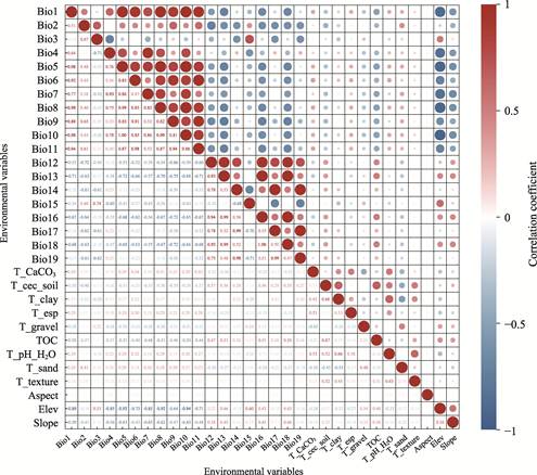
Figure
1 Results of
correlation analysis of environmental factors
3.2.3 Maximum Entropy Modeling
The species distribution and environmental data were processed and
then imported into MaxEnt for training and validating the model. A
cross-validation approach was implemented for each species by partitioning all
occurrence records into 10 subsets, with 1 and 9 subsets used for testing and
training, respectively. The modeling parameters were configured for a maximum
of 10,000 iterations and a logistic output format. Variable importance was
evaluated using the jackknife method with response curve generation. The
modeling process was repeated through 10-fold cross-validation to minimize
uncertainty, with the final predictions derived by averaging all the replicate
results.
The
accuracy of the model was evaluated using the area under the receiver operating
characteristic curve (ROC) of the MaxEnt outputs. The ROC curve demonstrates
the relationship between the correctly predicted distribution points and false
predictions at different thresholds. The area under the curve (AUC) ranges from
0 to 1, with higher values corresponding to higher prediction reliability. AUC
values below 0.8, between 0.8 and 0.9, and from 0.9 to 1.0 represent low,
moderate, and high accuracy, respectively[31].
3.2.4 Delineation and Spatiotemporal Dynamics of Suitable Areas
The operational results of the
MaxEnt model were imported into ArcGIS 10.8 software, where the
reclassification function in the spatial analysis module was used to process
the generated raster data files. Area
distribution maps were created for the 6 plants species across Xinjiang. The
suitability values predicted using the MaxEnt model were continuous raster data
ranging from 0 to 1. Habitat suitability was classified into 4 categories:
inappropriate, low suitable, medium suitable, and highly suitable based on the
natural break method[32]. Table 3 lists the specific natural break
thresholds for the suitability of each plant species.
Table 3
Classification criteria determined using natural break method
|
Plant name
|
Inappropriate area
|
Low suitable area
|
Medium suitable area
|
Highly suitable area
|
|
Isatis
tinctoria L.
|
0‒0.06
|
0.06‒0.23
|
0.23‒0.49
|
0.49‒1
|
|
Glycyrrhiza
uralensis Fisch.
|
0‒0.09
|
0.09‒0.26
|
0.26‒0.51
|
0.51‒1
|
|
Lycium
ruthenicum Murray
|
0‒0.08
|
0.08‒0.25
|
0.25‒0.52
|
0.52‒1
|
|
Carthamus
tinctorius L.
|
0‒0.07
|
0.07‒0.22
|
0.22‒0.49
|
0.49‒1
|
|
Hippophae
rhamnoides L.
|
0‒0.09
|
0.09‒0.26
|
0.26‒0.54
|
0.54‒1
|
|
Lycium
dasystemum Pojark.
|
0‒0.07
|
0.07‒0.23
|
0.23‒0.50
|
0.50‒1
|
|

Figure 2 Flowchart of the dataset development
|
The technical roadmap of
this study is shown in Figure 2.
4 Data Results and Validation
4.1 Dataset Composition
6 datasets were constructed, each
containing 2 data files: (1) land suitability assessment data for economically
important desert plants in Xinjiang (Isatis tinctoria L., Glycyrrhiza
uralensis Fisch., Lycium ruthenicum Murray, Carthamus
tinctorius L., Hippophae rhamnoides L., and Lycium dasystemum
Pojark.), archived in .txt and .tif formats; (2) coordinate points of the 6
plants in Xinjiang (cited data), which were archived in. xlsx and .shp formats.
4.2 Data Products
4.2.1 Filtering Data and Evaluating
Accuracy of MaxEnt Model
The
distribution data were filtered using ENMTools, resulting in the final
selection of 22, 36, 43, 19, 66, and 16 sample points for Isatis tinctoria
L., Glycyrrhiza uralensis Fisch., Lycium ruthenicum Murray, Carthamus
tinctorius L., Hippophae rhamnoides L., and Lycium dasystemum
Pojark, respectively. The environmental variables were screened based on the
results of correlation analysis and the contribution rates, retaining 13, 15,
16, 13, 15, and 15 variables for each species, as illustrated in Figure 3. The
AUCs of the suitability assessment model for these species (Figure 3) were
0.950, 0.874, 0.877, 0.905, 0.896, and 0.943, respectively. All AUC values
exceeded 0.8, demonstrating the reliability of the MaxEnt model. The AUC values
for Isatis tinctoria L., Carthamus tinctorius L., and Lycium
dasystemum Pojark. were higher than 0.9, indicating high prediction
accuracy.
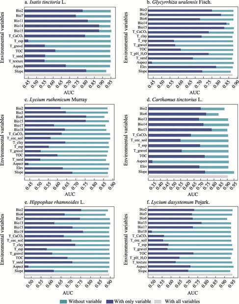
Figure
3 AUC values of
predictive models for 6 economically important desert plants
4.2.2 Distribution Ranges of 6 Plants
Under Current Climatic Conditions
The areas potentially suitable
for Isatis tinctoria L., Glycyrrhiza uralensis Fisch., Lycium
ruthenicum Murray, Carthamus tinctorius L., Hippophae rhamnoides
L., and Lycium dasystemum Pojark. for Xinjiang under current climatic
conditions are shown in Figure 4. These 6 plants predominantly inhabit the
oasis regions in Xinjiang, and their potential distributions widely vary. The
specific distribution patterns are described in detail below.
(1) Northwestern Xinjiang is the
area highly suitable for Isatis tinctoria L. cultivation, mainly
including the Ili Kazakh Autonomous Prefecture, Tacheng, and Altay. The areas that are medium
suitable include the Tacheng, Ili
Kazakh Autonomous Prefecture, and Changji Hui Autonomous
Prefecture.
Low suitable area mainly covers the Hami Diqu (Region), certain oasis zones
in southern Xinjiang, and the Gurbantunggut Shamo (Desert). Southern Xinjiang
is mostly inappropriate for growing Isatis tinctoria L. (Figure 4a).
(2) The areas that are highly
suitable for cultivating Glycyrrhiza uralensis Fisch. include northern Xinjiang, where the
distribution pattern is fragmented. Medium suitable areas surround these
high-suitability zones, whereas the low suitable areas mainly include the Hami Diqu (Region), Bayingolin Mongol Autonomous
Prefecture,
Aksu, and Kashgar. Southern Xinjiang,
particularly in the southern Bayingolin Mongol
Autonomous Prefecture and Hotan Diqu (Region), is inappropriate (Figure
4b).
(3) The areas highly suitable for
cultivating Lycium ruthenicum Murray are more prevalent in southern than
in northern Xinjiang, with belt-shaped formations. This species is
predominantly found in the oasis zones in southern Xinjiang spanning the
Hotan-Kashgar-Kizilsu Kirghiz-Aksu, whereas the populations in northern
Xinjiang are mainly distributed along the Bortala-Tacheng-Changji-Urumqi-Turpan oasis belt. The medium suitable areas mainly include the Tacheng; and the Bayingolin Mongol Autonomous
Prefecture
and the eastern Altay are low suitable areas (Figure 4c).
(4) The main areas that are
highly suitable for cultivating Carthamus tinctorius L. include the
oasis regions throughout various prefectures, with the distribution being
sparse and fragmented. The medium suitable areas cluster in the northwestern Tacheng and western Altay. the less-suitable areas
primarily occur within the Tacheng. The inappropriate
areas include eastern Xinjiang, with notable concentrations in Altay, Hami, Bayingolin
Mongol Autonomous Prefecture, and Hotan (Figure 4d).
(5) Areas highly suitable for
growing Hippophae rhamnoides L. are the oasis regions throughout various
prefectures, with the distribution being patchy and primarily concentrated in the Ili Kazak Autonomous Prefecture and Kashgar. The medium suitable
area is the in Tacheng, whereas the low suitable areas
mainly include the Hami, Kizilsu
Klrgiz Autonomous Prefecture, and the southern Kashgar. Areas inappropriate
for Hippophae rhamnoides L. cultivation are concentrated in southern
Xinjiang, particularly in the southern Bayingolin
Mongol Autonomous Prefecture and northern Hotan (Figure 4e).
(6) Northern Xinjiang is highly
suitable for Lycium dasystemum Pojark., with a patchy distribution
pattern, with scattered occurrences in the Hotan and Kashgar in southern Xinjiang. The medium suitable area mainly includes
the Tacheng and Altay, whereas the low suitable areas
are primarily located in western Hotan, eastern Kashgar, western Altay, and Hami. The main area that
is inappropriate is the southern Bayingolin Mongol
Autonomous Prefecture (Figure 4f).
Overall, the highly and medium
suitable areas for cultivating the 6 plants are limited in Xinjiang, with the
highly suitable areas covering less than 5% of the region. The areas highly
suitable for growing Glycyrrhiza uralensis Fisch., Hippophae
rhamnoides L., and Lycium dasystemum Pojark. cover 3.61%, 2.58%, and
2.46% of the region, respectively. Most areas were classified as inappropriate,
with 86.27%, 84.40%, and 75.01% of the region being unsuitable for Carthamus
tinctorius L., Isatis tinctoria L., and Lycium ruthenicum
Murray, respectively. The proportion of inappropriate land was smallest for Glycyrrhiza
uralensis Fisch., at 69.91%. The proportions of low suitable area was
largest and smallest for Lycium dasystemum Pojark. (17.98%) and Carthamus
tinctorius L. (9.39%), respectively.
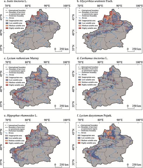
Figure
4 Land
suitability maps for the 6 economically important desert plants in Xinjiang
5 Discussion and Conclusion
A
model was developed for predicting the habitats that are suitable for
economically important desert plants in Xinjiang using MaxEnt and ArcGIS.
Various environmental variables, such as bioclimate, topography, and soil
characteristics, were incorporated into the model. The habitats were
categorized into 4 suitability grades using the natural break method, with the
AUC of all plant suitability assessment models exceeding 0.8, confirming the
ecological validity of the predictions. The areas that are potentially suitable
for the 6 plants in Xinjiang are spatially heterogeneous, with the distribution
patterns strongly correlating with locations of oasis ecosystems. Highly
suitable areas accounted for less than 5% of the total region, with 3.61%,
2.58%, and 2.46% of the region being highly suitable for Glycyrrhiza
uralensis Fisch., Hippophae rhamnoides L., and Lycium dasystemum
Pojark., respectively.
A dataset was
constructed of the habitats that are suitable for these plants in Xinjiang,
which provides a reference for the spatial planning of desert-based agriculture
and provides scientific support for sustainable plant resource use. Future
studies should investigate the spatiotemporal dynamics of the habitats of
economically important desert plants under projected climate change scenarios,
quantify future centroid migration rates across different suitability zones,
and evaluate the long-term sustainability of the plant resources in deserts.
Author
Contributions
Zhang, P. collected, processed the data, and drafted the
manuscript. Wang, X. P., Zhang, G. F. and Zhang, H. contributed to the data
processing. Fan, J. L. designed the overall framework for developing the
dataset. Zhang, H. and Yu, X. X. supervised the writing of this paper.
Conflicts
of Interest
The authors declare no conflicts
of interest.
References
[1]
Qin,
X. S., Li, M. X. Predicting the potential distribution of Oxalis debilis
Kunth, an invasive species in China with a maximum entropy model [J]. Plants,
2023, 12(23): 3999.
[2]
Zhao, D.,
Wang, J., Dai, W., et al. Effects of climate warming and human
activities on the distribution patterns of Fritillaria unibracteata in
eastern Qinghai-Tibetan Plateau [J]. Scientific Reports, 2023, 13:
15770.
[3]
Lin, H. D.,
Zheng, Q. Z., Shen, L. Q., et al. Assessment of habitat suitability in
autumn for wild alpine musk deer in Xinglongshan National Nature Reserve with
MaxEnt model [J]. Chinese Journal of Ecology, 2024, 43(1): 299?C304.
[4]
Deng, C.
R., Zhong, Q. W., Shao, D. K., et al. Potential suitable habitats of
chili pepper in China under climate change [J]. Plants, 2024, 13(7):
1027.
[5]
Li, J. L.,
Deng, C. R., Duan, G. Z., et al. Potentially suitable habitats of Daodi
goji berry in China under climate change [J]. Frontiers in Plant Science,
2024, 14: 1279019.
[6]
Evans, J.
M., Fletcher, R. J., Alavalapati, J. Using species distribution models to
identify suitable areas for biofuel feedstock production [J]. Global Change
Biology Bioenergy, 2010, 2(2), 63?C78.
[7]
Zhao, Y.,
Deng, X. W., Xiang, W. H., et al. Predicting potential suitable habitats
of Chinese fir under current and future climatic scenarios based on MaxEnt
model [J]. Ecological Informatics, 2021, 64:101393.
[8]
Zhao, Z.
Y., Xiao, N. W., Shen, M., et al. Comparison between optimized MaxEnt
and random forest modeling in predicting potential distribution: a case study
with Quasipaa boulengeri in China [J]. Science of the Total
Environment, 2022, 842: 156867.
[9]
Kang, J.
F., Liu, M. S., Qu, M. K., et al. Identifying the potential soil
pollution areas derived from the metal mining industry in China using MaxEnt
with mine reserve scales (MaxEnt_MRS) [J]. Environmental Pollution,
2023, 329: 121687.
[10]
Phillips,
S. J., Anderson, R. P., Schapire, R. E. Maximum entropy modeling of species
geographic distributions [J]. Ecological Modelling, 2006, 190(3?C4):
231?C259.
[11]
Phillips,
S. J., Dudik, M. Modeling of species distributions with MaxEnt: new extensions
and a comprehensive evaluation [J]. Ecography, 2008, 31(2): 161?C175.
[12]
Zhang, L.
Wei, Y. Q., Wang, J. N., et al. The potential geographical distribution
of Lycium ruthenicum Murr. under different climate change scenarios [J].
Chinese Journal of Applied and Environmental Biology, 2020, 26(4):
969?C978.
[13]
Chen, S.
Q., Dong, H. F., Yue, Y. F., et al. Geographical distribution and
dynamic change prediction of Hippophae rhamnoides subsp. sinensis under
different climate scenarios [J]. Arid Zone Research, 2024, 41(9):
1560?C1571.
[14]
Zhou, D.
M., Zhang, R. Z., Sun, W. C., et al. Study on climatic suitability for
winter rapeseed planting in arid and cold regions in north China [J]. Scientia
Agricultura Sinica, 2014, 47(13): 2541?C2551.
[15]
Gan, X. L.,
Chang, Y. P., Jiang, Y., et al. Impact of climate change on potential
distribution of Amygdalus mongolicain the Qilian Mountains [J]. Acta
Ecologica Sinica, 2023, 43(2): 768?C776.
[16]
Yang, R.
Z., Zhou, G. S. A comprehensive risk assessment of the main maize
agrometeorological disasters in the three provinces of Northeast China [J]. Acta
Meteorologica Sinica, 2015, 73(6): 1141?C1153.
[17]
Xue, H. B.,
Liu, M. L., Li, L. S., et al. Prediction of suitable regions suitable
for Glycyrrhiza uralensis based on MaxEnt model [J]. Shaanxi Forest
Science and Technology, 2024, 52(3): 19?C25.
[18]
Zhang, X.
W., Jiang, Y. M., Bi, Y., et al. Identification of potential
distribution area for Hippophae rhamnoidessubsp.sinensis by the
MaxEnt model [J]. Acta Ecologica Sinica, 2022, 42(4): 1420-1428.
[19]
Zhang, P.,
Yu, X. X., Chang, C., et al. Land suitability assessment dataset for Isatis
tinctoria L. in Xinjiang Uygur Autonomous Region of China [J/DB/OL].
Digital Journal of Global Change Data Repository, 2025.
https://doi.org/10.3974/geodb.2025.02.02.V1.
[20]
Zhang, P.,
Yu, X. X., Chang, C., et al. Land suitability assessment dataset for Glycyrrhiza
uralensis Fisch. in Xinjiang Uygur Autonomous Region of China [J/DB/OL]. Digital
Journal of Global Change Data Repository, 2025.
https://doi.org/10.3974/geodb.2025.02.03.V1.
[21]
Zhang, P.,
Yu, X. X., Chang, C., et al. Land suitability assessment dataset for Lycium
dasystemum Pojark. in Xinjiang Uygur Autonomous Region of China [J/DB/OL]. Digital
Journal of Global Change Data Repository, 2025.
https://doi.org/10.3974/geodb.2025.02.04.V1.
[22]
Zhang, P.,
Yu, X. X., Chang, C., et al. Land suitability assessment dataset for Lycium
ruthenicum Murray in Xinjiang Uygur Autonomous Region of China [J/DB/OL]. Digital
Journal of Global Change Data Repository, 2025.
https://doi.org/10.3974/geodb.2025.02.05.V1.
[23]
Zhang, P.,
Yu, X. X., Chang, C., et al. Land suitability assessment dataset for Carthamus
tinctorius L. in Xinjiang Uygur Autonomous Region of China [J/DB/OL]. Digital
Journal of Global Change Data Repository, 2025.
https://doi.org/10.3974/geodb.2025.02.06.V1.
[24]
Zhang, P.,
Yu, X. X., Chang, C., et al. Land suitability assessment dataset for Hippophae
rhamnoides L. in Xinjiang Uygur Autonomous Region of China [J/DB/OL]. Digital
Journal of Global Change Data Repository, 2025.
https://doi.org/10.3974/geodb.2025.02.07.V1.
[25]
GCdataPR
Editorial Office. GCdataPR data sharing policy [OL].
https://doi.org/10.3974/dp.policy.2014.05 (Updated 2017).
[26]
GBIF.org
User. Occurrence download [OL]. The Global Biodiversity Information Facility.
2024. https://doi.org/10.15468/dl.s9sy5y.
[27]
Fick, S. E., Hijmans, R. J. WorldClim 2: new 1km spatial resolution
climate surfaces for global land areas [J]. International Journal of Climatology, 2017, 37
(12): 4302?C4315.
[28]
Lu, L.,
Liu, C. Chinese soil dataset based on the World Soil Database (HWSD) (v1.1)
[DB/OL]. National Cryosphere Desert Data Center (http://www.ncdc.ac.cn), 2020.
https://cstr.cn/CSTR:11738.11.ncdc.Westdc. 2020.585.
[29]
Fang, J.
Q., Shi, J. F., Zhang, P., et al. Potential distribution projections for
Senegalia senegal (L.) Britton under climate change scenarios [J]. Forests,
2024, 15(2): 379.
[30]
Tarnian,
F., Kumar, S., Azarnivand, H., et al. Assessing the effects of climate
change on the distribution of Daphne mucronata in Iran [J]. Environmental
Monitoring and Assessment, 2021, 193(9): 562.
[31]
Cecilia, A.
C., Francisco, N. L., Ricardo, C. T., et al. Effects of environmental
changes on the occurrence of Oreomunnea mexicana (Juglandaceae) in a
biodiversity hotspot cloud forest [J]. Forests, 2017, 8(8): 261.
[32]
Shao,
M. H., Wang, L., Li, B. W., et al. Maxent modeling for identifying the
nature reserve of Cistanche deserticola Ma under effects of the host (Haloxylon
Bunge) forest and climate changes in Xinjiang, China [J]. Forests, 2022, 13(2): 189.