Dataset
Development of Accessibility of Public Service Facilities among Townships of
Qinghai-Xizang Plateau (2020)
Guo, K. F. Dai, T. Q.* Zhang, L. L.
Faculty of Geographical Science, Beijing Normal
University, Beijing 100875, China
Abstract:
Accessibility to public service facilities serves as a critical metric for
guiding the planning and development of transportation systems and public
infrastructure. In recent years, the construction of roads and public service
facilities on the Qinghai-Xizang Plateau has significantly enhanced regional
accessibility. This study developed a township-level dataset (2020) to assess
the accessibility of public service facilities across the Qinghai-Xizang
Plateau. The dataset integrates road network data, points of interest (POI) and
slope analyses to quantify the shortest travel time (in hours) from each
township to key urban centers (prefecture-level cities and county) and
facilities, including stores, banks, hospitals and junior high schools. The
results reveal that the average travel times from townships to the nearest
prefecture-level city, county, store, bank, hospital, and junior high school
are 5.52 h, 1.96 h, 1.45 h, 1.48 h, 2.13 h, and 1.90 h, respectively.
Significant regional disparities are observed: accessibility is relatively
higher within prefecture-level city jurisdictions but diminishes in peripheral
county areas. To further advance research aimed at improving the quality of
life for residents on the Qinghai-Xizang Plateau, future studies could expand
this dataset by incorporating metrics such as facility capacity and service
coverage. The dataset is archived in .shp format, with a total size of 86.4 MB
(compressed into one file, 53.2 MB).
Keywords: Qinghai-Xizang Plateau; accessibility; public service facilities
DOI: https://doi.org/10.3974/geodp.2025.02.08
Dataset Availability Statement:
The dataset
supporting this paper was published and is accessible through the Digital Journal of Global Change Data Repository at:
https://doi.org/10.3974/geodb.2025.03.04.V1.
Public service facilities, including educational institutions,
healthcare providers, commercial services, financial infrastructure, community
resources, utilities and administrative centers form the basis of societal
development. Accessibility, defined as the ease of reaching these facilities
from a given location[1], has emerged as a critical focus in urban
planning and regional development. It serves not only as the aim of
transportation projects but also as a key metric for evaluating developmental
equity. Recent studies further investigate its correlations with demographic
patterns, economic productivity and resident satisfaction[2?C5].
The Qinghai-Xizang Plateau,
with its extreme climate, complex topography and fragile ecosystems, presents
unique challenges for sustainable development. While two decades of
infrastructure expansion have significantly improved connectivity and service
availability[6], systematic assessments of accessibility remain
scarce. This paper addresses this gap by developing a township-level
accessibility dataset that integrates road networks, Points of Interest (POI),
and slope-adjusted travel speeds. The dataset quantifies travel times to
essential destinations, i.e., prefecture-level city, county, store, shop, bank,
hospital, and junior high school and provides a foundation for optimizing
resource allocation and supporting interdisciplinary research in economic
growth, ecological conservation and tourism planning.
2 Metadata of the Dataset
The name, author, geographic area, data year, spatial resolution,
data files, data publishing and sharing service platform, data sharing policy
and other information of the Dataset on accessibility of public service
facilities among townships of Qingzang Plateau (2020)[7] are shown
in Table 1.
Table 1
Metadata
Summary of the Dataset on accessibility of public service facilities among
townships of Qingzang Plateau (2020)
|
Items
|
Description
|
|
Dataset full name
|
Dataset on accessibility of public service
facilities among townships of Qingzang Plateau (2020)
|
|
Dataset short name
|
Qztime_2020
|
|
Authors
|
Guo, K. F., Beijing Normal University,
202431051039@mail.bnu.edu.cn
Dai,
T. Q., Beijing Normal University, daiteqi@bnu.edu.cn
|
|
Zhang, L. L., Beijing Normal University,
202221051066@mail.bnu.edu.cn
|
|
Geographic area
|
Qinghai-Xizang Plateau, China
|
|
Year
|
2020
|
|
Spatial resolution
|
Township
|
|
Data format
|
.shp
|
|
|
|
Data size
|
86.4 MB
|
|
|
|
Data files
|
The accessibility calculation results of
townships in Qinghai-Xizang Plateau to cities, counties, stores, banks,
hospitals and junior high schools
|
|
Foundation
|
Ministry of Science and Technology of P.
R. China (2019QZKK0406)
|
|
Data publisher
|
Global Change
Research Data Publishing & Repository, http://www.geodoi.ac.cn
|
|
Address
|
No. 11A, Datun Road, Chaoyang District,
Beijing 100101, China
|
|
Data sharing policy
|
(1) Data are openly available and
can be free downloaded via the Internet; (2) End users are encouraged to use Data
subject to citation; (3) Users, who are by definition also value-added
service providers, are welcome to redistribute Data subject to
written permission from the GCdataPR Editorial Office and the issuance of a Data
redistribution license; and (4) If Data are used to compile new
datasets, the ??ten percent principal?? should be followed such that Data
records utilized should not surpass 10% of the new dataset contents, while
sources should be clearly noted in suitable places in the new dataset[8]
|
|
Communication and
searchable system
|
DOI, CSTR,
Crossref, DCI, CSCD, CNKI, SciEngine, WDS, GEOSS, PubScholar, CKRSC
|
3 Methods
3.1 Data Sources
The data used in this dataset includes:
(1) The road network data
comes from the Second Tibetan Plateau Scientific Expedition and Research
(2019QZKK0406), which is the road network of this region in 2020;
(2) Use SRTM (Shuttle Radar
Topography Mission) Digital Elevation Model (DEM) data jointly measured by NASA
and NIMA, with a resolution of 90 m;
(3) The vector boundaries
(provincial to county levels) from China??s 1:1 million National Geographic
Database, updated to reflect 2020 jurisdictional adjustments;
(4) Boundary definitions
sourced from the Datasets of the boundary and area of the Tibetan Plateau in
the website of the ??Global Change Research Data Publishing & Repository??[9,10],
with borders verified against authoritative geographic databases;
(5) Locations of
prefecture-level cities, counties, stores, banks, hospitals, and junior high
schools were collected via Amap??s licensed API. Education and medical POI were
verified according to the survey data.
3.2 Data Processing
The methodology
for constructing the dataset on accessibility of public service facilities
among townships of Qinghai-Xizang Plateau (2020) involves 4 phases (Figure 1).
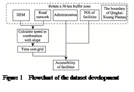 (1) Data collection and integration: Core datasets were
aggregated, including road networks, DEM, administrative boundaries, and POI
locations for public facilities;
(1) Data collection and integration: Core datasets were
aggregated, including road networks, DEM, administrative boundaries, and POI
locations for public facilities;
(2) Division of evaluation unit: A 30-km buffer
extending beyond the plateau??s boundary was applied to foundational datasets to
eliminate edge effects in route calculations, ensuring robust results within
the core study area;
(3) Generation of time cost grid: First, DEM-derived
slope values were classified into 4 topographic categories: plain (0%?C10%),
hill (10%?C25%), mountain (25%?C60%) and steep slope (more than 60%). The road
grade determines the upper limit of the speed, but the slope will affect the
actual road speed[11]. Road speeds, i.e., driving speed were
dynamically adjusted based on slope-road grade interactions (Table 2). The
speed of road class under the grade ?? was set at 10 km/h,
Roadless areas assumed a walking speed of 5 km/h. The two are combined to get
the total speed. Composite speed layers were converted to a unified m/s unit, enabling derivation of a second-per-grid-cell
time-cost raster;
Table
2 Speed
reclassification combined with slope
(Unit: km/h)
|
Slope grade
|
High way
|
Road Grade ??
|
Road Grade ??
|
Road Grade ??
|
Road Grade ??
|
|
Plain (0%?C10%]
|
120
|
80
|
80
|
60
|
30
|
|
Hill (10%?C25%]
|
100
|
60
|
60
|
50
|
25
|
|
Mountain (25%?C60%]
|
80
|
50
|
50
|
40
|
30
|
|
Steep slope (>60%)
|
60
|
40
|
40
|
30
|
15
|
(4) Calculation the accessibility of public facilities: The cost
distance tool in ArcGIS was employed to calculate the minimum travel time from
each township to the nearest public service facilities. POI locations
(including prefecture-level cities, counties, stores, banks, hospitals, and
junior high schools) and township centroids were loaded as target and source
features respectively. The time-cost grid (generated in
Step 3) was used as the friction surface. Results were exported with travel
time expressed in hours, rounded to 2 decimal places for consistency.
4 Data Results
4.1 Dataset Composition
The dataset on accessibility of public
service facilities among townships of Qinghai-Xizang Plateau includes a data
file in. shp format, in which the attribute fields ??city??, ??county??, ??store??,
??bank??, ??hospital?? and ??school?? are the shortest time from each township to the
nearest city, county, store, bank, hospital and junior high school,
respectively, the unit is h.
4.2 Data Results
The results of dataset show that
the accessibility of townships on the Qinghai-Xizang Plateau to all types of
essential service facilities averages approximately 1.5 h. Specifically, the
average travel times for townships to reach the nearest shops, banks, hospitals
and junior high schools is 1.45 h, 1.48 h, 2.13 h and 1.90 h, respectively. The
average travel times to prefecture-level cities and
counties are 5.52 h and 1.96 h, respectively.
Using the natural breaks classification method, accessibility to
various facilities was categorized into 5 levels, revealing distinct spatial
patterns (Figure 2). It is found that the overall accessibility is quite
different in regions. Within the jurisdiction of each city, all kinds of
accessibility are relatively good, and in the marginal areas of the county, all
kinds of accessibility are relatively poor.
Specifically, the accessibility to the city center shows a trend that
the accessibility around city is better (Figure 2), and the accessibility of
the fringe of the city and outside the city is getting worse. At the same time,
the border area of the Qinghai-Xizang Plateau is also accessible because it is
close to the urban areas outside the plateau. Because there is no subordinate
municipal district in Ngari Diqu (Region) in 2020, it is a area with poor
accessibility. The accessibility to the county is concentrated within 3.42 h,
and the city center and its adjacent areas are also good accessibility areas.
Due to the large area of some townships, the time for townships to reach the
county may be extended accordingly, such as Dongru Township in Rutog Xian (County)
in the north of Ngari Diqu (Region) and Rongma Township in Nyima Xian (County)
in the west of Nagqu Diqu (Region).
The time from most towns to the store is within 1.27 h, but it takes a
long time for some towns located in Gerze Xian (County) in the north of Ngari
in Xizang, Amdo Xian (County) and Shuanghu County in the north of Nagqu, Qiemo Xian
(County) and Ruoqiang Xian (County) in Bayingolin Mongolian Autonomous
Prefecture. The accessibility to the bank is concentrated within 2.95 h, which
is similar to the accessibility pattern to the store, showing that some areas
in northern Xizang and southern Xinjiang have poor accessibility.
The accessibility to hospitals is mostly within 4.05 h, showing a
pattern of good accessibility in the center of cities and counties and
relatively poor accessibility in the periphery, and the accessibility in parts
of northern Xizang and southern Xinjiang is also poor. The accessibility to
junior high schools is similar to that to hospitals, and the accessibility of
most townships is within 3.20 h.
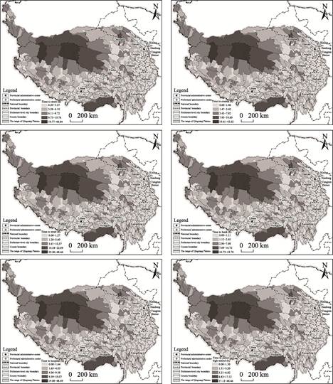
Figure
2 Maps of accessibility of
townships in the Qinghai-Xizang Plateau to prefecture-level cities, counties
and public service facilities
5 Discussion and Conclusion
Accessibility serves as a key indicator for public service facility
planning and development. The accessibility to urban centers (cities and
counties) and essential public facilities (including stores, banks, hospitals,
and junior high schools) significantly impacts both the daily convenience for
residents, and critical aspects such as emergency response capabilities and
equitable distribution of educational resources. This dataset is based on road
network data collected through the Second Tibetan Plateau Scientific Expedition
and Research (2019QZKK0406). It integrates DEM data to account for slope
effects and calculates accessibility to various facilities at the township
levels. This approach enhances data support for analyzing current
infrastructure distribution in the Qinghai-Xizang Plateau. Existing studies widely incorporate slope influence in
accessibility calculations[11?C13]. This dataset refines the
formula describing the relationship between slope and road speeds during
computation. Compared to accessibility results that disregard slope effects[6],
this dataset reveals longer time to the facility in steep-slope regions of the
plateau, such as its northern and northwestern areas. This outcome demonstrates
that omitting slope adjustments in accessibility models can lead to
overestimated results.
However, current analysis
focuses specifically on proximity to the nearest public service resources, the
location of public service resources closest to townships, without accounting
for variations in facility capacity or service quality. It should be noted that
actual utilization patterns for healthcare, education, or commercial services
may be influenced by these quality differentials. Future research building upon
this dataset could incorporate additional parameters such as hospital beds,
school levels, and retail market size to develop more comprehensive
accessibility metrics. Such enhanced datasets would enable more targeted
recommendations for facility upgrades and spatial optimization, ultimately
supporting continuous improvement of living standards across Qinghai-Xizang
Plateau.
Author Contributions
Guo, K. F. wrote this paper
and processed the data preliminarily. Dai, T. Q. made an overall design for the
development of the dataset; Zhang, L. L. completed the calculation of
accessibility of various facilities.
Conflicts
of Interest
The
authors declare no conflicts of interest.
References
[1]
Wang, J. E., Huang, J.
Theoretical innovation and practical application of transportation-region
development interactions [J]. Advances in Earth Science, 2022, 37(2):
177?C186.
[2]
Yang, F. L., Chen, L., Liu, Q.
Q., et al. An age-stratified study on the accessibility to sports venues
and their impact on resident satisfaction: evidence from urban Beijing [J]. Progress
in Geography, 2024, 43(7): 1416?C1428.
[3]
Huang, J. J., Lin, Y. T., Tao,
Z. L., et al. Evaluation of park green space accessibility in Shenzhen
from the perspective of social equity [J]. Scientia Geographica Sinica,
2022, 42(5): 896?C906.
[4]
Chen, Y., Zhang, L. L., Ma, R.
F., et al. Spatial match between urban residents?? distribution and green
space accessibility and its driving force [J]. Acta Ecologica Sinica,
2022, 42(24): 9971?C9980.
[5]
Lu, H. Y., Zhao, P. J., Dong,
Y. N., et al. Accessibility of high-speed rail stations and spatial
disparity of urban-rural income gaps [J]. Progress in Geography, 2022,
41(1): 131?C142.
[6]
Gao, X. C., Cao, X. S., Li, T.,
et al. Evolution of accessibility spatial pattern of the Qinghai-Xizang
Plateau in 1976?C2016 [J]. Acta Geographica Sinica, 2019, 74(6):
1190?C1204.
[7]
Guo, K. F., Dai, T, Q., Zhang,
L, L., Dataset on accessibility of public service facilities among townships of
Qingzang Plateau (2020) [J/DB/OL]. Digital Journal of Global Change Data
Repository, 2025. https://doi.org/10.3974/geodb.2025.03.04.V1.
[8]
GCdataPR Editorial Office.
GCdataPR data sharing policy [OL]. https://doi.org/10.3974/dp.policy.2014.05
(Updated 2017).
[9]
Zhang, Y. L., Li, B. Y., Zheng,
D. Datasets of the boundary and area of the Tibetan Plateau [J/DB/OL]. Digital
Journal of Global Change Data Repository, 2014. https://doi.org/
10.3974/geodb.2014.01.12.V1.
[10]
Zhang, Y. L., Li, B. Y., Zheng,
D. Datasets of the boundary
and area of the Tibetan Plateau [J]. Acta
Geographica Sinica. 2014, 69(Supplement): 164?C168.
[11]
Miao, Y., Lu, W. Q., Dai, T. Q,
et al. Comprehensive traffic advantage degree and its spatial
characteristics at the prefecture level on the Qinghai-Tibet Plateau: a case
study of Nyingchi City [J]. Progress in Geography, 2021, 40(8):
1332?C1343.
[12] Han, Z. G., Cui, C. H., Miao, C. H, et al. Spatial patterns of
multiscale accessibility in Henan Province??based on cost distance [J]. Journal
of Henan University (Natural Science), 2019, 49(2): 127?C136.
[13]
Hu, H. Y., Wang, L. J., Chen,
Y. L, et al. Accessibility and its spatial equity of basic education in
China [J]. Scientia Geographica Sinica, 2024, 44(9): 1513?C1523.