Dataset Development of the Forecasting Global Surface Soil
Moisture Using Multi-scenario Integration Methodology
(2015?C2100)
Yang, F. Liu, Y. X. Y.*
Institute of Geographic Sciences and Natural Resources
Research, Chinese Academy of Sciences, Beijing 100101, China
Abstract: Soil moisture is a
key land surface element to express the effects of global climate change. In
order to develop a reliable global future multi-scenario surface soil moisture
fusion dataset, this study firstly utilized the Enhanced Triple Collocation (ETC)
to evaluate the accuracy of 22 CMIP6 (Coupled Model Intercomparison Project
Phase 6) soil moisture datasets, and obtained the random error standard
deviation (RESD) and correlation coefficient (CC) to select the qualified Earth
System Model datasets. Secondly, 9 of the Earth System Model datasets were
fused based on the normalized weighting of RESD and CC. Finally, the accuracy
of the fused data was verified by the evaluation of the measured data at the
stations, and the results showed that the fused soil moisture data could
effectively describe the pattern of global surface soil moisture. The dataset
includes: (1) global monthly 0.5?? resolution soil moisture data of SSP1-2.6, SSP2-4.5, and SSP5-8.5.
(2) in situ measurements from 4 networks, which are NAQU, REMEDHUS,
SMOSMANIA, and TWENTE. The dataset is archived in .tif, .shp and .csv formats,
and consists of 3,124 data files with data size of 829 MB (compressed into 4
files with data size of 770 MB).
Keywords: surface soil moisture;
future multi-scenario; global; fusion
DOI: https://doi.org/10.3974/geodp.2025.02.03
Dataset Availability Statement:
The dataset supporting this paper
was published and is accessible through the Digital
Journal of Global Change Data Repository at:
https://doi.org/10.3974/geodb.2024.11.10.V1.
1 Introduction
Soil
moisture refers to water content stored in the unsaturated soil zone, and is a
physical quantity that indicates the degree of dryness or wetness of the soil.
Soil moisture is the link between the conversion of atmospheric water, surface
water, plant water and groundwater, and the carrier of material transfer,
playing an indispensable role in water and material cycles[1?C3].
Meanwhile, in the context of global warming caused by greenhouse gas emissions
from human activities, extreme weather events (e.g., high-temperature heat
waves, floods, and droughts) are frequently occurred. Permafrost in
high-latitude and high-altitude regions is ablated and degraded. And the
spatial and temporal distribution pattern of soil moisture changes
significantly, thus affecting the spatial and temporal evolution of the climate
and ecosystems[4,5]. Therefore,
obtaining reliable soil moisture data on a global scale and over a long time
series is of great scientific value and strategic significance for climate
change research, water cycle analysis, vegetation growth monitoring, early
warning of droughts and floods, and food security[6?C8].
The Coupled Model
Intercomparison Project Phase 6 (CMIP6), initiated by the World Climate
Research Program??s Working Group on Coupled Modelling, has provided a rich set
of coupled climate models for understanding future climate change[9,10].
The CMIP6 climate models have now become the basis for the United Nations
Intergovernmental Panel on Climate Change (IPCC) to prepare a report on future
climate change[11]. A series of
scenarios depicting different future socio-economic development patterns and
atmospheric greenhouse gas concentrations, called Shared Socioeconomic Pathways
(SSPs), have been constructed around CMIP6.
In order to enhance
the trend representativeness of the data and reduce anomaly bias, mainstream
studies usually simply calculate the ensemble mean of multiple future scenarios
to characterize the global future spatial-temporal distribution of soil moisture,
but they also face the risk of being dominated by the data with the largest
errors. In addition, although Earth System Models (ESM) continue to undergo
optimization iterations, systematic errors and uncertainties still exist at present[12]. In addition, there is an
urgent need to replace simple ensemble averaging with rational complementary
and optimal combinatorial fusion reconstruction of multi-source information to
improve the data reliability of soil moisture for future scenarios[13,14].
This dataset is
weighted and fused based on the accuracy spatial distribution characteristics
on the basis of evaluating multiple CMIP6 soil moisture. And it can provide
scientific data support for the study and analysis of the spatial-temporal
evolution pattern of the future surface water cycle.
2 Metadata of the Dataset
The
metadata of Forecasting global surface soil moisture dataset using
multi-scenario integration methodology (2015?C2100)[15]
is summarized in Table 1. It includes the dataset full name, short name,
authors, year of the dataset, temporal resolution, spatial resolution, data
format, data size, data files, data publisher, and data sharing policy, etc.
3 Methods
3.1 Data Sources
The CMIP6 surface (0?C10 cm) soil moisture data[11] used in this dataset
consisted of 3 main SSPs, which are SSP1-2.6 (Sustainable Pathway), SSP2-4.5
(Medium Pathway), and SSP5-8.5 (Fossil Fuel Burning Pathway). The soil moisture
data involved in the evaluation and fusion were derived from 22 Earth system
models, namely ACCESS-CM2, BCC-CSM2-MR, CAMS-CSM1-0, CanESM5-CanOE, CESM2,
CMCC-CM2-SR5, CMCC- ESM2, CNRM-CM6-1, and CNRM-CM6-1-HR, CNRM-ESM2-1,
EC-Earth3-Veg-LR,
Table 1 Metadata summary of the Forecasting global surface
soil moisture dataset using multi-scenario integration methodology (2015?C2100)
|
Items
|
Description
|
|
Dataset full name
|
Forecasting global surface soil moisture
dataset using multi-scenario integration methodology (2015?C2100)
|
|
Dataset short name
|
MonthlyinsituData
|
|
Authors
|
Yang, F., Institute of Geographic Sciences
and Natural Resources Research, Chinese Academy of Sciences,
yangf@igsnrr.ac.cn
Liu, Y. X. Y., Institute of Geographic
Sciences and Natural Resources Research, Chinese Academy of Sciences,
lyxy@lreis.ac.cn
|
|
Geographical region
|
Global (90??N?C60??S)
|
|
Year
|
2015?C2100
|
|
Temporal resolution
|
monthly
|
|
Spatial resolution
|
0.5????0.5??
|
|
Data format
|
.tif, .shp, .csv
|
|
|
|
Data size
|
770 MB (compressed)
|
|
|
|
Data files
|
(1) Global monthly 0.5?? resolution soil
moisture data if SSP1-2.6, SSP2-4.5, and SSP5-8.5; (2) In situ
measurements from 4 networks, which are NAQU, REMEDHUS, SMOSMANIA, and TWENTE
|
|
Foundation
|
National Natural
Science Foundation of China (42101475)
|
|
Data publisher
|
Global Change
Research Data Publishing & Repository, http://www.geodoi.ac.cn
|
|
Address
|
No. 11A, Datun Road, Chaoyang District,
Beijing 100101, China
|
|
Data sharing policy
|
(1) Data
are openly available and can be free downloaded via the Internet; (2) End
users are encouraged to use Data
subject to citation; (3) Users, who are by definition also value-added
service providers, are welcome to redistribute Data subject to written permission from the GCdataPR Editorial
Office and the issuance of a Data
redistribution license; and (4) If Data
are used to compile new datasets, the ??ten percent principal?? should be
followed such that Data records
utilized should not surpass 10% of the new dataset contents, while sources
should be clearly noted in suitable places in the new dataset[16]
|
|
Communication
and searchable system
|
DOI, CSTR, Crossref, DCI, CSCD, CNKI,
SciEngine, WDS, GEOSS, PubScholar, CKRSC
|
GFDL-ESM4,
IPSL-CM6A-LR, KACE-1-0-G, MIROC6, MIROC-ES2L, MPI-ESM1-2-LR, MRI-ESM2-0,
NorESM2-LM, NorESM2-MM, TaiESM1, UKESM1-0-LL.
In addition,
this study used SMAP (Soil Moisture Active Passive) soil moisture data[17], ERA5-Land (Medium-Range
Weather Forecast Reanalysis v5-Land) surface soil moisture data[18],
and International Soil Moisture Monitoring Network data[19]
as auxiliary data for evaluation and validation.
3.2 Technological Route
This
study is aimed to obtain stable and reliable CMIP6 soil moisture fusion data
products. First, all raster data were converted to TIF format, with the spatial
resolution unified to 0.5????0.5?? and the temporal resolution unified to the
monthly scale. Second, the SMAP and ERA5-Land soil moisture data were used to
perform a quality evaluation of the CMIP6 soil moisture data using the ETC
method (Enhanced Triple Collocation) to obtain the Random Error Standard
Deviation (RESD) and Correlation Coefficient (CC). Third, based on the quality
evaluation results, CMIP6 Earth system model data with better accuracy were
screened out, and the spatial distribution of the accuracy of each data was
combined to calculate the summation and normalization weights, and then fusion
was carried out on the basis of the summation and normalization weights.
Fourth, the accuracy level of the fused data was verified and evaluated by the
ground-based data. Bias, Root Mean Square Error (RMSE) and goodness of fit (R)
are selected as the error parameters to systematically verify the accuracy of
the fused data. At the same time, the evaluation and verification results of
the simple weighted average fused data are calculated as a reference. The
specific data development process is shown in Figure 1.
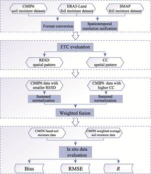
Figure 1 Flowchart of the dataset
development
As shown in
Table 2, the mean value of soil moisture data evaluation of each Earth system
model was first calculated. ACCESS-CM2, IPSL-CM6A-LR, MIROC-ES2L,
MPI-ESM1-2-LR, TaiESM1 with smaller RESD, and CanESM5-CanOE, CMCC-CM2-SR5, CNRM-CM6-1-HR, and KACE-1-0-G with
higher CC were screened out. Finally, 9 Earth system model soil moisture
datasets were involved in the fusion.
Table 2 Evaluated mean values of soil moisture
data for each Earth system model
|
ESM
|
RESD (m3/m3)
|
CC
|
ESM
|
RESD (m3/m3)
|
CC
|
|
ACCESS-CM2
|
0.026
|
0.465
|
GFDL-ESM4
|
0.032
|
0.479
|
|
BCC-CSM2-MR
|
0.030
|
0.457
|
IPSL-CM6A-LR
|
0.026
|
0.486
|
|
CAMS-CSM1-0
|
0.033
|
0.460
|
KACE-1-0-G
|
0.069
|
0.515
|
|
CanESM5-CanOE
|
0.048
|
0.501
|
MIROC-ES2L
|
0.029
|
0.473
|
|
CESM2
|
0.048
|
0.495
|
MIROC6
|
0.030
|
0.486
|
|
CMCC-CM2-SR5
|
0.044
|
0.523
|
MPI-ESM1-2-LR
|
0.026
|
0.458
|
|
CMCC-ESM2
|
0.044
|
0.524
|
MRI-ESM2-0
|
0.036
|
0.479
|
|
CNRM-CM6-1
|
0.036
|
0.499
|
NorESM2-LM
|
0.047
|
0.491
|
|
CNRM-CM6-1-HR
|
0.036
|
0.501
|
NorESM2-MM
|
0.047
|
0.498
|
|
CNRM-ESM2-1
|
0.036
|
0.503
|
TaiESM1
|
0.030
|
0.499
|
|
EC-Earth3-Veg-LR
|
0.046
|
0.470
|
UKESM1-0-LL
|
0.039
|
0.494
|
4 Data Results and Validation
4.1 Dataset Composition
The
main contents of the datasets include: (1) Global soil moisture data, with a
temporal range from January 2015 to December 2100 and a spatial range covering
the globe, with a temporal resolution on a monthly scale and a spatial
resolution of 0.5????0.5??. The data unit is m3/m3 and the
data value range is 0 to 1. The file naming scheme is SSP***_yyyy-mm.tif. (2) In
situ measurements of NAQU, REMEDHUS, SMOSMANIA, and TWENTE networks. The
above-mentioned datasets are archived in .tif, .shp, and .csv, which have 3,124
files in total.
4.2 Data Products
Figure
2 shows the soil moisture data of the fused CMIP6 under the 3 shared
socio-economic path modes of SSP1-2.6, SSP2-4.5, and SSP5-8.5. The January,
April, July, and October of 2030 are used as the samples of the fused soil
moisture product of CMIP6 to present 4 seasons of winter, spring, summer, and
autumn. As can be seen from the figure, the spatial and temporal distribution
pattern of CMIP6 fused soil moisture is characterized by a more consistent
climate seasonal rhythm cycle. The data were filtered using water mask to
exclude rivers, lakes, glaciers and other terrestrial water bodies to guarantee
the reasonableness.
4.3 Data Validation
In
order to quantitatively evaluate the accuracy of CMIP6 soil moisture fusion
data, this study selected and collected data from 4 ground-based soil moisture
monitoring networks with long-term monitoring capabilities, including NAQU
(located in the Nagqu region of the Qinghai-Xizang Plateau), REMEDHUS (located
in Spain), SMOSMANIA (located in France) and TEWNTE (located in the
Netherlands), to evaluate the accuracy of the fusion data during 2015?C2024.
Given that ground station measured data mostly provide hourly surface soil
moisture data, the hourly data were first synthesized into daily scale data and
then into monthly scale data. In order to guarantee the data quality, stability
and representativeness, it was set that monitoring data of not less than 12
hours in a day could be weighted to calculate daily-scale data, and monitoring
data of not less than 15 days in a month could be weighted to calculate
monthly-scale data. At the same time, the weighted average of 22 CMIP6 soil
moisture datasets were calculated as a reference.
As shown in Table 3,
the CMIP6 soil moisture fusion data has significant advantages in numerical
accuracy (Bias and RMSE) compared with the weighted average data, revealing the
accuracy improvement effect of normalized fusion based on the spatial
distribution data of ETC accuracy. The CMIP6 soil moisture fusion data can be
comparable to the weighted average data in terms of the accuracy of the fusion
data in terms of R. It could be able to reasonably depict the textural
characteristics of the spatial and temporal distribution of soil moisture on
the ground, and reasonably fit the measured soil moisture values on the ground.
5 Discussion and Conclusion
Soil moisture is an
important component of the surface water cycle system, and the
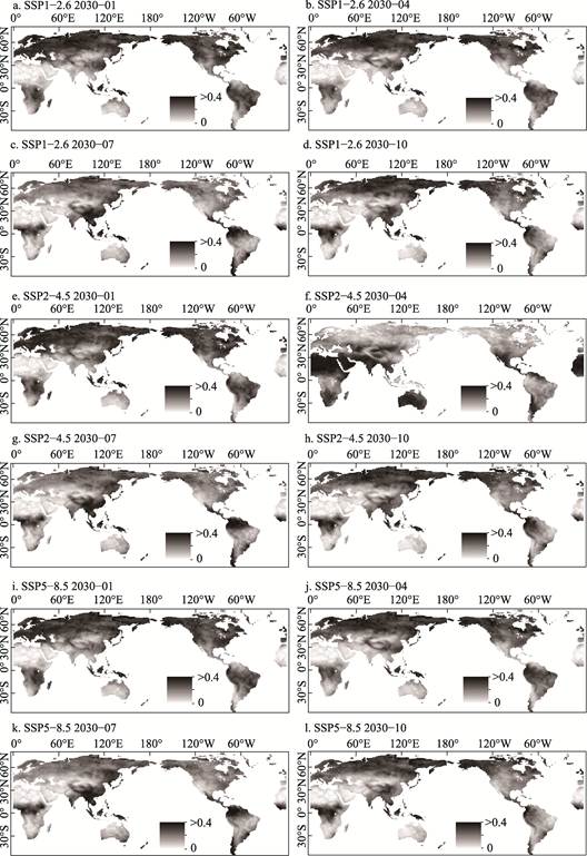
Figure 2 Maps of soil moisture integration data
for SSP1-2.6, SSP2-4.5, and SSP5-8.5 in January, April, July, and October 2030
Table 3 CMIP6 soil moisture fusion data accuracy
evaluation results
|
Soil
moisture monitoring network
|
Evaluation
metrics
|
Fusion data
|
Weighted
average data
|
|
SSP1-2.6
|
SSP2-4.5
|
SSP5-8.5
|
SSP1-2.6
|
SSP2-4.5
|
SSP5-8.5
|
|
NAQU
|
Bias (m3/m3)
|
0.043
|
0.042
|
0.040
|
0.081
|
0.087
|
0.083
|
|
RMSE (m3/m3)
|
0.055
|
0.055
|
0.054
|
0.091
|
0.096
|
0.092
|
|
R
|
0.779
|
0.766
|
0.757
|
0.685
|
0.703
|
0.737
|
|
REMEDUHS
|
Bias (m3/m3)
|
0.107
|
0.107
|
0.104
|
0.140
|
0.138
|
0.136
|
|
RMSE (m3/m3)
|
0.117
|
0.119
|
0.116
|
0.147
|
0.146
|
0.145
|
|
R
|
0.747
|
0.708
|
0.710
|
0.731
|
0.714
|
0.712
|
|
SMOSMANIA
|
Bias (m3/m3)
|
0.032
|
0.029
|
0.027
|
0.054
|
0.051
|
0.050
|
|
RMSE (m3/m3)
|
0.084
|
0.084
|
0.083
|
0.092
|
0.092
|
0.091
|
|
R
|
0.681
|
0.682
|
0.673
|
0.696
|
0.679
|
0.688
|
|
TWENTE
|
Bias (m3/m3)
|
0.168
|
0.163
|
0.169
|
0.214
|
0.211
|
0.214
|
|
RMSE (m3/m3)
|
0.174
|
0.170
|
0.176
|
0.218
|
0.215
|
0.218
|
|
R
|
0.587
|
0.593
|
0.545
|
0.570
|
0.602
|
0.561
|
acquisition
of reliable global soil moisture data of long time series is a key support for
understanding the water cycle pattern. In the context of global climate change,
obtaining reliable soil moisture data for future scenarios is essential to
accurately study and explore the evolutionary characteristics of the spatial
and temporal distribution of water resources. In this study, from the
perspective of data fusion, multiple sets of CMIP6 future soil moisture data
were normalized and weighted with the corresponding precision spatial
distribution data on the basis of ETC evaluation, and got a global
monthly-scale 0.5????0.5?? resolution surface soil moisture dataset from 2015 to
2100. As verified by the measured data at the site, the fusion data has
significantly lower Bias and RMSE than the simple weighted average data,
indicating that the fusion data can effectively improve the accuracy and
reliability.
This dataset, as
a global surface future soil moisture dataset, can be used as a reference basis
for the study of climate change, ecological risk and in-depth understanding of
the spatial and temporal evolution of soil moisture. Meanwhile, it provides a scientific
data basis for revealing the simulation of the migration of soil moisture on
the surface, and auxiliary decision-making support for understanding and coping
with the evolution of the imbalanced distribution of surface water resources,
and for sustainable development of surface water resources.
Author Contributions
Yang, F. did the overall
design for the development of the dataset, collected and processed all the
data; Liu, Y. X. Y. wrote the data paper.
Conflicts of Interest
The authors
declare no conflicts of interest.
References
[1]
Zhou, C. H., Yu, J. J. Review
and prospect of hydrography research in China [J]. Journal of Geography, 2023, 78(7): 1659?C1665.
[2]
Liu, Y. X. Y., Yang, Y. P. A
review of the progress in fusing large-scale regional soil moisture datasets
with multi-source microwave remote sensing [J]. Frontiers in Data and Computing Development, 2023, 4(6): 24?C33.
[3]
Pan, N., Wang, S., Liu, Y. X., et al. Advances in soil moisture remote
sensing inversion research [J]. Journal
of Ecology, 2019, 39(13): 4615?C4626.
[4]
Xie, Z. H., Chen, S., Qin, P.
H., et al. Research on climate
feedbacks of human water use activities and their impacts on the terrestrial
water cycle: progress and challenges [J]. Advances
in Earth Sciences, 2019, 34(8): 801?C813.
[5]
Liu, C. M., Liu, X. M.
Exploring water cycle research from the perspective of Earth system circle
mutual feedbacks and geographic synthesis [J]. Journal of Geography, 2023, 78(7): 1593?C1598.
[6]
Li, Z., Guo, H. D., Shi, J. C.
Integrating active and passive microwave data for monitoring soil moisture
changes [J]. Journal of Remote Sensing,
2002, 6(6): 481?C484.
[7]
Ma, Z. G., Fu, Z. B., Xie, L., et al. Some issues in the study of soil
moisture and climate change relationships [J]. Advances in Earth Sciences, 2001, 16(4): 563?C568.
[8]
Liu, Y. X. Y., Yang, Y. P.,
Song, J. Variations in global soil moisture during the past decades: climate or
human causes? [J]. Water Resources
Research, 2023, 59(7): e2023WR034915.
[9]
Zhou, T. J., Zou, L. W., Chen,
X. L. Review of the Sixth International Coupled Model Intercomparison Program
(CMIP6) [J]. Advances in Climate Change
Research, 2019, 15(5): 445?C456.
[10]
Wang, Y. N., Qiao, L., Zuo, Z.
Y. Review of the CMIP6 Land Surface, Snow, and Soil Moisture Model Comparison
Program (LS3MIP) [J]. Advances in Climate
Change Research, 2022, 18(6): 795?C800.
[11]
Jiang, D. B., Wang, N.
Interpretation of the IPCC AR6 report: changes in the water cycle [J]. Progress in Climate Change Research,
2021, 17(6): 699?C704.
[12]
Liu, Y. X. Y., Chen, X. N.,
Bai, Y. Q., et al. Evaluation of 22
CMIP6 model-derived global soil moisture products of different shared
socioeconomic pathways [J]. Journal of
Hydrology, 2024, 636: 131241.
[13]
Li, Z. L., Leng, P., Zhou, C.
H., et al. Soil moisture retrieval
from remote sensing measurements: current knowledge and directions for the
future [J]. Earth-Science Reviews,
2021, 218(1): 1?C24.
[14]
Qiao, L., Zuo, Z. Y., Xiao, D.
Evaluation of soil moisture in CMIP6 simulations [J]. Journal of Climate,
2022, 35(2): 779?C800.
[15]
Yang, F., Liu, Y. X. Y. Forecasting
global surface soil moisture dataset using multi-scenario integration methodology
(2015?C2100) [J/DB/OL]. Digital Journal of Global Change Data Repository, 2024. https://doi.org/10.3974/geodb.2024.11.10.V1.
[16] GCdataPR Editorial Office. GCdataPR data sharing policy [OL].
https://doi.org/10.3974/dp.policy.2014.05 (Updated 2017).
[17]
Spencer, M., Wheeler, K.,
White, C., et al. The Soil Moisture Active Passive (SMAP) mission L-Band
radar/radiometer instrument [J]. IEEE,
2010: 3240?C3243.
[18]
Muñoz-Sabater, J., Dutra, E.,
Agust??-Panareda, A., et al.
ERA5-Land: a state-of-the-art global reanalysis dataset for land applications
[J]. Earth System Science Data, 2021,
13(9): 4349?C4383.
[19] Dorigo, W. A., Wagner, W., Hohensinn, R., et al. The
International Soil Moisture Network: a data hosting facility for global in
situ soil moisture measurements [J]. Hydrology
and Earth System Sciences, 2011, 15(5): 1675?C1698.