Global Change Data Encyclopedia
Outer Hebrides
Zhang, Y. H.* Liu, C. Shi, R. X.
Institute of Geographic Sciences and Natural Resources
Research, Chinese Academy of Sciences, Beijing 100101, China
Keywords: Outer Hebrides;
Atlantic; Scotland; Minch Channel; Western Isles; data encyclopedia
Dataset Available Statement:
The dataset supporting this paper
was published at: Zhang, Y. H., Liu, C., Shi, R. X. Outer Hebrides [J/DB/OL]. Digital Journal of Global Change Data
Repository, 2020. DOI: 10.3974/geodb.2020.03.12.V1.
Outer Hebrides, off the
northwestern coast of the Scotland extending in the Atlantic, is comprised in
the Western Isles. The Outer Hebrides are separated from the Inner Hebrides by
the Minch and Little Minch channels in the north and by the Sea of the Hebrides
in the south. The Outer Hebrides lies in a crescent about 65 km from the
Scottish mainland and its geo-location is 56??46??38??N-59??8??4??N, 8??39??1??W-5??48??37??W[1?C6]
(Figure 1-2).
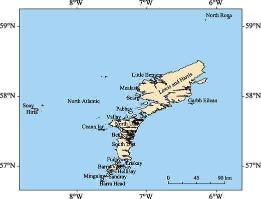
Figure 1 Map of the Outer Hebrides (.shp format)
|
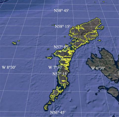
Figure 2 Map
of the Outer Hebrides (.kmz format)
|
Outer Hebrides mainly consists
of Lewis and Harris, North Uist, South Uist, Benbecula and Barra-Vatersay[7]. There are 2,413 islands
and islets with area bigger than 25 m2 in the Outer Hebrides. Lewis
and Harris with area of 2,169.36 km2 and coastline of 934.16 km is
the largest and most northerly of the Outer Hebrides islands, lying 39 km from
the west coast of the Scottish mainland and separated from it by the Minch
channel. The North Usit is joined by constructed causeways with the Baleshare island in the northeast and with the Berneray island in the
south. The Benbecula is similarly connected with the Eileann Chearabhaigh island in the north and the Flodaigh island in the south.
Other larger islands include Great Bernera, Grimsay-Ronay, Taransay, Scarp,
Pabbay, Isle of Scalpay, Eriskay, Hirta, Mingulay, Sandray, Wiay, Vallay, Ceann
Ear, Boreray, Seaforth, Pabbay, Fuday, Barra Head, Ensay, Kirkbost, Killegray,
Ceann Iar, Garbh Eilean, Hellisay, Ceallasaigh Mor-Beag, Eilean Iubhard,
Mealasta, Little Bernera, North Rona, Soay, Gighay, Stromay, Pabaigh Mor, etc. (Table 1). The total area of the Outer Hebrides is
3,184.85 km2 and the total length of its coastline is 3,401.72 km.
Table 1 Geolocation,
area and coastline of main islands of the Outer Hebrides
|
Name of island
|
Geolocation
|
Centroid of island
|
Area (km2)
|
Coastline (km)
|
|
Lewis and Harris
|
57??43??39??N?C58??30??59??N,
7??8??11??W?C6??8??6??W
|
58??7??59??N,
6??39??31??W
|
2,169.36
|
934.16
|
|
North
Uist
|
57??29??49??N?C57??44??22??N,
7??32??59??W?C7??3??46??W
|
57??36??6??N,
7??17??23??W
|
337.69
|
438.12
|
|
South
Uist
|
57??5??43??N?C57??25??5??N,
7??27??35??W?C7??11??31??W
|
57??15??2??N,
7??19??52??W
|
321.23
|
248.92
|
|
Benbecula
|
57??23??15??N?C57??29??39??N,
7??24??53??W?C7??11??49??W
|
57??26??40??N,
7??18??32??W
|
86.35
|
177.50
|
|
Barra?CVatersay
|
56??54??31??N?C57??3??33??N,
7??34??58??W?C7??22??30??W
|
56??58??42??N,
7??28??43??W
|
72.62
|
125.82
|
(To be continued on the next page)
(Continued)
|
Name of island
|
Geolocation
|
Centroid of island
|
Area (km2)
|
Coastline (km)
|
|
Great
Bernera
|
58??12??1??N?C58??15??38??N,
6??53??37??W?C6??46??55??W
|
58??13??40??N,
6??50??27??W
|
21.23
|
50.16
|
|
Grimsay?CRonay
|
57??28??7??N?C57??30??23??N,
7??17??29??W?C7??9??27??W
|
57??29??22??N,
7??12??57??W
|
15.61
|
64.48
|
|
Taransay
|
57??52??29??N?C57??55??19??N,
7??5??24??W?C6??59??15??W
|
57??53??56??N,
7??1??45??W
|
14.62
|
26.33
|
|
Scarp
|
58??0??9??N?C58??2??18??N,
7??10??21??W?C7??5??56??W
|
58??1??15??N,
7??7??59??W
|
10.63
|
18.64
|
|
Pabbay
|
57??45??32??N?C57??47??8??N,
7??16??5??W?C7??11??56??W
|
57??46??21??N,
7??13??58??W
|
8.20
|
12.47
|
|
Isle
of Scalpay
|
57??50??59??N?C57??52??46??N,
6??42??51??W?C6??38??26??W
|
57??51??53??N,
6??40??33??W
|
7.77
|
26.06
|
|
Eriskay
|
57??3??9??N?C57??5??55??N,
7??19??20??W?C7??16??6??W
|
57??4??29??N,
7??17??35??W
|
7.70
|
22.68
|
|
Hirta
|
57??47??37??N?C57??49??43??N,
8??37??6??W?C8??32??58??W
|
57??48??51??N,
8??35??1??W
|
7.17
|
19.82
|
|
Mingulay
|
56??47??46??N?C56??49??51??N,
7??39??58??W?C7??37??3??W
|
56??48??42??N,
7??38??24??W
|
6.65
|
19.38
|
|
Sandray
|
56??52??48??N?C56??54??9??N,
7??32??25??W?C7??29??21??W
|
56??53??33??N,
7??30??58??W
|
4.57
|
13.92
|
|
Wiay
|
57??23??7??N?C57??24??41??N,
7??14??3??W?C7??11??12??W
|
57??23??52??N,
7??12??33??W
|
4.40
|
22.85
|
|
Vallay
|
57??39??12??N?C57??40??13??N,
7??26??39??W?C7??22??23??W
|
57??39??45??N,
7??24??21??W
|
3.21
|
14.86
|
|
Ceann
Ear
|
57??30??32??N?C57??32??1??N,
7??37??52??W?C7??35??45??W
|
57??31??18??N,
7??36??48??W
|
2.69
|
15.79
|
|
Boreray
|
57??41??59??N?C57??43??12??N,
7??18??8??W?C7??16??26??W
|
57??42??38??N,
7??17??18??W
|
2.63
|
6.99
|
|
Seaforth
|
57??59??8??N?C58??0??30??N,
6??44??28??W?C6??42??45??W
|
57??59??51??N,
6??43??34??W
|
2.60
|
6.81
|
|
Pabbay
|
56??50??50??N?C56??51??44??N,
7??35??54??W?C7??32??56??W
|
56??51??14??N,
7??34??36??W
|
2.58
|
13.65
|
|
Fuday
|
57??2??32??N?C57??3??45??N,
7??24??14??W?C7??22??16??W
|
57??3??6??N,
7??23??17??W
|
2.51
|
7.74
|
|
Barra
Head
|
56??46??40??N?C56??47??24??N,
7??39??39??W?C7??36??42??W
|
56??47??6??N,
7??38??12??W
|
2.23
|
8.77
|
|
Ensay
|
57??45??4??N?C57??46??31??N,
7??5??55??W?C7??4??14??W
|
57??45??48??N,
7??4??58??W
|
2.08
|
7.83
|
|
Kirkbost
|
57??32??57??N?C57??34??11??N,
7??26??23??W?C7??24??7??W
|
57??33??28??N,
7??25??29??W
|
2.02
|
7.26
|
|
Killegray
|
57??43??54??N?C57??44??60??N,
7??5??49??W?C7??3??28??W
|
57??44??25??N,
7??4??51??W
|
2.00
|
9.27
|
|
Ceann
Iar
|
57??31??5??N?C57??32??10??N,
7??41??4??W?C7??38??23??W
|
57??31??33??N,
7??39??36??W
|
2.00
|
14.60
|
|
Garbh
Eilean
|
57??52??45??N?C57??54??19??N,
6??22??54??W?C6??20??53??W
|
57??53??44??N,
6??21??38??W
|
1.65
|
9.82
|
|
Hellisay
|
57??0??21??N?C57??1??10??N,
7??21??50??W?C7??19??42??W
|
57??0??48??N,
7??20??46??W
|
1.60
|
8.35
|
|
Ceallasaigh
Mor?CBeag
|
57??37??12??N?C57??38??20??N,
7??11??50??W?C7??9??7??W
|
57??37??49??N,
7??10??20??W
|
1.55
|
18.97
|
|
Eilean
Iubhard
|
57??59??48??N?C58??0??20??N,
6??27??4??W?C6??24??44??W
|
58??0??4??N,
6??25??51??W
|
1.40
|
7.45
|
|
Mealasta
|
58??4??18??N?C58??5??15??N,
7??8??26??W?C7??7??1??W
|
58??4??47??N,
7??7??36??W
|
1.40
|
8.95
|
|
Little
Bernera
|
58??15??34??N?C58??16??17??N,
6??53??23??W?C6??51??25??W
|
58??15??54??N,
6??52??27??W
|
1.34
|
7.54
|
|
North
Rona
|
59??7??1??N?C59??8??4??N,
5??50??27??W?C5??48??43??W
|
59??7??24??N,
5??49??31??W
|
1.25
|
8.96
|
|
Soay
|
57??49??23??N?C57??50??4??N,
8??39??1??W?C8??37??26??W
|
57??49??44??N,
8??38??7??W
|
1.22
|
5.14
|
|
Stromay
|
57??39??4??N?C57??39??54??N,
7??8??58??W?C7??7??35??W
|
57??39??27??N,
7??8??14??W
|
1.04
|
7.89
|
(To be
continued on the next page)
(Continued)
|
Name of island
|
Geolocation
|
Centroid of island
|
Area (km2)
|
Coastline (km)
|
|
Gighay
|
57??0??49??N?C57??1??36??N,
7??20??52??W?C7??19??11??W
|
57??1??13??N,
7??19??53??W
|
1.11
|
6.16
|
|
Pabaigh
Mor
|
58??13??41??N?C58??14??29??N,
6??57??5??W?C6??55??43??W
|
58??14??5??N,
6??56??24??W
|
1.04
|
7.03
|
|
Boreray
|
57??51??47??N?C57??52??38??N,
8??30??1??W?C8??28??48??W
|
57??52??11??N,
8??29??23??W
|
1.02
|
4.36
|
|
Fuaigh
Mor
|
58??12??15??N?C58??13??11??N,
6??53??51??W?C6??52??38??W
|
58??12??37??N,
6??53??22??W
|
0.94
|
5.55
|
|
Fuiay
|
56??59??28??N?C57??0??4??N,
7??22??50??W?C7??21??37??W
|
56??59??47??N,
7??22??10??W
|
0.89
|
4.17
|
|
Muldoanich
|
56??54??38??N?C56??55??21??N,
7??27??6??W?C7??26??8??W
|
56??55??2??N,
7??26??38??W
|
0.87
|
4.46
|
|
Hermetray
|
57??39??0??N?C57??39??46??N,
7??3??37??W?C7??2??36??W
|
57??39??22??N,
7??3??4??W
|
0.85
|
5.88
|
|
Eilean
Chearstaidh
|
58??11??35??N?C58??12??24??N,
6??46??41??W?C6??45??50??W
|
58??12??1??N,
6??46??14??W
|
0.78
|
3.68
|
|
Stockinish
|
57??48??9??N?C57??48??50??N,
6??49??47??W?C6??48??25??W
|
57??48??29??N,
6??49??10??W
|
0.71
|
5.32
|
|
Eileanan
Iasgaich
|
57??8??30??N?C57??8??59??N,
7??19??39??W?C7??17??59??W
|
57??8??39??N,
7??18??24??W
|
0.65
|
5.85
|
|
Tahay
|
57??39??30??N?C57??40??5??N,
7??6??13??W?C7??5??10??W
|
57??39??46??N,
7??5??40??W
|
0.63
|
3.68
|
|
Flodaigh
Mor
|
57??29??42??N?C57??30??12??N,
7??9??50??W?C7??8??37??W
|
57??29??58??N,
7??9??18??W
|
0.62
|
4.62
|
|
Shillay
|
57??31??22??N?C57??32??4??N,
7??41??54??W?C7??40??48??W
|
57??31??43??N,
7??41??22??W
|
0.59
|
3.77
|
|
Soay
Mor
|
57??55??57??N?C57??56??37??N,
6??58??25??W?C6??57??21??W
|
57??56??16??N,
6??57??51??W
|
0.58
|
4.72
|
|
Stuley
|
57??11??15??N?C57??11??44??N,
7??15??22??W?C7??14??24??W
|
57??11??29??N,
7??14??55??W
|
0.56
|
3.39
|
|
Sgeotasaigh
|
57??52??15??N?C57??52??46??N,
6??45??20??W?C6??44??15??W
|
57??52??32??N,
6??44??50??W
|
0.55
|
3.64
|
|
Fiaraidh
|
57??3??46??N?C57??4??8??N,
7??27??6??W?C7??26??2??W
|
57??3??57??N,
7??26??36??W
|
0.47
|
3.43
|
|
Flodday
|
56??59??36??N?C56??59??60??N,
7??21??32??W?C7??20??31??W
|
56??59??47??N,
7??21??1??W
|
0.46
|
4.04
|
|
Vacsay
|
58??13??24??N?C58??13??55??N,
6??55??23??W?C6??54??36??W
|
58??13??38??N,
6??54??58??W
|
0.44
|
5.40
|
|
Flodaigh
|
58??11??22??N?C58??11??56??N,
6??56??4??W?C6??55??15??W
|
58??11??38??N,
6??55??38??W
|
0.42
|
3.48
|
|
Floadday
|
56??53??28??N?C56??54??5??N,
7??34??20??W?C7??33??44??W
|
56??53??48??N,
7??34??3??W
|
0.38
|
3.64
|
|
Lingeigh
|
56??52??13??N?C56??52??38??N,
7??34??53??W?C7??34??19??W
|
56??52??25??N,
7??34??36??W
|
0.32
|
2.32
|
|
Fuaigh
Beag
|
58??11??34??N?C58??11??59??N,
6??54??12??W?C6??53??36??W
|
58??11??46??N,
6??53??55??W
|
0.31
|
2.50
|
|
Sibhinis
|
57??31??6??N?C57??31??33??N,
7??38??24??W?C7??37??49??W
|
57??31??19??N,
7??38??7??W
|
0.30
|
2.74
|
|
Haskeir
|
57??41??51??N?C57??42??15??N,
7??41??32??W?C7??40??46??W
|
57??41??57??N,
7??41??9??W
|
0.20
|
3.43
|
|
Flodaigh
|
58??15??53??N?C58??16??11??N,
6??54??51??W?C6??54??14??W
|
58??16??2??N,
6??54??30??W
|
0.18
|
2.64
|
|
Cealasaigh
|
58??16??11??N?C58??16??33??N,
6??52??34??W?C6??52??3??W
|
58??16??22??N,
6??52??17??W
|
0.15
|
2.41
|
|
Seanna
Chnoc
|
58??16??57??N?C58??17??8??N,
6??55??31??W?C6??54??55??W
|
58??17??2??N,
6??55??13??W
|
0.14
|
2.11
|
|
Sula
Sgeir
|
59??5??33??N?C59??5??56??N,
6??9??39??W?C6??9??4??W
|
59??5??44??N,
6??9??22??W
|
0.12
|
2.31
|
|
Bearasaigh
|
58??16??30??N?C58??16??45??N,
6??54??58??W?C6??54??27??W
|
58??16??37??N,
6??54??44??W
|
0.12
|
2.13
|
|
Stocaigh
|
57??31??51??N?C57??32??12??N,
7??35??13??W?C7??34??44??W
|
57??32??2??N,
7??34??57??W
|
0.10
|
2.60
|
(To be
continued on the next page)
(Continued)
|
Name of island
|
Geo-location
|
Centroid of island
|
Area (km2)
|
Coastline (km)
|
|
Campaigh
|
58??16??37??N?C58??16??51??N,
6??52??48??W?C6??52??23??W
|
58??16??44??N,
6??52??36??W
|
0.10
|
1.38
|
|
Deasker
|
57??33??48??N?C57??33??59??N,
7??36??57??W?C7??36??40??W
|
57??33??54??N,
7??36??48??W
|
0.08
|
1.06
|
|
Stac
an Armin
|
57??52??43??N?C57??52??58??N,
8??29??53??W?C8??29??37??W
|
57??52??49??N,
8??29??46??W
|
0.08
|
1.13
|
|
Stac
Lee
|
57??51??56??N?C57??51??59??N,
8??30??45??W?C8??30??27??W
|
57??51??58??N,
8??30??35??W
|
0.01
|
0.63
|
The dataset
was developed based on the Google Earth and related
maps and references[3-7]. The dataset is consisted
of 15 data files and archived in the .kmz and .shp[8]
data formats with the data size of 27.7 MB (Compressed to 11.7 MB in two files).
References
[1]
Outer Hebrides [OL]. Encyclopedia
Britannica, Encyclopedia Britannica Inc., 16 Nov., 2010.
https://www.britannica.com/place/Outer-Hebrides.
[2]
Western
Isles [OL]. Encyclopedia Britannica, Encyclopedia Britannica Inc., 16 May., 2018. https://www.britannica.com/place/Western-Isles.
[3]
Sino Maps Press. United Kingdom
Atlas [M]. Beijing: Sino Maps Press, 2007.
[4]
Liu, C., Shi, R. X., Zhang, Y.
H., et al. Global multiple scale
shorelines dataset based on Google Earth images (2015) [DB/OL]. Global Change
Data Repository, 2019. DOI: 10.3974/geodb.2019.04.13.V1.
[5]
Liu, C., Zhang, Y. H., Shi, R.
X., et al. British Isles [DB/OL].
Global Change Data Repository, 2019.
DOI: 10.3974/geodb.2019.05.06.V1.
[6]
Liu, C., Zhang, Y. H., Shi, R.
X., et al. British Isles [J]. Journal of Global Change Data & Discovery, 2019, 3(3): 297-302.
[7]
Zhang, Y. H., Liu, C., Shi, R.
X. Outer Hebrides [J/DB/OL].
Digital Journal of Global Change Data
Repository, 2020. DOI:
10.3974/geodb.2020.03.12.V1.
Data Computing Environment
[8]
ESRI.
ArcGIS campus license of Institute of Geographic Sciences and Natural Resources
Research, Chinese Academy of Sciences.
URL for Data Downloading
http://www.geodoi.ac.cn/WebCn/doi.aspx?Id=1475.
Or search through:
http://www.geodoi.ac.cn.