Spacety??s 20th Space Mission: Parameters and
Functions of the Six Satellites by One Rocket
Zuo, Q. Y.1* Wen, Y.1 Li, Y.1 Du, J.2 Wang, L. Z.3 Tu, X. M.4 Wang, S. G.5 Liu, K. J.6 Ren, W. J.1 Yang, F.1* Xiong, S. J.1 He, Y. X.1 Zheng, W. P.1 Liu, W. F.1 Li, G. S.1
1. Spacety Co., Ltd (Changsha), Changsha 410205, China; 2.
Zhangye Constellation Space Technology Co., Ltd., Zhangye 734000, China; 3.
China University of Geosciences, Wuhan 430074, China; 4. Nanchang Hangkong
University, Nanchang 330063, China; 5. Beijing University of Posts and
Telecommunications, Beijing 100876, China; 6. Southern University of Science
and Technology, Shenzhen 518055, China
Abstract: On May 17, 2025, there were 6
commercial satellites developed by Spacety Co., Ltd successfully launched aboard
the Zhuque-2-Y2 improved rocket. They are ??Shenqi-02?? satellite, ??Dizhi-1??
satellite, ??NCHU-1?? satellite, ??SUSTech-1??, ??BUPT-2?? and ??BUPT-3?? satellites.
The ??Shenqi-02?? satellite is a lightweight, low-cost, high-performance C-band
SAR satellite with operational InSAR capabilities. It can achieve
millimeter-level precision in surface deformation monitoring and provide
commercial SAR imagery data services across multiple fields. The ??Dizhi-1??
satellite is a hyperspectral remote sensing mini-satellite, mainly applied for
geological and environmental exploration; the "NCHU-1" satellite is a
multispectral remote sensing miscrosatellite, mainly applied for monitoring of
water bodies and terrestrial ecological environment; the ??SUSTech-1?? satellite
carries multiple payloads for space science research, while the ??BUPT-2?? and
??BUPT-3?? satellites are equipped with laser communication payloads and other
instruments, and are planned to carry out a series of verifications of
cutting-edge achievements in aerospace information technology in orbit. The
success of the ??six satellites by one rocket?? has set a new record for Spacety
Co., Ltd, and also marks the completion of the 20th space mission. With the
cumulative number of on-orbit satellites deployed reaching 37, Spacety Co., Ltd
has established a complete satellite full-industry ecosystem, promoting the
development of commercial aerospace. This milestone marks that Spacety Co.,
Ltd??s small satellite technology has entered a new stage, laying an important
foundation for subsequent industrialized applications.
Keywords: Spacety; six satellites by one rocket; commercial aerospace; SAR remote
sensing satellite; optical remote sensing satellite; scientific research
satellite; satellite parameters
DOI: https://doi.org/10.3974/geodp.2025.02.01
Dataset Availability Statement:
The
dataset supporting this paper was published and is accessible through the Digital Journal of Global
Change Data Repository at:
https://doi.org/10.3974/geodb.2025.05.05.V1.
1 Introduction
The
Spacety Co., Ltd (located in Changsha City) (hereinafter referred to as ??Spacety??)
was founded in 2015. As a China??s high-tech enterprise and a national-level
??Little Giant??[1] being specialized, refined, unique and innovative,
Spacety focuses on the entire commercial satellite industry chain. Its business
encompasses commercial satellite development, constellation operations, and
data services. The Spacety puts commercial SAR (Synthetic Aperture Radar)
remote sensing satellites[2] as its priority business, and is
committed to establishing a cost-effective SAR constellation and imagery data
service system. It provides end-to-end solutions covering satellite design,
system integration, launch coordination, in-orbit testing and operation
control, and data services. After a decade of development, Spacety has become a
frontrunner in China??s commercial satellite sector and one of the pioneers
globally in lightweight, small commercial SAR remote sensing satellites[1].
To date, the company has successfully
completed 20 space missions[3], and launched a cumulative total of
37 satellites (Table 1), including China??s first commercial networked SAR
satellites????Hisea-1??[4], ??Chaohu-1??[5], ??Fucheng-1??[6]
and ??Shenqi-01?? and ??Shenqi-02??[7], filling multiple gaps in China??s
commercial SAR satellite domain. Moreover, ??Fucheng-1?? and ??Shenqi-01?? achieved
China??s first commercial repeat-pass InSAR service capability in the space
sector, enabling millimeter-level precision in surface deformation monitoring,
which have been demonstrated and applied across different industries including
construction, transportation, power, water resources,
and geology[1,8].
Table 1 Main parameters of Spacety??s 20 satellite launch missions
|
Launch
sequence
|
Launch
date/site
|
Rocket
|
Satellite
|
Developer
|
Main
performance
|
Note
|
|
1st
|
November 10, 2016/Jiuquan Satellite Launch Center
|
Long
March 11
|
Xiaoxiang-1
|
Spacety
|
6U CubeSat, 10 kg class, designed service lifetime
of 1 year
|
Commercialized
experimental satellite
|
|
2nd
|
February 15, 2017/Satish Dhawan Space Centre
|
PSLV-C37
|
Chen
Jiayong-1
|
Spacety and
others, together with SpacePharma, Israel
|
3U CubeSat, carrying a microgravity experiment
payload, designed service lifetime of 1 year
|
Microgravity
chemical experiment satellite
|
|
3rd
|
January 19, 2018/Jiuquan Satellite Launch Center
|
Long
March 11
|
Xiangjiang
New Area
|
Spacety
|
6U CubeSat, 10 kg class, carrying optical fiber
sensing payload, etc., designed service lifetime of 3 years
|
Commercialized
experimental satellite
|
|
Yizhuang??Quantutong-1
|
Spacety
|
6U CubeSat, 10 kg class, carrying integrated
navigation and communication payload, etc., designed service lifetime of 3
years
|
Commercialized
experimental satellite
|
|
4th
|
October 29, 2018/Jiuquan Satellite Launch Center
|
Long
March 2B
|
Xiaoxiang-1-02
|
Spacety, Shenzhen LaseFleet Space Technology Co.,
Ltd.
|
6U CubeSat, 10 kg class, carrying laser
communication payload, designed service lifetime of 3 years
|
Commercialized
experimental satellite
|
|
Tongchuan-1
|
Spacety, Tsinghua University, Tongchuan, Shaanxi
Province
|
6U CubeSat, 10 kg class, carrying X-ray detector
payload, designed service lifetime of 3 years
|
Commercialized
experimental satellite
|
|
Tianfu
Guoxing-1
|
Spacety,
Chengdu Adaspace Co., Ltd.
|
6U CubeSat, 10 kg class, carrying 5 m remote
sensing camera payload, designed service lifetime of 3 years
|
Medium-
resolution
remote sensing satellite
|
|
Changsha
Hi-Tech
|
Spacety
|
6U CubeSat, 10 kg class, carrying 5 m amateur
radio payload, designed service lifetime of 3 years
|
Commercialized
experimental satellite
|
(To be continued on the next page)
(Continued)
|
Launch
sequence
|
Launch
date/site
|
Rocket
|
Satellite
|
Developer
|
Main
performance
|
Note
|
|
5th
|
December 7, 2018/Jiuquan Satellite Launch Center
|
Long March
2D
|
Tianfu
Xinhe
|
Spacety
|
6U CubeSat, 10 kg class, carrying 5 m remote
sensing camera payload, designed service lifetime of 3 years
|
Medium-
resolution
remote sensing satellite
|
|
TY/DF-1
|
Spacety
|
6U CubeSat, 10 kg class, carrying 5 m remote
sensing camera payload, etc., designed service lifetime of 3 years
|
Medium-
resolution
remote sensing satellite
|
|
Tianfu
Guoxing-2
|
Spacety
|
6U CubeSat, 10 kg class, carrying 5 m remote
sensing camera payload, designed service lifetime of 3 years
|
Medium-
resolution
remote sensing satellite
|
|
6th
|
January 21, 2019/Jiuquan Satellite Launch Center
|
Long March
11
|
Qingteng
|
Spacety
|
6U CubeSat, 10 kg class, carrying panchromatic
micro remote sensing camera payload, etc., designed service lifetime of 3
years
|
Commercialized
experimental satellite
|
|
7th
|
June 5, 2019/Sea Launch
|
Long March
11
|
Louxing
|
Spacety
|
6U CubeSat, 10 kg class, carrying 7.2-m
resolution RGB remote sensing camera payload, etc., designed service lifetime
of 3 years
|
Medium-
resolution
remote sensing satellite
|
|
8th
|
August 31, 2019/Jiuquan Satellite Launch Center
|
Kuaizhou 1A
|
Xiaoxiang-1-07
|
Spacety
|
6U CubeSat, 10 kg class, for the verification of
new satellite platforms, designed service lifetime of 3 years
|
Commercialized
experimental satellite
|
|
9th
|
November 3, 2019/Taiyuan Satellite Launch Center
|
Long March
4B
|
Dianfeng
|
Spacety
|
6U CubeSat, 10 kg class, carrying
multispectrometer, etc., designed service lifetime of 3 years
|
Medium-
resolution
remote sensing satellite
|
|
10th
|
December 7, 2019/Taiyuan Satellite Launch Center
|
Kuaizhou 1A
|
Xiaoxiang-1-06
|
Spacety
|
6U CubeSat, 10 kg class, designed service
lifetime of 3 years
|
Medium-
resolution
remote sensing satellite
|
|
Xiaoxiang-1-23
|
Spacety
|
6U CubeSat, 10 kg class, designed service
lifetime of 3 years
|
Medium-
resolution
remote sensing satellite
|
|
Tianqi-4B
|
Spacety
|
6U CubeSat, 10 kg class, designed service
lifetime of 3 years
|
IoT
satellite
|
|
11th
|
November 6, 2020/Taiyuan Satellite Launch Center
|
Long March
6
|
BUAA
Aviation-1
|
Spacety, Beihang University
|
12U CubeSat, 20 kg class, carrying space-based
ADS-B payloads, etc., designed service lifetime of 3 years
|
Commercialized
experimental satellite
|
|
12th
|
December 22, 2020/Wenchang Satellite Launch
Center
|
Long March
8
|
Yuanguang
|
Spacety, Hebei University of Technology
|
12UCubeSat, 20 kg class, carries space tribology
experiment payloads, etc., designed service lifetime of 3 years
|
Commercialized
experimental satellite
|
|
Hisea-1
|
Spacety
|
C-band commercial SAR remote sensing satellite, 185 kg, designed service
lifetime of 3 years
|
Commercial SAR remote sensing satellite
|
(To be continued on the next page)
(Continued)
|
Launch
sequence
|
Launch
date/site
|
Rocket
|
Satellite
|
Developer
|
Main
performance
|
Note
|
|
13th
|
December 7, 2021/Jiuquan Satellite Launch Center
|
CERES-1-Y2
|
Lize-1
|
Spacety, Zhongguancun Ruichen Satellite
Innovation Application Research Institute, etc.
|
12U CubeSat, 20 kg class, carrying space
tribology experiment payloads, etc., designed service lifetime of 3 years
|
Commercialized experimental satellite
|
|
Baoyun
|
Spacety
|
12U CubeSat, 20 kg class, carrying satellite
intelligent service and computing platform payloads, etc., designed service
lifetime of 3 years
|
Commercialized experimental satellite
|
|
14th
|
February 27, 2022/China Wenchang Space Launching
Site
|
Long March 8
|
Chuangxing Leishen
|
Spacety
|
12U CubeSat, 20 kg class, carrying Aurora-2
detector, etc., designed service lifetime of 3 years
|
Commercialized experimental satellite
|
|
Chaohu-1
|
Spacety,The 38th Research Institute of China
Electronics Technology Group Corporation
|
C-band commercial SAR remote sensing satellite, 285
kg, highest resolution 1 m,
designed service lifetime of 5 years
|
Commercial SAR remote sensing satellite
|
|
15th
|
December 14, 2022/Jiuquan Satellite Launch Center
|
ZQ-2-Y1
|
Wangqizhou
|
Spacety
|
12U CubeSat, 20 kg class, designed service
lifetime of 3 years
|
Commercialized experimental satellite
|
|
16th
|
January 15, 2023/Taiyuan Satellite Launch Center
|
Long March 2D
|
BUPT-1
|
Spacety, Beijing University of Posts and
Telecommunications
|
12U CubeSat, 20 kg class, carrying distributed
intelligent computer platform, etc., designed service lifetime of 3?C5 years
|
Commercialized experimental satellite
|
|
17th
|
June 7, 2023/Jiuquan Satellite Launch Center
|
PR-1
|
Xi??an Hangtou-8
|
Spacety
|
50 kg class scientific research satellite
structure, equipped with a panchromatic camera and a laser communication
system, designed service lifetime of 5 years
|
Commercialized experimental satellite
|
|
Fucheng-1
|
Spacety
|
C-band SAR satellite, 285 kg,
designed lifetime of 5 years, achieves a highest resolution of 1 m, capable
of operational InSAR imaging capability
|
Commercial SAR remote sensing satellite
|
|
18th
|
December 9, 2023/Jiuquan Satellite Launch Center
|
ZQ-2-Y3
|
Honghu
|
Spacety
|
A 50 kg class scientific satellite, featuring a
xenon/krypton Hall-effect propulsion payload, with a designed lifetime of 3
to 5 years
|
Commercialized experimental satellite
|
|
TY33
|
Spacety, Hunan University of Science and
Technology
|
50 kg class scientific research satellite,
carrying remote sensing camera module payloads, etc., designed service
lifetime of 3?C5 years
|
Commercialized experimental satellite
|
|
19th
|
September 24, 2024/Seas near Haiyang, Shandong
|
SD-3-Y4
|
Shenqi-01
|
Spacety, Zhangye Constellation Space Technology
Co., Ltd.
|
C-band SAR satellite, 285 kg,
designed service lifetime of 5 years, highest resolution of 1 m, capable of
operational InSAR imaging
|
Commercial SAR remote sensing satellite
|
(To be continued on the next page)
(Continued)
|
Launch
sequence
|
Launch
date/site
|
Rocket
|
Satellite
|
Developer
|
Main
performance
|
Note
|
|
20th
|
May 17, 2025/Dongfeng Commercial Aerospace
Innovation Pilot Zone
|
ZQ-2E
|
Shenqi-02
|
Spacety, Zhangye Constellation Space Technology
Co., Ltd.
|
C-band SAR satellite, 297.5
kg, designed service lifetime of 5 years, highest
resolution of 1 m, capable of operational InSAR imaging
|
Commercial SAR remote sensing satellite
|
|
Dizhi-1
|
Spacety, China University of Geosciences
|
89 kg, carrying hyperspectral camera payload,
designed service lifetime of 5 years
|
Hyperspectral geological remote sensing
intelligent satellite
|
|
NCHU-1
|
Spacety,Nanchang Hangkong University
|
43.4 kg, carrying multispectral camera payload,
designed service lifetime of 5 years
|
Multispectral ecological environment monitoring
intelligent remote sensing satellite
|
|
SUSTech-1
|
Spacety,Southern University of Science and
Technology
|
22.4 kg, carrying space electric field
measurement payloads, etc., designed service lifetime of 5 years
|
Micro satellite for space science research
|
|
BUPT-2, BUPT-3
|
Spacety, Beijing University of Posts and
Telecommunications
|
73.6 kg/69.8 kg, carrying laser communication
payloads, etc., designed service lifetime of 5 years
|
Tiansuan Constellation second batch of satellites
|
Spacety is a full
member of the International Astronautical Federation[9] and has been
recognized as a ??National Sci-Tech Small and Medium Enterprise??. It undertakes
major projects under China??s National Mass Entrepreneurship and Innovation
Demonstration Base, and is designated as a Hunan Provincial New R&D
Institution. The company operates multiple innovation platforms, including the
??Joint Laboratory for Advanced Micro-Nano Satellite Development?? and the ??Hunan
Engineering Research Center for Microsatellites??. Additionally, leveraging its
efficient operational capabilities in SAR satellite remote sensing, Spacety
established the Commercial (Spacety Satellite) Data Resource Subcenter under
the National Earth Observation Data Center[10]. Having captured over
100,000 SAR remote sensing images, the company consistently provides
high-quality, time-sensitive data services to users across multiple fields and
industries.
2 Metadata of the Dataset
The
metadata of Parameter dataset of six satellites of the Spacety??s 20th space mission
by a single rocket[11] is summarized in Table 2. It includes the
dataset full name, short name, authors, year of the dataset, data format, data
size, data files, etc.
3 Main
Parameters and Functions of Six Satellites Launched by One Rocket
3.1 Satellite Orbits and Main Parameters
At
12:12 UTC+8 on May 17, 2025, six commercial satellites developed by Spacety
were successfully launched aboard the Zhuque-2-Y2 improved rocket[13]
from the Dongfeng Commercial Aerospace Innovation Test Zone (Figure 1).
The satellites launched this time include 1
commercial SAR remote sensing satellite?? ??TY42?? (??Shenqi-02??), 2 optical remote
sensing satellites????TY29?? (??Dizhi-1??) and
Table 2 Metadata
summary of the Parameter dataset of six satellites of the Spacety??s 20th space
mission by a single rocket
|
Items
|
Description
|
|
Dataset full name
|
Parameter dataset of six satellites of the
Spacety??s 20th space mission by a single rocket
|
|
Dataset short name
|
SpacetyTwentiethSpaceMission
|
|
Authors
|
Zuo, Q. Y., Spacety Co., Ltd (Changsha), zuoqiyao@spacety.cn
Wen, Y., Spacety Co., Ltd (Changsha), wenyi@spacety.cn
Li, Y., Spacety Co., Ltd (Changsha), liying@spacety.cn
Du, J., Zhangye Constellation Space Technology Co.,
Ltd., dujian@kuafusar.com
Wang, L. Z., China University of Geosciences, lizhe.wang@gmail.com
Tu, X. M., Nanchang Hangkong University, tuxinman@126.com
Wang, S. G., Beijing University of Posts
and Telecommunications, sgwang@bupt.edu.cn
Liu, K. J., Southern University of Science and Technology, liukj@sustech.edu.cn
Ren, W. J., Spacety Co., Ltd (Changsha), renweijia@spacety.cn
Yang, F., Spacety Co., Ltd (Changsha), yangfeng@spacety.cn
Xiong, S. J., Spacety Co., Ltd (Changsha),
xiongshujie@spacety.cn
He, Y. X., Spacety Co., Ltd (Changsha), heyixiong@spacety.cn
Zheng, W. P., Spacety Co., Ltd (Changsha),
zhengwanping@spacety.cn
Liu, W. F., Spacety Co., Ltd (Changsha), liuweifang@spacety.cn
Li, G. S., Spacety Co., Ltd (Changsha), liguanshan@spacety.cn
|
|
Year
|
2025
|
|
Data format
|
.jpg, .xlsx
|
|
|
|
Data size
|
210 MB
|
|
|
|
Data files
|
(1) launch site images of the 6
satellites; (2) the first batch of images from ??Shenqi-02??, ??Dizhi-1??, and
??NCHU-1??; (3) SAR constellation simulation images from Spacety; (4) the main
parameters of 6 satellites
|
|
Data publisher
|
Global Change
Research Data Publishing & Repository, http://www.geodoi.ac.cn
|
|
Address
|
No. 11A, Datun Road, Chaoyang District,
Beijing 100101, China
|
|
Data sharing policy
|
(1) Data
are openly available and can be free downloaded via the Internet; (2) End
users are encouraged to use Data
subject to citation; (3) Users, who are by definition also value-added
service providers, are welcome to redistribute Data subject to written permission from the GCdataPR Editorial
Office and the issuance of a Data
redistribution license; and (4) If Data
are used to compile new datasets, the ??ten percent principal?? should be
followed such that Data records
utilized should not surpass 10% of the new dataset contents, while sources
should be clearly noted in suitable places in the new dataset[12]
|
|
Communication
and searchable system
|
DOI, CSTR, Crossref, DCI, CSCD, CNKI,
SciEngine, WDS, GEOSS, PubScholar, CKRSC
|
??TY35??
(??NCHU-1??), as well as 3 space science experiment satellites????TY34??
(??SUSTech-1??), ??TY45?? (??BUPT-2??), and ??TY46?? (??BUPT-3??). The orbital parameters
and key specifications of the satellite launched in this mission are presented
in Table 3.
After the 6
satellites accurately entered their orbits, telemetry parameters were normal,
and the satellite solar panels and antennas were successfully deployed. The
launch mission achieved complete success. As of May 29, 2025, the 6 satellites
were confirmed to be in normal in-orbit status, and their payloads successively
commenced testing as planned. Among them, the SAR payload and 2 sets of optical
camera payloads have completed preliminary imaging tests and obtained the first
batch of images.
3.2 The Shenqi-02
Satellite
As the focal point of this launch mission, the ??Shenqi-02?? Satellite is
a miniaturized, low-cost, high-performance C-band SAR
satellite[14], and the second commercial SAR satellite jointly
developed by Spacety and Zhangye Constellation Space Technology Co., Ltd[15].
Equipped with a new-generation synthetic aperture radar payload, its key
parameters are comparable to international advanced levels. The satellite
supports all-weather Earth observation, capable of providing high-resolution
remote sensing data support in fields such as land
Table 3 Satellite orbits and main parameters
|
Parameters
|
Dizhi-1
|
SUSTech-1
|
NCHU-1
|
Shenqi-02
|
BUPT-2
|
BUPT-3
|
|
Orbit type
|
Sun-synchronous
orbit
|
|
Orbit altitude
|
525 km
|
|
Local time of
descending node
|
10:30 AM
|
|
Main payload
|
Hyperspectral
camera
|
Space electric
field Measurement payload, aurora camera, GRID payload, CXPD payload
|
Multispectral
camera
|
SAR payload
|
Laser
communication payload, space server, satellite computing computer, Kaufman
Electric Propulsion
|
Laser
communication payload, space server, satellite computing computer
|
|
Attitude control
accuracy
|
Pointing accuracy:
0.5??(3??);
Stability:
0.05??/s(3??)
|
Pointing accuracy:
0.1??(3??);
Stability:
0.01??/s(3??)
|
Pointing accuracy:
0.05??(3??);
Stability:
0.005??/s(3??)
|
Pointing accuracy:
0.01??(3??);
Stability: 0.001??/s(3??)
|
Pointing accuracy:
0.1??(3??);
Stability:
0.01??/s(3??)
|
Pointing accuracy:
0.1??(3??);
Stability:
0.01??/s(3??)
|
|
Data
transmission rate
|
600 Mbps
|
100 Mbps
|
600 Mbps
|
600 Mbps
|
100 Mbps
|
100 Mbps
|
|
Mass
|
89 kg
|
22.4 kg
|
43.4 kg
|
297.5 kg
|
73.6 kg
|
69.8 kg
|
|
Designed
lifetime
|
5 Years
|
5 Years
|
5 Years
|
5 Years
|
5 Years
|
5 Years
|
|
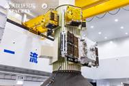
Figure 1 Photo of 6 satellites launched deployed on 1 rocket
integration
|
resource
monitoring, disaster emergency response, urban infrastructure management,
agricultural and forestry assessment, marine environment observation, and
geoscience research.
Additionally,
the ??Shenqi-02?? Satellite is the third satellite developed by Spacety with
operational InSAR imaging capability, supporting millimeter-level deformation
monitoring of the earth??s surface, possessing extremely wide application values
in key livelihood-related fields such as safety monitoring of water
conservancy, electricity, and transportation infrastructure, building safety
monitoring, and geological disaster emergency management[16?C20]. the
??Shenqi-02?? Satellite will provide global users with normalized, high-quality,
and self-controllable commercial InSAR image data services.
The ??Shenqi-02??
Satellite inherits the mature technology of Spacety??s in-orbit SAR satellites.
Through continuous optimization and iteration of the satellite platform and
payload, the overall performance and reliability of the satellite have been
continuously improved. The satellite platform of the ??Shenqi-02?? Satellite
incorporates 3 optimized designs: First, a new generation of electronics
architecture from Spacety was introduced for the first time, effectively
enhancing the reliability of the satellite service system and energy system,
and significantly improving the business support capability of the satellite
platform to support longer payload operation; Second, the precision orbit
determination system was upgraded, doubling the satellite??s orbit determination
accuracy and thus significantly improving the positioning accuracy of InSAR
imagery; Third, the data transmission system and attitude/orbit control system
were upgraded, significantly enhancing the satellite??s data downlink capability
and attitude maneuverability. In addition, the SAR payload was also optimized
in design to improve component phase stability and signal-to-noise ratio,
further enhancing the satellite??s imaging quality.
The main
specifications of the ??Shenqi-02?? Satellite are shown in Table 4. Meanwhile,
the table also shows that ??Shenqi-02?? is technically advanced and competitive:
its key parameters are not inferior to those of mainstream foreign commercial
satellites, and some parameters are even better.
Table 4
Key parameters
comparison between the ??Shenqi-02?? Satellite
and other commercial satellites
|
Indicators
|
Shenqi-02
|
ICEYE/Finland[21,22]
|
Capella/the United States[23]
|
|
Frequency band
|
C-Band
|
X-Band
|
X-Band
|
|
Antenna type
|
Phase Array
|
Phase Array
|
Parabolic
|
|
Antenna size
|
4.56 m??0.8 m
|
3.25 m??0.4 m
|
??3.5 m
|
|
Maximum
bandwidth (MHz)
|
300
|
300/600
|
700
|
|
Polarization
|
VV
|
VV
|
VV or HH
|
|
Incidence angle
|
15???C40??
|
15???C35??
|
15???C50??
|
|
Imaging mode
|
Spot/Sliding spot,
Strip, Scan
|
Spot/Sliding spot,
Strip, Scan
|
Spot/Sliding spot,
Strip
|
|
Resolution
and
swath width
|
Spot
|
1 m??0.5 m @ 7
km??
7 km
|
1 m??1 m @ 5 km??5
km
|
(0.4 m?C1.3
m)??0.5 m @ 5 km??5 km
(0.7 m?C2.3 m)??1
m @ 5 km??10 km
|
|
Strip
|
3 m @ 25 km
|
3 m @ 30 km
|
(1.1 m?C3.3 m)
??1.2 m @ 5 km??
20 km
|
|
Scan
|
20 m @ 170 km
|
15 m @ 100 km
|
/
|
|
Equivalent noise
figure/dB
|
Strip mode:
better than ?C22 dB
|
Strip mode:
better than ?C21.5 dB
|
Strip mode:
better than ?C22 dB
|
|
Orbit control
|
??150 m
|
??300 m
|
/
|
|
Post-processing precise
orbit determination accuracy
|
5 cm
|
/
|
/
|
|
Interferometry
capability
|
Provides
operational services
|
Be in the
experimental phase
|
No reports
available
|
|
Target rapid switching
capability
|
Rapid
electro-scan switching
|
Rapid electro-scan
switching
|
Attitude
adjustment switching
|
|
Data
transmission rate
|
900 Mbps
|
500 Mbps
|
1.2 Gbps
|
After the launch of
the ??Shenqi-02?? Satellite, all statuses were normal during its pass monitoring.
The next day, it executed the first imaging command and successfully acquired
the first batch of images, creating the fastest imaging record for Spacety??s
SAR satellites after orbit insertion (Figure 2).
After the
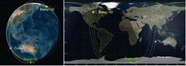
??Shenqi-02?? Satellite entered orbit, it will first carry out orbit adjustment
to enter the same repeat-pass interferometry pipeline as ??Shenqi-01?? and
??Fucheng-1?? (Figure 3). Thereafter, ??Shenqi-02?? will collaborate with
??Shenqi-01?? and ??Fucheng-1?? to carry out operational repeat-pass InSAR
services, and its interferometric measurement cycle will be shortened to 1 day.
|
|
|
|
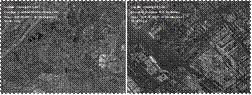
Figure 2 The first batch of images by Shenqi-02 (18-5-2025)
|
Figure 3 Satellite orbit and subsatellite
point simulation diagram of Shenqi-02, Shenqi-01 and Fucheng-1
|
3.3 The Dizhi-1 Satellite
The
??Dizhi-1?? Satellite is a hyperspectral geological remote sensing microsatellite[24]
led by China University of Geosciences, mainly used for geological environment
monitoring. The main parameters of ??Dizhi-1?? camera are shown in Table 5. The
??Dizhi-1?? Satellite has undergone concentrated and refined design of geological
exploration spectral bands, covering 410 nm to 2,480 nm, including 16 visible
light spectral bands and 10 short-wave infrared spectral bands, forming
characteristic spectral bands for geological industry applications. The
resolution and swath width of the visible spectrum of the ??Dizhi-1?? Satellite
are 14 m @ 43 km, and the resolution and swath width of the short-wave infrared
spectrum are 30 m @ 30 km.
|
Table 5 Main parameters of the Dizhi-1??s camera
|
|
Satellite
|
Dizhi-1
|
|
Imaging mode
|
Push-broom
|
|
Spectral range
|
410 nm?C2,480 nm
|
|
Quantity of spectral bands
|
Visible light band: 16
Short-wave infrared band:
10
|
|
Resolution
|
Visible light band: 14 m
Short-wave infrared band:
30 m
|
|
Swath width
|
Visible light band: 43 km
Short-wave infrared band:
30 km
|
|
Side swing angle supporting imaging
|
??20??
|
|
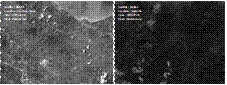
Figure 4 First batch of images by Dizhi-1 (20/22-5-2025)
|
In addition, the
??Dizhi-1?? Satellite has overcome several key technologies, including the design
of a highly reliable integrated opto-mechanical system, highly reliable
infrared focal plane filter spectroscopy technology, and camera TDI
multi-spectral visible light detection technology. These technological
breakthroughs have provided a solid foundation for the efficient application of
satellite data in the field of geological environment remote sensing. The
??Dizhi-1?? Satellite is capable of providing high-precision remote sensing data
and professional analysis services for the detection, monitoring,
identification, interpretation, and analysis of geological and environmental
features. Its application scope covers multiple fields, including mineral
composition detection, rock type identification, alteration information
extraction, soil quality assessment, and water pollution monitoring. Through
these high-quality data and services, the ??Dizhi-1?? Satellite has the
capability to provide high-precision remote sensing data and professional
analysis services for the geological and environmental fields, and is applied
to tasks such as detection, monitoring, identification, interpretation, and
analysis, its application scope covers multiple fields such as mineral composition
detection, rock type identification, alteration information extraction, soil
quality assessment, and water pollution monitoring. Through these high-quality
data and services, the ??Dizhi-1?? Satellite will assist scientists in more
accurately interpreting the geological structure of the Earth, providing strong
scientific basis and technical support for resource development, environmental
protection, and disaster prevention.
After the first week of testing, the ??Dizhi-1??
Satellite has preliminary achieved imaging capability and obtained the first
batch of images (Figure 4).
3.4 The NCHU-1 Satellite
|
Table 6 Main parameters of the NCHU-1??s camera
|
|
Satellite
|
NCHU-1
|
|
Imaging mode
|
Push-broom
|
|
Spectral range
|
Panchromatic band: 450?C850 nm
Multispectral band: 430?C860 nm
|
|
Quantity of spectral bands
|
Panchromatic band: 1
Multispectral band: 8
|
|
Resolution
|
Panchromatic band: 5 m
Multispectral band: 20
m
|
|
Swath width
|
100 km
|
|
Side swing
angle supporting imaging
|
??20??
|
The ??NCHU-1?? Satellite is a multispectral intelligent remote sensing
satellite for ecological environment monitoring, led by Nanchang Hangkong
University in its development. The satellite platform has significant
advantages in intelligence and autonomy. The carried multispectral camera
adopts an advanced off-axis three-mirror optical system, which comprehensively improves imaging performance and quality through fine optimization of optical parameters such as focal
length, field of view, F-number, clear aperture, spectral range, and band
selection. The main parameters of the ??NCHU-1?? Satellite multispectral camera
are shown in Table 6. The camera supports 1 panchromatic band (5 m resolution) and 8 multispectral bands (20 m resolution), with an imaging
swath width of 100 km.
Additionally, the
camera carries CMOS (Complementary Metal-Oxide-Semiconductor) detector
features high quantum efficiency, low noise performance, and high-speed imaging
capabilities, strongly supporting real-time monitoring and rapid response
applications. The ??NCHU-1?? Satellite excels in the field of water environment
remote sensing, capable of accurately detecting and analyzing water pollution,
water quality, and algae information. Meanwhile, it is also suitable for
terrestrial environment monitoring (such as
soil and vegetation), providing comprehensive data support for achieving
regional sustainable development goals.
|

Figure 5 First batch of images of the ??NCHU-1?? Satellite (30-5-2025)
|
Through the initial
week of testing, the ??NCHU-1?? Satellite has preliminary achieved imaging
capability and obtained the first batch of images (Figure 5).
3.5 The BUPT-2 and
BUPT-3 Satellites
The
??BUPT-2?? and ??BUPT-3?? satellites (the second batch of the TianSuan
Constellation) were developed by Beijing University of Posts and
Telecommunications, with the core mission of verifying cutting-edge
achievements in aerospace information technology. Both satellites are equipped
with laser communication payloads supporting a communication rate of 200 Gbps
and a communication distance of 2,000 km, and respectively carry space servers,
satellite-borne computers, and Kaufman electric propulsion systems. The
important in-orbit verification projects of the 2 satellites include 6G
intelligent semantic communication transmission, 6G satellite-borne core
network architecture testing, satellite-borne container operation reliability
and performance testing, satellite-ground high-speed data transmission link
protocol performance testing, satellite-ground IP network real-time audio-video
calling quality of service testing, on-board IoT time-series database
management system testing, and power consumption and heat dissipation-aware
satellite image inference. The collaborative application of these advanced
technologies will promote the gradual realization of the vision of ??both
space-side and ground-side data calculated in space??, contributing innovative
momentum and intelligent solutions for the country to explore the construction
of aerospace information infrastructure.
3.6 The SUSTech-1
Satellite
The
??SUSTech-1?? Satellite was the Southern University of Science and Technology??s
first space science micro-satellite, carrying the space electric field
measurement payload and aurora camera payload independently developed by the
university. The satellite also carries the GRID payload (Gamma Ray Integrated
Detection payload), the CXPD payload (Cosmic X-ray Polarization Detection
payload) from Guangxi University, as well as the satellite-ground IP link
terminal and thermoelectric conversion verification unit[25]
independently developed by Spacety. Among them, the space electric field
measurement payload, utilizing antenna booms, detects dynamic electric fields
in space plasmas, establishing itself as a critical technique for monitoring
Earth??s magnetosphere and ionosphere. This payload deployment marks the first
global instance of deploying an electric field antenna exceeding 10 m (up to 12
m) on a micro-satellite platform, breaking the record for micro-satellite
electric field antenna length. This breakthrough enables micro-satellites to
perform high-precision electric field measurements, offering new solutions for
the development of China??s deep space exploration technology.
The auroral camera
payload enables real-time monitoring of large-scale auroral phenomena, with a
focus on dynamically capturing auroral activities in high-latitude regions. As
China??s first micro-satellite-based auroral optical observation mission, the ??SUSTech-1??
Satellite leverages precision orbit design to provide a 9-minute continuous
observation window during each pass through the auroral zone. Its
high-sensitivity aurora imager meticulously documents morphological evolution
features of auroras, delivering critical observational data for decoding solar
wind-magnetosphere coupling mechanisms.
4 Special Features of Spacety??s
20th Space Mission
This
launch marks Spacety??s first dedicated six-satellite mission and its 20th space
expedition to date. With 37 satellites successfully deployed cumulatively, the
achievement not only signifies Spacety??s transformational shift
from ??single-satellite technology demonstration?? to ??volume
satellite production??, but also establishes the world??s first end-to-end C-band
commercial SAR satellite ecosystem??spanning satellite design, constellation
operations, and data services.
The successful
completion of this space mission demonstrates the following 2 characteristics.
(1) Practice of
Spacety??s full-range satellite products: It covers full-range satellite
products, including optical remote sensing satellites, SAR remote sensing
satellites, and scientific research satellites; it also covers full-range
satellite platforms, with applications of 20 kg to 300 kg-class satellite
platforms.
(2) In-orbit verification of multiple new technologies by Spacety:
??Shenqi-02?? will carry out key technology verification of in-orbit optical-SAR
collaboration with ??Dizhi-1?? and ??NCHU-1??, achieving efficient fusion
processing and precise utilization of the 2 types of remote sensing data,
improving the integrity, accuracy, and timeliness of earth observation data in
complex environments, and providing more reliable space-air-ground information
support for disaster emergency monitoring, environmental monitoring, resource
dynamic assessment and other fields. At the same time, relying on ??BUPT-2??,
??BUPT-3??, and ??SUSTech-1??, Spacety will focus on independently developing and
validating key technologies such as real-time data interaction via IP links
between satellites and ground stations, thermoelectric conversion, and attitude
control for laser inter-satellite communication. This move will comprehensively
enhance the technical capabilities of Spacety??s satellite platform in the
fields of intelligent measurement and control, efficient energy utilization,
and high-speed inter-satellite data transmission, laying a solid technical
foundation for the networking and operation of the next-generation
high-performance SAR satellites in the future.
5 Spacety??s SAR Constellation
and Satellite Technology Road Map
Spacety
aims to ??provide full-link technical support for the large-scale networking and
operation of commercial SAR remote sensing satellites, and build a highly
reliable and high-performance SAR constellation service system??,
comprehensively empowering space technology innovation and industrial
application ecosystem construction. Spacety??s SAR constellation plans to have
120 satellites, adopting a multi-inclination hybrid constellation scheme (Table
7). After the constellation is completed, the timeliness of earth observation
will be significantly improved: the maximum revisit period for global targets
is better than 30 minutes, the average revisit period for targets between 60??
north and south latitudes is better than 11 minutes, and the InSAR imaging coverage
period of the whole China does not exceed 2 days.
Table 7
Main parameters of
Spacety??s SAR constellation
|
No.
|
Inclination
|
Satellite quantity
|
Orbital planes quantity
|
Quantity of satellites per
orbital plane
|
Orbit altitude
|
|
1
|
97.4??
|
48
|
6
|
8
|
500 km
|
|
2
|
55??
|
48
|
6
|
8
|
500 km
|
|
3
|
35??
|
24
|
6
|
4
|
500 km
|
Facing the future
development trend of instant remote sensing SAR satellite constellations,
Spacety has bench-marked international cutting-edge technologies, established a
technical road map for lightweight small SAR satellites with high
spatial-temporal resolution, and launched the development of low-cost,
mass-produced, and high-performance SAR satellites for constellation deployment
(Figure 6). Focusing on technical directions such as commercial device-based,
miniaturized, lightweight, and standardized satellite technologies, Spacety
will prioritize breaking through more than 10 key technologies, including
satellite reliability design based on industrial-grade components, miniaturized
antenna array design, distributed energy system design, integrated
platform-payload structural design, and high-precision lightweight antenna deployment
mechanism design. It is committed to the research and development of core
components such as integrated modular integrated electronic systems and
lightweight modular digital phased array antennas. The technical level of
Spacety??s next-generation SAR satellites will be significantly improved with a
substantial cost reduction, making them suitable for mass and rapid
constellation deployment to support the upgrading of China??s commercial space
industry chain.
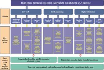
Figure 6 Technical roadmap for lightweight small SAR
satellites with high spatiotemporal resolution
6 Conclusion
The
successful 20th space mission of Spacety, launching six satellites by one
rocket, is not only a milestone in its commercial space endeavor but also marks
the leapfrog upgrade of China??s small satellite technology system from
??single-mission execution?? to ??systematic capability building??. The
differentiated payload configurations of the 6 satellites demonstrate Spacety??s parallel breakthrough
capabilities in multiple technical paths such as SAR remote sensing,
hyperspectral detection, and space environment monitoring??from operational
InSAR deformation monitoring by C-band SAR satellites, to precise inversion of
mineral compositions by hyperspectral satellites, and to in-orbit verification
of space electric field measurement and laser communication technologies. This
R&D model of ??platform-based universal design + payload modular
integration?? provides a replicable engineering paradigm for low-cost and
high-efficiency technological iteration in commercial space.
This successful
launch mission of Spacety is of milestone significance for industrial
development: it has achieved the first development upgrade from
??single-satellite verification?? to ??mass production??, and established a C-band
commercial SAR satellite industrial ecosystem covering the whole process of
??satellite design-constellation operation and maintenance-data service??. The 20-kg
to 300-kg full-spectrum satellite platform products launched this time not only
demonstrate Spacety??s comprehensive R&D strength and product matrix layout
in the field of small satellite technology, but also lay a solid foundation for
the subsequent industrial application of satellites.
Author Contributions
Zuo, Q. Y., Wen, Y. and Li,
Y. wrote the original draft; Du, J., Wang, L. Z., Tu, X. M., Wang, S. G., Liu,
K. J., Ren, W. J., Yang, F., Xiong, S. J., He, Y. X., Zheng, W. P., Liu, W. F.
and Li, G. S. reviewed and edited the paper.
Conflicts
of Interest
The
authors declare no conflicts of interest.
References
[1]
Department of Industry
and Information Technology of Hunan Province. Spacety: the satellite ??made
in Changsha?? soars in space [EB/OL]. (2024-10-21) [2025-5-17].
https://gxt.hunan.gov.cn/gxt/ztzl/zzgdzt/zzgdkqy/202410/
t20241021_33481125.html.
[2]
Baidu Baike. Radar satellite [OL].
https://baike.baidu.com/item/????????/2273221?from
Module=search-result lemma#4-7.
[3]
China News Service. Spacety completed its
20th space mission, having sent 37 satellites into space [EB/OL]. [2025-5-17].
https://www.chinanews.com.cn/sh/2025/05-17/10417172.shtml.
[4]
Baidu
Baike. Hisea-1 [OL].
https://baike,baidu.com/item/?????????fromModule=lemma search-box.
[5]
Baidu Baike. Chaohu-1 [OL].
https://baike.baidu.com/item/????????????/60179999?from
Module=search-result lemma.
[6]
Baidu Baike. Fucheng-1 [OL].
https://baike.baidu.com/item/?????????from
Module=lemma search-box.
[7]
Baidu Baike. SAR Satellite Shenqi [OL].
https://baike.baidu.com/item/??????????SAR????/65144824?fromModule=search-result lemma.
[8]
China Remote Sensing Application Association. Commercial
aerospace enterprises in China have achieved dual-satellite repeat-pass
interferometric imaging [EB/OL]. [2025-5-17].
http://www.carsa.org.cn/site/content/1187.html.
[9]
Baidu Baike. International Astronautical
Federation [OL]. https://baike.baidu.com/item/???????????????fromModule=lemma
search-box.
[10]
Baidu Baike. National Earth Observation
Science Data Center [OL].
https://baike.baidu.com/item/?????????????????????????fromModule=lemma
search-box.
[11]
Zuo, Q. Y., Wen, Y., Li, Y., et al.
Parameter dataset of six satellites of the Spacety??s 20th space mission by a
single rocket [J/DB/OL]. Digital Journal of Global Change Data Repository,
2025. https://doi.org/10.3974/geodb.2025.05.05.V1.
[12]
GCdataPR Editorial Office. GCdataPR data
sharing policy [OL]. https://doi.org/10.3974/dp.policy.2014.05 (Updated 2017).
[13]
Baidu Baike. Zhuque-2 Improved version Y2
launch vehicle [OL]. https://baike.baidu. com/item/???????????????????????????fromModule=lemma search-box.
[14]
Baidu Baike. Satellite Shenqi-02 [OL].
https://baike.baidu.com/item/??????02???from Module=lemma search-box.
[15]
Baidu Baike. Zhangye Constellation Space
Technology Co., Ltd. [OL]. https://baike.baidu.com/item/?????????????????????????fromModule=lemma search-box.
[16]
Wang, M. M., Wang, L. Y., Cai, J., et al.
Research progress of the application of InSAR technology in the deformation
monitoring of water conservancy project [J]. Jiangsu Water Resources,
2021(z2): 66?C71.
[17]
Zhang, Y. S. Research on key technologies of
time-series InSAR and its application in deformation monitoring of power
infrastructure [D]. Shaanxi: Xidian University, 2021.
[18]
Wang, X., Zheng, W. Q., Miao, X. L.
Monitoring the subsidence of traffic infrastructure in Xi??an City using InSAR
technology [C]. Proceedings of the 2020 Annual Conference of the Underground
Pipeline Professional Committee of China City Planning Association, 2020:
134?C138.
[19]
Zhu, M., Guo, T., Building safety risk
monitoring method based on InSAR [J]. Construction Science and Technology,
2024(9): 76?C79. DOI: 10.16116/j.cnki.jskj.2024.09.017.
[20]
Tao, C. X., Zhang, Y. S., Ren, S. S. Research
progress of InSAR technology application on landslide identification and
monitoring [J]. Geology in China, 2025, 52(2): 513?C526. DOI:
10.12029/gc20240515001.
[21]
Iceye. ICEYE Product Documentation [OL].
https://sar.iceye.com/latest/productspecification/ imagingmodes/.
[22]
360doc Personal Library. Analysis of
low-Earth orbit satellite TT&C technology (12): orbit control of ICEYE SAR
satellite [OL].
http://www.360doc.com/content/22/1217/18/65679503_1060613488.shtml.
[23]
Capellaspace. What SAR imagery products are
available with Capella? [OL].
https://support.capellaspace.com/what-sar-imagery-products-are-available-with-capella.
[24]
An, Z. H., Wang, L. Z. China??s first
hyperspectral remote sensing small satellite for the geological industry,
??Dizhi-1??, was successfully launched [EB/OL]. [2025-05-22].
https://www.iziran.net/news.html?aid=5394710.
[25]
Baidu Baike. Thermoelectric conversion [OL].
https://baike.baidu.com/item/?????????fromModule=lemma
search-box.