Boundary Data of Loess Plateau Region
Wang, Z. X.
Institute of Geographic Sciences and Natural Resources Research??Chinese Academy of Sciences, Beijing 100101, China
Keywords: Loess Plateau; boundary; data encyclopedia item
The Loess Plateau in mid-north China is well known because of geomorphology, loess deposition and as the ancient Chinese civilizations. However, there are different definitions about its extent. During 1955-1958, the First Water and Soil Conservation Expedition in min-stream Yellow River, organized by the Chinese Academy of Sciences (CAS), defined it as the areas extended from Mt. Taihang to Mt. Riyue (Mt. Sun & Moon) in east-west direction, and between Mt. Qinling and the Great Wall in south-north direction, which is basically a geomorphologic dimension.
|
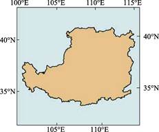
Figure 1 Geolocation of the Loess Plateau Region
|
Thirty years later, CAS launched a new integrated scientific surveying in Loess Plateau Region (LPR ) from 1984-1990, led by Professor Zhang, Youshi, deputy director of Commission for Integrated Survey of Natural Resources (CISNAR), Chinese Academy
of Sciences. Over 50 academic institutes, universities, and government agencies took part in this expedition, and more than 500 scientists made their contributions. Different from the 1955 expedition, the 1984 expedition was more application-oriented, influenced by the popular ‘territorial management’. As the result, 285 counties in 7 provinces or autonomous regions (including all area of the Shaanxi Province, Ningxia Hui Autonomous Region and part of the Shaanxi, Henan, Gansu, Qinghai Provinces and Inner Mongolia Autonomous Region) were selected in this expedition.
Geographically, the LPR extends from
Mt. Taihang in east to Mt. Riyue in west,
and from Mt. Qinling in south to Mt. Yinshan in north (114°33′42″E-100°52′00″E, 33°41′45″N
-41°16′43″N, Figure 1). The boundary data of Loess Pleateau Region is based on the 1??1 M county boundary dataset published by the Geoinformatic Center of China. The total area of LPR is 624,641 km2. The dataset was archived in .shp and .kmz data formats with the data size of 269 KB.