In Situ
Vegetation Dataset in Qinghai Lake Basin (2021?C2022)
Chen, Y. R.1,2,3 Sun, J. Q.4 Li, X. Y.1,2,3 Chen, K. l.1,2.,3*
1.
College of Geography, Qinghai Normal University, Xining 810008, China;
2.
Key Laboratory of Physical Geography and Environmental Process of Qinghai
Province, Qinghai Normal University, Xining 810008, China;
3.
Qinghai Lake Wetland
Ecosystem National Positioning Observation Station, Haibei 812200, China;
4. Qinghai Lake National Nature Reserve
Administration, Xining 810008, China
Abstract: Qinghai Lake basin is an important natural
geographical area in the northeast of the Qinghai-Tibet Plateau and a crucial
component of ecological security pattern in Qinghai province. In August 2021
and August 2022, the authors conducted vegetation survey on 29 sample sites in
the Basin. The dataset includes: (1) The geographical location and overview of
vegetation surveying sites; (2) The vegetation type structure of temperate
grassland, temperate desert grassland, alpine grassland, temperate desert,
mountain meadow and lowland meadow; (3) Statistics on the number of plant
families, genera and species; (4) Vegetation biomass statistics of Qinghai Lake
Nature Reserve and Przewalski??s gazelle activity area; (5) Annual vegetation
structure and biomass. The dataset is archived in .shp and .xlsx data formats,
and consists of 8 data files with data size of 124 KB (Compressed into one file
with 102 KB).
Keywords: Qinghai Lake basin; Qinghai-Tibet
Plateau; vegetation monitoring; 2021; 2022
DOI: https://doi.org/10.3974/geodp.2023.02.06
CSTR: https://cstr.escience.org.cn/CSTR:20146.14.2023.02.06
Dataset Availability Statement:
The
dataset supporting this paper was published and is accessible through the Digital
Journal of Global Change Data Repository at: https://doi.org/10.3974/geodb.2023.06.05.V1
or https://cstr.escience.org.cn/CSTR:20146.11.2023.06.05.V1.
1 Introduction
Biodiversity monitoring is a
vital task in biodiversity conservation in China. It is to quantitatively
monitor and study biological changes within a certain time and space range,
providing scientific basis for regional ecological protection[1].
Monitoring of vegetation diversity is the basis of the driving factor of the
loss of vegetation diversity and the intrinsic survival mechanism, as well as
the basis of the services of terrestrial ecosystems[2]. Vegetation
change in alpine regions has always been a hot issue in the field of climate
and ecology[3]. The research and monitoring of biodiversity in the
Qinghai Lake basin is the basic work of biodiversity conservation and research
in the Qinghai Lake basin. Grasslands are an important part of terrestrial
ecosystems, accounting for 40% of the world??s total land area and are the
crucial carbon reservoir in terrestrial vegetation[2]. As the hub of
soil, atmosphere and water, vegetation plays a vital role in biological
sustainability, climate regulation and maintaining the stability of terrestrial
ecosystems[4?C6]. Qinghai Lake basin is located in the northeast of
the Qinghai-Tibet Plateau, with a total area of about 29,600 km2 and
an altitude of 3,194?C5,174 m. It has diverse vegetation types, mainly meadow
and grassland[3]. Qinghai Lake is the largest inland saltwater lake
in China, and as a significant water body of the Qinghai-Tibet Plateau, it is
also an essential barrier to prevent desertification in western China and
maintain the ecological security of the northeast of the Qinghai-Tibet Plateau[7,
8].
This dataset was monitored from August 10 to 17, 2021
and August 1 to 11, 2022 with reference to the vegetation monitoring samples of
Qinghai Lake National Nature Reserve[9]. The vegetation monitoring
working group of Qinghai Lake National Nature Reserve carried out the
monitoring of localized vegetation. Finally, the vegetation ground measurement
dataset in Qinghai Lake basin (2021?C2022) was formed.
2 Metadata of the Dataset
Table 1 summarizes the
metadata of the In
situ vegetation dataset in Qinghai Lake basin (2021?C2022)[10].
It includes the dataset full name, short name, authors, year of the dataset,
dataset files, data publishing and sharing service platform, and data sharing
policy, etc.
3 Monitoring Methods
Vegetation
monitoring plots were deployed in the area around Qinghai Lake with 28 plots in
2021 and 29 plots in 2022, including the geographical location, vegetation
type, plant species, and plant biomass of the monitoring plots.
The sample plots
were set up in the monitoring plot, and one sample orientation was 1 m2
in the vegetation monitoring area of Qinghai Lake over the years, including 1
vegetation structure square, 10 vegetation frequency squares, a 25 m2
vegetation structure sample in shrub or tall herbs. The vegetation ground
biomass in the activity area of Przewalski??s gazelle was also determined, and
the biomass sample was 4.
The vegetation
cover and biomass of scrub or tall herb sample plots were calculated as
follows:
Vegetation cover of
sample plot = Herbaceous sample cover ?? (1-total cover of various shrubs or tall herbs) + total cover of
various shrubs or tall herbs. Where, total shrub or tall herb cover = ??(standard bush length ?? standard
bush width ?? ?? ?? 4 ?? standard bush number) ?? sample area.
Total biomass of
vegetation in the sample site = total biomass of various shrubs or tall herbs ??
area of shrub or tall herb sample + average biomass of herb sample ?? (1-total cover of various shrubs or tall herbs).
4 Data Results
4.1 Dataset Composition
(1)
Geographical location and overview of vegetation surveying sites; (2)
vegetation type structure of temperate grassland, temperate desert grassland,
alpine grassland, temperate desert, mountain meadow and lowland meadow; (3)
statistics on the number of plant families, genera and species; (4) vegetation
biomass statistics of Qinghai Lake Nature Reserve and Przewalski??s gazelle
activity area; (5) annual vegetation structure and biomass. The dataset is
archived in .shp and .xlsx data formats, and consists of 8 data files with data
size of 124 KB (Compressed into one file with 102 KB).
Table 1 Metadata summary of the In situ vegetation monitoring dataset of Qinghai
Lake basin (2021?C2022)
|
Items
|
Description
|
|
Dataset full name
|
In situ vegetation monitoring dataset of Qinghai Lake basin (2021?C2022)
|
|
Dataset short name
|
VegetationQinghaiLakeBasin2021-22
|
|
Authors
|
Chen, Y. R., Qinghai Normal University, 2776246502@qq.com
|
|
|
Sun, J. Q., Qinghai Lake National Nature Reserve Administration,
sunjq@163.com
|
|
|
Li, X. Y., Qinghai Normal University, lixingyue0102@163.com
|
|
|
Chen, K. L., Qinghai Normal University, ckl7813@163.com
|
|
Geographical region
|
Qinghai Lake basin
|
|
Year
|
2021, 2022
|
|
Data format
|
.shp, .xlsx
|
|
Data size
|
124 KB
|
|
Data files
|
8 data files (compressed to 1 files)
|
|
Foundations
|
Science and Technology Department of Qinghai Province (2022-QY-204);
Ministry of Science and Technology of P. R. China (2019QZKK0405)
|
|
Data publisher
|
Global Change Research Data Publishing & Repository,
http://www.geodoi.ac.cn
|
|
Address
|
No.
11A, Datun Road, Chaoyang District, Beijing 100101, China
|
|
|
Data
sharing policy
|
Data from the Global Change Research Data
Publishing & Repository includes metadata, datasets (in the Digital Journal of Global
Change Data Repository), and publications (in the Journal of Global
Change Data & Discovery).
Data sharing
policy includes: (1) Data are openly available and can
be free downloaded via the Internet; (2) End users are encouraged to use Data
subject to citation; (3) Users, who are by definition also value-added
service providers, are welcome to redistribute Data subject to written
permission from the GCdataPR Editorial Office and the issuance of a Data
redistribution license; and (4) If Data are used to compile new
datasets, the ??ten per cent principal?? should be followed such that Data
records utilized should not surpass 10% of the new dataset contents, while
sources should be clearly noted in suitable places in the new dataset[10]
|
|
|
Communication and searchable system
|
DOI,
CSTR, Crossref, DCI, CSCD, CNKI, SciEngine, WDS/ISC, GEOSS
|
|
|
|
|
|
4.2 Data Results
The
grassland vegetation survey of Qinghai Lake National Nature Reserve was
completed from August 10 to 17, 2021, lasting 8 days, and from August 1 to
August 11, 2022, lasting 11 days, and basic data such as vegetation nutrient
height, reproductive height, plant cluster, cover, biomass and species number
were obtained.
In 2021, 7
grassland classes and 17 grassland types were investigated, with a total of 118
species in 90 genera in 39 families. The average height of vegetative branches
and reproductive branches was 6.85 cm and 14.3 cm. Among them, the average
height of vegetative branches of dominant species was 12.5 cm, and the average
height of reproductive branches was 27.9 cm. The total vegetation cover and
dominant species coverage were 54.4% and 16%, respectively. The average total
biomass was 2,210.15 kg/ha. The average edible forage biomass in the active
area of Przewalski??s gazelle was 2,228.6 kg/ha. The available biomass is 1,760
kg/ha. In the past 12 years, the aboveground biomass of the Stipa sareptana
var. and Krylovii temperate grassland showed a slight trend of
decrease, that is, the Haixin mountain-like land may be mainly disturbed by the
long-term lack of grazing activities, and there is more litters on the surface,
which reduces the promotion effect of light on grassland plant growth. The
temperate grassland of Achnatherum splendens, Stipa spp. showed a significant increase trend, while the aboveground biomass
of the Stipa spp. temperate
desert, the Agropyron cristatum
temperate grassland and the Stipa breviflora temperate desert also showed a significant increase trend. The
aboveground biomass of Stipa purpurea alpine grasslands and Elymus nutans mountain meadows increased slightly.
In 2022, 7
grassland classes, 17 grassland types, a total of 29 plots, 29 vegetation
plots, 290 vegetation frequency plots, 56 aboveground biomass samples, 7 shrubs
and tall herbaceous samples were investigated, and a total of 222 species of
vascular plants in 125 genera in 47 families were recorded. The average height
of vegetative branches of vegetation community was 9.97 cm, the average height
of reproductive branches was 16.8 cm, the number of plant clusters was 266
clusters/m2, and the total vegetation coverage was 53.82%, among
which the average height of vegetative branches was 29.13 cm, and that of reproductive
branches of vegetation-dominant plants was 14.13 cm. The number of plants was
99/m2, and the community coverage was 27.88%. The average
aboveground biomass of 14 plots was 1,917.27 kg/ha, and the average edible
forage biomass in the Przewalski??s gazelle activity area was 2,228.6 kg/ha, of
which the available biomass was 1,760 kg/ha. In 2022, affected by comprehensive
factors such as long-term drought and grazing intensity in the early part of
the growing season, except for No. 047 plots (temperate deserts raised by
fences), the community height, cover and number of plants in most plots were
lower than the average values from 2010 to 2021. The height and cover of the
temperate grassland of the Stipa
Sareptana var. Krylovii and the Carex stenophylloides decreased compared with the average of previous years, but the
biomass reached a historical peak. The vegetation height, vegetation cover and
biomass of the Achnatherum splendens, Stipa spp. and Agropyron
cristatum temperate grassland and the alpine
grassland of the Stipa purpurea decreased significantly. Compared with
the average value of the previous years, the height, cover and biomass of the
temperate desert vegetation such as Stipa spp. increased
except for a slight decrease in vegetation height. Aboveground biomass in
mountain meadow of Elymus nutans is at an all-time low, which may be
due to continued overgrazing, in addition to climatic factors.
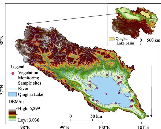
Figure 1 Map of monitoring sites for vegetation in
the Qinghai Lake basin
5 Summary
In
August 2021 and August 2022, vegetation monitoring was carried out in the
Qinghai Lake basin, and the monitoring of vegetation structure, plant
frequency, and habitat biomass of Przewalsk??s gazelle was completed for 7
grassland classes and 17 grassland types.
The
Qinghai-Tibet Plateau is the most unique geo-geographic-ecological unit on the
earth today, with unique biological resources, and occupies an irreplaceable
position in the map of world biodiversity[11]. Qinghai Lake basin is
a crucial natural geographical area of the Qinghai-Tibet Plateau[6],
and the monitoring of vegetation diversity in the Qinghai Lake basin aims to
clearly understand the status of vegetation resources in the basin, obtain the
temporal and spatial variation characteristics of vegetation resources, provide
scientific data support for the protection and rational utilization of
vegetation resources in the basin, provide a significant basis for the
construction of Qinghai Lake National Park and the Qinghai-Tibet Plateau
ecological civilization highland, and also provide data support for the
protection and restoration of the ecosystem of the Qinghai-Tibet Plateau[13].
Author Contributions
Chen, Y. R. and Chen, K.
L. designed the algorithms for the dataset. Sun, J. Q.,
Li, X. Y. and Chen, Y. R. contributed to data processing and analysis and Chen,
Y. R. wrote the paper.
Conflicts of Interest
The
authors declare no conflicts of interest.
References
[1]
Zhi, Y.
J., Yi, J. F., Liu, W., et al.
Monitoring of wintering waterbirds in the Nanji Wetland National Nature Reserve
of Poyang Lake [J]. Chinese Journal of
Ecology, 2020, 39(7): 2400?C2407.
[2]
Wu, H.,
Xu, X. H., Feng, X. J., et al.
Progress and prospects of biodiversity monitoring in China from a global
perspective [J]. Biodiversity, 2022, 30(10):
196?C210.
[3]
Sun, H.
Y., Li, B. Surface vegetation cover changes in China and their relationship
with climate factors [J]. Journal of
Remote Sensing, 1998, 2(3): 204?C210.
[4]
Li, X.
G., Zhu, L. Q., Chen, C. N. Analysis of spatial and temporal variation
characteristics of NDVI of vegetation in Henan province from 2000?C2015 [J]. Journal of Henan University (Natural Science Edition), 2018, 48(5): 554?C564.
[5]
Hou, Y., Chen, W. L., Zhong, C. Remote sensing monitoring
of spatial and temporal changes of vegetation cover in Inner Mongolia [J]. Journal of Northeast Forestry University,
2018, 46(11): 35?C40.
[6]
Gao, L.
M., Zhang, L. L. Study on the spatial and temporal variation of vegetation
cover in Qinghai Lake Watershed [J]. Journal
of Geoinformation Science, 2019, 21(9): 1318?C1329.
[7]
Gao, L.
M., Zhang, L. L., Chen, K. L. Microclimate characteristics analysis of wetlands
in Qinghai LakeWatershed [J]. Arid Zone
Research, 2019, 36(1): 186?C192.
[8]
Zhang,
L. L., Gao, L. M., Chen, K. L. Variation characteristics of radiation balance
and surface albedo in the Wayan Mountain wetland of the Qinghai Lake watershed
[J]. Journal of Glaciology and
Geocryology, 2018, 40(6): 1216?C1222.
[9]
Hou, Y.
S., He, Y. B., Xing, Z., et al.
Diversity and distribution of waterbirds in Qinghai Lake National Nature
Reserve [J]. Zoological Systematics,
2009, 34(1): 184?C187.
[10]
Cheng,
Y. R., Sun, J. Q., Li, X. Y., et al. In situ vegetation dataset in Qinghai
Lake basin (2021?C2022) [J/DB/OL]. Digital
Journal of Global Change Data Repository, 2023. https://doi.org/10. 3974/geodb.2023.06.05.V1.
https://cstr.escience.org.cn/CSTR:20146.11.2023.06.05.V1.
[11]
GCdataPR
Editorial Office. GCdataPR data sharing policy [OL].
https://doi.org/10.3974/dp.policy. 2014.05 (Updated 2017).
[12]
Deng,
T., Wu, F. X., Su, T., et al.
Qinghai-Tibet Plateau-an evolutionary hub for modern biodiversity formation [J].
China Science: Earth Science, 2020, 50(2): 177?C193.
[13]
Chen,
Z. R., Hou, Y. S., Chen, K. L., et al.
Vegetation monitoring dataset from 31 plots in Qinghai Lake watershed (2018)
[J]. Journal of Global Change Data
& Discovery, 2022, 6(1): 73?C77.
https://doi.org/10.3974/geodp.2022.01.10.
https://cstr.escience.org.cn/CSTR:20146.14.2022.01.10.