Video Presentation:
High-precision Oasis Dataset of China
Gui, D. W.1,2* Lin,
J. W.1 Liu, C.3
1.
Xinjiang Institute of Ecology and Geography, Chinese Academy of Sciences,
Urumqi 830011, China;
2. Xinjiang Technical Institute of Physics and
Chemistry, Chinese Academy of Sciences, Urumqi
830011, China;
3. Institute of Geographic Sciences and
Natural Resources Research, Chinese Academy of Sciences, Beijing 100101, China
Abstract: Oases play a critical
role in ecological balance, economic development, and biodiversity conservation
in arid regions. China, being the country with the largest distribution of
oases globally, is at the forefront of oasis studies. Establishing a high-precision
oasis dataset for China is of great significance for scientific research. The
??Video on oasis dataset of China?? utilizes a multimedia format, combining text,
images, and audio, to comprehensively explain the purpose, process, and
methodology of constructing this dataset. It highlights the three main
advantages of the dataset: high precision, comprehensive coverage, and strong
reliability. The spatial characteristics of oasis distribution are
demonstrated, revealing regional variations within China??s oases. Furthermore,
a management and query system for the oasis data has been established based on
the underlying logic of oasis coding, facilitating scientific research and
information retrieval related to oases.
Keywords: oasis; China; dataset;
spatial distribution; coding
DOI: https://doi.org/10.3974/geodp.2024.04.13
CSTR: https://cstr.escience.org.cn/CSTR:20146.14.2024.04.13
Dataset Availability Statement:
The
dataset supporting this paper was published and is accessible through the Digital Journal of
Global Change Data Repository at: https://doi.org/10.3974/geodb.2025.01.10.V1 or
https://cstr.escience.org.cn/CSTR:20146.11.2025.01.10.V1.
1 Introduction
Oases
are non-zonal geographic units formed on desert substrates in arid regions,
driven by stable water sources[1]. They stand in stark contrast to
the arid and barren environment due to their abundant water resources, fertile
soil, and lush vegetation[2]. Oases are crucial to agriculture,
livestock production, and the livelihood of people in arid regions[3].
In the northwestern arid regions of China, spanning nearly 3 million km2[4],
oases are widely distributed, either independently or in clusters, following
the availability of water. These areas exhibit a vast geographical span and
diverse types, occupying less than 10% of the region??s total area. Yet, they
support over 95% of the population in the arid zones and generate more than 90%
of the region??s social wealth[5]. As the core of the human- environment
system in arid regions[6], oasis science has been a focal point of
research for scholars in arid zone studies since the 1980s. Different
researchers, based on various objectives and perspectives, have proposed
different definitions of oases.
Overall, an
oasis must include the following three characteristics[7]: (1) it
exists in arid and semi-arid regions; (2) it is surrounded or partially
surrounded by desert environments; (3) it has a stable water supply, forming a
heterogeneous landscape unit with certain vegetation coverage or economic
productivity. Due to the relatively late establishment of a clear oasis
definition, although numerous studies on oases exist[8?C10], a
detailed inventory of oasis distribution in China has yet to be clarified. For
instance, the number of oases in China??s arid regions, the specific locations
and boundaries of each oasis, their topography and geomorphology, and the
sources of water that drive them, remain unclear, hindering the in-depth
development of oasis science. To address this gap, a team from the Xinjiang
Institute of Ecology and Geography and the Institute of Geographic Sciences and
Natural Resources Research, Chinese Academy of Sciences, spent four years
utilizing manual visual interpretation methods to compile the High-precision oasis
dataset of China. This dataset includes 42 data collections[11?C52],
all of which have been published in the Digital Journal of Global Change
Data Repository and are freely available for download. The ??Video on Oasis Dataset
of China??[53] serves as a detailed description of this dataset,
clearly outlining its three main advantages. First, high precision; the dataset
was created using the highest accuracy method, manual visual interpretation of
high-resolution remote sensing imagery; Second, comprehensive coverage; the
dataset covers all oases in China larger than 0.01 km2; Third,
strong reliability. the dataset has been verified through field investigations,
yielding a Cohen??s Kappa coefficient of 0.87, an AUC-ROC (Area Under the Receiver
Operating Characteristic Curve) of 0.935, and a 96.27% accuracy rate confirmed
through a random hexagonal grid method.
The video
provides a detailed demonstration of the construction process of the High- precision oasis dataset of China. Initially,
preparatory work was carried out. First, the definition of the oasis was
clarified, which is essential for distinguishing it from the surrounding desert
background and serves as the basis for extracting oasis boundaries.
Second, establish selection criteria for remote sensing imagery, with
cloud-free summer images being optimal. Third, the transition zone between
oases and deserts was identified, and the attribution of disputed areas was
clarified to minimize misclassification of types. Fourth, conduct professional
training for oasis extraction personnel to ensure accurate identification of
oasis boundaries.
Subsequently,
the oasis boundary extraction procedure was formally initiated. The delineation
process utilized high-resolution remote sensing imagery (<1 m spatial
resolution) from Google Earth Pro, with topographic data and vegetation
coverage indices as references. Visual interpretation methods were employed to
establish control points based on ground truth data using the platform??s
drawing tools. Subsequently, the extracted oasis boundary data were imported
into the geographic information system (GIS), with .kmz format data converted
to .shp format, line features transformed into polygons to construct the
preliminary high-precision oasis dataset of China. Finally, fundamental
geographic information??including climatic, geomorphological, and hydrological
data??was incorporated.
The video provides a comprehensive summary of the
spatial distribution characteristics of oases in China, offering a detailed
explanation of the distribution differences. This study comprehensively
presents the baseline distribution of oases across China in 2020.
(1) Overview:
There are 1,466 oases in China, covering a total area of 277,375.56 km2.
The easternmost point of China??s oases is located at the Houtao Plain
(109.97??E), the westernmost reaches the Kashgar region (74.13??E), the
northernmost extends to the Altai region (48.18??N), and the southernmost is in
the Qaidam Basin (35.96??N) (Figure 1).
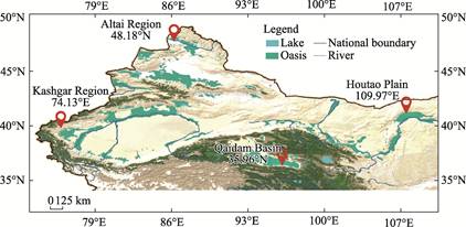
Figure 1 Distribution map of oases
in China
(2) Regional classification:
the oases of China are divided into 7 major regions, which are the Northern
Xinjiang Oasis Region, Southern Xinjiang Oasis Region, Qaidam Basin Oasis
Region, Hexi Corridor Oasis Region, Hetao Plain Oasis Region, and Alashan Oasis
Region. The Northern Xinjiang Oasis Region includes oases such as the Irtysh
River Oasis, Ili Oasis, and Hami Oasis; the Southern Xinjiang Oasis Region
includes oases such as the Aksu Oasis, Kashgar Oasis, and Ruoqiang Oasis; the
Qaidam Basin Oasis Region contains only the Qaidam Basin Oasis; the Hexi
Corridor Oasis Region includes oases such as the Yangguan Oasis, Shule River
Oasis, Heihe Oasis, and Shiyang River Oasis; the Hetao Plain Oasis Region
includes oases such as the Ningwei Plain Oasis, Yinchuan Plain Oasis, and
Houtao Plain Oasis; the Alashan Oasis Region includes oases such as the Alashan
Left and Right Banner Oasis and Ejin Oasis.
From the
administrative perspective, China??s oases are distributed across 5 provinces
and autonomous regions in the Northwestern Arid Region: Xinjiang, Gansu,
Qinghai, Ningxia, and Inner Mongolia (Figure 2). Among these, Xinjiang has the
largest area and the most oases, with an oasis area of 171,801.06 km2,
accounting for about 60% of the total oasis area in China, and 1,078 oases. The
second-largest oasis area is in Qinghai Province, covering 30,047.08 km2
with fewer oases, totaling 25. Gansu Province follows with an oasis area of
29,024.79 km2 and 316 oases, most of which are located in the
northern part of the Qilian Mountains, an important passage of the ancient Silk
Road. Inner Mongolia comes next with an oasis area of 25,201.61 km2
and 37 oases. The smallest oasis area is in Ningxia, with 13,301.02 km2
and only 10 oases.
It is
particularly worth noting that the video also presents the scientific
achievements of the oasis cataloging in China. Cataloging geographic units is
fundamental to geographical work. Compared to previously cataloged geographical
units such as lakes, wetlands, and glaciers??especially glaciers, which have
undergone two rounds of cataloging??oasis cataloging is still in its early
stages. Establishing a baseline for oases is essential to the cataloging
process.
Building on the oasis dataset, the video
introduces the underlying logic of oasis coding in China. 5 key attributes that
best represent oases??administrative regions, climate zones, landforms, rivers,
and area??were selected (Figure 3) for tiered coding. This approach led to
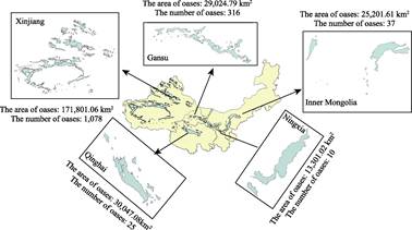
Figure 2 Map of number and area of oases
in each province (autonomous region)
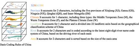
Figure 3 Oasis coding rules of
China
the
successful coding of 1,466 oases in China, assigning each oasis a unique
??academic identifier??. Establishing this oasis coding system allows for the
integration and comparison of oasis data, provides effective methods for
precise search, monitoring, and management of oases, and promotes the
quantitative and systematic advancement of oasis research in China. This
represents a pioneering contribution to the field of oasis science.
The ??Video on oasis
dataset of China?? has a duration of 4 minutes and 45 seconds, with the MP4
format and a size of 672 MB. It is available in both Chinese and English
versions. This is the first panoramic video to academically present and
publicly publish information about China??s oases. The video is of significant
reference value to scholars engaged in research related to natural geography,
economic geography, and ecology in arid regions. It has also become a trusted
source of knowledge for the general public to better understand the oases of
China.
Author Contributions
Liu, C. and Gui,
D. W. were responsible for the overall design of the dataset; Lin, J. W.
collected, processed, and validated the data; Gui, D. W. and Lin, J. W. wrote
the data-related papers.
Conflicts of Interest
The
authors declare no conflicts of interest.
References
[1]
Gao, H. J.
Distribution and types of oases in China [J]. Arid Land Geography,
1987(4): 23?C29.
[2]
Shen, Y.
C., Wang, J. W., Wu, G. H. Oases in China and their sustainable development
[J]. Arid Zone Resources and Environment, 2002(1): 1?C8.
[3]
Lin, J. W.,
Gui, D. W., Zhang, S. Y., et al. Dataset development of the Hotan Oasis,
water system,watershed, and elevation [J]. Journal
of Global Change Data & Discovery, 2023, 7(3): 314?C320. https://doi.org/10.3974/geodp.2023.03.10.
https://cstr.escience.org.cn/CSTR:20146.14.2023.03.10.
[4]
Xu, L. G.,
Zhou, H. F., Du, L., et al. Temporal and spatial changes in
precipitation in northwest China??s arid region from 1951 to 2008 and their
trends [J]. Chinese Journal of Desert Research, 2015, 35(3): 724?C734.
[5]
Chen, P.,
Wang, S., Liu, Y. X., et al. Spatio-temporal patterns of oasis dynamics
in China??s drylands between 1987 and 2017 [J]. Environmental Research
Letters, 2022, 17(6): 064044.
[6]
Chen, X.,
Luo, G. P. Ecological research and progress on oases in arid regions [J]. Arid
Land Geography, 2008(4): 487?C495.
[7]
Lin, J. W.,
Gui, D. W., Liu, Y. F., et al. A high-precision oasis dataset for China
from remote sensing images [J]. Scientific Data, 2024, 11: 726.
[8]
Han, D. L.
Artificial oases in Xinjiang [M]. Beijing: China Environmental Science Press,
2001.
[9]
Yang, F.
X., Fu, Q., Mu, G. J., et al. Discussion on oasis zoning in China [J]. Arid
Zone Research, 2007(5): 569?C573.
[10]
Liu, X. Y.,
Wang, Y., Xin, L. China??s oases have expanded by nearly 40% over the past 20
years [J]. Land Degradation & Development, 2022, 33(18): 3817?C3828.
[11]
Gui, D. W.,
Xue, J., Liu, Y., et al. Hotan Oasis [J/DB/OL]. Digital Journal of
Global Change Data Repository, 2020.
https://doi.org/10.3974/geodb.2020.09.13.V1.
[12]
Gui, D. W.,
Xue, J., Liu, Y., et al. Cele Oasis [J/DB/OL]. Digital Journal of
Global Change Data Repository, 2020.
https://doi.org/10.3974/geodb.2020.09.15.V1.
[13]
Gui, D. W.,
Xue, J., Liu, Y., et al. Daliyaboyi Oasis [J/DB/OL]. Digital Journal
of Global Change Data Repository, 2020.
https://doi.org/10.3974/geodb.2020.09.16.V1.
[14]
Gui, D. W.,
Xue, J., Liu, Y., et al. Gulahama Oasis [J/DB/OL]. Digital Journal of
Global Change Data Repository, 2020.
https://doi.org/10.3974/geodb.2020.09.17.V1.
[15]
Gui, D. W.,
Xue, J., Liu, Y., et al. Minfeng Oasis [J/DB/OL]. Digital Journal of
Global Change Data Repository, 2020.
https://doi.org/10.3974/geodb.2020.09.18.V1.
[16]
Gui, D. W.,
Wang, G. Y., Li, B. F., et al. Kashgar Oasis [J/DB/OL]. Digital
Journal of Global Change Data Repository, 2021.
https://doi.org/10.3974/geodb.2021.09.02.V1.
[17]
Gui, D. W.,
Li, B. F., Zhang, S. Y., et al. Aksu Oasis [J/DB/OL]. Digital Journal
of Global Change Data Repository, 2021.
https://doi.org/10.3974/geodb.2021.09.07.V1.
[18]
Gui, D. W.,
Li, B. F., Zhang, S. Y., et al. Boster Oasis [J/DB/OL]. Digital
Journal of Global Change Data Repository, 2021.
https://doi.org/10.3974/geodb.2021.09.08.V1.
[19]
Gui, D. W.,
Li, B. F., Zhang, S. Y., et al. Yarkant Oasis [J/DB/OL]. Digital
Journal of Global Change Data Repository, 2021.
https://doi.org/10.3974/geodb.2021.09.10.V1.
[20]
Gui, D. W.,
Li, B. F., Zhang, S. Y., et al. Qiemo Oasis [J/DB/OL]. Digital
Journal of Global Change Data Repository, 2021.
https://doi.org/10.3974/geodb.2021.11.04.V1.
[21]
Gui, D. W.,
Li, B. F., Zhang, S. Y., et al. Kongque River Oasis [J/DB/OL]. Digital
Journal of Global Change Data Repository, 2021.
https://doi.org/10.3974/geodb.2021.11.05.V1.
[22]
Gui, D. W.,
Li, B. F., Zhang, S. Y., et al. Ruoqiang Oasis [J/DB/OL]. Digital
Journal of Global Change Data Repository, 2021.
https://doi.org/10.3974/geodb.2021.11.08.V1.
[23]
Gui, D. W.,
Li, B. F., Zhang, S. Y., et al. Dinar River Oasis [J/DB/OL]. Digital
Journal of Global Change Data Repository, 2022.
https://doi.org/10.3974/geodb.2022.01.02.V1.
[24]
Gui, D. W., Li, B. F., Zhang,
S. Y., et al. Dataset of Hami Oasis outline, river and elevation cla-ssification
systems [J/DB/OL]. Digital Journal of Global Change Data Repository,
2022. https://doi.org/10.3974/geodb.2022.04.04.V1.
[25]
Gui, D. W.,
Zhang, S. Y., Li, B. F., et al. Yili Oasis, water system and elevation
classification dataset [J/DB/OL]. Digital Journal of Global Change Data
Repository, 2022. https://doi.org/10.3974/geodb. 2022.05.06.V1.
[26]
Gui, D. W.,
Li, B. F., Zhang, S. Y., et al. Dataset of oasis, river system,
mountainous part and elevation classification in the Keriya River catchment
[J/DB/OL]. Digital Journal of Global Change Data Repository, 2022.
https://doi.org/10.3974/geodb.2022.12.07.V1.
[27]
Gui, D. W.,
Li, B. F., Zhang, S. Y., et al. Tarim River Main Stream Oasis [J/DB/OL].
Digital Journal of Global Change Data Repository, 2022.
https://doi.org/10.3974/geodb.2022.12.08.V1.
[28]
Gui, D. W.,
Li, B. F., Zhang, S. Y., et al. Dataset of Turpan Oasis, river system,
mountainous part of the catchment and elevation classification [J/DB/OL]. Digital
Journal of Global Change Data Repository, 2023.
https://doi.org/10.3974/geodb.2023.01.03.V1.
[29]
Gui, D. W.,
Li, B. F., Zhang, S. Y., et al. Dataset of Weigan-Kuqa Oasis, river
system, mountainous part of the catchment and elevation classification
[J/DB/OL]. Digital Journal of Global Change Data Repository, 2023.
https://doi.org/10.3974/geodb.2023.01.06.V1.
[30]
Gui, D. W.,
Li, B. F., Zhang, S. Y., et al. Dataset of oasis, river system and
mountainous elevation classification in Ebinur Lake Basin [J/DB/OL]. Digital
Journal of Global Change Data Repository, 2023.
https://doi.org/10.3974/geodb.2023.01.08.V1.
[31]
Gui, D. W.,
Li, B. F., Zhang, S. Y., et al. Dataset of oasis, river system and
elevation classification in Barkol Lake Basin [J/DB/OL]. Digital Journal of
Global Change Data Repository, 2023. https://doi.org/10.3974/ geodb.2023.02.08.V1.
[32]
Gui, D. W.,
Li, B. F., Zhang, S. Y., et al. Dataset of Yiwu Oasis, river system,
catchment and elevation classification [J/DB/OL]. Digital Journal of Global
Change Data Repository, 2023. https://doi.org/10.3974/ geodb.2023.03.08.V1.
[33]
Gui, D. W.,
Li, B. F., Zhang, S. Y., et al. Dataset of Yangxia-Cedaya Oasis, rivers,
mountainous catchment and elevation classification [J/DB/OL]. Digital
Journal of Global Change Data Repository, 2023.
https://doi.org/10.3974/geodb.2023.04.08.V1.
[34]
Gui, D. W.,
Li, B. F., Zhang, S. Y., et al. Dataset of Pishan Oasis, rivers,
mountainous catchment and elevation classification [J/DB/OL]. Digital
Journal of Global Change Data Repository, 2023.
https://doi.org/10.3974/geodb.2023.04.09.V1.
[35]
Gui, D. W.,
Li, B. F., Zhang, S. Y., et al. Dataset of Oasis, water system, and
mountainous elevation classification in Alice Lake Basin [J/DB/OL]. Digital
Journal of Global Change Data Repository, 2023.
https://doi.org/10.3974/geodb.2023.06.08.V1.
[36]
Gui, D. W.,
Li, B. F., Zhang, S. Y., et al. Dataset of Irtysh River Oasis (China
part), water system and mountainous elevation classification [J/DB/OL].
Digital Journal of Global Change Data Repository, 2023.
https://doi.org/10.3974/geodb.2023.06.09.V1.
[37]
Gui, D. W.,
Li, B. F., Zhang, S. Y., et al. Dataset of Hebuke River Oasis, water
system and mountainous elevation classification [J/DB/OL]. Digital Journal
of Global Change Data Repository, 2023.
https://doi.org/10.3974/geodb.2023.06.10.V1.
[38]
Gui, D. W.,
Li, B. F., Zhang, S. Y., et al. Dataset of Oasis, water system and
elevation classification in the middle section of the northern slope of
Tianshan Mountains [J/DB/OL]. Digital Journal of Global Change Data
Repository, 2023. https://doi.org/10.3974/geodb.2023.07.04.V1.
[39]
Gui, D. W.,
Lin, J. W., Li, B. F., et al. Dataset of Emin River Oasis (China part),
water system and elevation classification [J/DB/OL]. Digital Journal of
Global Change Data Repository, 2023. https://doi.org/10.3974/ geodb.2023.07.05.V1.
[40]
Gui, D. W.,
Lin, J. W., Li, B. F., et al. Dataset of Yangguan Oasis, river system
and mountainous elevation classification [J/DB/OL]. Digital Journal of
Global Change Data Repository, 2023. https://doi.org/ 10.3974/geodb.2023.07.06.V1.
[41]
Gui, D. W.,
Lin, J. W., Li, B. F., et al. Dataset of Shiyang River Oasis, river
system, mountainous catchment and elevation classification [J/DB/OL]. Digital
Journal of Global Change Data Repository, 2023.
https://doi.org/10.3974/geodb.2023.07.07.V1.
[42]
Gui, D. W.,
Lin, J. W., Li, B. F., et al. Dataset of Heihe River Oasis, river
system, mountainous catchment and elevation classification [J/DB/OL]. Digital
Journal of Global Change Data Repository, 2023.
https://doi.org/10.3974/geodb.2023.08.05.V1.
[43]
Gui, D. W.,
Lin, J. W., Li, B. F., et al. Dataset of Shule River Oasis, river
system, mountainous catchment and elevation classification [J/DB/OL]. Digital
Journal of Global Change Data Repository, 2023.
https://doi.org/10.3974/geodb.2023.08.06.V1.
[44]
Gui, D. W.,
Lin, J. W., Wu, Y. H., et al. Dataset of Oasis, river system and
elevation classification in Tashkurgan River Basin [J/DB/OL]. Digital
Journal of Global Change Data Repository, 2023.
https://doi.org/10.3974/geodb.2023.09.06.V1.
[45]
Gui, D. W.,
Lin, J. W., Shi, R. X., et al. Tazhong Oasis [J/DB/OL]. Digital
Journal of Global Change Data Repository, 2023.
https://doi.org/10.3974/geodb.2023.09.07.V1.
[46]
Gui, D. W.,
Lin, J. W., Chen, X. N., et al. Alxa Left and Right Banner Oasis
[J/DB/OL]. Digital Journal of Global Change Data Repository, 2023.
https://doi.org/10.3974/geodb.2023.09.09.V1.
[47]
Gui, D. W.,
Lin, J. W., Wang, H. L., et al. Dataset of oasis, river system and
elevation classification in the Qaidam Basin catchment [J/DB/OL]. Digital
Journal of Global Change Data Repository, 2023.
https://doi.org/10.3974/geodb.2023.10.08.V1.
[48]
Gui, D. W.,
Lin, J. W., Shi, R. X., et al. Tarim desert road protection oasis dataset
[J/DB/OL]. Digital Journal of Global Change Data Repository, 2023.
https://doi.org/10.3974/geodb.2023.10.09.V1.
[49]
Gui, D. W.,
Lin, J. W., Zhang, H. Y., et al. Yinchuan Plain Oasis [J/DB/OL]. Digital
Journal of Global Change Data Repository, 2023.
https://doi.org/10.3974/geodb.2023.10.10.V1.
[50]
Gui, D. W.,
Lin, J. W., Zhang, X., et al. Ningwei Plain Oasis [J/DB/OL]. Digital
Journal of Global Change Data Repository, 2023.
https://doi.org/10.3974/geodb.2023.12.05.V1.
[51]
Gui, D. W.,
Lin, J. W., Yang, D., et al. Ejina Oasis [J/DB/OL]. Digital Journal
of Global Change Data Repository, 2023.
https://doi.org/10.3974/geodb.2023.12.06.V1.
[52]
Gui, D. W.,
Lin, J. W., Chun, X., et al. Houtao Plain Oasis [J/DB/OL]. Digital
Journal of Global Change Data Repository, 2024.
https://doi.org/10.3974/geodb.2024.01.10.V1.
[53]
Gui, D. W.,
Lin, J. W., Liu, C. Video on oasis dataset of China [J/DB/OL]. Digital
Journal of Global Change Data Repository, 2025.
https://doi.org/10.3974/geodb.2025.01.10.V1.