Monthly/8-km
Grid Meteorological Dataset at the Middle and Upper Reaches of the Yellow River
Basin of China (1980–2015)
Wang, Y. Q.1,2,3 Sun, L.1 Li, H. Y.1,3 Luo, Y.1,3*
1. Institute of Geographic Sciences and Natural Resources
Research, Chinese Academy of Sciences (CAS), Beijing 100101, China;
2. China Land Surveying and Planning Institute, Beijing
100035, China;
3. University of Chinese Academy of Sciences, Beijing
100049, China
Abstract: Climate conditions are important
factors for the China??s strategy toward the ecological protection and
high-quality development of the Yellow River. The monthly/8-km grid
meteorological dataset at the middle and upper reaches of the Yellow River
basin of China (1980–2015) was developed on the basis of the monthly average
temperature, maximum temperature, minimum temperature, average relative
humidity, average wind speed, precipitation (accumulated from 20:00 of the
previous day to 20:00 of the current day), sunshine hours, and potential
evapotranspiration calculated using the Penman–Monteith algorithm at 195
stations surrounding the middle and upper reaches of the Yellow River basin.
Using the platform of ANUSPLIN, this study constructed the smooth spline
functions of thin plates with different variables by comprehensively
considering the influence of topography on the spatial differentiation of air
temperature, wind speed, and humidity; and the effects of radiation, humidity,
and wind speed on potential evapotranspiration. The dataset includes the
following: (1) boundary data of the upper and middle
reaches of the Yellow River basin; and (2) monthly/8 km average
temperature, maximum temperature, minimum temperature, average relative
humidity, average wind speed, precipitation, sunshine hours, and potential
evapotranspiration data from 1980 to 2015. The dataset was archived in .shp and
.img data formats and consists of 3,463 data files with a size of 672 MB
(compressed to a single file with a size of 138 MB).
Keywords: Yellow River basin;
meteorological; climate change; spatial interpolation
DOI: https://doi.org/10.3974/geodp.2022.01.04
CSTR: https://cstr.escience.org.cn/CSTR:20146.14.2022.01.04
Dataset Availability Statement:
The dataset
supporting this paper was published and is accessible through the Digital Journal of Global
Change Data Repository at: https://doi.org/10.3974/geodb.2021.07.09.V1 or
https://cstr.escience.org.cn/CSTR:20146.11.2021.07.09.V1.
1 Introduction
The Yellow River basin across four geomorphic units (i.e.,
Qinghai–Tibet Plateau, Inner Mongolia Plateau, Loess Plateau, and North China
Plain) covers nine provinces from the west to east. It is an important
ecological barrier and economic belt in northern China, and it plays a vital
role in ecological security and high-quality economic and social development in
China. Most of the Yellow River basin is located in the arid and semi-arid
areas of China, which has a continental climate[1]. The issue of
water resources is severe and thus seriously restricts the ecological protection and high-quality development of the Yellow River
basin[2–4]. According to previous studies, climate change is one of
the main factors affecting hydrological processes, and it is closely related to
the spatial distribution, utilization patterns, and security of water resources
in the Yellow River basin[2]. To improve China??s forest
coverage, the national government implemented the compulsory tree-planting
campaign in 1980. Moreover, the pilot work of returning farmland to forest and
grassland was conducted in the middle and upper reaches of the Yellow River in
2000. After nearly 40 years of unremitting efforts, the vegetation condition in
the Yellow River basin has improved significantly[5]. However, the
ensuing issues of water resources have become aggravated and are characterized
by increased ecological water demand, increased evapotranspiration, decreased
runoff production, reduced water and increased sediments from different
sources, dry stratified soil, and shortage of water resources downstream[6–11].
Therefore, clarifying the climate conditions and taking efficient measures to
restore ecological protection and manage natural resources on the basis of
limited water resources are important in implementing and promoting the
national strategic goals proposed by Chairman Xi to achieve ecological
protection and high-quality development in the Yellow River basin. These
approaches are also important steps to achieve the spirit of ??The urban
development, land use, population size and production scale should be
determined based on local water resource.??.
Theoretically,
precise grid meteorological datasets should be gathered by high-density station
networks. However, economic, technical, and topographic issues result in
limited meteorological stations with an uneven spatial distribution and insufficient
density[12]. Generally, the observation data from meteorological
stations at fixed points cannot be directly used in other areas without
observation data. These engaged regions can only be estimated using the
observation data of adjacent meteorological stations and certain mathematical
algorithms (i.e., spatial interpolation of meteorological data)[13].
At present, the commonly used spatial interpolation approaches can be divided
into deterministic interpolation and geo-statistical interpolation[14].
Deterministic interpolation mainly includes polynomial interpolation, trend
surface analysis, and inverse distance weighting methods. Geo-statistical
interpolation methods include Kriging and Spline methods. The Kriging methods
are based on the known spatial distribution of meteorological stations and fit
surfaces through mathematical functions, while spline methods can fit surfaces
and quantify errors through statistical and mathematical methods[15].
For different meteorological factors and regions, each interpolation approach
has its own advantages and disadvantages. In recent years, interpolation
software called ANUSPLIN based on the spline function method has been widely
used because of its high interpolation accuracy[16–18]. ANUSPLIN is
professional meteorological data interpolation software developed by Australian
scientist Hutchinson on the basis of thin plate spline theory. The software
allows the introduction of multiple covariant quantum models to process 2D
splines into multidimensional ones and perform a spatial interpolation of
multiple surfaces; hence, it is suitable for the interpolation of time series
meteorological data[19]. Therefore, on the basis of the observation
data of the meteorological stations surrounding the Yellow River basin from
1980 to 2015, a monthly grid meteorological dataset with a resolution of 8 km
was obtained by interpolation in the current work. Moreover, climate change in
the Yellow River basin in the past 36 years was analyzed to provide a
scientific basis for the ecological protection and high-quality development of
the basin.
2 Metadata of the Dataset
The metadata of the Monthly/8-km grid meteorological
dataset at the middle and upper reaches of the Yellow River basin of China
(1980–2015)[20] is summaried in Table 1.
Table
1 The metadata summary
of the Monthly/8-km grid meteorological dataset at the middle and upper reaches
of the Yellow River basin of China (1980–2015)
|
Items
|
Description
|
|
Dataset full name
|
Monthly/8-km grid meteorological
dataset at the middle and upper reaches of the Yellow River basin of
China(1980-2015)
|
|
Dataset short name
|
MeteoDataYellowRB_1980-2015
|
|
Authors
|
Wang, Y. Q., Institute of
Geographic Sciences and Natural Resources Research, CAS, University of
Chinese Academy of Sciences, wangyq.14b@igsnrr.ac.cn
Sun,
L., Institute of
Geographic Sciences and Natural Resources Research, CAS; University of
Chinese Academy of Sciences, sunlin-cas@hotmail.com
Li,
H. Y., Institute of
Geographic Sciences and Natural Resources Research, CAS; University of Chinese
Academy of Sciences, lihy.15b@igsnrr.ac.cn
Luo,
Y., Institute of
Geographic Sciences and Natural Resources Research, CAS; University of
Chinese Academy of Sciences, luoyi@igsnrr.ac.cn
|
|
Geographical region
|
The Middle and upper reaches of
the Yellow River basin of China
|
|
Year
|
1980–2015
Data format .shp,
.img Data size 672 MB
|
|
Temporal resolution
|
Monthly
Spatial resolution 8 km??8 km
|
|
Units
|
Average temperature, maximum
temperature, minimum temperature:??C; average relative humidity: %; average
wind speed at 2 m: m/s; precipitation (accumulated from 20:00 of the previous
day to 20:00 of the day): mm; sunshine hours: h; potential
evapotranspiration: mm
|
|
Data files
|
(1) The boundary data of the upper
and middle reaches of the Yellow River basin; (2) the monthly/8-km average
temperature, maximum temperature, minimum temperature, average relative
humidity, average wind speed, precipitation, sunshine hours, and potential
evapotranspiration data from 1980 to 2015. The dataset is archived in .shp
and .img data formats, and consists of 3,463 data files. From January 1980 to
December 2015, each meteorological factor file is named in the form of YYYY
mm. img. For example, 198001 is ???? data in January 1980
|
|
Foundations
|
Ministry of Science and Technology
of P. R. China (2016YFC0501603); Chinese Academy of Sciences (XDA20060301)
|
|
Date Computing
environment
|
ANUSPLIN4.3
|
|
Data
publisher
|
Global Change Research Data Publishing &
Repository, http://www.geodoi.ac.cn
|
|
Address
|
No.
11A, Datun Road, Chaoyang District, Beijing 100101, China
|
|
Data
sharing policy
|
Data from
the Global Change Research Data Publishing & Repository includes metadata, datasets
(in the Digital Journal of Global Change Data Repository), and
publications (in the Journal of Global Change Data & Discovery). Data sharing policy
includes: (1) Data are openly available and can be free downloaded via the
Internet; (2) End users are encouraged to use Data subject to
citation; (3) Users, who are by definition also value-added service
providers, are welcome to redistribute Data subject to written permission
from the GCdataPR Editorial Office and the issuance of a Data redistribution
license; and (4) If Data are used to compile new
datasets, the ??ten per cent principal?? should be followed such that Data
records utilized should not surpass 10% of the new dataset contents, while
sources should be clearly noted in suitable places in the new dataset[14]
|
|
Communication and
searchable system
|
DOI, CSTR, Crossref, DCI,
CSCD, CNKI, SciEngine, WDS/ISC, GEOSS
|
3 Data Source and Methods
3.1 Data Source
The
meteorological station data used in this dataset are
the daily surface climatic data of
China shared by the China
Meteorological Data Service Center. The observation
data are mainly obtained from the basic and benchmark
meteorological stations and automatic stations in China. The monthly/8-km grid
meteorological dataset at the middle and upper reaches of the Yellow River
basin of China (1980–2015) was developed on the basis of the monthly average temperature,
maximum temperature, minimum temperature, average relative humidity, average
wind speed, precipitation (accumulated from 20:00 of the previous day to 20:00
of the current day), sunshine hours, and the potential evapotranspiration
calculated using the Penman–Monteith (P-M) algorithm at 195 stations
surrounding the middle and upper reaches of the Yellow River basin. The
boundary of the middle and upper reaches of the Yellow River basin was
extracted from the SRTM 90 m resolution digital elevation model built using the
hydrological modeling tool in the extension module toolbox of ARCGIS10.3
Spatial Analyst. The spatial range of the Yellow River basin was determined
according to the situation of the river, flow direction, and outlet.
Furthermore, the Huayuankou station was taken as the dividing line between the
middle and upper reaches of the Yellow River basin and the lower reaches.
3.2 Methods
3.2.1
Potential Evapotranspiration Calculation
The P-M algorithm
is widely applied to calculate potential evapotranspiration[22] as
it considers the physiological characteristics and aerodynamic parameters of
crops. This algorithm is suitable for calculating the land surface
evapotranspiration of vegetation covering landscapes. It comprises a radiation
term in radiation balance and an aerodynamic term based on temperature, wind
speed, and water pressure difference. Its expression is as follows:
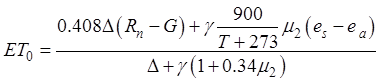 (1)
(1)
where ET0
is the potential evapotranspiration (mm); ?? is the slope of the curve between the
saturation vapor pressure and the air temperature (kPa/ºC); Rn is the net radiation
received at the surface (MJ/m2); G is the soil heat flux (MJ/m2);
es and ea, respectively, denote the
saturated vapor pressure and actual vapor pressure (kPa); g is the
dry and wet constant, (kP/ºC); m2 is the wind speed
at 2 m (m/s); and T is the average temperature (ºC). Rn is
a variable of the received solar radiation and is generally estimated using the
empirical formula based on sunshine hours, which can be expressed as
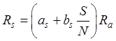 (2)
(2)
where as and
bs are linear empirical
parameters, which are the most widely estimated errors in solar radiation
calculation. For the monthly/8-km grid meteorological dataset in our study, the
observed pan evaporation data were used as the potential evapotranspiration
data computed by the P-M algorithm; thus, the empirical parameter values of as and bs were back stepped. The potential evapotranspiration
computed by the P-M algorithm is indeed water surface evaporation, which
represents the maximum evaporation capacity of the region. According to the
previous expressions, geographical factors (i.e., latitude and elevation) and
meteorological factors (i.e., wind speed, minimum temperature, maximum
temperature, sunshine duration, relative humidity, and pan evaporation) should
be used as inputs in the calculation of potential evapotranspiration.
3.2.2
Interpolation Method
The monthly/8-km grid meteorological dataset was
interpolated using the model in Table 2. Specifically, the minimum temperature,
maximum temperature, average temperature, wind speed,
relative humidity, and radiation were interpolated with longitude and latitude
as the independent variables and with elevation as the coverable. Meanwhile,
potential evapotranspiration was interpolated with longitude and latitude as
the independent variables and with radiation,
relative humidity, and wind speed as coverable. Sunshine duration was
interpolated with longitude and latitude as independent variables. As
precipitation is characterized by randomness, inhomogeneity, and large
numerical range, square root transformation was performed herein, with
longitude and latitude taken as independent variables.
Table 2
Spatial interpolation model of meteorological factors
|
Meteorological factor
|
Model
|
Independent variables
|
Covariable
|
Data
conversion
|
Number of spline
|
|
Maximum temperature
|
TVPTPS
|
Longitude and latitude
|
Elevation
|
|
2, 3
|
|
Minimum temperature
|
TVPTPS
|
Longitude and latitude
|
Elevation
|
|
2, 3
|
|
Average temperature
|
TVPTPS
|
Longitude and latitude
|
Elevation
|
|
2, 3
|
|
Wind speed
|
TVPTPS
|
Longitude and latitude
|
Elevation
|
|
2
|
|
Precipitation
|
BVTPS
|
Longitude and latitude
|
|
Square root transformation
|
2
|
|
Relative humidity
|
TVPTPS
|
Longitude and latitude
|
Elevation
|
|
2
|
|
Sunshine hours
|
BVTPS
|
Longitude and latitude
|
|
|
2, 3
|
|
Potential evapotranspiration
|
QVPTPS
|
Longitude and latitude
|
Radiation, relative
humidity, wind speed
|
|
2, 3, 4
|
Note: BVTPS, bivariate thin disk smooth spline
function; TVPTPS, three-variable local thin disk smooth spline
function; QVPTPS, variable local thin disk smooth spline function.
4 Data Results and Validation
4.1 Data Files
The monthly/8-km grid meteorological dataset at the middle
and upper reaches of the Yellow River basin of China (1980–2015) includes the
following:
(1)
Boundary data of the upper and middle reaches of the Yellow River basin;
(2)
Grid data of monthly maximum temperature;
(3)
Grid data of monthly minimum temperature;
(4)
Grid data of monthly average temperature;
(5)
Grid data of monthly average wind speed;
(6)
Grid data of monthly precipitation (accumulated from 20:00 of the previous day
to 20:00 of the current day);
(7)
Grid data of monthly average relative humidity;
(8)
Grid data of monthly sunshine hours;
(9)
Grid data of monthly potential evapotranspiration.
The
dataset is archived in .shp and .img data formats and consists of 3,463 data
files with a size of 672 MB (compressed to a single file with a size of 138 MB)
and monthly temporal and spatial resolutions of 8 km ?? 8 km. Files are stored
by meteorological factors and labeled in the following format: YYYYmm.img.
4.2 Data Results
4.2.1
Analysis of Climate Conditions across the Yellow River Basin
The
climatic conditions (i.e., 1980–2015) across the Yellow River basin have an apparent
spatial heterogeneity (Figure 1). For example, the spatial
distribution pattern of temperature is shown in Figs.1a, 1b, 1c,the annual
average temperature decreased from west to east with the elevation and showed
an increasing trend (Figure 1c) with a variation range of −11.7– 15.1 ºC. The annual
mean temperature was 5.8 ºC. Sunshine hours showed a decreasing trend from
southeast to northwest (Figure 1d), and the average annual sunshine hours were
2,562 h. The relative humidity decreased from 77.5% to 42.8% from south to
north, and the average value was 58%. The average wind speed in the northern
source region of the Yellow
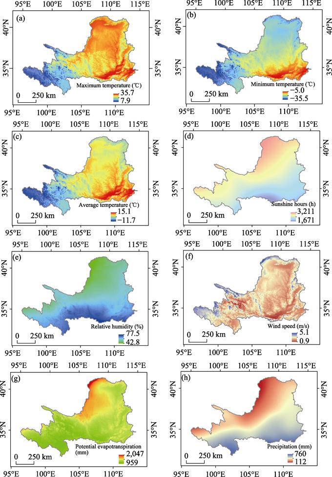
Figure 1 Spatial pattern of meteorological factors
across the Yellow River basin
River and the high-altitude region is
relatively large (Figure 1f), with a maximum value of 5 m/s and an annual average value of 2.5 m/s. The
annual average potential evapotranspiration in the middle reaches of the Yellow
River gradually increased from southeast to northwest (Figure 1g). The maximum
potential evapotranspiration in the arid region of the northwest of the Yellow
River was over 2,000 mm. The mean annual precipitation gradually decreased
from 760 mm in the southeast to 112 mm in the northwest (Figure 1h). Generally,
the climate conditions of the Yellow River can be depicted as follows:
(1) low temperature, high sunshine hours, high wind speed,
and low potential evapotranspiration for the source region;
(2) low precipitation and humidity for the northern region;
(3) high precipitation and humidity for the southern
region.
Meanwhile, the climate
conditions of the middle reach of the Yellow River basin can be depicted as
follows:
(1) high humidity and temperature, short sunshine duration,
low wind speed, large precipitation, and small potential
evapotranspiration for the southeastern region;
(2) dry climate characterized by low temperature in winter
and high temperature in summer, long sunshine duration, high wind speed, small
precipitation, and large potential evapotranspiration for the northwestern
region.
4.2.2
Temporal Climate Variations in the Yellow River Basin
(1) Seasonal variation
The
climate conditions in the Yellow River basin show obvious seasonal variations.
With regard to temperature, it increases in spring, reaches a maximum of
18.6 ºC in July in summer, gradually decreases in autumn, and
drops to −8.7 ºC in winter. For relative humidity, it is the
lowest in April at 48.2%, it reaches the maximum value of 69.9% in August, and
remains stable in winter in the range of 51.6%–53.4%. For the sunshine
duration, it increases gradually in spring, reaches a maximum of 3,332 h in
August, and fluctuates slightly in winter. For wind speed, the maximum occurs
in April at 3 m/s. For precipitation, the average value in summer (July) is
87.5 mm, and the total precipitation in winter is only 10.3 mm. Meanwhile, the
potential evapotranspiration from April to June is relatively large at 504.8
mm, which in May is the maximum at 180.6 mm and in winter at 129.1 mm.
Generally, the seasonal characteristics of the climate conditions in the Yellow
River basin can be depicted as follows: 1) In spring, sunshine duration,
temperature, and wind speed increase; precipitation slightly increases;
relative humidity slightly decreases; and potential evapotranspiration thus increases
and reaches the maximum annual value. 2) In summer, precipitation increases
significantly, sunshine duration demonstrates a fluctuation obviously
characterized as decreasing slightly at first and then increasing, temperature
increases significantly, wind speed gradually decreases, relative humidity
increases, and potential evapotranspiration thus gradually decreases. 3) In
autumn, with the decrease of sunshine duration, temperature, precipitation,
wind speed, relative humidity, and potential evapotranspiration also decrease.
4) In winter, with the slight fluctuations in sunshine duration, precipitation,
wind speed, and relative humidity, the temperature continues to decline, and
potential evapotranspiration gradually decreases to the minimum value.
(2) Inter-annual variability
From 1980 to 2015, the
inter-annual variation of the meteorological factors in the Yellow River basin
showed great spatial and temporal heterogeneity. For the mean values, the
temperature showed a significant upward trend, and the inter-annual change rate
(i.e., linear regression coefficient) was
0.5 ºC/10a. The relative humidity and wind
speed showed a significant decreasing trend, and the inter-annual change rates
were −0.7%/10a and −0.1 m/(s·10a),
respectively. Sunshine duration, precipitation, and potential
evapotranspiration showed no obvious inter-annual variation
trend. According to the spatial distribution pattern of the annual
variation of the meteorological factors, the temperature increase in the source
region of the Yellow River was significantly greater than that in the middle
reaches of the Yellow River. The mean warming amplitudes of the maximum
temperature, minimum temperature, and average temperature were very close (0.5 ºC/10a), but
their spatial distribution patterns were different (Figure 4a, 4b, and 4c,
respectively). The sunshine duration in the southern region showed an
increasing trend while that in the eastern region showed a decreasing trend
(Figure 4d). The relative humidity of the source region, southeastern
region, and northern region of the Yellow River showed a decreasing trend while
that from the Qilian Mountains to the Qinling Mountains, the inner flow region
of Ordos, northern Shaanxi, and central and southern Ningxia showed an
increasing trend (Figure 4e). The mean wind speed of the source region of
the Yellow River and the northwestern region of the middle reaches showed an
increasing trend, while the wind speed of the southeastern region showed a
decreasing trend (Figure 4f). Moreover, 30.7% of the
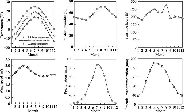
Figure 2 Seasonal variation
of meteorological factors across the Yellow River basin
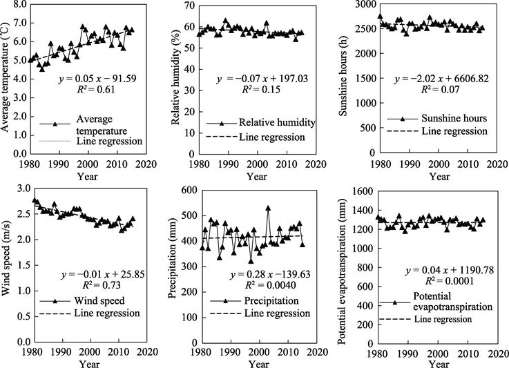
Figure 3 Inter-annual variation of meteorological
factors across the Yellow River basin
regions showed a decreasing trend, which was mainly
distributed in the southern part of the Yellow River basin and with the average
inter-annual change rate being −9.0 mm/10a; 69.3% of the regions showed an
increasing trend, which was mainly distributed in the northern part and with
the average inter-annual variation rate being 8.1 mm/10a (Figure
4h). About 51.2% of the potential evapotranspiration showed a decreasing
trend, which was mainly distributed in the source and northwestern regions of
the Yellow River and with the average inter-annual change rate being −18.3
mm/10a. In addition, 48.9% of the potential evapotranspiration showed an increasing
trend, which was mainly distributed in the central, southern, and eastern
regions of the Yellow River basin. The average inter-annual change rate
was 20.0 mm/10a (Figure 4g).
4.3 Data Validation
The standard errors of
prediction of the monthly/8-km grid meteorological dataset were
assessed. The standard errors of the minimum temperature, maximum
temperature, and average temperature were 1.18 –1.33 ºC, 0.86 –1.06 ºC, and 0.80 –0.95 ºC, respectively. The standard errors of the mean
wind speed, relative humidity, potential evapotranspiration, precipitation, and
sunshine hours were 0.69–0.83 m/s, 4.54–5.55 mm, 6.52–7.88 mm, 1.03–1.21 mm,
and 19.43–21.84 h, respectively (Table 3). With respect to the spatial
distribution, the regions with large standard errors of prediction are mainly
located in the northwest and in the regions with relatively few meteorological
stations at high altitudes. With respect to the temporal distribution, the
standard error of the mean monthly temperature prediction in summer is
significantly smaller than that in winter. The standard error of the mean
minimum temperature prediction is the largest. The standard error of the
monthly mean precipitation forecast in winter is smaller than that in summer
and is positively correlated with precipitation. The error of the
potential evapo-transpiration prediction from April to August is relatively
large.
Table 3
The standard errors of prediction of the
monthly/8-km grid meteorological dataset
|
Meteorological
factor
|
Item
|
Jan.
|
Feb.
|
Mar.
|
Apr.
|
May
|
Jun.
|
Jul.
|
Aug.
|
Sept
|
Oct.
|
Nov.
|
Dec.
|
Mean
|
|
Minimum
temperature
|
Min
|
1.72
|
1.45
|
1.17
|
1.08
|
1.03
|
0.97
|
0.86
|
0.87
|
0.94
|
1.10
|
1.35
|
1.62
|
1.18
|
|
Max
|
1.91
|
1.62
|
1.33
|
1.21
|
1.15
|
1.09
|
0.99
|
1.03
|
1.07
|
1.20
|
1.51
|
1.81
|
1.33
|
|
Mean
|
1.75
|
1.48
|
1.21
|
1.11
|
1.05
|
0.99
|
0.89
|
0.90
|
0.96
|
1.11
|
1.40
|
1.65
|
1.21
|
|
Maximum
temperature
|
Min
|
0.94
|
0.94
|
0.86
|
0.96
|
0.86
|
0.78
|
0.81
|
0.82
|
0.79
|
0.81
|
0.85
|
0.92
|
0.86
|
|
Max
|
1.15
|
1.17
|
1.10
|
1.16
|
1.02
|
0.97
|
1.02
|
0.99
|
0.96
|
0.97
|
1.02
|
1.15
|
1.06
|
|
Mean
|
0.99
|
1.00
|
0.94
|
1.00
|
0.90
|
0.86
|
0.86
|
0.87
|
0.84
|
0.84
|
0.89
|
1.00
|
0.92
|
|
Average
temperature
|
Min
|
1.12
|
0.94
|
0.73
|
0.74
|
0.70
|
0.68
|
0.63
|
0.62
|
0.67
|
0.74
|
0.93
|
1.09
|
0.80
|
|
Max
|
1.28
|
1.09
|
0.94
|
0.89
|
0.82
|
0.81
|
0.77
|
0.77
|
0.80
|
0.86
|
1.06
|
1.25
|
0.95
|
|
Mean
|
1.15
|
0.97
|
0.82
|
0.77
|
0.73
|
0.71
|
0.67
|
0.67
|
0.70
|
0.76
|
0.96
|
1.15
|
0.84
|
|
Sunshine hours
|
Min
|
21.31
|
17.17
|
18.28
|
18.19
|
19.33
|
20.62
|
22.00
|
20.90
|
17.87
|
17.59
|
18.25
|
21.67
|
19.43
|
|
Max
|
23.76
|
19.40
|
20.75
|
20.39
|
21.99
|
23.01
|
24.64
|
23.74
|
20.14
|
19.73
|
20.42
|
24.09
|
21.84
|
|
Mean
|
21.82
|
17.68
|
18.87
|
18.70
|
19.95
|
21.12
|
22.59
|
21.57
|
18.40
|
18.06
|
18.72
|
22.18
|
19.97
|
|
Wind speed
|
Min
|
0.74
|
0.69
|
0.7
|
0.67
|
0.64
|
0.61
|
0.6
|
0.6
|
0.61
|
0.63
|
0.71
|
0.74
|
0.69
|
|
Max
|
0.87
|
0.83
|
0.81
|
0.79
|
0.74
|
0.72
|
0.7
|
0.7
|
0.7
|
0.73
|
0.85
|
0.87
|
0.83
|
|
Mean
|
0.77
|
0.72
|
0.72
|
0.7
|
0.66
|
0.63
|
0.62
|
0.62
|
0.62
|
0.65
|
0.74
|
0.77
|
0.72
|
|
Relative humidity
|
Min
|
5.50
|
4.90
|
4.32
|
4.04
|
4.05
|
4.02
|
3.75
|
3.93
|
4.32
|
4.60
|
5.30
|
5.80
|
4.54
|
|
Max
|
6.48
|
6.00
|
5.26
|
5.06
|
4.80
|
4.79
|
4.98
|
5.02
|
5.21
|
5.36
|
6.29
|
6.72
|
5.50
|
|
Mean
|
5.79
|
5.14
|
4.57
|
4.32
|
4.22
|
4.24
|
4.12
|
4.26
|
4.53
|
4.79
|
5.60
|
5.99
|
4.80
|
|
Precipitation
|
Min
|
0.58
|
0.66
|
0.79
|
0.93
|
1.15
|
1.38
|
1.83
|
1.72
|
1.20
|
0.87
|
0.70
|
0.57
|
1.03
|
|
Max
|
0.68
|
0.76
|
0.92
|
1.09
|
1.33
|
1.63
|
2.13
|
2.03
|
1.44
|
1.05
|
0.80
|
0.66
|
1.21
|
|
Mean
|
0.60
|
0.68
|
0.82
|
0.97
|
1.20
|
1.45
|
1.91
|
1.79
|
1.26
|
0.91
|
0.72
|
0.59
|
1.08
|
|
Potential evapotranspiration
|
Min
|
4.22
|
4.59
|
6.73
|
8.46
|
9.32
|
8.9
|
8.49
|
7.57
|
5.87
|
4.97
|
4.59
|
4.58
|
6.52
|
|
Max
|
4.63
|
5.15
|
7.77
|
10.08
|
11.3
|
11.24
|
10.86
|
9.82
|
7.49
|
6.1
|
5.15
|
5.01
|
7.88
|
|
Mean
|
4.31
|
4.71
|
6.98
|
8.86
|
9.82
|
9.48
|
9.09
|
8.12
|
6.29
|
5.27
|
4.71
|
4.67
|
6.86
|
5 Discussion and Conclusion
In this
study, the influence of topography on the spatial differentiation of air
temperature, wind speed, and humidity; and the effects of radiation, humidity,
and wind speed on potential evapotranspiration were comprehensively considered.
Moreover, the smooth spline functions of thin plates with different variables
were constructed to effectively express the spatial differentiation
characteristics of meteorological factors. Potential evapotranspiration was
calculated using the P-M algorithm recommended by FAO. To determine the
two
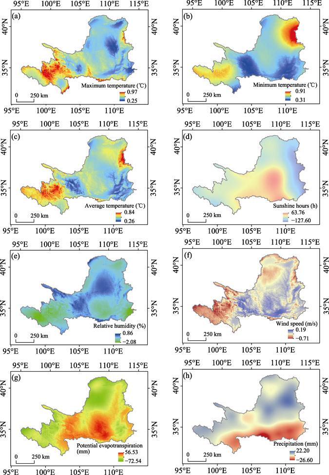
Figure 4 Spatial
distribution pattern of inter-annual variation of meteorological factors across
the Yellow River basin
empirical parameters as
and bs in the formula of solar radiation in different
regions, this study used pan evaporation as the target value of parameter
calibration. Therefore, the potential evapotranspiration in this study actually
refers to water surface evapotranspiration rather than land surface
evapotranspiration and represents the maximum evaporation capacity of the
region. The potential evapotranspiration in the current work is slightly
higher than that in previous studies[23–27]. However, these
values are basically consistent with those related to pan evaporation[28]. Furthermore,
Liao confirmed that the spatial distribution of pan evaporation and that of
potential evapotranspiration based on the P-M method are highly consistent[29]
and show a high correlation, which suggests that potential evapotranspiration
in the Yellow River basin can be estimated.
On
the basis of the observation data of meteorological stations, this study
developed the monthly/8-km grid meteorological dataset at the middle and upper
reaches of the Yellow River basin of China (1980–2015) and performed
generalized cross-validation. The climate characteristics, inter-annual
variation trends, and spatial distribution patterns of the middle and upper
reaches of the Yellow River basin were then analyzed. The main conclusions are
as follows:
(1)
The precision of spline interpolation based on ANUSPLIN is affected by station
distribution and seasonal variation. The error of interpolation is large
in regions with sparse meteorological stations at high altitudes. In terms
of temporal distribution, the interpolation accuracy for temperature,
relative humidity, and wind speed is higher in summer than in
winter. Meanwhile, the interpolation accuracy for sunshine hours,
precipitation, and potential evapotranspiration in summer is lower than that in
winter. The errors for sunshine hours, precipitation, and potential
evapotranspiration reach the maximum values in July, with the average values of
the first two factors being 22.6 h and 1.9 mm, respectively. The error for
potential evapotranspiration reaches the maximum value in May, with the average
value being 9.8 mm.
(2)
The climate conditions in the Yellow River basin have obvious spatial heterogeneity
and strong seasonal characteristics. The climate
characteristics of the Yellow River are as follows: a) low temperature,
long sunshine duration, high wind speed, and low potential evapotranspiration
for the source region; b) low precipitation and humidity for the northern
region; and c) high precipitation and humidity for the southern region.
Meanwhile, the climate characteristics of the middle reaches of the Yellow
River basin are as follows: a) the climate in the southeast is relatively
humid, with high temperature, short sunshine duration, low wind speed, large
precipitation, and small potential evapotranspiration; b) the climate in
northwestern China is dry and is characterized by low temperature in winter and
high temperature in summer, long sunshine duration, high wind speed, low
precipitation, and high potential evapotranspiration.
(3)
From 1980 to 2015, the climate in the Yellow River basin changed significantly.
The main characteristics are as follows: a) the temperature increased significantly
with an inter-annual change rate of 0.5 ºC/10a; b) the
relative humidity and wind speed showed a significant decreasing trend, and the
inter-annual change rates were −0.7%/10a and −0.1 m/(s·10a),
respectively; c) the inter-annual variation trends of sunshine duration,
precipitation, and potential evapotranspiration were not obvious.
Author Contributions
Luo, Y. provided general guidance for the research and
development of the dataset. Sun, L. calculated the potential
evapotranspiration, collected and sorted the data of the stations, and
extracted the boundaries of the middle and upper reaches of the Yellow River
basin. Li, H. Y. converted the interpolated data into the required
formats. Wang, Y. Q. performed spatial interpolation and prepared the data
papers.
Conflicts of Interest
The authors declare no conflicts of
interest.
References
[1]
Liu, Q.,
McVicar T. R., Yang, Z., et al. The
hydrological effects of varying vegetation characteristics in a temperate
water-limited basin: development of the dynamic Budyko-Choudhury-Porporato
(dBCP) model [J]. Journal of Hydrology,
2016, 543: 595–611.
[2]
Xia, J., Peng,
S. M., Wang, C., et al. Impact of
climate change on water resources and adaptive management in the Yellow River
basin [J]. Yellow River, 2014, 36(10): 1–4.
[3] Liu, C. M., Liu, X. M., Tian, W., et al. Ecological protection and
high-quality development of the Yellow River basin urgently need to solve the
water shortage problem [J]. Yellow River, 2020, 42(9): 6–9.
[4]
Huang, J.
P., Zhang, G. L, Yu, H. P., et al. Characteristics
of climate change in the Yellow River basin during recent 40 years [J]. Journal
of Hydraulic Engineering, 2020, 51(9): 1048–1058.
[5] Chen, Y., Wang, K., Lin,
Y., et al. Balancing green and grain
trade [J]. Nature Geoscience, 2015, 8:
739–741.
[6] Xiao, F. J., Xu, Y. Q., Huang, D. P., et al. Impact of climate change on
ecological security of the Yellow River basin and its adaptation countermeasures
[J]. Yellow River, 2021, 43(1): 10–14.
[7]
Zhao, J. H., Liu, C. S., Wang, G. Q., et al. Simulation and applicability study of different hydrological
models in Jinxi River basin[J]. Journal of North China University of Water
Resources and Electric Power, 2018, 39(3): 1–5.
[8]
Feng, X.,
Fu, B., Piao, S., et al. Revegetation
in China??s Loess Plateau is approaching sustainable water resource limits [J]. Nature Climate Change, 2016b, 6:
1019–1022.
[9]
Ye, P. L., Zhang, Q., Wang Y.,
et al.
Characteristics of climate change in the upper Yellow River basin and its
influence on vegetation and runoff during recent 40 years [J/OL]. Transactions
of Atmospheric Sciences: 1–21 [2021-05-21].
https://kns.cnki.net/kcms/detail/32.1803.P.20201104.1723.004.html.
[10] Zheng, Z.
Y., Lyu, M. X., Ma, Z. G. Climate, hydrology, and vegetation coverage changes
in source region of Yellow River and countermeasures for challenges [J]. Bulletin
of Chinese Academy of Sciences,
2020, 35(1): 61–72.
[11]
Guo, S., Pei, Y. X., Hu, S., et
al. Response of vegetation index to climate
change and their relationship with runoff-sediment change in Yellow River basin
[J]. Bulletin of Soil and Water Conservation, 2020, 40(3): 1–7.
[12] Liu Z., Tim, R. M., Li, L., et al. Interpolation for time series of meteorological
variables using ANUSPLIN [J]. Journal of Northwest A&F University (Science Edition), 2008(10): 227–234.
[13] Wu, L. Principle and Algorithm of Geographic
Information System [M]. Beijing: Science Press, 2003.
[14]
Sun, R. H., Liu, Q. L., Chen, L. D. Study on precipitation interpolation
based on the geostatistical analyst method [J]. Journal of China Hydrology,
2010, 30(1): 14–17.
[15] Yue, W. Z., Xu, J. H., Xu, L. H.
A Study on spatial interpolation methods for climate variables based on
geostatistics [J]. Plateau Meteorology, 2005(6): 974–980.
[16]
Liu, Z. H., Tim, R. M., Van, N., et al. Introduction of the professional interpolation software for meteorology data: ANUSPLIN [J]. Meteorlogical
Monthly, 2008(2): 92–100.
[17]
Hijmans, R.
J., Cameron, S. E., Parra, J. L., et al.
Very high resolution interpolated climate surfaces for global land areas [J]. International Journal of Climatology,
2005, 25: 1965–1978.
[18] Wang, Y. Q., Luo, Y., Shafeeque, M. Using
Gaussian Function to describe the seasonal courses of monthly precipitation and
potential evapotranspiration across the Yellow River Basin, China [J]. Journal of Hydrometeorology, 2019,
20(11): 2185–2201.
[19] Hutchinson, M. F. Anusplin Version 4.2 User
Guide [M]. Cauberra: Australian National University, 2001.
[20]
Wang, Y. Q., Sun L., Li H. Y., et
al. Monthly/8-km grid meteorological dataset at the middle and upper
reaches of the Yellow River basin of China (1980–2015) [J/DB/OL]. Digital
Journal of Global Change Data Repository. 2021. https://doi.org/10.3974/geodb.2021.07.09.V1. https://cstr.escience.org.cn/CSTR:20146.11.2021.07.09.V1.
[21]
GCdataPR
Editorial Office. GCdataPR data sharing policy [OL].
https://doi.org/10.3974/dp.policy. 2014.05 (Updated 2017).
[22]
Allen, R. G.,
Pereira, L. S., Raes, D., et al. Crop
evapotranspiration: guidelines for computing crop water requirements, in:
irrigation and drainage paper 56 [M]. Rome: Food and Agriculture Organization,
1998.
[23]
Li, Z. Applicability
of simple estimating method for reference crop evapotranspiration in Loess
Plateau [J]. Transactions of the Chinese Society of Agricultural Engineering,
2012a, 28(6): 106–111.
[24]
Li, Z. Spatiotemporal
variations in the reference crop evapotranspiration on the Loess Plateau during
1961–2009 [J]. Acta Ecologica Sinica, 2012b, 32 (13): 4139–4145.
[25]
Zhao, Y.,
Zou, X., Zhang, J., et al. Spatio-temporal
variation of reference evapotranspiration and aridity index in the Loess
Plateau region of China, during 1961–2012 [J]. Quaternary International, 2014, 349: 196–206. http:
//dx.doi.org/10.1016/j.quaint.2014.06.050.
[26] Li, Y., Liang, K., Bai, P.,
et al. The spatiotemporal variation
of reference evapotranspiration and the contribution of its climatic factors in
the Loess Plateau, China [J]. Environmental
Earth Sciences, 2016, 75: 354.
[27]
Ning, T. T.
The spatiotemporal variability of catchment evapotranspiration and its
attribution analysis in the Loess Plateau under the Budyko framework [D]. Yangling:
Research Center for Soil and Water Conservation and Eco-Environment, Ministry
of Education, Chinese Academy of Sciences, 2017.
[28]
Zhang, P.
F., Zhao, G. J., Mu, X. M., et al. Spatiotemporal
variation and driving factors of pan evaporation in the Weihe River basin [J]. Arid
Zone Research, 2019, 36(4): 973–979.
[29]
Liao, X. F.,
Qian, S., Peng, Y.
M., et al. Response of evaporation of evaporator and potential
evapotranspiration to the climate variation [J]. Yellow River, 2010, 32(11): 42–44.