Global Change Data Encyclopedia
Kotelny Island
Ni,
Y. N.1 Jing, H. Y.1 Zhang, F.1 Liu, C.2* Shi, R. X.2
1. School of
Earth Sciences, Zhejiang University, Hangzhou 310027, China;
2. Institute
of Geographic Sciences and Natural Resources Research, Chinese Academy of
Sciences, Beijing 100101, China
Keywords: Kotelny
Island; Bunge Island; Faddeyevsky Island; Russia; data encyclopedia
Dataset
Availability Statement:
The
dataset supporting this paper was published and is accessible through the Digital Journal of Global Change Data
Repository at: https://doi.org/10.3974/geodb.2020.03.04.V1.
Kotelny,
Faddeyevsky and Bunge Land are usually named as separate islands on most 20th
century maps, the Kotelny Island dataset here is identified as the gathering
island covering Kotelny, Faddeyevsky and Bunge Land. The Kotelny Island is
located in very north of Asia, near the Arctic Ocean. It is the largest island
in the Anjou (Anzhu) Islands subgroup, which is in the New Siberian Islands of
Russian Federation. The Kotelny Island is separated from New Siberia Island by
Blagovishensky channel in its east, separated from Lyakhovsky Islands by
Sannikov Strait in its south, and from the Belkovsky Island in its west. The
geo-location of the Kotelny Island is between 74??38ʹ1ʺN and 76??12ʹ15ʺN,
136??55ʹ48ʺE and 145??23ʹ46ʺE. The Kotelny Island belongs to Sakha (Yakutiya) of Russian
Federation. The area of the Kotelny Island is 23,741.32 km2 and the
coastline is 1,752.26 km long[1]. It has a harsh arctic climate, is hilly
in the western, and flat in the middle and eastern.
Kojelinee island
is in the polar climate zone, with an annual average temperature of -14.3 ??C, in July, 2.5 ??C, and in February, -29.8 ??C. The annual rainfall is about 130 mm. The ecological environment
is in the Arctic Antarctic mosses and lichens. In 1933, during
the first International Polar Year (IPY) (1932-1933), scientists established the Arctic observatory Station at the
Island (1933). Over the past decades, scientists have carried out a series of
research products on the island, including geology, geography, ocean, ecology,
environment and climate change, etc.
Makeyev, et al. indicated that the Kotelny Island consists of sedimentary rocks and
sediments ranging in age from Early Paleozoic to Late Cenozoic. The oldest rocks
are fossiliferous in shallow- to deep-water marine, and Ordovician to Early
Devonian limestones and dolomites. Middle Devonian to Carboniferous interbedded
limestones, dolomites, sandstones, and conglomerates overlie these sedimentary
strata. The Permian to Jurassic strata exposed within Kotelny Island consist of
interbedded, fossiliferous mudstones, siltstones, and sandstones. All of these
sedimentary rocks are faulted, folded into complex anticlines and synclines,
and intruded by thin diabase dikes. Pleistocene to Holocene fluvial sediments,
which range in age from 1,500 to greater than 55,000 radiocarbon years BP,
underlie stream terraces that lie within the Balyktakh and Dragotsennaya River
valleys. Thick permafrost has developed in these sediments[2].
Kos??ko and Trufanov
demonstrated that within Bunge Land and the southwest corner of Kotelny Island,
relatively unconsolidated sediments ranging in age from Early Cretaceous to
Holocene overlie the above folded and faulted sedimentary rocks. The oldest of
these sediments are Early Cretaceous alluvial clays, silts, and sands that
contain layers of conglomerate, tuff, tuffaceous sandstone, coal, and, at top,
rhyolite. The Late Cretaceous sediments are overlain by Late Eocene to Pliocene
alluvial sands that contain layers of clay, silt, gravel, brown coal, and
lignitized wood[3]. The vast majority of Bunge Land is blanketed by
Early Holocene marine sediments. Only in the central and southern parts of
Bunge Land do either Late to Early Pleistocene marine sediments or very small
patches of highly weathered Prequaternary deposits and bedrock underlie the
surface[4]. A military airport located on Kotelny Island can take
off and land large military transport aircraft such as Mi-26.
The dataset was
developed based on the ??Global multiple scale shorelines dataset based on
Google Earth images (2015)??[5], and the maps and references of
Russia Federation. The dataset is consisted of 15 data files and archived in
the .kmz and .shp data formats with data size of 2.51 MB (compressed to 1.75 MB
in two data files).
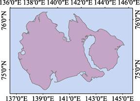
Figure
1 Map
of Kotelny Island (.shp format)
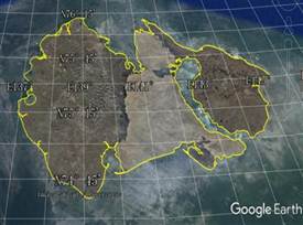
Figure 2 Map of Kotelny Island (.kmz format)
References
[1]
Ni, Y. N., Jing, H. Y., Zhang,
F., et al. Kotelny Island [J/DB/OL]. Digital Journal of Global Change Data
Repository, 2020. https://doi.org/10.3974/geodb.2020.03.04.V1.
[2]
Makeyev, V. M., Ponomareva, D. P.,
Pitulko, V. V., et al. Vegetation and
climate of the new siberian islands for the past 15,000 years [J]. Arctic, Antarctic, and Alpine Research, 2003, 35(1): 56?C66.
[3]
Kos??ko, M. K., Trufanov, G. V.
Middle cretaceous to eopleistocene sequences on the New Siberian Islands: an
approach to interpret offshore seismic [J]. Marine
and Petroleum Geology, 2002, 19(7): 901?C919.
[4]
Schirrmeister, L., Grosse, G.,
Kunitsky, V. V., et al. The mystery
of Bunge Land (New Siberian Archipelago)?Dimplications for its formation based
on palaeo-environmental records, geomorphology and remote sensing [R]. Quaternary
Science Reviews. https://doi.org/10.1016/j.quascirev.2009.11.017.
[5]
Liu, C., Shi, R. X., Zhang, Y.
H., et al. Global multiple scale
shorelines dataset based on Google Earth images (2015) [J/DB/OL]. Digital Journal of Global Change Data
Repository, 2019. https://doi.org/10.3974/geodb.2019.04.13.V1.