Global Change Data Encyclopedia
Aleutian Islands
Liu, C.1* Yang, A. Q.2 Hu, W. Y.1 Liu, R. G.1 Shi, R. X.1
1. Institute of Geographic Sciences and Natural Resources Research, Chinese Academy of Sciences, Beijing 100101, China;
2. Institute of Remote Sensing and Digital Earth??Chinese Academy of Sciences??Beijing100101??China
Keywords:Aleutian Islands; Fox Islands; Four Mountains Islands; Andreanof Islands; Rat Islands; Near Islands; Kommandor Islands; Unimak Island; USA; Russia; data encyclopedia
|
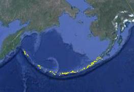
Figure 1 Dataset of Aleutian Islands in .kmz format
|
|
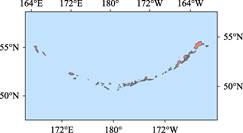
Figure 2 Dataset of Aleutian Islands in .shp format
|
The Aleutian Islands extends latitude from 51°12′35″N to 55°22′14″N and
longitude about 32 degrees from 165°45′10″E to 162°21′10″W, it is a chain volcanic islands belonging to both the United States and Russia[1–3] (Figure 1, 2). The islands are formed in the northern part of the Pacific Ring of Fire. They form part of the Aleutian Arc in the Northern Pacific Ocean, extending about 1,900 km westward from the Alaska Peninsula toward the Kamchatka Peninsula in Russia, and mark a dividing line between the Bering Sea to the north and the Pacific Ocean to the south. The islands comprise 6 groups of islands (east to west): the Fox Islands[4–5], islands of Four Mountains[6–7], Andreanof Islands[8–9], Rat Islands[10–11], Near Islands[12–13] and Kommandor Islands[14–15]. The first 5 islands belong to the United States, and the extreme western end, the small, geologically related Kommandor Islands belong to Russia. The Aleutian Islands occupy a total area of 17,653.73 km2 and the total coastline is 8,605.12 km. There are total 2,030 islands, including 49 islands with area great than 10 km2 and 24 island with area great than 100 km2. The largest islands in the Aleutians are Attu (the furthest from the mainland), and Unalaska, Umnak, and Unimak in the Fox Islands. The largest of those is Unimak Island, with an area of 4,077.93 km2, followed by Unalaska Island with an area of 2,724.71 km2 and the longest coastline 1,063.46 km. Aleutian Islands are composed by 6 islands, i.e., Fox Islands, Islands of Four Mountains, Andreanof Islands, Rat Islands Near Islands, and Kommandor Islands. The geo-location, area, coastline of these main islands of Aleutian Islands are shown in Table 1.
Table 1 Main islands of Aleutian Islands
|
Name of islands[16]
|
Geo-location
|
Area (km2)
|
Coastline (km)
|
|
Fox Islands
|
52°46′0″N-55°3′9″N, 162°21′10″W-169°15′7″W
|
9,559.52
|
3,138.67
|
|
Islands of Four Mountains
|
52°26′40″N-53°5′1″N, 169°39′40″W-171°18′56″W
|
548.92
|
349.78
|
|
Andreanof Islands
|
52°12′35″N-52°25′12″N, 172°17′45″W-179°8′60″W
|
3,991.47
|
3,097.89
|
|
Rat Islands
|
51°20′54″N-52°8′10″N, 177°11′52″E-179°46′24″E
|
974.14
|
873.69
|
|
Near Islands
|
52°20′5″N-53°0′42″N, 172°27′45″E-175°58′29″E
|
1,166.78
|
615.89
|
|
Kommandor Islands
|
54°29′45″N-55°22′14″N, 165°45′10″E-168°6′9″E
|
1,412.71
|
526.95
|
|
Total
|
|
17,653.73
|
8,605.12
|
Table 2 Main islands of Fox Islands
|
Name of islands[16]
|
Geo-location
|
Area (km2)
|
Coastline (km)
|
|
Unimak Island
|
54º23′20″N-55º3′9″N, 164º56′48″W-163º2′35″W
|
4,077.93
|
517.36
|
|
Unalaska Island
|
53º13′58″N-54º1′9″N, 167º51′14″W-166º12′21″W
|
2,724.71
|
1,063.46
|
|
Umnak Island
|
52º49′11″N-53º34′1″N, 169º7′1″W-167º47′6″W
|
1,786.40
|
452.48
|
|
Akutan Island
|
54º1′59″N-54º13′37″N, 166º6′59″W-165º39′28″W
|
332.35
|
132.43
|
|
Akun Island
|
54º6′20″N-54º17′54″N, 165º41′15″W-165º23′6″W
|
162.60
|
121.81
|
|
Sanak Island
|
54º22′10″N-54º29′29″N, 162º50′11″W-162º31′57″W
|
121.84
|
96.81
|
|
Sedanka Island
|
53º42′22″N-53º51′23″N, 166º18′38″W-166º5′9″W
|
101.85
|
92.45
|
|
Tigalda Island
|
54º3′49″N-54º8′15″N, 165º13′13″W-164º55′9″W
|
95.09
|
97.55
|
|
Avatanak Island
|
54º2′17″N-54º5′56″N, 165º28′59″W-165º14′1″W
|
36.74
|
49.10
|
|
Unalga Island
|
51º34′6″N-51º35′23″N, 179º3′49″W-179º1′57″W
|
26.89
|
28.84
|
|
Caton Island
|
54º22′2″N-54º25′8″N, 162º28′56″W-162º21′11″W
|
18.57
|
28.19
|
|
Rootok Island
|
54º1′25″N-54º4′1″N, 165º34′26″W-165º28′57″W
|
13.16
|
19.22
|
|
Ugamak Island
|
54º11′26″N-54º13′48″N, 164º53′5″W-164º45′45″W
|
11.22
|
31.18
|
|
Amaknak Island
|
53º51′58″N-53º55′35″N, 166º34′00″W-166º30′9″W
|
8.77
|
29.70
|
|
Long Island
|
54º23′8″N-54º26′7″N, 162º51′43″W-162º47′24″W
|
6.65
|
23.22
|
|
Samalga Island
|
52º46′2″N-52º48′13″N, 169º14′51″W-169º9′32″W
|
3.90
|
15.39
|
|
Ogangen Island
|
53º25′39″N-53º27′44″N, 166º53′11″W-166º51′52″W
|
3.17
|
10.28
|
|
Elma Island
|
54º21′41″N-54º22′33″N, 162º31′7″W-162º27′2″W
|
2.95
|
10.90
|
|
Vsevidof Island
|
52º58′32″N-52º59′31″N, 168º29′12″W-168º26′52″W
|
2.19
|
12.44
|
|
Clifford Island
|
54º22′20″N-54º23′35″N, 162º47′24″W-162º45′43″W
|
1.73
|
8.80
|
|
Aiktak Island
|
54º10′42″N-54º11′23″N, 164º50′53″W-164º48′55″W
|
1.51
|
10.28
|
|
Anangula Island
|
52º59′39″N-53º0′47″N, 168º55′23″W-168º53′45″W
|
1.43
|
7.49
|
|
Egg Island
|
53º51′21″N-53º52′9″N, 166º3′41″W-166º2′18″W
|
1.30
|
6.52
|
The Fox Islands are the eastern islands in the Aleutian Islands chain in Alaska, east of the Samalga Pass and islands of Four Mountains. The larger islands of the Fox Islands from west to east are Umnak, Unaraska, Amaknak, Akutan, Akun, Unimak and Sanak (Table 2). The largest area of Unimak is 4,077.93 km2, and the longest coastline is 1,063.46 km of Unaraska. Fox Islands have a total of 23 islands more than 1 km2, 7 more than 100 km2. The Fox Islands have a total area of 9,559.52 km2 and a total coastline of 3,138.67 km.
The islands of Four Mountains are an archipelago in southwest Alaska and part of the Aleutian Islands. The islands of Four Mountains are bounded by the Fox Islands to the east and the Andreea Islands to the west, between the Pacific Ocean and the Bering Sea. There are mainly 8 islands in the Four mountain Islands, from west to east are Amukta Island, Chagulak Island, Yunaska Island, Chuginadak Island, Uliaga Island, Gagamil Island (Table 3). The largest area of the Island is Yunaska, 172.18 km2 and the smallest area is Chagulak Island, 8.6 km2. The longest coastline of Island is Chuginadak, 98.95 km.
The total area of the islands of Four Mountains is 548.92 km2, and the total length of the coastline is 349.78 km.
Table 3 Main islands of islands of Four Mountains
|
Name of islands[16]
|
Geo-location
|
Area (km2)
|
Coastline (km)
|
|
Yunaska Island
|
52º32′35″N-52º42′5″N, 170º50′45″W-170º33′23″W
|
172.18
|
74.80
|
|
Chuginadak Island
|
52º46′20″N-52º53′40″N, 170º0′49″W-169º40′2″W
|
170.06
|
98.93
|
|
Herbert Island
|
52º43′1″N-52º47′29″N, 170º11′13″W-170º3′5″W
|
54.19
|
36.57
|
|
Amukta Island
|
52º26′54″N-52º31′51″N, 171º18′56″W-171º11′44″W
|
50.05
|
41.84
|
|
Carlisle Island
|
52º51′26″N-52º55′29″N, 170º7′29″W-169º59′36″W
|
42.22
|
30.57
|
|
Gagamil Island
|
52º56′46″N-53º2′8″N, 169º45′52″W-169º39′40″W
|
42.13
|
32.46
|
|
Uliaga Island
|
53º2′46″N-53º5′1″N, 169º47′59″W-169º44′24″W
|
9.38
|
15.32
|
|
Chagulak Island
|
52º33′27″N-52º35′11″N, 171º10′38″W-171º6′55″W
|
8.61
|
14.03
|
The Andreanof islands are islands in southwest Alaska and is part of the Aleutian Islands. The Andreanof Islands are bounded by the islands of Four Mountains to the east and the Rat Islands to the west. They are generally located in the middle of the Aleutian Islands between the Pacific Ocean and the Bering Sea. There are 577 islands larger than 100 m2 in the Andreea. Among them, one island with an area greater than 1,000 km2 and 37 islands with an area larger than 1 km2 (Table 4). The total area of the island is 3,991.47 km2 and the total coastline is 3,098.02 km2 long. The largest island is Atka Island, with an area of 1,055.43 km2.
The other main islands of the Andreanof Islands are Adak Island, Anaga Island, Amulia Island, Kanaga Island, Seguam Island, Great Sitkin Island, Kagalaska Island, Little Tanaga Island, Gareloi Island, Umak Island, Amatignak Island, Ulak Island, Igitkin Island, Chugul Island, Kavalga Island, Tagalak Island, Ogliuga Island, Bobrof Island, Kasatochi Island, Skagul Island, Tanaklak Island, Kanu Island, Elf Island, Unalga Island, Tagadak Island, Ilak Island, Ringgold Island, Asuksak Island, Sadatanak Island, Solt Island, Dora Island, Asiak Island, Koniuji Island.
The Lat Islands are volcanic islands belonging to the Aleutian Islands, southwest of Alaska, the Near Islands to its west, and the Andreanof Islands to the east. The larger islands from west to east are Kiska Island, Little Kiska Island, Segula Island, Khvostof Island, Davidof Island, Little Sitkin Island, Amchitka Islan, Semisopochuoi Island (Table 5). The largest island is Amchitka (319.87 km2) and the island has a longest coastline of 304.12 km. The island has a total area of 974.18 km2 and a total coastline of 873.7 km.
Table 4 Main islands of Andreanof Islands
|
Name of islands[16]
|
Geo-location
|
Area (km2)
|
Coastline (km)
|
|
Atka Island
|
51º59′59″N-52º25′12″N, 175º20′31″W-173º59′16″W
|
1055.39
|
651.62
|
|
Adak Island
|
51º35′22″N-52º0′7″N, 176º59′43″W-176º25′6″W
|
720.48
|
454.25
|
|
Tanaga Island
|
51º35′42″N-51º55′13″N, 178º13′46″W-177º36′58″W
|
517.21
|
240.31
|
|
Amulia Island
|
52º1′15″N-52º9′35″N, 174º3′17″W-172º57′13″W
|
458.90
|
309.57
|
|
Kanaga Island
|
51º39′9″N-51º56′37″N, 177º42′33″W-177º2′52″W
|
368.70
|
259.42
|
|
Seguam Island
|
52º14′49″N-52º23′33″N, 172º38′00″W-172º17′45″W
|
207.35
|
88.40
|
|
Great Sitkin Island
|
51º58′1″N-52º7′3″N, 176º12′46″W-175º58′19″W
|
154.21
|
78.24
|
|
Kagalaska Island
|
51º43′36″N-51º52′21″N, 176º25′34″W-176º15′54″W
|
118.60
|
106.95
|
|
Little Tanaga
Island
|
51º46′9″N-51º53′2″N, 176º14′10″W-175º59′45″W
|
71.39
|
97.18
|
|
Gareloi Island
|
51º44′44″N-51º50′18″N, 178º52′26″W-178º44′1″W
|
67.63
|
34.04
|
|
Umak Island
|
51º50′46″N-51º54′48″N, 176º7′7″W-175º57′2″W
|
37.91
|
52.55
|
|
Amatignak Island
|
51º12′51″N-51º18′10″N, 179º9′00″W-179º3′27″W
|
35.59
|
39.27
|
|
Ulak Island
|
51º18′20″N-51º24′11″N, 179º0′16″W-178º54′21″W
|
31.53
|
45.70
|
|
Igitkin Island
|
51º57′50″N-51º51′59″N, 175º57′48″W-175º48′25″W
|
19.26
|
35.10
|
|
Chugul Island
|
51º54′52″N-51º57′39″N, 175º52′40″W-175º45′34″W
|
17.88
|
33.12
|
|
Kavalga Island
|
51º32′21″N-51º34′43″N, 178º51′49″W-178º44′1″W
|
15.53
|
40.23
|
|
Tagalak Island
|
51º55′55″N-51º58′33″N, 175º44′50″W-175º38′53″W
|
14.70
|
26.80
|
|
Ogliuga Island
|
51º35′6″N-51º36′56″N, 178º41′16″W-178º36′37″W
|
10.49
|
27.09
|
|
Bobrof Island
|
51º53′16″N-51º55′38″N, 177º28′11″W-177º25′3″W
|
7.76
|
14.79
|
|
Kasatochi Island
|
52º9′18″N-52º11′10″N, 175º31′51″W-175º29′24″W
|
7.03
|
11.08
|
|
Skagul Island
|
51º34′50″N-51º36′29″N, 178º36′36″W-178º33′43″W
|
5.20
|
21.84
|
|
Tanaklak Island
|
51º56′51″N-51º57′50″N, 176º8′17″W-176º5′19″W
|
3.82
|
10.77
|
|
Kanu Island
|
51º55′44″N-51º57′20″N, 176º3′25″W-176º1′34″W
|
3.73
|
11.50
|
|
Elf Island
|
51º41′57″N-51º43′56″N, 176º32′39″W-176º30′58″W
|
3.10
|
17.28
|
|
Unalga Island
|
53º57′8″N-53º59′57″N, 165º12′00″W-166º4′29″W
|
2.65
|
14.43
|
|
Sagchudak Island
|
52º0′32″N-52º2′1″N, 174º30′1″W-174º28′35″W
|
2.37
|
10.70
|
|
Tagadak Island
|
51º56′41″N-51º57′50″N, 176º1′12″W-175º59′31″W
|
2.29
|
7.05
|
|
Oglodak Island
|
51º58′37″N-51º59′26″N, 175º28′13″W-175º25′53″W
|
1.82
|
10.36
|
|
Ilak Island
|
51º28′20″N-51º29′1″N, 178º18′14″W-178º16′25″W
|
1.54
|
6.20
|
|
Ringgold Island
|
51º47′48″N-51º48′30″N, 176º50′31″W-176º48′20″W
|
1.49
|
7.39
|
|
Asuksak Island
|
51º55′44″N-51º56′30″N, 176º6′53″W-176º5′37″W
|
1.34
|
5.27
|
|
Sadatanak Island
|
52º1′36″N-52º2′21″N, 174º26′31″W-174º24′42″W
|
1.32
|
7.47
|
|
Solt Island
|
52º9′56″N-52º10′51″N, 174º39′20″W-174º37′34″W
|
1.27
|
8.46
|
|
Dora Island
|
51º48′27″N-51º49′14″N, 176º48′26″W-176º46′39″W
|
1.27
|
9.59
|
|
Asiak Island
|
51º56′43″N-51º57′25″N, 176º10′14″W-176º8′39″W
|
1.26
|
7.67
|
|
Koniuji Island
|
52º12′53″N-52º13′39″N, 175º8′30″W-175º7′25″W
|
1.06
|
5.27
|
The Near Islands are the westernmost islands of Aleutian Islands, the Commander Islands of the Russian Aleutian Islands to the west, the American Rat Islands to the east, and the north-south between the Bering Sea and the Pacific Ocean. Attu and Agattu are the two largest islands. In addition to some of the reefs between Attu Island and Agatu Island, the other larger island is Semichi Island, including Alaid Island, Nizki Island and Shemya Island. Buldir Island is located at the easternmost tip of Near Islands. There are 6 islands with an area of more than 1 km2 in the Near Islands (Table 6). The largest island is Attu with an area of 887.97 km2. It is also the island with longest coastline, 317.37 km.
The total area of Near Islands is 1,166.83 km2 and a total coastline, 616.05 km.
Table 5 Main islands of Lat Islands
|
Name of islands[16]
|
Geo-location
|
Area (km2)
|
Coastline (km)
|
|
Amchitka Island
|
51º20′54″N-51º40′00″N, 178º36′27″E-179º28′13″E
|
319.86
|
304.12
|
|
Kiska Island
|
51º49′32″N-52º8′10″N, 177º11′52″E-177º40′30″E
|
280.23
|
214.31
|
|
Semisopochuoi Island
|
51º52′15″N-52º1′38″N, 179º28′18″E-179º46′24″E
|
223.04
|
78.03
|
|
Little Sitkin Island
|
51º53′42″N-51º59′42″N, 178º25′26″E-178º35′33″E
|
68.76
|
64.89
|
|
Segula Island
|
51º59′12″N-52º3′10″N, 178º5′16″E-178º11′25″E
|
33.55
|
35.79
|
|
Rat Island
|
51º45′36″N-51º50′10″N, 178º12′20″E-178º23′13″E
|
29.78
|
48.94
|
|
Little Kiska Island
|
51º56′28″N-51º58′23″N, 177º37′10″E-177º42′25″E
|
7.91
|
21.48
|
|
Davidof
|
51º56′43″N-51º58′37″N, 178º18′53″E-178º21′58″E
|
3.75
|
15.48
|
|
Khvostof Island
|
51º58′6″N-51º59′13″N, 178º15′44″E-178º18′13″E
|
2.64
|
9.02
|
|
Bird Rock
|
51º39′17″N-51º40′7″N, 178º37′8″E-178º38′31″E
|
1.43
|
9.92
|
Table 6 Main islands of Near Islands
|
Name of islands[16]
|
Geo-location
|
Area (km2)
|
Coastline (km)
|
|
Attu Island
|
52º44′40″N-53º0′42″N, 172º27′45″E-173º25′54″E
|
887.93
|
317.25
|
|
Agattu Island
|
52º21′17″N-52º30′48″N, 173º20′59″E-173º46′33″E
|
227.57
|
140.63
|
|
Buldir Island
|
52º20′5″N-52º22′33″N, 175º52′6″E-175º58′29″E
|
19.38
|
21.60
|
|
Shemya Island
|
52º42′12″N-52º44′31″N, 174º3′7″E-174º9′26″E
|
15.56
|
26.75
|
|
Nizki Island
|
52º43′7″N-52º45′10″N, 173º56′36″E-174º1′17″E
|
8.06
|
23.70
|
|
Alaid Island
|
52º44′42″N-52º46′30″N, 173º51′35″E-173º56′33″E
|
6.80
|
19.44
|
The Kommandor Islands locate in the westernmost end of Aleutian Islands. They are part of the Bering Islands of Russia and 175 km from the eastern part of Kamchatka Peninsula in the far East of Russia. The Kommandor Islands include Bering, Medey, two largest islands and some small islands and reefs. These small islands, among the reefs, Kamen Toporkov are the largest reef. The area of Bering Island and Medell Island are 1,187.4 and 224.84 km2, and the coastline are 310.84 and 197.79 km, respectively. The area of Kamen Toporkov reef is 0.19 km2 and the coastline is 1.74 km.
The total area of Kommandor Islands is 1,412.71 km2 and a total coastline is 526.95 km.
Table 7 Main islands of Kommandor Islands
|
Name of islands[16]
|
Geo-location
|
Area (km2)
|
Coastline (km)
|
|
Bering Island
|
54º40′42″N-55º22′14″N, 165º45′10″E-166º40′47″E
|
1,187.41
|
310.84
|
|
Medny Island
|
54º29′45″N-54º52′10″N, 167º26′12″E-168º6′9″E
|
224.84
|
197.79
|
The Aleutian Islands dataset was developed based on integration among the Google Earth images and related maps and records. The dataset is archived in the .shp and .kmz data formats with the compressed data size of 27.5 MB.
References
[1] Liu, C., Yang, A. Q., Hu, W. Y., et al. Aleutian Islands [DB/OL]. Global Change Research Data Publishing & Repository, 2016. DOI: 10.3974/geodb.2016.08.12.V1.
[2] Wikipedia. Aleutian Islands [Z]. https://en.wikipedia.org/wiki/Aleutian_Islands.
[3] Aleutian Islands. The World Book Encyclopedia (Volume 11) [M]. Field Enterprises Educational Cooperation, USA. 1976, 324.
[4] Liu, C., Yang, A. Q., Hu, W. Y., et al. Fox Islands [DB/OL]. Global Change Research Data Publishing & Repository, 2016. DOI: 10.3974/geodb.2016.08.05.V1.
[5] Wikipedia. Fox Islands [Z]. https://en.wikipedia.org/wiki/Fox_Islands
[6] Liu, C., Yang, A. Q., Hu, W. Y., et al. Four Mountains Islands [DB/OL]. Global Change Research Data Publishing & Repository, 2016. DOI: 10.3974/geodb.2016.08.04.V1.
[7] Wikipedia. Islands of Four Mountains [Z]. https://en.wikipedia.org/wiki/Islands_of_Four_Mountains.
[8] Liu, C., Yang, A. Q., Hu, W. Y., et al. Andreanof Islands [DB/OL]. Global Change Research Data Publishing & Repository, 2016. DOI: 10.3974/geodb.2016.08.03.V1.
[9] Wikipedia. Andreanof Islands [Z]. https://en.wikipedia.org/wiki/Andreanof_Islands
[10] Liu, C., Yang, A. Q., Hu, W. Y., et al. Rat Islands [DB/OL]. Global Change Research Data Publishing & Repository, 2016. DOI: 10.3974/geodb.2016.08.09.V1.
[11] Wikipedia. Rat Islands [Z]. https://en.wikipedia.org/wiki/Rat_Islands.
[12] Liu, C., Yang, A. Q., Hu, W. Y., et al. Near Islands [DB/OL]. Global Change Research Data Publishing & Repository, 2016. DOI: 10.3974/geodb.2016.08.07.V1.
[13] Wikipedia. Near Islands [Z]. https://en.wikipedia.org/wiki/Near_Islands.
[14] Liu, C., Yang, A. Q., Hu, W. Y., et al. Commander Islands [DB/OL]. Global Change Research Data Publishing & Repository, 2016. DOI: 10.3974/geodb.2016.08.11.V1.
[15] Wikipedia. Commander Islands [Z]. https://en.wikipedia.org/wiki/Commander_Islands
[16] Department of the Interior, U.S. Geological Survey [Z]. Geographical Names Information System (GNIS). https://geonames.usgs.gov/apex/f?p=138:2:0::NO:RP::.