Navigable Window Dataset of the Arctic Northeast Passage (2006–2015)
Ma, L.1* An, L.1 Zhang, X. H.1 Zheng, Z. Y.1 Li, Z. H.2 Chen, G. W.3
1. Navigation College, Dalian Maritime University, Dalian 116026, China;
2. Panjin Entry-Exit Inspection and Quarantine Bureau, Panjin 124010, China;
3. The Third Surveying and Mapping Institute of Guizhou Province, Guiyang 550004, China
Abstract: The navigable window means the start date, the end date, and the navigable period of the passage sailing by one ship without the sea ice affecting the safety of navigation. Based on the route of M/V Yongsheng owned by China COSCO Shipping Corporation Limited in her virgin voyage of the Arctic Northeast Passage in 2013, the daily sea ice concentration data from 2006 to 2015 produced by the University of Bremen was utilized to extract the navigable window dataset of the Arctic Northeast Passage. The start date of the navigable window of the route was the first day of 3 consecutive days with sea ice concentration lower than 40%, while the end date was the last day of the 3 consecutive days with sea ice concentration higher than 40%. The dataset includes: (1) the vector data of the route of the M/V Yongsheng in her virgin voyage of the Arctic Northeast Passage in 2013; (2) the navigable window dataset of the Arctic Northeast Passage from 2006 to 2015, including the start date, the end date, and the navigable period. The dataset was stored in .shp, .kmz, and .xlsx formats and consisted of 6 files with a data size of 295 KB (compressed to 2 files, 262 KB). The corresponding research was published in Chinese Journal of Polar Research, 2018, Volume 30, Issue 2. The main results included the basic situation of the navigable window of the Arctic Northeast Passage in the last 10 years, the navigability of the Passage, and the location of the main ice barriers.
Keywords: the Arctic Pole; Northeast Passage; navigable window; Chinese Journal of Polar Research
1 Introduction
With the Arctic sea ice continuing melting, the development and utilization of the Arctic Northeast Passage is promising, which can save 15%–50% of voyage compared with the traditional passage[1]. However, the sea ice condition affects the navigability of the Arctic Northeast Passage, and is one of the key elements for the strategic and economic considerations of the Arctic Northeast Passage. There are few studies on the sea ice conditions along the Arctic Northeast Passage, especially for specific commercial routes. Therefore, it is necessary to study the sea ice conditions of the Arctic Northeast Passage. The sea ice concentration data from 2006 to 2015 produced by the PHAROS team of the University of Bremen, Germany[2] were adopted in this dataset; and based on the route taken by M/V Yongsheng in her virgin voyage of the Arctic Northeast Passage in 2013, we determined the navigable window dataset and analyzed the navigable conditions of the Arctic Northeast Passage[1]. This dataset can support the Chinese government to take diplomatic and commercial decision to protect China’s rights and interests in the Arctic. It also helps shipping companies to use the navigable window dataset of the Arctic Northeast Passage for voyage planning and decision-making, and provides an important reference for sailing in these waters.
2 Metadata of Dataset
The metadata of the “Navigation window data of the Arctic Northeast Passage during 2006–2015”[3] are shown in Table 1, including the dataset name, authors, geographic region, year of dataset, data format, data size, data files, data publisher, data sharing policy, etc.
Table 1 Metadata summary of the “Navigation window data of the Arctic Northeast Passageduring 2006–2015”
|
Item
|
Description
|
|
Dataset full name
|
Navigation window data of the Arctic Northeast Passage during 2006–2015
|
|
Dataset short name
|
NavigationWindowArcticNEPassage_2006-2015
|
|
Authors
|
Ma, L. L-5862-2016, Navigation College, Dalian Maritime University, malong@dlmu.edu.cn
An, L., Academy of Navigation, Dalian Maritime University, 823666164@qq.com
Zheng, Z. Y., Navigation College, Dalian Maritime University, dlzzyi@dlmu.edu.cn
Zhang, X. H., Academy of Navigation, Dalian Maritime University, jensy@dlmu.edu.cn
Li, Z. H., Panjin Entry-Exit Inspection and Quarantine Bureau, dmulizhenhua@163.com
Chen, G. W., the Third Surveying and Mapping Institute of Guizhou Province, chenguanwen127@126.com
|
|
Geographical region
|
the Arctic Northeast Passage Year 2006–2015
|
|
Data format
|
.shp, .kmz, .xlsx, .prj, .shx, .dbf Data size 295 KB (compressed to 2 files, 262 KB)
|
|
Data files
|
The dataset consists of 6 files, as explained below:
(1) The route vector data of M/V Yongsheng in her virgin voyage of the Arctic Northeast Passage: the data format is .kmz, and the data size is 1.29 KB
(2) The route vector data of M/V Yongsheng in her virgin voyage of the Arctic Northeast Passage: the data format is .shp
(3) The route vector data of M/V Yongsheng in her virgin voyage of the Arctic Northeast Passage: the data format is .shx
(4) The route vector data of M/V Yongsheng in her virgin voyage of the Arctic Northeast Passage: the data format is .prj
(5) The route vector data of M/V Yongsheng in her virgin voyage of the Arctic Northeast Passage: the data format is .dbf
(6).xlsx file: the navigable window data of the Arctic Northeast Passage during 2006-2015 with the data format of .xlsx
|
|
Foundations
|
Ministry of Education of P. R. China (3132015008, 3132016360); Liaoning Provincial Department of Education (L2014202); Ministry of Transport of P. R. China (2014-322- 255-190)
|
|
Data publisher
|
Global Change Research Data Publishing & Repository, http://www.geodoi.ac.cn
|
|
Address
|
No.11, Datun Road, Chaoyang District, Beijing 100101, China
|
|
Data sharing policy
|
Data from the Global Change Research Data Publishing & Repository includes metadata, datasets (data products), and publications (in this case, in the Journal of Global Change Data & Discovery). Data sharing policy includes: (1) Data are openly available and can be free downloaded via the Internet; (2) End users are encouraged to use Data subject to citation; (3) Users, who are by definition also value-added service providers, are welcome to redistribute Data subject to written permission from the GCdataPR Editorial Office and the issuance of a Data redistribution license, and; (4) If Data are used to compile new datasets, the ‘ten percent principal’ should be followed such that Data records utilized should not surpass 10% of the new dataset contents, while sources should be clearly noted in suitable places in the new dataset[4]
|
|
Communication and searchable system
|
DOI, DCI, CSCD, WDS/ISC, GEOSS, China GEOSS
|
3 Data Development Method
3.1 Data Sources
This dataset was derived from the daily sea ice concentration product during 2006–2015 produced by the PHAROS (Physical Analysis of Remote Sensing Images) team at the University of Bremen, Germany[2], with a spatial resolution of 6.25 km. Due to the discontinuity of satellites, the sea ice concentration product was actually made from three microwave data: AMSR-E data (2003–2011), SSMIS/DMSP data (October 2011–August 2012) and AMSR-2 Data (since August 2012)[5].
3.2 Algorithm Principle
|
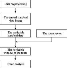
Figure 1 Technical route of data development
|
The navigable window means the start date, the end date, and the navigable period of the passage sailing by one ship without the sea ice affecting its safety of navigation. The start date of the navigable window of the route was the first day of 3 consecutive days with sea ice concentration lower than 40%, while the end date was the last day of 3 consecutive days with sea ice concentration higher than 40%. The sea ice concentration represents the navigability of ice waters. Considering the icebreaking capacity of M/V Yongsheng, 40% was chosen as the threshold of sea ice concentration to extract the navigable window of the route. The original extracted navigable window was further checked to eliminate the influence of the polynya and the drift ice.
3.3 Technical Route
The technical route for extracting the navigable window is shown in Figure 1.
(1) Data preprocessing mainly included two parts: the first was to compile the annual sea ice concentration data into one dataset, which might contain 365 or 366 bands; and the second was to unify the coordinate system of all data. After the preprocessing, ten datasets were obtained.
(2) The annual start date image and end date image were developed during 2006–2015 according to the navigable window algorithm.
(3) By overlaying the route vector data of M/V Yongsheng in her virgin voyage of the Arctic Northeast Passage with the annual start date image and end date image respectively, the start date, the end date, and the navigable period of each pixel along the route were extracted, i.e., the navigable window of the Arctic Northeast Passage.
4 Result and Verification
4.1 Data Composition
The navigable window dataset of the Arctic Northeast Passage from 2006 to 2015 included six documents as follows:
(1) The navigable window dataset of the Arctic Northeast Passage from 2006 to 2015 in .xlsx format (Figure 2 and Figure 3): archiving the navigable window data of the Arctic Northeast Passage, including the start date, end date, and the navigable period before and after correcting the influence of the polynya and the drift ice.
(2) The route vector data of M/V Yongsheng in her virgin voyage of the Arctic Northeast Passage in .kmz format (Figure 4).
(3) The remaining four documents were the route vector related data files in .shp, .shx, .prj, and .dbf formats, and were compressed into one file with the navigable window data together.
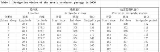
Figure 2 The navigable window dataset (.xlsx format) of the Arctic Northeast Passage in 2006
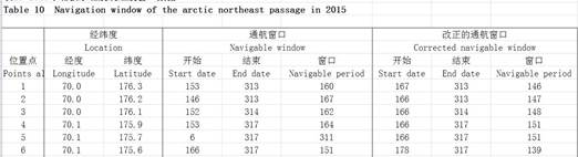
Figure 3 The navigable window dataset (.xlsx format) of the Arctic Northeast Passage in 2015
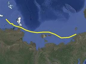
Figure 4 The route vector data visualization of M/V Yongsheng in her virgin voyage
4.2 Data Validation
According to the navigable window algorithm, the navigable window of M/V Yongsheng route was developed (Figure 5) after eliminating the influence of the polynya and the drift ice. The abscissa in Figure 2 is the geographic location of the route, with a total of 431 pixels, while the vertical coordinate is the number of days counted from the first day of the year. For the abscissa, 1–91 pixels were located in the East Siberian Sea, 192–237 pixels were located in the Arctic Ocean, 238–335 pixels were located in the Laptev Sea, and 336–431 pixels were located in the Kara Sea.
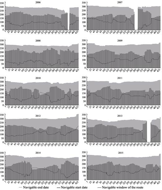
Figure 5 The navigable window of the waters in the M/V Yongsheng route from 2006 to 2015[5]
The sea ice conditions in the leg A are basically not affected by the sub-Arctic warm current, but mainly by the runoff of the land rivers. Without the influence of the ocean warmcurrent, the effect of land runoff on the melting of sea ice is very limited[6]. The sea ice conditions of leg B are very sensitive to the change of the sea ice in the Arctic Ocean waters. That is, the navigable window is long in the year when the sea ice is mild, and is greatly shortened in the year when the sea ice is serious. The dynamic extent of sea ice is highly variable in the waters around the middle section of the Villikitsky Strait extending westward about 220 km, mainly because the strong offshore wind in summer promotes the drift and accumulation of coastal sea ice to the water where the ice has already melted, which causes the sea ice to change rapidly in a short time[7]. The sea ice conditions in the western waters of the Laptev Sea are not in line with the changing trend of the entire Arctic Ocean waters. Even in 2013 when the sea ice conditions were most serious, the navigable window reached the longest in these waters.
The key waters and their sea ice conditions identified in this paper are consistent with the previous research. The book Arctic Navigation Guide (Northeast Passage)[8] states that the Villikitsky Strait (the central part of leg B) is a key point for the navigation of the Northeast Passage, and there is often a large amount of sea ice accumulation in and around the strait in summer hindering the navigation of the ship, especially in the absence of icebreaker escort[9]. The two key waters of leg A and B are also confirmed in the study of Zhao and Yang[10] and Meng et al.[9].
The knowledge of the sea ice conditions acquired in this study is also in line with the description of the sea ice conditions of the passage by Zhao who was on M/V Yongsheng in her virgin voyage[11–12]. Captain Zhao pointed out in his voyage diary that M/V Yongsheng was affected by ice floes in the East Siberian Sea (leg A), and the Vlikitsky Strait and the Kara Sea (leg B). The sea ice concentrations of the East Siberian Sea were 30%–40% with scattered ice. The ship altered its course according to the sea ice conditions, and the sea ice had no effect on the navigation safety of M/V Yongsheng basically. The sea ice concentrations in the Kara waters were about 60%–80%. The ice was mostly the ice of the year, while a small part was the multiyear ice with 0.5–1.3 m thick. It was difficult for M/V Yongsheng to sail alone without the icebreaker.
4.3 Discussion
From Figure 2, the basic situation of the navigable window of the M/V Yongsheng route from 2006 to 2015 could be obtained. The fluctuation of the navigable period in 10 years was relatively large, and there was no stable trend. Except for the average navigable start date of 2008 later than other years, and the average end date of 2013 earlier, the average navigable start date of the other years was in mid-early of July, and the average end date was in the mid-late October. The average navigable period was about 90 days. With regard to the actual navigable period, it referred to the time span between the actual start date of navigation and the end date for each pixel along the route, which was the actual navigable period of the ship. After unnavigable in 2006 and 2007, the actual navigable period from 2008 to 2012 was generally on an upward trend; after unnavigable in 2013, the following actual navigable period was on an upward trend. The actual navigable start date and the actual end date both had large fluctuations every year. The actual navigable start date was between mid-August and early September, and the actual navigable end date was between late September and early October. The actual navigable period could be up to 71 days (2012), except for the years which were unnavigable (2006, 2007, and 2013) and the following year (2008, 2014), the actual navigable period of other years could be more than one month.
Based on the Figure 2, there were two key waters in the Arctic Northeast Passage. Every year, there would be a straight drop of the navigable period near the Villikitsky Strait. The waters from Villikitsky Strait to Sergei Kirov Islands were small, and the sea ice conditions in the waters were relatively complex, mainly affected by sea ice drift near the Severnaya Zemlya Islands, and were the navigable bottleneck of the whole route. In 2006, 2007, and 2013, these waters made the entire route unnavigable, which proved that this part of the sea area was the key waters affecting M/V Yongsheng sailing.
The sea ice of the Villikitsky Strait was complex and variable within one day. In addition, there was a Taimyr ice pack from the east entrance of the Straits to 76°N[8]. From November to May of each year, the largest coastal ice area would form, and ships passing through the Taimyr ice pack would be affected. In the center part of the East Siberian Sea to the eastern waters of the New Siberian Islands (pixels 60–150, central geographical coordinates: 72.80°N, 159.60°E), the annual navigable period was relatively short relative to the surrounding waters. Summarizing the ten years navigable window, the navigable period on the north side of the New Siberian Islands had much fluctuation, but its annual navigable period was longer than that in the central sea area of the Siberian Sea. Due to the strong low-pressure system in the Arctic center in August, sea ice also showed strong cyclonic movement. In the middle and west area of the Siberian Sea, there were some sea ice moving to the shore causing it accumulated along the coast, which would stop the opening of the Northeast Passage. But the sea ice movement in the east was very small. Due to the joint effect of the low-pressure system and the New Siberian Islands, the annual navigable period from the central part of the East Siberian Sea to the eastern part of the New Siberian Islands was irregular and short.
5 Conclusion
The study area of the dataset was the Arctic Northeast Passage. Based on the route of M/V Yongsheng in her virgin voyage of the Arctic Northeast Passage, the daily sea ice concentration data of the Arctic area from 2006 to 2015 produced by the University of Bremen, Germany were utilized to develop the navigable window dataset of the Arctic Northeast Passage from 2006 to 2015. The start date of the navigable window of the route was the first day of 3 consecutive days, whose sea ice concentration were less than 40%, while the end date was the last day of 3 consecutive days with sea ice concentration higher than 40%. This dataset showed the basic situation of the navigable window for the Arctic Northeast Passage, its general navigability, and two key waters affecting the route were obtained, which provided reference for the ships navigating in the Arctic Northeast Passage.
Author Contributions
Ma, L. designed the model and algorithm; Zheng, Z. Y. defined the navigable conditions of the Arctic Northeast Passage; An, L., Li, Z. G., Zhang, X. H., and Chen, G. W. carried out data processing; An, L. wrote the data paper.
References
[1] He, S. F., Ping, Y., Zhang, W. H. The impact of the Arctic Passage on China’s trade potential: an empirical study based on stochastic frontier gravity model [J]. International Trade Problem, 2013(8): 3–12.
[2] Spreen, G., Kaleschke, L., Heygster, G. Sea ice remote sensing using AMSR-E 89 GHz channels [J]. Journal of Geophysical Research, 2008, 113: C02S03. DOI: 10.1029/2005JC003384.
[3] Ma, L., An, L., Zheng, Z. Y., et al. Navigation window data of the Arctic Northeast Passage during 2006–2015 [DB/OL]. Global Change Science Research Data Publishing & Repository, 2018. DOI: 10.3974/geodb.2018.06.19.V1.
[4] GCdataPR Editorial Office. GCdataPR data sharing policy [OL]. DOI: 10.3974/dp.policy.2014.05 (Updated 2017).
[5] Ma, L., Li, Z. H., Chen, G. W., et al. Study on the navigability of the Arctic Northeast Passage based on the analysis of the sea ice conditions of M/V Yongsheng route [J]. Polar Research, 2018, 30(2): 173–185.
[6] Cui, H. Y., Qiao, F. L., Shu, Q. Analysis of the reasons for the increase of the minimum sea ice extent in the Arctic in 2013 compared with 2012 [J]. Journal of Oceanography, 2015, 37(11): 23–32.
[7] Johannessen, O. M., Sandven, S., Pettersson, L. H., et al. Seasonal sea ice studies in the Kara Sea region using satellite radar data[C] //Proceedings of International Geoscience and Remote Sensing Symposium. Sydney, NSW, Australia: IEEE, 2001, 3: 1252–1254.
[8] Maritime Bureau of China. Arctic Navigation Guide (Northeast Passage) [M]. Beijing: China Communications Press, 2014.
[9] Meng, S., Li, M., Tian, Z. X., et al. Analysis of sea ice variation characteristics in the Arctic Northeast Passage [J]. Ocean Forecast, 2013, 30(2): 8–13.
[10] Zhao, J., Yang, M. Research on key sea areas and sea ice changes along the Arctic Northeast Passage [J]. China Maritime, 2013(7): 53–54, 59.
[11] Zhao, Q. A. The voyage diary of M/V Yongsheng (volume 2) [J]. China Ocean Shipping, 2013(10): 39–43.
[12] Zhao, Q. A. The voyage diary of M/V Yongsheng (volume 1) [J]. China Ocean Shipping, 2013(9): 36–42.