Research
and Practices of University-Enterprise Collaborative on Big Geographical Data Education
Cheng, C. X.1* Shen, S.1 Chi, L. X.2 Wang, L.2 Du, K. P.1,3 Xie, K. T. 2 Zhao, W. Z.1
1. Faculty of Geographical Science, Beijing Normal
University, Beijing 100875, China;
2. Beijing SuperMap Software Company Limited,
Beijing 100015, China;
3. College of Geography and Remote Sensing
Sciences, Xinjiang University, Urumqi 830017, China
Abstract: University-enterprise
collaborative education can promote technologies for university education, and ensure
that students?? skills meet market demands. The author??s team, in response to the evolving trends in technology, introduced some technologies
(geographic big data, artificial intelligence, real scene modelling) into
university education and built a new mode of collaborative investment of
manpower and material resources. This paper describes some research practices
related to how to build a series of training cases on geographic big data and
real scene modelling through cross-course collaboration and introduces a
corresponding training platform. The paper then analyses the platform how to
promote GIS experiments education??s upgrades. One upgrade
involves transitioning the experimental environment from PCs to the network
cloud, while the other upgrade involves moving from small dataset to big data. These improvements enhance both teaching quality and faculty
development, and also aligning talent training with market needs. These practices could be
referred by other university-enterprise collaborative educations. This research won the Geographic Big Data
Competition (2024) Award for Geographic Data Education and Science
Popularization.
Keywords: geographic big
data; real scene modelling; education and market demand;
experimental platform
DOI: https://doi.org/10.3974/geodp.2024.04.12
CSTR: https://cstr.escience.org.cn/CSTR:20146.14.2024.04.12
1 Introduction
With the generation and development of big
data, artificial intelligence (AI), virtual reality and other technologies,
geographic information systems (GISs) have gradually been integrated into
industry applications in the form of geographic big data, smart cities, etc.,
and have presented new challenges to geographic information science research
and education[1?C3]. In recent years, driven
by new technologies
such as big data or AI, Chinese universities have gradually begun to adjust and
optimize the curriculum system, teaching content and teaching methods[4?C9],
but there has been less discussion on the construction of digital and shared platforms for
relevant experimental teaching cases[10]. One of the reasons for the
relative lag of experimental teaching of new technologies and new applications
is that they have higher requirements for experimental hardware and software
environments, which are difficult to meet by the previous stand-alone desktop
version of the GIS teaching environment[11]. The second reason is
that these new technologies are usually researched and developed by enterprises
in recent years, and relatively few fields of practical application exist,
which leads to a lack of classic and mature experimental teaching cases in
colleges and universities, restricting the promotion and popularization of
teaching new technologies and applications. Especially in the context of the
current era of Western GIS software sales restrictions on China, it is
particularly important to collaborate with domestic GIS manufacturers to carry
out the digital construction and sharing of teaching experimental cases around
geographic big data, AI, digital twins and other advanced technologies[12].
The
collaborative education model proposed by China??s national policy in 2020
provides an opportunity for ??advanced technology of enterprises to enter
colleges and universities, and talent cultivation in colleges and universities
to meet the needs of the society??. In recent years, collaborative education
projects in the field of GIS have focused mostly on enterprises providing
university with places and facilities for internship practice and graduation
design or providing schools with practical teachers who are in short supply for
talent cultivation[13,14]; there are relatively few cooperations
between schools and enterprises where both sides invest substantial resources
and manpower to build experimental platforms[15].
To advance the
experimental teaching of geographic big data and other advanced technologies, Beijing Normal University
(hereinafter referred to as BNU) and Beijing SuperMap Software Co., Ltd.
(hereinafter referred to as SuperMap) collaborated to
build an experimental teaching platform for geographic big data and 3D modeling
of real scenes. This collaboration leverages both parties?? material and human
resources to promote
the popularization of SuperMap software in experimental teaching.
(1) In the construction of hardware and software environments, the
school provides teaching space, computer and network hardware environments for
collaborative education, and the enterprise provides software and technical
support, such as Super Map GIS iDesktop10.1 and Super Map GIS iServer10.1, and
has built experimental hardware and software environments of ??1 host + 3
cluster nodes + 70 clients with GPU graphics cards??, which have been completed.
(2) In the construction of experimental cases, the school is responsible
for the overall design of the experimental cases, the enterprise is responsible
for the technical implementation of the cases on the platform, and the two
sides jointly promote the construction of experimental data, syllabuses,
courseware and teaching materials.
(3) In terms of teaching practice, the school is responsible for helping
students complete the grafting of new methods and technologies under the
existing knowledge system and emphasizing the key points and difficulties that
should be mastered in the experiments, whereas the enterprise is responsible
for the technical support and guidance in the experiments.
To date, the platform has built a series of experimental cases of
geographic big data, such as ship flow data and geo-fence analysis, taxi track
data and urban OD analysis, etc. It has built a series of experimental cases of
real scene modelling and analysis, such as real scene generation of drone
aerial images and Building Information Modeling (BIM), etc., and has carried out
practice in accordance with the curriculum, forming a new mode of
school-enterprise codevelopment and collaborative education.
2
Exploration of the GIS Experimental Teaching Platform
2.1 Experimental Teaching Case Vase Construction Through Cross-course Association
The teaching cases of geographic big data and 3D modeling of real scenes usually involve several courses, such as Geographic Information System,
Principles and Practice of Spatial Databases, Spatio-temporal Big Data
Analysis, and even related professional courses such as Urban Geography, which
are highly comprehensive. The digital construction of teaching cases jointly
carried out by many courses can help improve the quality of teaching cases,
increase the sequential articulation relationship between courses, let students
experience the real-world relevance of prerequisite courses, and improve the
enthusiasm of students?? learning; Furthermore, by using teaching experiment
cases as the framework, can effectively promote the development of teaching
teams for course clusters and enhance overall instructional quality.
In addition, the centralized and shareable teaching case library can
help senior teachers carry out the digital construction of classic experimental
cases, avoid the loss of excellent cases due to departure or retirement, and
promote the transfer of teaching work; at the same time, the centralized and
shareable, unified management and continuous improvement of the teaching case
library not only improves the overall quality of teaching but also ensures the
sustainability of the quality of the teaching experiments.
2.2 Upgrading the Experimental Environment from
the Microcomputer to the Network Cloud
The traditional microcomputer experimental
environment has limitations in terms of computing power and 3D visualization,
which severely restricts the teaching of geographic big data analysis and
high-quality visualization of real scenes. The ??1 host + 3 cluster nodes + 70
clients with GPU graphics cards?? have realized an upgrade from a microcomputer
to a network cloud, and the school servers and graphics cards provide the
storage, computation and rendering capabilities required for the experiment,
laying a hardware foundation for geographic big data, AI, and real-scene
modelling and analysis. The improved experimental environment helps students
grasp cutting-edge methods and technologies in the field of GIS and broadens
their horizons.
In addition, the experimental environment of the network cloud also
makes it possible for the platform??s offsite teaching and offsite experiments.
In the context of BNU??s strategy of ??one body, two wings??, the shared
experimental platform has provided services for the experimental teaching of
undergraduate experiments of BNU at Zhuhai, which opens a new mode of cloud
teaching and cloud experiments on the platform.
2.3 Upgrading GIS Teaching from Small Data to Big Data
Traditional GIS courses usually rely on small
amounts of data to carry out teaching focused on functions. However, with the
continuous development of Earth observation technology, geographic big data
with spatial and temporal characteristics have opened a new direction and new
applications of social perception[16]. In recent years, various
types of geographic big data, such as mobile phone signalling, social media,
streaming data based on the Internet of Things, the internet, and volunteer
GIS, have gradually opened a new direction of social perception and have been
widely used in various fields, such as urban planning, disaster emergency
response, traffic management, and business intelligence.
The platform has
developed several case studies, including: ship flow data management and
geo-fence analysis, shared bicycle POI data and urban functional area
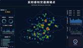
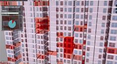
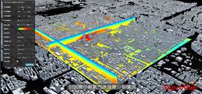
perception, Taxi track trajectory data and urban districts?? OD analysis, detection
of taxi dwelling areas (Figure 1). These cases help students understand the
differences between geo-big data and small data, the analytical paradigms and
methodologies of geo-big data, and the management and analysis of big data
using SuperMap software. This cultivates innovative talent aligned with market
demand.
2.4 Real Scene Modelling for the Frontiers of Science and Technology
With the development of new-generation information technologies such as
the Internet of
|
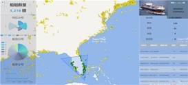
(a) Interface view of ship
flow data management and geofencing analysis
|
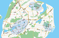
(b) Interface view of shared bicycle POI data and urban functional
area perception
|
|
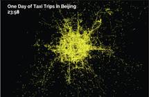 
(c) Interface view of taxi track trajectory data and urban districts?? OD
analysis
|
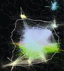
|
 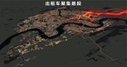
(d) Interface view of detection of taxi dwelling areas
|
Figure 1 Screenshots from experiments cases about
geographic big data
Things, big data, cloud computing, and
artificial intelligence, the implementation of digital twins has gradually
become possible[17]. Currently, many industries and organizations
are paying great attention to digital twins and have started to explore new
modes of intelligent applications based on digital twins, which is an effective
means to realize the interactive integration of the information world and the
real physical world[17]. Therefore, technologies and
applications such as ??smart cities??, ??digital twins?? and ??metaverse??
have great potential in the future.
To address the future science and technology, universities and
enterprises have jointly constructed experimental cases, such as real scene modeling of drone aerial images, BIM and sunshine analysis, and 3D
visualizations of city skylines and ozone Tetrahedralized Irregular Mesh (TIM), as depicted in Figure 2. These cases aimed to inspire students to understand and think
about the application and possible impacts of digital twins in the future
fields of urban planning, traffic planning, environmental safety and health; to
think about future changes in geographic research paradigms and methods; and to
inspire innovation thought.
3
Application of the Platform
To date, the platform has served the experimental teaching of 7
professional undergraduate courses in geography, such as Geographic Information
System, Principles and Practice of Spatial Databases, Analysis of
Spatio-temporal Big Data, and Comprehensive Internship in GIS, on the school??s
Beijing and Zhuhai campuses of BNU; at the same time, it also serves the
experimental teaching of the liberal studies course Spatio-temporal Big Data
and Social
|
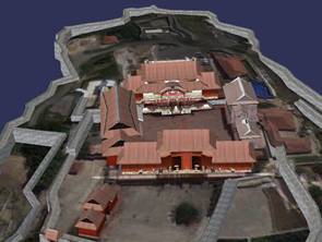
(a) Interface view of real scene modeling of
drone aerial images
|
|
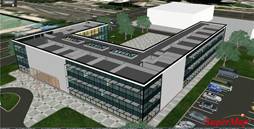 
(b) Interface view of BIM and sunshine analysis
|
|
(c) Interface view of 3D visualizations of city
skylines and ozone Tetrahedralized Irregular Mesh (TIM)
|
Figure 2 Screenshots from experiments cases about
real scene modelling
based on geographic big data
Perception and has cumulatively cultivated
several hundreds of undergraduates majoring in geography, economics and other
disciplines.
At present, the geographic big data management and analysis methods
taught by the platform can help students quickly extract OD matrices of 2,000
traffic intervals from GB-level Beijing taxi track data; it lays the
methodological and technological foundation for the practice of perceiving city
functions based on taxi tracks in the subsequent urban geography course,
realizes the linkage with the urban geography course and promotes the upgrading
of its teaching practices.
4
Conclusion
In the context of deepening the integration of
university-enterprise and promoting high-quality collaborative education, BNU
and SuperMap explored a new mode of university-enterprise actual input of human
and material resources for collaborative education based on the sharing
platform for geographic big data and real scenes modeling, which can serve as a reference for university-enterprise
collaborative education practices for other disciplines or universities.
Currently, the
platform serves BNU??s courses. Future plans include expanding its application
to other universities, enhancing collaborative education, and fostering
innovative talent in geographic information science nationwide.
Author Contributions
Cheng,
C. X. presided over the construction of the geographic big data experiment
platform. Shen, S., Du, K. P. and Zhao, W. Z. were responsible for carrying out
teaching practices on the experiment platform in conjunction with the
curriculum. Chi, L. X., Wang, L. and Xie, K. T. served as practical instructors
from SuperMap.
Conflicts of
Interest
The
authors declare no conflicts of interest.
References
[1]
Chen, Z. L., Wu, L., Wan, B.
Innovative practice in GIE student cultivation mode [J]. Journal of Geomatics, 2024, 49(2): 139?C142.
[2]
Li, H. F., Li, S. Reflections
on the educational reform of Geographic Information Science in the era of big data
and intelligence [J]. Journal of Higher
Education, 2017(21): 145?C146.
[3]
Cheng, C. X., Shi, P. J., Song,
C. Q., et al. Geographic big-data: a
new opportunity for geography complexity study [J]. Acta Geographica Sinica, 2018, 73(8): 1397?C1406.
[4]
Zhao, L., Deng, M., Xie, S. C.
Discussion on the training program for GIS professionals in the era of big data:
a case study of GIS professional in Central South University [J]. Geomatics & Spatial Information Technology, 2018, 41(10): 20?C23.
[5]
Jia, S. D., Zhang, L. H., Dong,
J., et al. Profession construction of
marine geographic information science in AI era [J]. Bulletin of Surveying and Mapping, 2023(S1): 5?C9.
[6]
Zhang, Z. H., Liu, L. M.
Construction and consideration of geographic information science professional
curriculum for universities with industrial features in the era of AI [J]. Bulletin of Surveying and Mapping,
2023(S1): 29?C33.
[7]
Deng,
M., Liu, Q. L. Exploration and practice on the cultivation of undergraduate
talents in Geographic Information Science in the era of ??big knowledge?? [J]. Bulletin of Surveying and Mapping,
2023(8): 178?C181.
[8]
Zhang,
X. C., Jian, G., Wang, M. Exploration and practice of Geographic Information
Science based on MOOCs and flipped classroom teaching model [J]. Journal of Spatio-temporal Information,
2021, 28(1): 12?C15.
[9] Zhang, S. L., Li, F. Y., Yang, X., et
al. Exploration and practice of the first-class curriculum construction of
??Principles of Geographic Information System?? [J]. Journal of Spatio-temporal Information, 2021, 28(1): 7?C11.
[10] Wu, H., Liu, P. C., Li, C., et
al. On the construction of Geographic Information Science under the
??Emerging Engineering?? strategy: from the perspective of new teaching methods
and teaching staff [J]. Education and
Teaching Forum, 2020(32): 119?C121.
[11] Yue, P. Development of high-performance geo-computation course [J]. Journal of Geomatics, 2019, 44(5):
100?C103.
[12] Shen, S., Cheng, C. X., Yang, C. Problems and countermeasures of the
curriculum system of spatial database [J]. Journal
of Spatio-temporal Information, 2022, 29(3): 26?C30.
[13] Zheng, G. Z., Gong, W. J., Zhang, Y., et al. Research on the mode of university-enterprise cooperation
for the practical ability training of Geographic Information Science [J]. Geomatics & Spatial Information Technology, 2021, 44(4): 16?C19.
[14] Hou, W. H., Liu, J. E. Discussion on the innovation direction of collaborative
education mechanisms in universities [J]. China
University Teaching, 2020(1): 42?C44.
[15] Wei, Q., Chen, S., Feng, S. B., et
al. Thoughts on the joint construction of Geographic Information System laboratories
by local applied universities and enterprises: a case study of the Geological
Engineering Major at Suzhou University [J]. Henan
Agriculture, 2022(21): 16?C17.
[16] Cheng, C. X., Pei, T., Liu, Y., et
al. The practice and method of natural disasters situational awareness in
the new era [J]. Acta Geographica Sinica,
2023, 78(3): 548?C557.
[17] Zhao, B., Cheng, D. F., He, D. D., et
al. White paper on digital twins applications 2020 [OL]. https: //
www.xdyanbao.com/doc/ktlshqdr4n?userid=57555079&bd_vid=904386881369663847.
2020,11.