Developing the Dataset of Shortest Railway Time from Beijing to 226
Cities in China (1996, 2003, 2009, 2016)
Wang, L. N.1
Li, X.2* Yu, X. K.2 Hu, T.2
1. College of Computer and Communication
Engineering, Zhengzhou University of Light Industry, Zhengzhou 450002, China;
2. Institute of Surveying and Mapping,
Information Engineering University, Zhengzhou 450052, China
Abstract: Beijing is one
of the most important railway transportation hubs in China. The shortest
railway travel times from Beijing to other Chinese cities throughout the years
offer an important basis for studying the changes in the spatial pattern of
Beijing??s accessibility to other Chinese cities and the development of and
changes in China??s national railways. In the present study, the data were
collected from the 1996, 2003, and 2009 China Railway Passenger Train
Timetables and the official website of the China Railway Service Center
(www.12306.cn). By sorting, calculating, and compiling these data, a dataset of
changes in the shortest railway travel times from Beijing to 226 Chinese cities
(1996, 2003, 2009, and 2016) was produced. Specifically, the dataset contains
the spatial coordinates of 226 Chinese cities, their spatial distances from
Beijing, their shortest railway travel times
from Beijing in 1996, 2003, 2009, and 2016, their time-space
conversion parameter values, and their deformed geographical coordinates.
The dataset is stored in .xlsx format, contains 908 records, and has a size of
187 KB.
Keywords: spatial distance; time distance;
shortest railway travel time; time space; time cartogram
Dataset Availability Statement:
The dataset supporting this paper was published and is accessible
through the Digital
Journal of Global Change Data Repository at:
https://doi.org/10.3974/geodb.2020.07.08.V1.
1 Introduction
From a conventional spatial
perspective, geographic locations are critical for understanding the spatial
relations of an object with other objects because the distance between any two
objects on the earth??s surface depends on their geographic locations. However,
as modern modes of transportation and communication undergo constant changes
and rapid development, basic concepts, such as space and distance, are being
understood and represented anew. Differing from scientism, which states that
space and distance are rigid and are the only unchangeable things, humanistic
geography maintains that humans perceive this world through the tools they
invent and make[1]. Time distance (TD) is gradually becoming an
important measure with which people perceive distances in this world. The focus
of people??s concern has shifted from ??how many kilometres are there between
Beijing and Zhengzhou??? to ??how long does it take to travel from Beijing to
Zhengzhou???. Thus, examining this world from a TD perspective is more congruous
with people??s present cognitive needs. In the geographic field, TD is often
used as an important metric to measure accessibility or economic relation
intensity and analyse regional transportation accessibility, urban spatial distribution
patterns, and social and economic processes[2?C3].
Differing from the invariant nature
of physical distance, TD is gradually changing with the continuous development
of transportation technology. In addition, the relation between geographic
space and time space, which is used to represent TD relations, is similarly undergoing
changes. During the primeval stage of human society, as a result of simple
means of transportation, geographic space, which was relatively homogeneous
(excluding the effects of natural and terrain factors), and time space remained
relatively similar to each another. However, the constant development of
transportation systems gradually disrupted the stable relationship between
geographic space and time space and increased their differences. On the one
hand, the development of transportation conditions overall increasingly shortened
absolute TDs and continuously ??shrunk?? the time space. On the other hand, the
imbalance in transportation development across regions leads to an increase in
their difference in relative TD. Changes in similarities or differences between
regions can be measured based on the spatial differences between temporal and
geographic maps.
As an
important political, cultural, economic, and international exchange centre and
the most important transportation hub, Beijing has a notable siphonic effect.
In particular, the continuous development of high-speed railways has
accelerated the flow and circulation of capital information and talents,
increased Beijing??s transportation accessibility, and strengthened its link
with other cities. The effects of these changes on time and space may be
exceedingly unbalanced. In this study, a dataset of changes in the shortest
railway travel times (SRTTs)
from Beijing to 226 cities in China (hereafter, the SRTT change (SRTTC)
dataset) (1996, 2003, 2009, and 2016) was developed. The SRTTC dataset offers
an important basis for examining the effects of railway transportation on the
changes in the spatial pattern of Beijing??s closeness and accessibility to
other cities and the development of and changes in China??s railways.
2 Metadata of the Dataset
The metadata summary of the ??Dataset of the shortest railway time from
Beijing to 226 cities in China (1996, 2003, 2009, 2016)??[4] is
listed in Table 1, including title, authors, geographic region, time, data files,
publishing and sharing service platform, and data sharing policy, etc.
3 Methods
3.1 Data Sources
The
original spatial coordinates of the 226 Chinese cities were based on the data extracted
from a 1: 4,000,000
vector map of administrative divisions of China and relevant geographic maps.
The SRTTs from Beijing to the other cities were calculated based on
authoritative data published by official railway agencies. The railway times in
2016 were determined by querying the official website of Railway Service Centre
of China[6]. The time data from 1996, 2003, and 2009 were manually calculated based on the
China Railway Passenger Train Timetables published by the China Railway
Publishing House in the respective years[7?C9].
Table 1 Metadata summary of the ??Dataset of changes in the shortest railway
travel times from Beijing to 226 cities (1996, 2003, 2009, and 2016)??
|
Item
|
Description
|
|
Dataset full name
|
Dataset of changes in the shortest railway travel
times from Beijing to 226 cities (1996, 2003, 2009, and 2016)
|
|
Dataset short name
|
TheShortestRailwayTimeBJto226CitiesChina
|
|
Authors
|
Wang, L. N., College of Computer and Communication
Engineering, Zhengzhou University of Light Industry, wln_map@126.com
Li, X., Institute of Surveying and Mapping,
Information Engineering University,
lixiangzzchxy@163.com
Yu, X. K., Institute of Surveying and Mapping,
Information Engineering University,
yuxinkai330521@163.com
Hu, T., Institute of Surveying and Mapping,
Information Engineering University, 1604599230@qq.com)
|
|
Geographic region
|
Rectangle enclosing 226 Chinese cities (18??14??02????N?C52??58??08????N,
75??59??09????E?C132??58??03????E)
|
|
Year
|
1996, 2003, 2009, 2016
|
|
Temporal resolution
|
1 Year
|
|
Spatial resolution
|
1:4,000,000
|
|
Data format
|
.xlsx Data
size 187 KB
|
|
Data files
|
Four worksheets corresponding to data from four years
(1996, 2003, 2009, and 2016)
|
|
Foundations
|
Zhengzhou University of Light Industry
(0131-13501050061); National Natural Science Foundation of China (41401467)
|
|
Data
publisher
|
Global Change Research Data Publishing &
Repository, http://www.geodoi.ac.cn
|
|
Address
|
No.
11A, Datun Road, Chaoyang District, Beijing 100101, China
|
|
Data sharing policy
|
Data from the Global Change
Research Data Publishing &Repository includes metadata, datasets (in the Digital Journal of Global Change Data Repository), and publications
(in the Journal of Global Change Data & Discovery). Data sharing
policy includes: (1) Data are openly available and can be free
downloaded via the Internet; (2) End users are encouraged to use Data subject
to citation; (3) Users, who are by definition also value-added service
providers, are welcome to redistribute Data subject to written
permission from the GCdataPR Editorial Office and the issuance of a Data
redistribution license; and (4) If Data are used to
compile new datasets, the ??ten per cent principal?? should be followed such
that Data records utilized should not surpass 10% of the new
dataset contents, while sources should be clearly noted in suitable places in
the new dataset[5]
|
|
Communication and searchable system
|
DOI, DCI, CSCD, WDS/ISC, GEOSS, China GEOSS,
Crossref
|
3.2 Technical Roadmap
Figure 1 shows the flowchart of the
dataset development.
3.2.1 City Selection Criteria
and Statistical Rules of SRTTs
The following describe
the criteria for selecting cities across China. (1) Railway travel time data
during the 1996?C2016 periods are available for all selected cities. (2) Prefecture-level
cities in each province are selected. (3) The selected cities basically cover entire
China and play a role similar to ??control points??. (4) As cities are sparsely
distributed in western China, some county-level cities in this region are added
as supplements. Based on these criteria, in total, 226 Chinese cities were
selected as control points. The longitude and latitude coordi nates of these
cities were determined based on the data extracted from a 1:4,000,000 vector
map of administrative divisions of China and relevant geographic maps.
To facilitate the determination and calculation of the
SRTT from Beijing to each city, the following rules were used. (1) The SRTT
from Beijing to each city selected for the statistical analysis was calculated
by summing the SRTTs in all railway sections without considering the number of
transfers and transfer wait times between urban stations. The following example
illustrates how the SRTTs are calculated: if the direct railway travel time
from Beijing
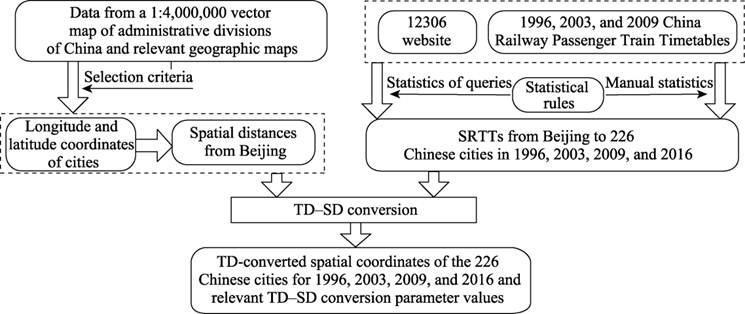
Figure 1 Flowchart of the dataset development
to city A is 230 min,
the SRTT from Beijing to city B is 80 min, and the travel time from city B to
city A is 120 min; then, the SRTT from Beijing to city A is determined by calculating
the sum total of the railway travel times from Beijing to city B and from city
B to city A, i.e., 80 + 120 = 200 min. (2) The spatial scale of this dataset
was set to national. Thus, an approach that ??uses a point to represent an area??
was applied to all cities. The distances between different stations in the same
city were not considered (e.g., both the Zhengzhou East Station and the
Zhengzhou Station were viewed as ??Zhengzhou??). (3) The time data for Hong Kong,
Macau, and Taipei were calculated based on those for Guangzhou, Zhuhai, and
Fuzhou, respectively, while considering the SD between the cities in each case.
3.2.2 TD?CSD conversion[10]
TD?CSD
conversion is a process that converts TD data to SD data, which are representable
on maps, and calculates new (i.e., TD-converted) coordinates for each point.
When producing the SRTTC dataset, the following three principles were adopted
during the TD?CSD conversion:
(1) The direction between each city point and
the central point (Beijing) remains unchanged after the conversion.
(2) For ease of calculation, the Euclidean distance
between two points is calculated as their SD.
(3) The total SD is constant, i.e., the sum
total of the SDs from the central point to all other points is constant, to
ensure ??scale consistency?? between the original map (based on SDs) and the
TD-converted temporal map (based on TDs) to facilitate the comparison and
analysis. The following describes the TD?CSD conversion:
Definition: Let 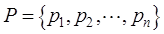 ,
, 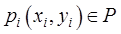 be a point
set,
be a point
set,  be the spatial coordinates of the central point O,
si be the SD from the central point O to point
be the spatial coordinates of the central point O,
si be the SD from the central point O to point  ,
,  be the railway travel time from the central point O to point ,
  be the sum total of the SDs from the central point O to all other points in point set
  , and
, and  be the sum total of the railway travel times from the
central point O to all other points in point set . Thus, we have
be the sum total of the railway travel times from the
central point O to all other points in point set . Thus, we have
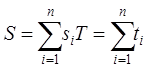 (1)
(1)
Let  (
( ) be the TD-converted SD from the central point O to point . As the total SD is constant,
  . is
calculated based on the proportion of to as shown
in Equation (2).
. is
calculated based on the proportion of to as shown
in Equation (2).
 ,
,  (2)
(2)
Then, based on the fact that the direction remains unchanged, the new (i.e.,
TD-converted) spatial coordinates of point  are
calculated as shown in Equations (3) and (4).
are
calculated as shown in Equations (3) and (4).
 (3)
(3)
 (4)
(4)
Here, a TD?CSD conversion
parameter r is introduced.  is the ratio of the TD-converted SD of a
certain control point to its original SD as shown in Equation
(5). The value of
is the ratio of the TD-converted SD of a
certain control point to its original SD as shown in Equation
(5). The value of  represents the extent to which point moves towards or away from the central
point along the direction betweenand the central point
after the conversion.
represents the extent to which point moves towards or away from the central
point along the direction betweenand the central point
after the conversion.
 (5)
(5)
(1) If  (i.e.,
  ), point moves
towards the central point after the conversion. A small value suggests that point moves
towards the central point to a large extent.
), point moves
towards the central point after the conversion. A small value suggests that point moves
towards the central point to a large extent.
(2) If  (i.e.,
  ), the coordinates of point remain
unchanged after the conversion.
), the coordinates of point remain
unchanged after the conversion.
(3) If  (i.e.,
  ), point moves away
from the central point after the conversion. A high value suggests that point moves away
from the central point to a large extent.
), point moves away
from the central point after the conversion. A high value suggests that point moves away
from the central point to a large extent.
Therefore, based on the
railway travel time data for the 226 cities in 1996, 2003, 2009, and 2016, the
TDs were converted to SDs. Thus, the TD-converted coordinates and r
values of the 226 cities were determined for each year. All calculations were
completed in Microsoft Excel. Thus, the SRTTC dataset was produced.
4 Data Results
4.1 Data Composition
The SRTTC dataset consists of one .xlsx file, which is composed
of four data sheets corresponding to data from four different years (1996,
2003, 2009, and 2016). The fields in the data sheets mainly include the
longitudes and latitudes of the 226 cities, their SDs from Beijing, their SRTTs
from Beijing, their TD-converted SDs, their r values, and their
TD-converted spatial coordinates.
4.2 Data Results
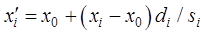
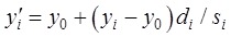
Figures 2?C5 visualize the changes shown in the SRTTC dataset in the spatial locations of the 226 Chinese
cities after the TD?CSD conversion in different years (1996, 2003, 2009, and
2016). Arrows are used to indicate the changes in the locations of the city
points after the conversion. The tail and head of each arrow correspond to the
original and TD-converted spatial coordinates of the cities, respectively. A
red arrow indicates that a city moves away from Beijing along the direction
between the city and Beijing. A blue arrow indicates that the city moves towards
Beijing along the direction between the city and Beijing.
Figure 2 Schematic diagram of the
changes in the spatial coordinates of 226 cities after the TD?CSD
conversion in 1996
Figure 3 Schematic diagram of the changes in the
spatial coordinates of 226 cities after the TD?CSD conversion in 2003
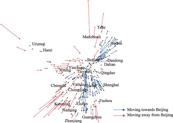
Figure 4 Schematic diagram of the changes in the
spatial coordinates of 226 Chinese cities after the TD?CSD conversion in 2009
|
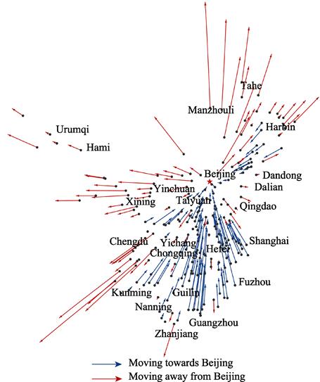
Figure 5 Schematic diagram of the changes in the spatial coordinates of 226 cities after the TD?CSD conversion in 2016
|
At a deep
level, whether a city moves away from or towards Beijing can reflect the city??s
transportation accessibility. A red arrow suggests that a city??s transportation
level is lower than the national average, whereas a blue arrow suggests that a
city??s transportation level is higher than the national average. Thus, as
demonstrated in Figures 2?C5, during the 1996?C2016 period, transportation
accessibility was predominantly lagging in most cities in northwestern and southwestern
China and a small number of cities in northeastern China. Notably, the arrows
of some cities in Fujian province shift from red to blue during the 2009?C2016
period. This finding indicates a change in the TD-converted locations of these
cities from moving away from Beijing to moving towards Beijing. This finding
further suggests railway construction and development in Fujian province and a
significant improvement in transportation accessibility between the cities in
Fujian province and Beijing during the 2009?C2016 period.
The length of each arrow indicates the extent of the
change in the location of the city and reflects the extent of the change in the
transportation accessibility of the city. The changes are shown in Figures 2?C5
demonstrate that during the 1996?C2016 period, most cities in southeastern China
remained advantageous in terms of transportation accessibility, and this
advantage gradually increased (as evidenced by the continuous increase in the
lengths of the blue arrows during the 1996?C2016 period). In addition, there was
a notable change in the transportation accessibility of the cities in
northeastern China. Overall, the transportation accessibility between most
cities in northeastern China and Beijing gradually improved during the
1996?C2009 period (as evidenced by the gradual increase in the lengths of the
blue arrows) but significantly decreased during the 2009?C2016 period (as
evidenced by the significant decrease in the proportion and lengths of the blue
arrows).
5 Discussion and Conclusion
The dataset of changes in the SRTTs
from Beijing to 226 cities in China was produced by method of data integration
for four temporal cross-sections (1996, 2003, 2009, and 2016). The dataset
facilitated explorations and investigations of the changes in the
transportation accessibility of cities across China at a national level, it
will help our understanding of the temporal-spatial patterns of the railway
transportation landscape. It is hoped that this dataset can provide a reference
and data basis for deeper investigations and analyses of patterns in relevant
fields, such as urban and economic geography and transportation.
Author Contributions
Wang, L. N.
formulated the overall design for the development of the SRTTC dataset. Wang,
L. N. and Li, X. collected and processed the data for the SRTTC
dataset. Wang, L. N. and Li, X. designed the model and algorithm. Yu, X. K.,
validated the data. Wang, L. N., Li, X., Yu, X. K., and Hu, T. prepared the manuscript.
References
[1]
Liu, X. T., Zhou, J. P. Transportation technology innovation and
time-space convergence: the case of the Hu-Ning Corridor [J]. Urban Development Studies, 2014,
21(8):56-60.
[2]
Jiang, H. B., Xu, J. G., Qi, Y. The
influence of Beijing-Shanghai high-speed railways on the land accessibility of
regional center cities [J]. Acta
Geographica Sinica, 2010, 65(10): 1287-1298.
[3] Jin, H. P.,
Zheng, L., Zhang, J. W. Network analysis of economic contact variability in the
Poyang Lake ecological economic zone based on travel time cost [J]. Economic Geography, 2013, 33(6): 148-154.
[4] Wang, L. N., Li
X., Yu, X. K., et al. Dataset of the
shortest railway time from Beijing to 226 cities in China (1996, 2003, 2009,
and 2016) [J/DB/OL]. Digtial Journal of Global
Change Data Repository, 2020. https://doi.org/10.3974/10.3974/geodb.2020.07.08.V1.
[5]
GCdataPR Editorial Office. GCdataPR
data sharing policy [OL]. https://doi.org/10.3974/10.3974/dp.policy.
2014.05 (Updated 2017).
[6] Railway Service
Centre of China. http://www.12306.cn.
[7] Transport Bureau
of the Ministry of Railways of China. China Railway Passenger Train Timetable
(1996 version) [M]. Beijing: China Railway Publishing House, 1996.
[8] Transport Bureau
of the Ministry of Railways of China. China Railway Passenger Train Timetable
(2003 version) [M]. Beijing: China Railway Publishing House, 2003.
[9] Transport Bureau
of the Ministry of Railways of China. China Railway Passenger Train Timetable
(2009 version) [M]. Beijing: China Railway Publishing House, 2009.
[10] Wang, L. N. Research on the
automatic construction method and application of cartogram [D]. Zhengzhou: Institute
of Surveying and Mapping, Information Engineering University, 2018.
[11] Wang, L. N., Li,
X., Jiang, N., et al. A new method of
constructing a central time-space map [J]. Acta
Geodaetica et Cartographica Sinica, 2018, (47)1: 123-132.