Development of Data Acquisition and Management System for
GEOSS Evaluation
Zhu, J.1,2 Liu, Y. H.3 Fan,
J. L.4* Liu, C.5 Wu,
J. J.6
Adugna, T.7
1. National Satellite
Meteorological Center (National Centre for Space Weather), Beijing 100081,
China;
2. Innovation Center for
FengYun Meteorological Satellite (FYSIC), Beijing 100081, China;
3. Aerospace Hongda Information
Technology Co., LTD., Beijing 100089, China;
4. Faculty of Geographical
Sciences, Beijing Normal University, Beijing 100875, China;
5. Institute of Geographic Sciences and Natural Resources
Research, Chinese Academy of Sciences, Beijing 100101, China;
6. Institute of Aerospace
Information Innovation, Chinese Academy of Sciences, Beijing 101408, China;
7. Yangtze Delta Region Institute (Huzhou), University of
Electronic Science and Technology of China, Huzhou 313001, China
Abstract: The Group on Earth
Observations (GEO) is an intergovernmental organization established in 2005
that aims to enhance our understanding of the Earth system and provide
information services for decision-making. The principal objective of the
organization is to develop a Global Earth Observation System of Systems (GEOSS)
to the benefit of mankind. The GEO work plan is the driving force in the implementation
of the GEO Strategy plan for the New Decade (2016?C2025). The progress of the
GEO work plan and the development of the Earth observation directly mark the
construction process of GEOSS. However, GEOSS is a complex multi-level,
multi-disciplinary, and multi-field integrated system. Obtaining information
about GEO work development and progress via traditional methods is extremely
challenging. For this reason, with the support of the Earth observation
satellite database operated by the WMO (World Meteorological Organization),
CEOS (Committee on Earth Observation Satellites), GEO library, GEOSS literature,
and related documents of Earth observation conferences, this paper presented
the GEOSS crowdsourced big data acquisition and management system integrated a
suite of crowdsourced big data acquisition technology. The system allows us to
obtain text messages, pictures, reports, audio and video, and scientific
articles related to Earth observation. In this paper, the system structure and
development was reported and the system may provide
effective support for the strategic evaluation of GEOSS progress.
Keywords: GEOSS;
big data; crowdsourced observation; GEOSS progress evaluation; GEO
DOI: https://doi.org/10.3974/geodp.2024.04.03
CSTR: https://cstr.escience.org.cn/CSTR:20146.14.2024.04.03
1 Introduction
The
Group on Earth Observations (GEO), an intergovernmental international
organization, was established in 2005[1,2] after three Earth
observation Ministerial Summits held in 2003, 2004 and 2005, respectively. The
organization was founded in response to an urgent request for coordinated
observations of the state of the earth at the 2002 World Summit on Sustainable Development in Johannesburg, South Africa, and the declaration of the
G8 Summit held in France in 2003, which stated that Earth observation should be
an important and priority action. With the mission to support informed
decisions through integrated, coordinated, and sustainable earth observations,
enhance understanding of the earth system, and provide information
services for decision-making. GEO primarily aims to develop a Global Earth Observation
System of Systems (GEOSS).
To achieve its
objective, the organization designed two strategic implementation plans for the
GEOSS spanning 20 years, from 2005 to 2025. The first 10-year strategic
implementation plan (2006?C2015) was formulated in the early days of GEO. The
project was a development
framework that identified 9 Societal Benefit Areas (SBA)[1]
such as disasters, health, energy, climate, water resources, weather,
ecosystems, agriculture and biodiversity. Following the conclusion of the first
plan, the second GEOSS strategic plan (2016?C2025) was launched at the fourth
GEO Ministerial Summit held in Mexico City in November 2015. This project
selected 8 SBAs to work in. These are biodiversity, ecosystem management,
disaster prevention and mitigation, energy and mineral resource management,
food security and sustainable agriculture, infrastructure, and transport system
management, public health monitoring, sustainable urban development, and water
resources management. Furthermore, GEO has identified the United Nations 2030
Agenda for Sustainable Development, the Paris Agreement on Climate Change, and
the Sendai Framework for Disaster Reduction as its top three working
priorities.
The GEO work plan
(2016?C2025) is an important working document to promote the implementation of the GEO new decade strategic plan[3]
where the GEO puts profound importance on executing the
GEO work plan and advancing the development of GEOSS. In this regard, many
Chinese scholars have played notable roles in contributing to the success of
the organization??s plan in several ways. Chinese researchers have constantly
been revising the international development trend[4?C8]
and carrying out follow-up research studies evaluating and commenting on GEOSS[9] data distribution system,
Asia and Oceania regional Earth observation system plan[10],
China??s use of foreign facilities[11]
to build Earth observation system, applications in the field of social benefit[12,13], and scientific data
sharing policies[14?C16].
However, GEOSS is a complex
multi-level, multi-disciplinary, and multi-field comprehensive system[17]. It
involves Earth observation systems in developed countries and developing countries[18?C20], hardware systems and software systems, and even regional,
language, human geography and other issues, both public welfare and commercial.
Consequently, it is extremely daunting task to obtain information on the
implementation and progress of GEOSS using the traditional approaches[21?C25].
This paper,
therefore, discusses some new ideas and techniques, especially the use of crowdsourced
big data technology to collect Earth observation
progress information to support GEOSS evaluation.
2 System Structure and Function
GEOSS
big data acquisition and management system focuses on the main idea of
??building environment, gathering data, developing applications, and providing
service support??, creating an application
evaluation system based on GEOSS application data, deeply mining the value of
data, and improving the evaluation ability of GEOSS application progress. The
system comprises 7 parts: infrastructure layer, data resource layer, application
service support
layer, business application layer, user interaction layer, security guarantee
system, and standard specification system. The overall framework and
topological structure of the system are shown in Figure 1 and Figure 2,
respectively. The infrastructure layer includes network and basic hardware,
which is used to support the stable operation of various application systems.
The network environment of the system mainly relies on cloud servers. Basic
hardware includes servers, network and storage devices, and others.
As an information
resource center, the data resource layer provides comprehensive data services
to ensure system operation. Data is stored in a structured and distributed
manner. The stored data includes spatial database data, information materials,
conference information, interview materials, and other relevant materials.
The application
service support layer includes, data engine, workflow engine, interface
service, model base construction technology, web crawler technology, and so on.
Under the support
of the security system, the business application layer carries out business
applications on the basis of infrastructure, database, shared components, and
data center, including data management, evaluation model management, and GEOSS
application progress evaluation.
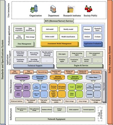
Figure 1 The overall framework
of the system
The user
interaction layer is the interface between the system and users, where users
can process, generate, and obtain the required information.
The security
guarantee system is the legal basis and institutional guarantee for the normal
operation of the system, including laws, regulations and standards, as well as
information security, system security organization and management system.
The standard and
specification system comprised of the unified national standards and
specifications, the technical specifications adopted, and the unified format of
data that are followed and implemented during system development and
application.
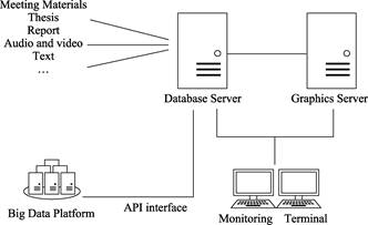
Figure 2 The topological
structure of the system
The function of
GEOSS big data acquisition and management system is to integrate CEOS/ESA MIM
spatial database, WMO OSCAR (Observing Systems Capability Analysis and Review
Tool) spatial database, GEO Library and crowdsourced big data by information technology to obtain the information and
materials related to GEOSS. The information includes text messages, pictures,
reports, audio and video, scientific paper data. All the information was
acquired and managed by the Earth Observation Big Data Platform.
3 System Design
GEOSS
big data acquisition and management system adopts a component-based design idea
and B/S structure based on the general web browser specifications. It is
compatible with Google browser and 360 browser by
default. The system provides functional modules for sustainable loading and
maintenance services and can continuously improve and expand system functions.
The data of the
GEOSS big data acquisition and management system mainly includes CEOS/ESA MIM
spatial database, WMO OSCAR spatial database, GEO library information
materials, earth observing-related text messages, pictures, reports, audio and
video, scientific paper materials. These data can be obtained from various
sources including GEO work plan symposia, GEO plenary and Earth Observation
Ministerial Summits, AOGEO, EUROGEO, AmeriGEO, AfriGEO, CEOS, the China-Europe
Dragon Program, SPIE Earth Observation satellite session, IGARSS Earth
Observation satellite session and other Earth observation conference. For data
storage, MySQL database is used to store structured data, whereas, HBase
database is employed for unstructured data.
3.1 Data Architecture Design
The
data storage function is the core and foundation of the platform to provide
external services. In the development of software systems, data storage design
should follow the necessary design principles and theories so as to reduce data
redundancy and ensure the integrity and correctness of data. The design scheme
is directly related to the efficiency of system execution and the stability of
the system. In order to construct a solid, reliable, and high-performance
information service system, the data storage design follows the following basic
principles:
(1) The principle of centrality
The system realized system centralized, data
centralized, processing centralized under the unified design, and following the
unified standards in the development and application.
(2) The principle of advanced and mature
The system chooses a certain advanced
representative level and relatively mature technology to build an information
service system by adopting the latest and most common hardware platform and
database engine. In addition, it manages the data specification and authority
of the system through the management and maintenance of the database, ensures
the stability and maturity of the system, and maintains a certain advancement.
(3) Reliability and availability principle
The system fully considers the capacity of
strain, fault tolerance, and error correction, and adopts highly reliable
technology for development to ensure the stable operation and reliable safety
of the system.
(4) The principle of benefit and
practicability
The design and development of this system
comprehensively consider the economic and social benefits of the system.
(5) The principle of prospectivity and
expansibility
The system design possesses innovative
features to ensure that the system is still advanced and stable in a long
period of time. Additionally, the system has good expandability and
upgradeability, which allow seamless upgrades to a new generation of equipment
and technology platform.
(6) The principle of security and
confidentiality
The security and confidentiality of the
system focuses on the design and development of equipment security, network
security, and data security from multiple angles to ensure the security of
business information.
(7) Standard and normative principles
The database construction of the system
adheres to the relevant national standards and norms, in which data
stratification, classification and coding, accuracy, symbols and other
references to the existing relevant national standards were considered.
(8) Overall accuracy principle
The database content design of this system is
as comprehensive as possible to ensure that the type and length of the fields
in the database can meet the needs of business applications at the current as
well as in the future.
(9) Principle of loose coupling
Each subsystem
of the system follows the principle of loose coupling, that is, no mandatory
constraint relationship is set between each subsystem. The connection between
subsystems is established by re-input, query, program default filling, and so
on. And, the associated fields between subsystems are redundant storage.
The database
stores text messages, pictures, reports, audio and video, and other data by
accessing other business data platform through data interface. The
preprocessing includes data decoding, data combination, and rearrangement,
format conversion, and so on.
The various
types of data were accessed from different websites, as shown in Table 1, and
the list of data along with the associated data sources, types, and database is
illustrated in Table 2.
Table 1
List of
data sources
|
Data sources
|
Get URL
|
|
CEOS/ESA MIM
Spatial Database
|
http://database.eohandbook.com/
|
|
WMO OSCAR
Spatial Database
|
https://space.oscar.wmo.int/
|
|
GEO Library
|
https://earthobservations.org/resources
|
|
Work plan Workshop
|
https://earthobservations.org/events
|
|
GEO Plenums and Summits
|
https://www.earthobservations.org/
|
|
AOGEO
|
https://aogeo.net/
|
|
EUROGEO
|
https://www.eurogeosec.eu/
|
|
AmeriGEO
|
https://www.amerigeo.org/
|
|
AfriGEO
|
https://earthobservations.org/organization/work-pro
gramme/african-group-on-earth-observations
|
|
CEOS
|
https://www.ceos.org/
|
|
China-Europe
Dragon Program
|
https://dragon5.esa.int/
|
|
SPIE Earth
Observation Satellite Special
|
https://spie.org
|
|
IGARSS Earth
Observation Satellite Special
|
https://www.grss-ieee.org/
|
Table 2 List of data sources and data types
|
Num
|
Data name
|
Data source
|
Data type
|
Database
|
|
1
|
Information
about the GEO
|
CEOS/ESA MIM, WMO OSCAR
|
.xml, .json,
.csv, .nc, .html, .pdf
|
Local disk,
MySQL
|
|
2
|
GEO related information
data
|
Crowdsourced data
|
.txt, .jpg, .png, .pdf,
.docx, .mp3, .mp4, etc.
|
Local disk,
HBase
|
|
3
|
Scientific paper
|
Crowdsourced data
|
.docx, .pdf
|
Local disk,
HBase
|
|
4
|
Conference
materials
|
GEO workplan symposia, GEO Plenary and Summit,
AOGEO, EUROGEO, AmeriGEO, AfriGEO, CEOS, China-Europe Dragon Program, SPIE,
IGARSS, other Earth observation conference
|
.docx, .jpg, .pdf
|
Local disk,
HBase
|
3.2 Interface Design
The
interface design generally follows the design principle of high cohesion and
low coupling, which is also an important principle to
implement in the process of software design. The procedure helps to reduce the
coupling degree between the systems and the modules within the system. In
addition, it lessens the complexity of the operation, ensures the universality
of the system, improves the system reusability and scalability.
The specific
principles are as follows:
(1) Main
principles
1) All the
interface design follows the project construction regulations and interface specifications;
2) Consider the
component-based design idea of SOA to achieve loose coupling between systems.
(2) Other
principles
1) Easy to use,
fast, versatility, high reliability;
2) Full
consideration of the application expansion for the various system interfaces,
and flexibly support of the changing demands;
3) The
consistency of the interface data among various systems;
4) The confirmed
process after the transmission and the reception in the process of data
interaction.
Interface
implementation methods include messages, API, and shared directories.
In this system,
the message queue mode is mainly used for the transmission of monitoring
information between the monitoring system, and the transmission of job
scheduling instructions between each system. Its design incorporates several
functions such as message encapsulation,
automatic routing, reliable message conversion and message transmission. It
also has the function of encryption and fault tolerance for special messages.
In order to
maintain the compatibility of interfaces between multiple systems, it is necessary
to provide a variety of API for other subsystems to obtain data from the main
system. The API interface design has the following attributes: independent
package of logical processing function interface, convenient integration with
front-end C, JAVA, PYTHON, and other programs, API management function, high
reliability and efficiency of connection with the server, and complete logging
function. Besides, it has the function of configurable connection parameters
with the server.
The shared
directory is employed to exchange file data within the system. The shared directory
interface is designed as follows: interactive file storage directories in a
unified manner, efficient and reliable directory management strategy, configurable
directory of read and write permissions control, reliable trigger mechanism for
data file arrival and processing, identification of completed or incomplete
status for data file copy, identification of being processed or unprocessed
status for data file.
The shared
directory interface mainly realizes the interaction of data files between systems
by means of shared read-write storage. When files are read or written, it is
realized through the copy mechanism of directory files.
3.3 Performance and Non-functional Design
3.3.1 Performance Optimization Design
The
performance of this system is mainly reflected in timeliness, stability, easy
operation, and scalability. In order to ensure the realization of performance
indicators, it is necessary to optimize the design of database servers,
database access, application programs, and others.
3.3.2 Optimization Design of Database Server
Data
Block: the data file of the database is stored in blocks of appropriate size to
obtain the best data storage space and efficient access.
Parallel
Processing: Data query and insert, modify, delete and other operations make
full use of the parallel processing capability of the database.
Raw Device: the
raw device is used as the data storage medium (database) to improve the
performance of the database with frequent read or write operations.
3.3.3 Database Optimization Design
Sub-database:
Based on the distributed database principle, the sub-database design ensures
that the data is evenly distributed on each underlying database instance, and
can be efficiently queried and accessed.
Field Index: In
considering the requirements of data storage and application, the appropriate
data field index is designed.
3.3.4 Application Optimization Design
Cache:
Parameter tables or metadata repeatedly used are cached in the memory to improve
data application efficiency.
Paging: The
system query results are displayed in a reasonable paging mode to avoid large
result sets, and effectively improve the system response speed and performance.
Parallel
processing: It makes full use of the computing power of multi-core CPU by the
parallel processing of dense data to improve the efficiency of system
operation.
3.3.5 Reliability Design
In
order to ensure the reliable and stable operation of the system, the following
strategies are adopted in the design scheme.
(1) High
availability policy: Adopt the high availability policy, the system services
are deployed on the primary and secondary servers. The primary and secondary
services detect the system availability through heartbeat monitoring, and find
the system crash phenomenon in time, so as to ensure that the whole system can
still run normally without crash or data loss in case that a server fails.
(2) High
efficiency strategy: With the continuous richness of data acquisition, the requirements
for system service capability, data access capability (IO capability), and computing
power will become higher and higher. Therefore, the use of the current more advanced
big data technology, such as distributed database architecture, parallel
computing, parallel scheduling, distributed computing, efficient shared file
storage, and other technical means, ensure that the system runs efficiently
under the pressure of large data volume processing.
(3) Software
complexity control: The system has many modules and complex logic, in order to
reduce the sensitivity of software defects to the input environment and
decrease the probability of software failures. The object-oriented design
method is adopted in software design, and the length and logic complexity of
the program is controlled. Consequently, the software has the characteristics
of encapsulation, abstraction, and inheritance, the object is relatively
independent, and the internal elements of the object are closely related, thus
forming a ??high cohesion, low coupling?? software system.
The error rate estimate
range of the program is generally 0.04%?C7%, for less than 100 statements of the
program. The number of lines of the source code and the error rate are linearly related. The error rate increases in a non-linear way with the
increase of the program statements. In this software package, the length of
code for the method design in the object is controlled to an average of about
60 lines.
The complexity
of the program flow is controlled. The system analyzes the number of program
branches and the number of cycles. If the complexity is more than 10 programs,
it decomposes into smaller programs to reduce the program error rate.
(4) Error
correction mechanism: This system sets the system running log to record the key
steps and abnormal information in the system operation. The system running log
with its extension of ??.log?? is a collection of log records arranged in
chronological order, in the form of a text file composed of lines of text. Once
a system failure occurs, such as a system crash, one can query the system
running log to find out the exact reason for the system failure. In the design
of the decision scheme evaluation and optimization subsystem, JAVA exception
handling mechanism is applied to all kinds of system running exceptions, such
as null pointer errors.
3.4 Design of Data Acquisition Subsystem
Data
acquisition subsystem has GEO application data collection, processing,
classification, archiving, warehousing and other functions. The data
acquisition and entry subsystem is composed of automatic data acquisition
module, data entry module and data archiving module.
According to the
data type listed in Table 2, the automatic data acquisition module realizes the
collection of various types of business data required by the project.
The data entry
module realizes the manual entry of relevant data, and stores the data in the
database after the data verification.
(1) The
collected data will be scientifically classified, and the data entry
verification standard will be set and recorded by the data collector.
(2) For text
data, the file is saved in .docx format after manual input.
(3) For table
data, saved in .xlsx format in order to query and
analysis.
(4) For photos
or multimedia data, saved separately in .jpg format or general streaming media
format.
The data
archiving module is meticulously designed to achieve categorized data and
search through metadata, intermediate data, business data, mining data, and
other data, and to improve the accuracy and efficiency of the user retrieval,
invocation, and mining of the data. As a result, users can automatically
classify the data by presetting classification rules, or manually define new
classification rules to categorize the data. Finally, the comprehensive
interface of the system is developed as the Figure 3.
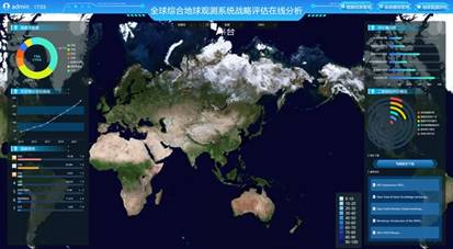
Figure
3 System interface
4 Conclusion
The
GEOSS is a complex multi-layered, multi-disciplinary, and multi-field
integrated system. What progress has GEOSS made in its second decade of
development, and how can it be objectively assessed? These are the critical
questions of the whole earth observation community. Based on the documents of
relevant Earth observation conferences, the authors used crowdsourced data
acquisition technology to retrieve information related to GEOSS development
progress, including text message, picture, report, audio and video information,
and scientific paper. After evaluating the existing systems, an advanced GEOSS
big data acquisition and management system was developed to play a unique
supporting role for the evaluation of GEOSS??s strategic progress.
Author Contributions
Fan,
J. L. and Liu, Y. H. made the overall design of the system; Zhu, J., Liu, C.
and Wu, J. J. put forward optimization suggestions for the system design; Fan,
J. L., Zhu, J. and Adugna, T. wrote the paper.
Conflicts of Interest
The authors declare no conflicts of interest.
References
[1]
Feng, J., Gao, F., Huang, X. Y.
Constructing an integrated global Earth observation system: three international
Earth observation summits and GEOSS [J]. Advances
in Earth Science, 2005, 20(12): 7. DOI:
10.3321/j.issn:1001-8166.2005.12.008.
[2]
Xiao, Y. The world will
strengthen cooperation in Earth observation [J]. Space International,
2005(4): 1. DOI: CNKI:SUN:GJTK.0.2005-04- 003.
[3]
Fan, J. L., Liu, C., Wu, J. J., et al. Analysis on the characteristics
of the eighth phase plan (2023?C2025) of the Group on Earth
Observation (GEO) [J]. Journal of Global
Change Data & Discovery, 2023,7(3): 233‒241. https://doi.org/10.3974/geodp.2023.03.01.
https://cstr.escience.org.cn/CSTR:20146.14.2023.03.01.
[4]
Li, M. X. Earth observation
decade execution plan and enlightenment [J]. Science & Technology Industry of China, 2007(7): 4. DOI: 10.3969/j.issn.1002-0608.2007.07.018.
[5]
Li, M. X., Zhang, S. M. Earth
observation field international science and technology cooperation status,trends and enlightenment [J]. Remote
Sensing Information, 2009(2): 4. DOI: 10.3969/j.issn.1000-3177.2009.02.022.
[6]
Zhang, D. F. The global Earth
observation system of portal [D]. Beijing: Beijing Forestry University, 2016.
DOI: CNKI:CDMD:2.1016.145077.
[7]
Zhao, L. M., Miao, C., Xing, J.
et al. Earth observation knowledge
hub: connotation, key technology and prospect [J]. National Remote Sensing Bulletin, 2024, 28(6): 1375?C1394. DOI:
10.11834/jrs.20222302.
[8]
Li, G. Q, Zhang, H. Y, Zhang,
L. C., et al. Tendency of the
development of Earth observation data sharing [J]. National Remote Sensing Bulletin, 2016, 20(5): 12. DOI: 10.11834/jrs.20166173.
[9]
Fan, J. L. Earth observation
satellite data distribution system development review [J]. Advances in Earth Science, 2012, 27(7): 712‒716. DOI:
10.13769/j.cnki.cn50-1011/d.2014.07.024.
[10] Gu, X. F., Niu, Z., Yu, T. et
al. Asia Pacific regional integrated Earth observation system plan progress
[J]. National Remote Sensing Bulletin,
2018, 22(4):14. DOI: 10.11834/JRS.20188065.
[11] Liu, C., Wen, H. T., Zhao, L. C.
et al. EOS MODIS in our country present situation, problems and countermeasures
of construction of ground station [J]. Remote
Sensing Information, 2003(4): 42‒47. DOI: 10.3969/j.issn.1000-3177.2003.04.011.
[12] Fan, J. L., Zhang, M. W., Cao, G. Z., et al. Global satellite monitoring drought plan [J]. Advances in Meteorological Science and
Technology, 2014, 4(5): 4. DOI: 10.3969/j.issn.2095-1973.2014.05.006.
[13] Li, S. J. International cooperation mechanism for space disaster reduction
(IV) introduction of Group on Earth Observations (GEO) mechanism [J]. Disaster Reduction in China, 2018, 330(15):
52?C53. DOI: CNKI: SUN:ZGJI.0.2018-15-018.
[14] Sun, S., Zhang, X. E., Guo, Z. Y. et al. The scientific data sharing policy report [J]. China Basic Science, 2002(5): 3. DOI:
10.3969/j.issn.1009-2412.2002.05.009.
[15] Jing, G, F. Open science to analysis the influence of the global
integrated construction of Earth observation system [J]. Remote Sensing for Land and Resources, 2020, 32(4): 7. DOI:
10.6046/gtzyyg.2020.04.01.
[16] Chu, W. B., Uhlir, P. F. Summary of symposium on data sharing, data management
solutions and best cases in Group on Earth Observations
(GEO) [J]. Journal of Global Change Data & Discovery, 2017, 1(4): 486?C489.
https://doi.org/10.3974/geodp.2017.04.21.
[17] Ma, C. L., Gao, Y. B. System integration of the global Earth
observation system and the global ocean observation
system [J]. Ocean Technology,
2006(3): 41?C44+50. DOI: 10.3969/j.issn.1003-2029.2006.03.010.
[18] Yang, F. The European Union to strengthen the construction of
ability of Earth observation [J]. Chinese
Journal of Space Science, 2018, 38(1): 1. DOI: CNKI:SUN:KJKB.0.2018-01-009.
[19] Li, M. X., Townshend, J. R., Wu, B. F. China??s contribution to the global
Earth observation system [J]. National Remote
Sensing Bulletin, 2010(3): 8. DOI:10.3724/SP.J.1011.2010.01138.
[20] Miao, C., Liu, Z. C., Zhang, J., et
al. The composition and practice of China??s integrated Earth Observation
System [J]. Remote Sensing Information,
2024, 39(2):12‒18.
[21] Sun, K., Chen, Y. W., Li, J. F., et
al. Earth observation satellite system performance evaluation index system
research [C]. The harmonious development and systems engineering, systems
engineering society of China the 15th annual conference proceedings, 2008. DOI:
ConferenceArticle/5aa0852fc095d722207612c6.
[22] Sun, K., Chen, Y. W., Li, J. F., et al. Earth observation satellite system performance index and its
application simulation study [J]. Computer
Simulation, 2009(4): 4. DOI: 10.3969/j.issn.1006-9348.2009.04.015.
[23] Xiang, L., Meng, X., Zhang, X. C., et al. Earth observation satellite system effectiveness evaluation
based on HLA study [J]. Computer Simulation, 2010(7): 5. DOI:
10.3969/j.issn.1006-9348.2010.07.008.
[24] He, D. L., Li, G. P., Hou, Y. K. Space-based Earth observation
system effectiveness evaluation study [J]. Chinese
Space Science and Technology, 2014, 34(1): 8. DOI: 10.3780/j.issn.1000-758X.2014.01.003.
[25] Sun, W. W., Yang, G., Chen, C., et
al. China??s current situation of the development of Earth observation satellite
remote sensing and literature analysis [J]. National
Remote Sensing Bulletin, 2020, 24(5): 32. DOI: CNKI:SUN:YGXB.0.2020-05-001.