Spatial Distributions of Lakes across the Eight Largest
Deserts of China (2000?C2019)
Feng, Q. Y.1,2 Liu, K.1* Fan, C. Y. 1,3 Song, C. Q.1
1. Nanjing Institute of Geography and Limnology, Chinese
Academy of Sciences, Nanjing 210008, China;
2. School of Remote Sensing and Geomatics Engineering,
Nanjing University of Information Science and Technology, Nanjing 210044, China;
3. University of Chinese Academy of Sciences, Beijing
100049, China
Abstract: Desert lakes are an
essential link in maintaining the biodiversity and ecosystem stability in
desert areas. A timely and accurate understanding of their temporal and spatial
characteristics is significant for revealing the regional water cycle and
ecological environmental changes. This study is based on the global surface
water datasets (JRC GSW and GLAD). The research objects are China??s eight
deserts (Taklimakan, Gurbantungut, Kumtagh, Chaidamu, Badain Jaran, Tengger,
Ulan Buh, and Hobg Deserts), which are combined with manual interpretation and
quality control to form a dataset of the spatial and temporal distribution of
lakes in China??s eight significant deserts from 2000 to 2019. The spatial data
include: (1) the maxextent water body distribution data of lakes in China??s
eight deserts during the year (.shp); (2) the permanent water body distribution
data of lakes in China??s eight deserts
during the year (.shp). The table data include: (1) number and area of maxextent
water bodies in desert lakes of China from 2000 to 2019; (2) number and area of
permanent water bodies in desert
lakes of China from 2000 to 2019. The dataset is stored in shapefile format, 38
groups of files, and the data volume is 32.3 MB (compressed into one file, 13.4
MB).
Keywords: China desert; lakes; spatial-temporal distribution;
area change
DOI: https://doi.org/10.3974/geodp.2022.01.06
CSTR: https://cstr.escience.org.cn/CSTR:20146.14.2022.01.06
Dataset Availability Statement:
The dataset supporting
this paper was published and is accessible through the Digital Journal of Global Change Data Repository at:
https://doi.org/10.3974/geodb.2021.09.05.V1 or
https://cstr.escience.org.cn/CSTR:20146.11.2021.09.05.V1.
1 Introduction
China
is one of the most widely distributed deserts countries in the word, with the
majority located in the arid and semi-arid climate areas of the northwest[1].
Although the desert is associated with significant climatic dryness,
droughtlow-lying areas within the desert also form small lakes[2]
due to local surface runoff and groundwater recharge. These lakes accumulate
precious water sources in desert areas and play an important role in
maintaining regional biodiversity and ecosystem stability. Meanwhile, these
desert lakes are prone to climate change and have significant fluctuations in
the inter year and within the years. At present, some studies have conducted
remote sensing surveys on the change characteristics of desert lakes in China[2,4?C6].
However, these studies mainly focus on the lakes in the Badanjaran and Tengger
Deserts and lack the dynamic changes of desert lakes at the national scale.
Remote sensing
technology and data are needed to study the dynamic lake changes at a large
regional scale, especially in desert areas with the harsh natural environment.
In recent years, there are has been an increase in the number of remote sensing
data products that can be used to monitor lake dynamic changes, ranging from
Landsat, Sentinel-2, and other optical images to a variety of publicly released
global lake, reservoir, and water data products[7], all of which
allow for the exploration of surface water changes in large regions and long
time series. In this study, eight major deserts in China were selected as
research areas, and JRC GSW, and GLAD water data products were extensively used[8,9]
to construct a dataset of lake spatial and temporal distribution in eight major
deserts in China from 2000 to 2019. The data reveal the overall change trend
and spatial and temporal patterns of desert lakes in China in the past 20 years
and will provide basic data for desert hydrology, ecology, and climate
research.
2 Metadata of the Dataset
The
metadata of the Dataset of temporal-spatial
distribution of lakes in the eight deserts of China (2000?C2019) dataset
is summarized in Table 1. It includes the dataset??s full name, short name, authors,
year of the dataset, temporal resolution, spatial resolution, data format, data
size, data files, data publisher, and data sharing policy, etc.
3 Methods
The processing process of
this study is shown in Figure 1, and it mainly consists of four steps. First,
the scope of this study area was determined by referring to the vector range of
the eight deserts in China provided by the dataset[12] of the
1:100,000 distribution atlas of deserts in China. Second, the global surface
water dataset of JRC GSW[1] was downloaded according to
the desert area, and it provides water data with different definitions. In this
study, the layer of annual maximum water area and annual permanent water layer
were mainly selected. The GLAD Global Water Dataset[2]
produced by the global land analysis and discovery research team at the
University of Maryland was used as a supplement to the problem of missing data
in some years and regions of JRC GSW data. Given that GSW and GLAD data
represent all surface water information, the other natural water bodies, such
as reservoirs and rivers, need to be removed in the third step. Lakes in desert
areas are mostly shallow lakes, wherein division and merger of lakes more
frequently occur[2]. Based on the determination of lake
water area, the attributes of water patches adjacent to space must be further
merged. Finally, the water boundary is manually checked to eliminate the tiny
voids and excellent boundaries in the water in combination with the historical
image data. In addition, we have marked the lake area[3] and desert
area for each lake. The lakes in China
Table
1 Metadata summary of the Dataset of temporal-spatial distribution of
lakes in the eight deserts of China (2000?C2019)
|
Items
|
Description
|
|
Dataset full name
|
Dataset of temporal-spatial
distribution of lakes in the eight deserts of China (2000‒2019)
|
|
Dataset short name
|
DesertLakes_2000-2019
|
|
Authors
|
Feng, Q., Y., Nanjing
Institute of Geography and Lakes, Chinese Academy of Sciences, School of
Remote Sensing and Surveying and Mapping Engineering, Nanjing University of
Information Engineering, 201813350012@nuist.edu.cn
Liu, K.,
Nanjing Institute of Geography and Lakes, Chinese Academy of Sciences,
kliu@niglas.ac.cn
Fan, C. Y., Nanjing
Institute of Geography and Lakes, Chinese Academy of Sciences,
fanchenyu_1996@163.com
Song, C. Q., Nanjing
Institute of Geography and Lakes, Chinese Academy of Sciences,
cqsong@niglas.ac.cn
|
|
Geographical region
|
Eight deserts of China
|
|
Year
|
2000‒2019
|
|
Temporal resolution
|
Inter-annual
|
|
Spatial resolution
|
30 m
|
|
Data format
|
.shp
|
|
|
|
Data size
|
13.4 MB (compression)
|
|
|
|
Data files
|
Spatial data: (1) Maximum
water distribution data of lakes in eight deserts in China from 2000 to 2019;
(2) Annual permanent water distribution data in eight deserts in China from
2000?C2019
Table data: (1) Statistics
of maximum water quantity and area of lakes in eight deserts in China during
2000?C2019; (2) Statistics of permanent water quantity and area of lakes in
eight deserts in China from 2000 to 2019
|
|
Foundations
|
Ministry of Science and
Technology of P. R. China (2019YFA0607101); Chinese Academy of Sciences
(XDA23100102)
|
|
Data publisher
|
Global
Change Research Data Publishing & Repository, http://www.geodoi.ac.cn
|
|
Address
|
No. 11A, Datun Road,
Chaoyang District, Beijing 100101, China
|
|
Data sharing policy
|
Data
from the Global Change Research Data Publishing & Repository includes metadata,
datasets (in the Digital Journal of Global Change Data Repository),
and publications (in the Journal of Global Change Data & Discovery). Data sharing
policy includes: (1) Data are openly available and can
be free downloaded via the Internet; (2) End users are encouraged to use Data
subject to citation; (3) Users, who are by definition also value-added
service providers, are welcome to redistribute Data subject to written
permission from the GCdataPR Editorial Office and the issuance of a Data
redistribution license; and (4) If Data are used to compile new
datasets, the ??ten per cent principal?? should be followed such that Data
records utilized should not surpass 10% of the new dataset contents, while
sources should be clearly noted in suitable places in the new dataset[7]
|
|
Communication
and searchable system
|
DOI, CSTR, Crossref, DCI, CSCD, CNKI,
SciEngine, WDS/ISC, GEOSS
|
can
be divided into five major lakes according to the distribution, origin, water
environment, resource occurrence, and hydrological characteristics of lakes,
combined with the geomorphic characteristics of high west and low east of China
and the climatic conditions of wet south and dry north and considering the
statistical convenience of administrative division of China. This dataset
involves two lake areas: the Qinghai?CTibet Plateau lake area (including Qinghai
and Tibet) and the Meng?CXin lake area (including Inner Mongolia, Xinjiang,
Gansu, Ningxia, Shaanxi, and Shanxi). Some differences can be observed between
the boundary of the Qinghai?CTibet Plateau lake area and the natural boundary of
the Qinghai?CTibet Plateau. The scope of the Meng?CXin lake area includes the
Loess Plateau[3]. Finally, the annual dataset of lake distribution
in eight desert regions of China from 2000 to 2019 was formed (>0.1 km2).
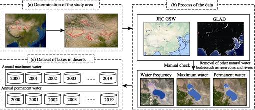
Figure 1 Processing process of the dataset
development
4 Data Results
4.1 Data Composition
The
spatial and temporal distribution dataset of lakes in the eight deserts of
China (2000?C 2019) provides year-by-year spatial distribution data of lakes in
the eight deserts of China during the study period. Considering that desert
lakes have significant annual fluctuations, this dataset contains two sets of
lake water products, including annual permanent water distribution data and
annual maximum waterbody data. These data are stored in shapefile format. The
dataset also provides the statistical results of the maximum water quantity and
area of desert lakes in China from 2000 to 2019. Moreover, the statistical
results of the permanent water quantity and area of desert lakes in China from
2000 to 2019 are also illustrated in the tables.
4.2 Data Products
4.2.1 Interannual Variation of Desert
Lakes
The
lakes in the eight deserts of China have significantly varied from 2000 to
2019. The total number and area of desert lakes have also significantly
increased. In 2000, the total number of desert lakes was 219 with a total area
of 1,502.62 km². In 2019, the number of desert lakes were increased by 98
compared with 2000, which is an increment of 44.75%. Meanwhile, the respective
lake areas were also increased by 258.64 km2, accounting for 17.21%.
However, the interannual variation of lakes in the eight deserts has shown
certain fluctuation characteristics, as shown in Figure 2. For instance, the
lake area values were relatively low in 2001, 2009, and 2015 and exhibited
obvious peaks in 2003, 2011, and 2018. An evident decline trend was observed
from 2011 to 2015. Accordingly, the total area of the lake was decreased by
38.70% from 2,088.11 km2 in 2011 to 1,280.11 km2 in 2015.
The increment in
the total area of the lakes from 2009 to 2010 is attributed to the rapid
increase of Lake Taijiner in the east (west). By contrast, the sudden increase
in the total area of desert lakes in 2015?C2016 was mainly led by the
significant increase in the area of Ebi Lake (an increase of 263.19 km2).
These two rapid jumps in lake areas are related to the ecological water
replenishment in the lake basin. The total water flows into the lake and rivers
has guaranteed the rapid expansion of the lake area through artificial measures
to control the water consumption in the lake basin. We also noticed that there
is not only the rapid annual increase in the area of Ebi Lake but also the area
of lakes having area less than 10 km² have significantly expanded in 2015?C2016.
Apart from the effect of human activities, this abnormal change can be
attributed to the influence of the super El Nino in 2016. This year??s
meteorological data show that the average annual precipitation for the entire
country is 730.0 mm, which is 16% higher than that of the previous year, among
which Xinjiang accounts for more than 43%, which is the highest value since
1961[12]. Meanwhile, the abnormal increase in precipitation has
triggered the rapid expansion of desert lakes, especially small ones.
Statistics data from 2015 to 2016 have shown that the total area of small lakes
(0.1?C10 km2) in China??s eight deserts increased to 71.66% (from
149.18 km2 to 256.07 km2). This dramatic expansion in
lakes also indicates that desert lakes are more sensitive to climate change
than other types of lakes.
Our study has
also shown that the variation trend of lakes in different deserts also
exhibited certain regional differences (Figure 3). Lakes in two deserts, namely
Gurbantunggut and Ulan Bu Deserts, have shrunk in recent years, while lakes in
the other six deserts have shown different degrees of expansion. The most
significant expansion of lakes areas, approximately 269.35 km2
(518.75%), was observed in Taklimakan Desert, where the number of lakes has
increased by 56 in the past 2 decades. The increase in desert lake area in this
region is mainly led by Inkul Haizi (86.83??E, 40.79??N), Saisayit Kule (86.73??E,
40.87??N), and Taitma Lake (88.29??E, 39.34??N). Taitma Lake is the main
contributor, which was added since 2000. In 2019, the area reached 100.50 km2.
The Badain Jaran and Tengger Deserts are two areas that are involved in many
studies of desert lakes. The research has shown that: since 2000, the number of
lakes in the Badain Jaran Desert has increased by nine, and the total area of
the lakes has increased from 22.55 km2 to 69.93 km2. The
lake leading the area is Giinnur (101.67??E, 41.93??N), which has risen by 35.10
km2, accounting for 74.08% of the added value of lake area in the
desert. The number of lakes in Tengger Desert also increased by 13 in the
recent 20 years, and the lake area increased by 4.09 km2. Moreover,
no lake appeared in the Kumtag Desert until 2016.
Figure 2 Change trend of the total lake area in
China??s eight deserts from 2000 to 2019
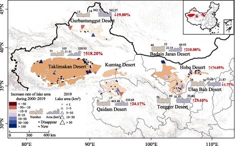
Figure 3 Regional characteristics of changes in
the number and area of lakes in China??s eight deserts from 2000 to 2019
4.2.2 Seasonal Variation Characteristics of Desert Lake
In
this study, the seasonal water body is defined as the difference between the
range of the largest water body in a year and the permanent water body in a
year. The proportion of the seasonal water body is the ratio of the seasonal
water body to the largest water body. The deserts that are greatly affected by
seasonal water changes, that is, those with more than 50% seasonal water in most
years, are the Taklimakan, Tengger, Ulan Buhe, and Kumtag Deserts. In the
Taklimakan Desert, the seasonal water body proportion peaked at 88.49% in 2000
and gradually decreased with the increase in lake area to 46.26% in 2019. The
proportion of seasonal water bodies in Tengger Desert is very stable, basically
fluctuating between 60% and 70%, and stable at approximately 63.64%. In
addition, the number and area of lakes in Tengger Desert are also relatively
stable based on the inter-annual variation. The proportion of seasonal water
bodies in the Ulan Buh desert is almost above 60%, only decreasing by 55.92% in
3 years from 2009 to 2011, and reaching the highest value of 76.80% in 2016.
The lake area of the desert itself is relatively small. Hence, the seasonal
water body has a great influence on the overall lake area.
Deserts that are
less affected by seasonal water bodies, that is, the Gurbantunggut, Qaidam, and
Badain Jaran Deserts, account for less than 50% of the seasonal water in most
years. Gurbantunggut Desert is the least affected by seasonal water bodies,
accounting for less than 30% in all years and even only 7.50% in 2019. The
particularity of this desert lies in that the area of Ebi Lake accounts for
more than 90%, and the seasonal fluctuation of large lakes is relatively small.
The seasonal variation of lakes in the Qaidam Desert is not stable. In 2009,
the proportion of seasonal water reached 57.72% but decreased by 25.24% in
2012, but it is between 30% and 50% in most years. The proportion of seasonal
water bodies in the Badain Jaran Desert also shows an increasing trend with the
increase in lake area year by year. The proportion of seasonal water bodies in
the Badian Jadran Desert was 26.16% in 2000, but it has been more than 50%
since 2016. Given that the lake area of the Kubuqi Desert is less than 10 km², the seasonal water body
proportion greatly fluctuates, with the lowest of 27.99% in 2011 and the
highest of 75.05% in 2019. The annual average is approximately 52.26%.
4.2.3 Discussion
on the Driving Factor
Adequate water supply is the basis for
maintaining desert lakes. However, there is no unified conclusion about the
water source of desert lakes, and the existing views are mainly summarized as
precipitation supply, remote source supply, and near-source supply. Meteoric
water recharge believes that lakes are mainly replenished by local meteoric
water and groundwater formed by precipitation infiltration[14,15].
Remote replenishment believes that lake water is derived from precipitation and
snow and ice meltwater in remote areas and is replenished through underground
leakage channels, such as faults and fissures[16,17]. Near-source
replenishment believes that the lake water comes from the precipitation
infiltration recharge around the desert[18]. This study does not
involve the specific discussion on the replenishment sources and routes of
desert lakes. However, the replenishment ways of desert lakes summarized in the
existing studies are highly susceptible to the impact of climate change. Years
of observation data show that the climate in northwest China, where desert
lakes are concentrated, has shown a warming and humidification trend of rising
temperature and increasing precipitation in the past 20 years[19?C21].
Desert lakes are less directly affected by human activities, and the
significantly increased precipitation can explain the significant expansion
trend of lakes in the eight deserts of China in the past 20 years. Not only the
desert lakes but also most of the lakes in northwest China are less affected by
human activities and show a significant trend of expansion. By contrast, the
fluctuation characteristics of desert lakes are significant, indicating that
desert lakes have sensitive response characteristics to climate change. In
addition, the lake changes in the arid and semi-arid areas of northwest China,
especially in the Taklimakan Desert, are also affected by anthropogenic
measures, such as the ecological water replenishment of Taitma Lake in recent
years, which is one of the important reasons for the significant expansion of
the lake area. Nonetheless, the wet climate and a certain degree of artificial
ecological restoration can explain China??s desert lakes in the recent 20 year
trend of scale expansion of the overall features. The difference between the
desert and desert lakes within the change characteristics of the regional
diversity also requires a combination of more detailed meteorological and
hydrological, geological, geomorphic multi-factor comprehensive analysis. This
mechanism is the only approach to grasp the mechanism of desert change after
exposing its features.
4.3 Comparative Analysis on the Dataset
Existing
studies on the temporal and spatial changes of desert lakes in China mainly
focus on the Badian Jaran and Tengger Deserts. Research[2,4] has
shown that the area and number of lakes in these two deserts have displayed a
certain trend of increase since 2000, which is basically consistent with our
research conclusion. However, the specific change range significantly varied. Yan et al. (2020)[2] found that
the area of lakes larger than 0.1 km2 in Tengger Desert increased by
6.85 km2 during 2000?C2015. Meanwhile, this study exhibited that the
maximum water area of lakes increased by 0.08 km2 during this
period. The main reason for the difference is that the two studies used
different data sources and definition criteria for the lake extent. Yan et al. (2020) used the instantaneous
water range presented by remote sensing images at a certain time to define the
lake range of the year[2]. Specifically, they had utilized TM or OLI
images to extract the water range at a certain time between June and September
every year when the cloud cover was less than 10%. The lake range in this study
is a statistical concept. The maximum and permanent boundary ranges of lake
water can be obtained by using all available images and the distribution
frequency data of water bodies in the year. The above-mentioned two ideas have
been applied in the study of lake temporal and spatial changes at a large regional
scale. However, we believe that the latter is more reasonable for desert lakes.
The main reason lies in that the desert lake itself is small, and the proportion of seasonal water is much larger than that of
large lakes. Therefore, if instantaneous water is used for inter-annual
analysis, then the analytical result is easily affected by the annual
fluctuation of water. In this study, the annual maximum water body range and
annual permanent water body range are simultaneously provided, avoiding the interference
of seasonal water bodies introduced by the difference of data time phase
selection.
5 Discussion and Conclusion
This
dataset provides spatial and temporal distribution data of lakes (>0.1 km2)
situated in eight deserts of China from 2000 to 2019. In combination with the
data analysis, the number and area of lakes in the eight deserts of China have
shown a significant interannual variation in the last 20 years. Accordingly,
the desert lakes showed a significant expansion trend, with the total area increasing
by 17.24% from 1,502.63 km2 in 2000 to 1,761.65 km2 in
2019. The lakes in Taklimakan, Badain Jaran, Qaidam, Tengger, Kubuqi, and
Kumtag Deserts have exhibited an expanding trend. By contrast, the lakes in
Gurbantunggut and Ulan Buhe Deserts showed an overall shrinking trend. The
largest increase in lake area was in the Taklimakan Desert, and it was caused
by the rapid expansion of several lakes, including the Inkur Sea, Sesayet, and
Tetema Lakes. The largest decrease was observed in the Gurbantungut Desert.
Compared with the existing analysis results, this study generated the maximum
water range and permanent water range of the lake in a year based on the water
frequency data. This method overcomes the defect that the annual variation
analysis of desert lakes is easily affected by the seasonal water body when
using a single instantaneous water range, and makes the annual analysis results
more reasonable and reliable. This dataset provides long-term and
high-precision spatial and temporal distribution information of desert lakes in
China in the past 20 years, which can provide basic data for water resource
utilization and ecological environmental protection in desert areas. Moreover,
this dataset also provides scientific reference for discussing the response
characteristics of hydroecology in arid and semi-arid areas of China under the
background of climate change.
Author Contributions
Liu, K., Song C. Q. designed the
algorithms of dataset. Feng, Q. Y., Fan, C. Y. contributed to the
data processing and analysis. Feng, Q. Y., Liu, K. wrote the data paper.
Conflicts of Interest
The
authors declare no conflicts of interest.
References
[1]
Lu,
H., Yi, S., Xu, Z., et al. Chinese
deserts and sand fields in Last Glacial Maximum and Holocene Optimum [J]. Chinese Science Bulletin, 2013, 58(23):
2775‒2783.
[2]
Yan, Y. Z., Li, S., Lu, J. F., et al. Tengger Desert lake area and
quantity during 1975‒2015 [J]. China
Desert, 2020, 40(4): 183‒189.
[3]
Ma, R. H., Yang, G. S., Duan, H.
T., et al. Number, area, and spatial
distribution of Chinese lakes [J]. Chinese
Science: Earth Sciences, 2011, 41(3):
394‒401.
[4]
Zhang, Z. Y., Wang, N. A., Wu,
Y., et al. Remote sensing analysis of
spatial variation in the hinterland of Badanjaran Desert 1973‒2010 [J]. Lake Science, 2013, 25 (4): 514‒520.
[5]
Shao, T. J., Zhao, J. B., Dong,
Q. B. Chemical characteristics of Badanjaran Desert [J]. Geography, 2011, 66(5): 662‒672.
[6]
Cao,
L., Nie, Z. L., Jiang, G. L., et al. Interpretation
of water changes in Badanjaran Desert lakes based on GF
satellite [J]. People??s Yellow River, 2020, 42(7): 40‒45.
[7]
Messager,
M. L., Lehner, B., Grill, G., et al.
Estimating the volume and age of water stored in global lakes using a
geo-statistical approach [J]. Nature
communications, 2016, 7: 13603.
[8]
Pekel,
J. F., Cottam, A., Gorelick, N., et al.
High-resolution mapping of global surface water and its long-term changes [J]. Nature, 2016, 540(7633): 418?C422.
[9]
Pickens,
A. H., Hansen, M. C., Hancher, M., et al. Mapping and sampling to
characterize global inland water dynamics from 1999 to 2018 with full Landsat
time-series [J]. Remote Sensing of Environment,
2020, 243: 111792.
[10] Feng, Q. Y., Liu, K., Fan, C. Y., et al. Dataset of temporal-spatial distribution of lakes in the
eight deserts of China (2000?C2019) [J/DB/OL]. Digital Journal of Global
Change Data Repository, 2021. https://doi.org/10.3974/geodb.2021.09.05.V1.
https://cstr.escience.org.cn/CSTR:20146.11.2021.09.05.V1.
[11] GCdataPR Editorial Office. GCdataPR data sharing policy [OL].
https://doi.org/10.3974/dp.policy.2014.05 (Updated 2017).
[12] The Western China Environmental and Ecological Science Data Center. China
Desert 1:100,000 distribution atlas [EB/OL]. http://westdc.westgis.ac.cn. 2006-08-10.
[13] Division of Science and Technology and Climate Change, China
Meteorological Administration. China climate bulletin (2016) [R].
Meteorological Bulletin. 2017-05-25.
[14] Ma, N. N., Yang, X. P. Hydrochemical and environmental isotope
characteristics of the Badanjaran Desert and its southeastern marginal region
[J].Quaternary study, 2008(4): 702‒711.
[15]
Wang,
T. Several issues in the formation and evolution of the Badanjaran Desert [J]. China Desert, 1990 (1): 32‒43.
[16] Chen, J. S., Zhao, X., Sheng, X. F., et al. Study on the formation mechanism of lakes group and sand
mountain in Badanjaran Desert [J]. Scientific
bulletin, 2006(23): 2789‒2796.
[17] Chen, J. S., Fan, Z. C., Wang, J. Y., et al. Analysis of the Badanjaran Desert lakes and their
downstream groundwater isotopes [J]. GeoJournal,
2003(6): 497‒504.
[18] Ding, H. W., Wang, G. L. Mechanism analysis of lake formation in the
Badanjaran Desert [J]. Drought Zone Study,
2007(1): 1‒7.
[19] Li, M., Sun, H., Q., Su, Z. C. Research progress in the dry and wet
climate change in Northwest China [J]. Geographic
studies, 2021, 40(4): 1180‒1194.
[20] Huang, X. Y., Li, Y. H., Feng, J. Y., et al. Precipitation and extreme arid climate change
characteristics in Northwest China [J]. Ecological
Journal, 2015, 35(5): 1359‒1370.
[21] Hu, Z., Y., Zhou, J. J., Zhang, L. L., et al. Characteristics of dry and wet climate change and drought
evolution in northern China [J]. Ecological
Journal, 2018, 38(6): 1908‒1919.