Vegetation Monitoring Dataset from 31 Plots in Qinghai Lake
Watershed (2018)
Chen, Z. R.,1,2,3
Hou, Y. S.,4 Chen, K. L.,1,2,3* Ma, Y. X.1,2,3 Wang, X. Y.1,2,3
1. College of Geography, Qinghai Normal University, Xining
810008, China;
2. Key Laboratory of Physical Geography and Environmental
Process of Qinghai Province, Qinghai Normal University, Xining 810008, China;
3. Key Laboratory of Surface Process and Ecological
Conservation of the Qinghai?CTibet Plateau, Ministry of Education, Xining
810008, China;
4. Qinghai Lake National Natural Reserve, Forestry
Administration of Qinghai Province, Xining 810007, China
Abstract: The Qinghai Lake
watershed (97??50¢E?C101??20¢E, 36??15¢N?C38??20¢N) is an important natural geographical region in the northeastern
Qinghai?CTibetan Plateau. It is an important part of the ecological security of
the Two Screens and Three Districts region in Qinghai province. The basin has a
rich biodiversity and is a gene pool for Qinghai?CTibetan Plateau species, in
addition to having a typical plateau ecosystem. Vegetation was monitored at 31
sample sites in the basin during 2018 and a vegetation monitoring dataset was
obtained for the Qinghai Lake watershed. The dataset includes: (1) a profile of
the sampling sites and location data; (2) the type of vegetation (temperate
grassland, temperate desert grassland, alpine grassland, temperate desert,
mountain meadow, lowland meadow and alpine meadow); (3) statistics for the main
plant families, genera and species of the seven zonal vegetation types; (4)
statistics for the biomass and available biomass of vegetation in the Qinghai
Lake Nature Reserve, the various bird habitats and the active area for
Przewalski??s gazelle; and (5) an annual comparison of the plant structure and
biomass of the temperate steppe, temperate desert steppe, alpine steppe and
temperate desert.
Keywords: Qinghai Lake watershed; Qinghai?CTibetan Plateau; vegetation monitoring; sample plots
DOI: https://doi.org/10.3974/geodp.
2022.01.10
CSTR: https://cstr.escience.org.cn/CSTR:20146.14.2022.01.10
Dataset Availability Statement:
The dataset
supporting this paper was published and is accessible through the Digital Journal of
Global Change Data Repository at: https://doi.org/10.3974/geodb.2021.09.09.V1 or
https://cstr.escience.org.cn/CSTR:20146.11.2021.09.09.V1.
1 Introduction
Extreme
cold, a lack of oxygen and the harsh climate of the Qinghai?CTibetan Plateau
have resulted in a sensitive and vulnerable ecological environment. Monitoring
the biodiversity of this region is important in evaluating the effectiveness of
conservation projects and in wider studies of global climate change[1].
Vegetation is the basis of ecosystems and plays an important part in their operation and structure[2]. Changes in
vegetation in the alpine region of the Qinghai?CTibetan Plateau are important in
studies of the region??s climate and ecology[3]. Grassland is
the main type of vegetation in the Qinghai Lake watershed[4], with
2.08 ?? 106 ha of grassland accounting for 70.26% of the total area.
There are seven
types of grassland in the Qinghai Lake watershed, among which the largest is
alpine meadow, accounting for 68.95% of the total area of grassland. Temperate
steppe vegetation is distributed in the lake basin and river valleys and has
adapted to the cold, dry climate, showing a trend from east to west[5?C7].
The yield of fresh grass from the natural grasslands is 2.56 ?? 103
kg/ha, with the highest yield in the lowland meadow grasslands, followed by
mountain meadows; the lowest yield is in the alpine desert areas[8].
A total of 91.22% of the grassland area in the watershed receives grassland
compensation (government subsidy). There are different degrees of degradation
of the grassland, with 1.88 ?? 105 ha of lightly degraded grassland,
accounting for 9.00% of the total grassland area, and 8.58 ?? 105 ha
of moderately degraded grassland area, accounting for 41.19% of the total
grassland area. There is also 2.15 ?? 105 ha of seriously degraded
grassland, accounting for 10.34% of the total grassland area.
The Qinghai Lake
watershed lies in the northeast of the Qinghai?CTibetan Plateau and is an
independent and integrated natural geographical unit[9,10]. This
dataset is based on vegetation monitoring samples taken by the National Nature
Reserve Authority of Qinghai Lake[11] from 7 to 14 August 2018 and
consists of 31 vegetation samples from Egg Island, Cormorant Island, Haixinshan
Island, the Buha estuary, Xianggong village, Quanwan, the Heimahe river,
Zhengquhu, Hadatan, the Quanji estuary, the Nanren wetland, the Ganzi river,
Sand island, Ketu, Xiaobaohu lake, the Shantung river wetland, the Jiangxi
ditch rural community summer pasture, the Buha river, the upper reaches of the
Shaliu river, Kot?? sheep farm, the Shantung river, Zhenyuan, Qinghai Lake farm,
Halgai, Kuerma and Shengge.
2 Metadata of the Dataset
Table
1 summarizes the metadata of the Monitoring vegetation dataset from 31 sample
sites in Qinghai Lake basin (2018)[12]. It
includes the dataset full name, short name, authors, year of the dataset, spatial
resolution, data format, data size, data files, data publisher, and data
sharing policy, etc.
3 Methods
Vegetation
was monitored in 31 sample plots around Qinghai Lake to determine the
vegetation structure, plant frequency and ground biomass at 16 sites of Procapra
przewalskii (Przewalski??s gazelle) and bird habitat. Site-specific
monitoring was carried out and representative plots selected for vegetation
monitoring in each region, starting with detailed records of the basic
characteristics of the plots, including the administrative region, vegetation
type, altitude, geographical location, general geomorphological features,
general soil features, the hydrological and hydrogeological conditions,
utilization mode and status. One vegetation structure quadrate of 1 m2,
ten vegetation frequency quadrates of 1 m2 and one vegetation
structure quadrate of 25 m2 for shrub or tall herbage (Achnatherum
splendens only) were measured at the same time. The above-ground biomass of
the vegetation was measured in the active area, the key bird habitat and the
bird breeding areas. Two to three biomass samples were taken from each plot and
all samples were fixed and monitored over a number of years.
Table 1 Metadata summary of
the Monitoring vegetation dataset from 31 sample sites in Qinghai Lake basin (2018)
|
Items
|
Description
|
|
Dataset full name
|
Monitoring vegetation
dataset from 31 sample sites in Qinghai Lake basin (2018)
|
|
Dataset short
name
|
Vegetation_QinghaiLakeBasin2018
|
|
Authors
|
Chen, Z. R., Qinghai
Normal University, 424142312@qq.com
Hou, Y. S., Qinghai Lake
National Natural Reserve, Forestry Administration of Qinghai Province,
823996451 @qq.com
Chen, K. L.,
Qinghai Normal University, ckl7813@163.com
Ma, Y. X.,
Qinghai Normal University, 346404980@qq.com
Wang, X. Y.,
Qinghai Normal University, 245003744@qq.com
|
|
Geographical region
|
Qinghai Lake
watershed
|
|
Year
|
2018
|
|
Data format
|
.shp, .xlsx
|
|
|
|
Data size
|
85 KB
|
|
|
|
Data files
|
9 (compressed to
2 files)
|
|
Foundations
|
Ministry of
Science and Technology of P. R. China (2019QZKK0405); National Natural
Science Foundation of China (41661023); Qinghai province (2020-ZJ-Y06)
|
|
Data publisher
|
Global Change Research Data Publishing & Repository,
http://www.geodoi.ac.cn
|
|
Address
|
No. 11A, Datun
Road, Chaoyang District, Beijing 100101, China
|
|
Data sharing
policy
|
Data from the Global
Change Research Data Publishing & Repository includes metadata, datasets (in the Digital Journal of Global Change Data Repository), and
publications (in the Journal of Global Change Data & Discovery). Data sharing policy includes: (1) Data are openly
available and can be free downloaded via the Internet; (2) End users are
encouraged to use Data subject to citation; (3) Users, who are by definition
also value-added service providers, are welcome to redistribute Data
subject to written permission from the GCdataPR Editorial Office and the
issuance of a Data redistribution license; and (4) If Data are used to
compile new datasets, the ??ten per cent principal?? should be followed such
that Data records utilized should not surpass 10% of the new
dataset contents, while sources should be clearly noted in suitable places in
the new dataset[13]
|
|
Communication and searchable system
|
DOI, CSTR, Crossref, DCI, CSCD,
CNKI, SciEngine, WDS/ISC, GEOSS
|
Vegetation
coverage and biomass of shrub or tall herbaceous plots were calculated as
follows:
Vegetation
coverage = herb sample square coverage ?? (1 − total coverage of shrubs or tall
herbs) + total coverage of shrubs or tall herbs
The total
coverage of shrubs or tall herbs was equal to:
??(standard plant length ?? standard plant width ?? p/4 ?? standard plant number) / sample area
The total
vegetation biomass of each sample plot was equal to:
total biomass of
various shrubs or tall herbs shrubs or tall herbs area + average biomass of
sample square ?? (1 − total coverage of shrubs or tall herbs)
4 Data Results
4.1 Data Composition
The dataset includes: (1) the profile of the
sample site monitored and location data; (2) the structure of the vegetation
type in temperate grasslands, temperate desert grasslands, alpine grasslands,
temperate deserts, mountain meadows, lowland meadows and alpine meadows; (3)
statistics for the main plant families, including the genera and species of the
seven vegetation zones; (4) statistics for the total and available biomass of
vegetation in Qinghai Lake Nature Reserve, the bird habitat and the area in
which Przewalski??s gazelle is active; (5) an annual comparison of plant
structure and biomass of the temperate steppe, temperate desert steppe, alpine
steppe and temperate desert. The data are stored in .shp and .xlsx formats and
the dataset consists of nine data files with a data size of 85 KB (compressed
to two files to give 73.6 KB).
|
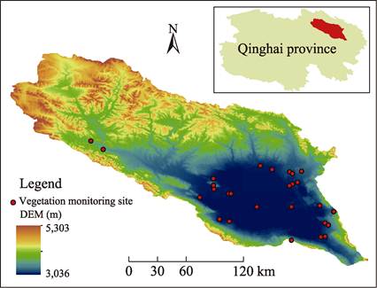
Figure
1 Monitoring sites
for vegetation in the Qinghai Lake watershed in 2018
|
4.2 Data Products
Thirty-one
plots were set up in 30 areas, including Egg Island, Cormorant Island and
Haixinshan Island (Figure 1), among which seven plots were temperate grassland
and one plot was temperate desert grassland. There were two alpine grassland
plots, two temperate desert plots, two mountain meadow plots, one lowland
meadow plot, 15 alpine meadow plots and one weed plot.
The results of
vegetation monitoring in Qinghai Lake valley in 2018 showed that the average
heights of the vegetative and reproductive shoots were 11.50 and 22.90 cm,
respectively. The mean heights of the vegetative and reproductive shoots of the
dominant species were 16.10 and 27.70 cm, respectively. Vegetation covered 72%
of the total area and the dominant species covered 38% of the total area. The
average biomass of vegetation was 3,196.22 kg/ha, with 59.67% of the total
biomass consisting of sedge and Gramineae species. These monitoring data
indicate that the ecological environment of vegetation growth in Qinghai Lake
Nature Reserve is in a good condition.
The carrying
capacity of the vegetation in the active area of pronghorn was 91,378 sheep
units, 20,214 more than in 2016. The carrying capacity for Przewalski??s gazelle
was highest in the East Lake area, with 33,486 sheep units, an increase of 4,426
from 2016, and the lowest was in the Shengge area, with 4,221 sheep units, an
increase of 292 from 2016. Compared with the average values in previous years,
the biomass of the five vegetation types showed an increasing trend in the
temperate desert steppe, whereas the biomass of the other vegetation types
showed a decreasing trend. There was more precipitation and lower temperatures
in 2018 than in previous years, resulting in stunted plant growth and a lower
biomass. Measurements of the above-ground biomass of ten vegetation types in
Qinghai Lake Nature Reserve showed that the
average total above-ground biomass was 2,759.20 kg/ha, of which gramineae was 1,208.50
kg/ha, accounting for 43.80% of the total biomass, cyperaceae was 78.67 kg/ha,
accounting for 2.85%, leguminosae was 353.47 kg/ha, accounting for 12.81%, and
other families were 1,118.56 kg/ha, accounting for 26.24%.
5 Discussion and Conclusion
This
dataset is based on vegetation monitoring samples collected by the Qinghai Lake
National Nature Reserve Authority over a number of years. Thirty-one sample
plots were set up for eight days from 7 to 14 August 2018 in 30 areas,
including Egg Island, Cormorant Island and Sea Heart Hill Island. The sample plots
included seven plots with temperate steppe vegetation, one sample plot with
temperate desert steppe vegetation, two sample plots with alpine steppe vegetation, two sample plots with temperate desert
vegetation, two sample plots with mountain meadow vegetation and one sample
plot with lowland meadow vegetation. There were 15 sample plots and one sample
plot of weeds in the alpine meadow region.
Vegetation
monitoring in the fragile and sensitive ecological areas of the Qinghai Lake
watershed provides an important basis for maintaining the good ecological
environment of Qinghai Lake and expanding Qinghai Lake National Park. It also
provides data for the protection and restoration of the Qinghai?CTibetan Plateau
ecosystem. The Qinghai provincial party committee and provincial government are
determined to ??Contribute Ecology to the Country??, to implement ??One Excellent
and Two High??, take the lead in building a national park demonstration province
and speed up ecological protection and high-quality development in the Yellow
watershed. This will allow them to take the lead in turning the Qinghai?CTibetan
Plateau into an ecologically important region, both domestically and
internationally. Ecological protection has been given a high priority and
vegetation monitoring has been used to protect the ecological environment of
the Qinghai Lake watershed to ensure a ??Big, Beautiful, Clean and Good??
background for Qinghai Lake.
Author Contributions
Chen, Z. R. and Chen, K. L. designed the algorithms
for the dataset. Hou, Y. S., Ma, Y. X. and Wang, X. Y. contributed to data
processing and analysis and Chen, Z. R. wrote the paper.
Conflicts of Interest
The authors declare no conflicts of interest.
References
[1]
Zhi, Y.
J., Yi, J. F., Liu, W., et al. Monitoring of wintering waterbirds in the Nanji Wetland National
Nature Reserve of Poyang Lake [J]. Chinese
Journal of Ecology, 2020, 39(7): 2400?C2407.
[2]
Gong, Z., Li, M. G., Yan, F. X.
Vegetation coverage monitoring for Tibet Plateau ecological shelter zone [J]. Geospatial Information, 2020, 18(5):
111?C114, 8.
[3]
Gao, L. M., Zhang, L. L.
Spatiotemporal dynamics of the vegetation coverage in Qinghai Lake basin [J]. Journal of Geo-information Science,
2019, 21(9): 1318?C1329.
[4]
Chen, J. Causes and legal
countermeasures of grassland ecological damage around Qinghai Lake [J]. Tibetan Plateau Forum, 2016, 4(3):
36?C41.
[5]
Zhang, X. Study on ecological
compensation standard of vegetation in Qinghai Lake watershed based on
ecological health [D]. Xining: Qinghai Normal University, 2016.
[6]
Ma, W. W. Study on remote
sensing retrieval method of grassland type and its quality parameters [D]. Shanghai: Chinese Academy of Sciences
(Shanghai Institute of Technical Physics), 2015.
[7]
Lu, B. L. Landscape pattern
change and its impact on soil organic carbon pool in the Qinghai Lake watershed
[D]. Xining: Qinghai Normal University, 2013.
[8]
Chen, X. Q. Assessment of
eco-environmental sensitivity in Qinghai Lake watershed [D]. Xining: Qinghai
Normal University, 2012.
[9]
Zhang, L. L., Gao, L. M., Chen,
K. L. Variation characteristics of radiation balance and surface albedo in the
Wayan Mountain wetland of the Qinghai Lake watershed [J]. Journal of Glaciology and Geocryology, 2018, 40(6): 1216?C1222
[10]
Gao, L. M., Zhang, L. L., Chen,
K. L. Microclimate characteristics of wetlands in the Qinghai Lake watershed [J].
Arid Zone Research, 2019, 36(1):
186?C192.
[11]
Hou, Y. S., He, Y. B., Xing, Z.,
et al. Diversity and distribution of
waterbirds in Qinghai Lake National Nature Reserve [J]. Zoological Systematics, 2009, 34(1): 184?C187.
[12]
Chen, Z. R., Hou, Y. S., Chen,
K. L., et al. Monitoring vegetation dataset from 31
sample sites in Qinghai Lake basin (2018) [J/DB/OL]. Digital Journal of Global
Change Data Repository, 2021. https://doi.org/ 10.3974/geodb.2021.09.09.V1.
https://cstr.escience.org.cn/CSTR:20146.11.2021.09.09.V1.
[13]
GCdataPR Editorial Office.
GCdataPR data sharing policy [OL]. https://doi.org/10.3974/dp.policy.
2014.05 (Updated 2017).