Global Change Data Encyclopedia
North Island, New Zealand
Lv, T. T.1 Tao, Z.1 Shi, R. X.2 Liu, C.2*
1. Aerospace Information Research Institute, Chinese
Academy of Sciences, Beijing 100101, China;
2. Institute of Geographic Sciences and Natural Resources
Research, Chinese Academy of Sciences, Beijing 100101, China
Keywords: North Island; New Zealand; Pacific Ocean; data
encyclopedia
|
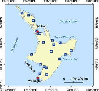
Figure
1 Map of the North Island (.shp
format)
|
The North Island is located in the northeastern of New Zealand,
southeast of Australia, and the western of the South Pacific Ocean. It is separated
25.80 km from South Island by Cook Strait. The geo-location of the North Island
is between 34??23??36??S and
41??36??51??S, 172??38??35??E, and 178??33??2??E[1?C2] (Figure 1, 2).
The North Island is the
smaller island in the two principal islands of New Zealand[3]. The
total area of the North Island is 114,052.58 km² (Albers Projection),
and the total coastline is 7,609.73 km (Lambert Projection). The North Island
of New Zealand has a sub-tropical climate with countless islands and small
bays. The four seasons are distinct and the average annual temperature is
around 12 ºC.
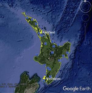
Figure 2 Map of the North
Island (.kmz
format)
The coastline of the North Island is tortuous.
Prentice Bay and Hawkes Bay are two famous
bays on the North Island. The North Island is dominated by hilly landforms,
with many volcanoes in the central part. The most famous volcanoes are Ruapehu,
Egmont, and Talavera. Lake Taupo, the island??s largest lake, is also the largest
lake in New Zealand. New Zealand??s capital, Wellington, is located at the
southern end of the island, while the largest city, Auckland, is located in the
north, and most of New Zealand??s residents live in these two cities.
The dataset was
developed based on Google Earth and related maps and references[2?C3].
The dataset consists of 26 data files and archived in the .kmz and .shp[4]
data formats with a data size of 24.2 MB (Compressed to 22.7 MB in three
files).
References
[1]
Sino Maps
Press. Map of New Zealand [M]. Beijing: Sino Maps Press, 2016.
[2]
Liu, C.,
Shi, R. X., Zhang, Y. H., et al.
Global multiple-scale shorelines dataset based on Google Earth images (2015)
[DB/OL]. Global Change Data Repository, 2019. DOI: 10.3974/geodb.2019.04.13.V1.
[3]
Lv, T. T.,
Tao, Z., Shi, R. X., et al. North
Island, New Zealand [DB/OL]. Global Change Data Repository, 2020. DOI:
10.3974/geodb.2020.02.06.V1.
Data
Computing Environment
[4]
ESRI.
ArcGIS campus license of Institute of Geographic Sciences and Natural Resources
Research, Chinese Academy of Sciences.
URL for Data
Downloading
http://www.geodoi.ac.cn/WebEn/doi.aspx?Id=1428.
Or search
through: http://www.geodoi.ac.cn.