Progress of the Asia-Oceania Group on Earth Observations
(AOGEO) Programme
Wu, J. J.1 Huang, Z. R.2 Liu, J. L.1 Liang, L.2 Liu, Q. H.1* Zhong, B.1 Yang,
A. X.1
1. Aerospace Information Research Institute, Chinese
Academy of Sciences, Beijing 100101, China;
2. School of Geography, Geomatics and Planning, Jiangsu
Normal University, Xuzhou 210023, China
Abstract: The Asia-Oceania
Group on Earth Observations (AOGEO) Programme, as a
key component of the integrated Earth observation system for Asia and Oceania,
aims to promote sharing of Earth observation data and enhance technical
capacity in the region. The mission is important for deepening international
cooperation to meet the challenges of global environmental change. In the
context of the surging global demand for Earth observation data and the
increasing urgency for regional environmental protection, disaster early
warning and resource management, the cutting-edge progress of AOGEO is of great
significance to promote regional development. This paper evaluates the China??s
Decadal Implementation Plan for the Global Earth Observation System of Systems
(GEOSS) (2016–2025), and systematically introduces the latest progress of the
AOGEO task group in several key areas, such as water cycle, biodiversity,
environmental monitoring and protection. These advances have not only significantly
fostered the popularization and application of Earth observation technology in
the subregion, but also provided indispensable support and supplement for
further improvement of the global Earth observation system. In addition, this
paper presents an in-depth analysis of the contributions of AOGEO co-leading
countries in the field of Earth observation, covering policy formulation,
infrastructure construction, investment in scientific research projects and so
on. These contributions not only greatly improve the Earth observation capabilities
of countries and the region in general, but also lay a solid foundation for
global environmental management towards the realization of sustainable
development goals. Finally, based on the current status of development and
challenges of AOGEO, this paper puts forward the direction of strategic
development with certain pragmatic measures, in order to further strengthen
regional cooperation, promote continuous innovation and application of Earth
observation technology, and improve the overall efficiency of the global Earth
observation system.
Keywords: GEO; Earth observation programme;
subregion; decadal implementation plan; national contribution; capacity
building
DOI: https://doi.org/10.3974/geodp.2024.04.04
CSTR: https://cstr.escience.org.cn/CSTR:20146.14.2024.04.04
1 Introduction
With
the aggravation of global warming, resource shortage and environmental
deterioration, Earth observation technology plays an increasingly important
role in formulation of global sustainable development strategies. In response
to the call of Earth observation organizations, China formulated its Decadal
Implementation Plan for GEOSS (2016–2025) in 2016[1], aimed to
strengthen the integration of domestic Earth observation resources and systems
and form a global integrated Earth observation infrastructure and application
technology system, as an effort to contribute to global sustainable
development.
In the past decade
or so, China has made remarkable progress in the field of Earth observation technology. Satellite remote sensing, unmanned
aerial vehicles, ground observation stations and other diverse
observation facilities have been developed and continuously improved, data
processing and analysis capabilities have also been greatly enhanced, providing
strong support for the acquisition and application of Earth observation data. At the same time, China also actively seeks
opportunities for international collaborations to promote the
development and applications of Earth observation technology, and has established extensive cooperative relations with
many countries and international organizations[2,3].
However, Earth
observation technology still faces many challenges. On the one hand, with the
increasing complexity of global environmental issues, the demand for Earth
observation data is becoming more and more diversified. On the other hand, the
acquisition, processing and application of Earth observation data are still
restricted by many aspects such as technological limitations, funding, and
policies. Therefore, China needs to unrelentingly fuel investments and
strengthen technological innovations and personnel training to promote the
steadfast development of Earth observation technology[1].
The purpose of this
paper is to provide a comprehensive evaluation of the progress of AOGEO,
especially with regards to the implementation of the Decadal Implementation
Plan for GEOSS (2016–2025), as well as the
cooperation and development in the field of Earth observation within the
subregion. Through in-depth analysis of the development history of AOGEO
activities, the progress of various task groups and China??s participation and
contribution in the construction of global Earth observation systems, the trends
and contributions of different countries and international organizations in
Asia in promoting the development of Earth observation are elaborated. Finally,
the strategic direction and measures for the future development of AOGEO are
proposed.
2 Progress in GEO Strategic Plan
2016–2025: Implementing GEOSS
China??s
Decadal Implementation Plan aims to build an efficient and globally connected
integrated Earth observation system, provide high-quality Earth observation
data and information products to the world,
support sustainable development, foster disaster prevention and reduction,
tackle key environmental issues, actively participate in international
cooperation, and promote the interconnection and data sharing of global
observation infrastructure. To contribute to the achievement of the United
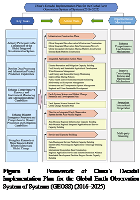
Nations 2030 Sustainable Development Goals (SDGs), the key mission framework is
shown in Figure 1[1].
The Asia-Oceania Group on Earth observations
Program is an important part of the Action Plan of the 2016–2025 10-year plan.
Table 1 lists in chronological order of the progress and implementation of
AOGEO from 2016 to 2024, and summarizes the main Earth observation activities
that China has organized and participated in in recent years, including close
cooperation with GEO, participation in international seminars and training
courses, all are aimed at strengthening international cooperation for
addressing global challenges. These activities cover many aspects, including
international cooperation, capacity building, data sharing and policy
improvement. By enumerating these activities, we can see that Earth observation
organizations have achieved remarkable results in promoting the construction of
a global integrated Earth observation system
and in improving the capacity of comprehensive monitoring and
application services for natural resources and the environment. At the same
 time, they also reflect the
important role and responsibility of China in the development of GEO.
time, they also reflect the
important role and responsibility of China in the development of GEO.
In retrospect on the
development process from 2016 to 2024, AOGEO has launched a series of international seminars, capacity building training
courses, and issued the Beijing Declaration,
Changzhou Declaration, Macao Declaration, etc., making significant
contributions to the international community in multiple dimensions. China has
actively participated in the construction
of the global integrated Earth observation system, service and capacity
building, the development of data
processing and information product
generation capacity,
infrastructure construction plans, the enhancement of comprehensive coordination mechanisms, the strengthening of international
cooperation, and the improvement of data sharing policies and operational
mechanisms.
By organizing
international seminars and training courses, AOGEO has strengthened data sharing,
technology exchange and international cooperation, especially in the areas of
climate change response, disaster risk reduction and sustainable development.
Its global Earth observation technology has provided countries with efficient
tools and methods, and promoted technical cooperation and data infrastructure construction[2]. China has made
important progress in data processing, information product generation, resource
and environmental monitoring systems. Through training courses and other
related capacity building activities, China has provided high-quality data and
information products to global users, and provided theoretical support for earth
system science and global change research. Looking ahead, AOGEO will continue
to strengthen international cooperation, improve monitoring and application
capabilities, improve data sharing mechanisms, promote technological
innovation, and make greater contributions to global environmental change and
disaster management[3].
3 Actions of the AOGEO Task Groups
3.1 Asian Water Cycle
Initiative
The Asian Water Cycle
Initiative (AWCI) continues to advocate the development of an Operational
Satellite System for Sustainability and Resilience (OSS-SR) in global water
management activities, and its initiative has been adopted by the United
Nations as a Water Cycle Integrator (WCI). AWCI has deployed its platform in
multiple countries, with knock-on effects that reaffirm the importance of local
data, scientific methods combined with socio-economic issues, and
multi-stakeholder engagement in the water-food-energy relationship. Going
forward, AWCI will advance existing activities and accelerate the
implementation of WCI and Earth Intelligence, while expanding collaboration
into areas
Table
1 Implementation of the AOGEO Programme
|
Time
|
Activity name
|
|
2016.04
|
AOGEOSS Initiative Working Group established
|
|
2016.11
|
AOGEOSS Working Group was established in St. Petersburg, Russia
|
|
2017.10
|
GEO
Conference Week in Washington, D.C., U.S.A., GEOARC organized Side Events to launch
the Belt and Road Report and Exchange AOGEOSS Progress
|
|
2018.05
|
AOGEOSS International Symposium held in Deqing,
China
|
|
2018.10
|
GEO Conference Week, AOGEO Symposium, and GEOARC Side Event in Kyoto,
Japan
|
|
2019.04
|
Director of GEO Secretariat visited GEO China Secretariat, Aerospace
Information Research Institute, Chinese Academy of Sciences, etc.
|
|
2019.11
|
Chinese delegation to Canberra, Australia for GEO Conference Week 2019
|
|
2019.11
|
The 12th
International Symposium on Integrated Earth Observation in the Asia-Oceania
Region held in Canberra, Australia
|
|
2020.01
|
AOGEO Overseas Capacity Building Training Course held online
|
|
2020.06
|
GEO Virtual Symposium held online
|
|
2020.10
|
2020
International Training Course on Earth Observation in the Service of
Sustainable Development in Developing Countries began
|
|
2020.10
|
The Third
International Symposium on Integrated Earth Observation Programs in the
Asia-Oceania Region held in Changzhou and the ??Changzhou Declaration?? released
|
|
2021.02
|
Asia-Oceania
Regional and Global Remote Sensing Monitoring of Ecosystems Forum cloud shares
new achievements
|
|
2021.03
|
The 13th International Symposium on Integrated Earth Observation Programs
in the Asia-Oceania Region held online
|
|
2021.07
|
The 4th
International Symposium on Integrated Earth Observation Programs in the Asia
Oceania Region (IEOP-AOA)
|
|
2021.11
|
The 14th AOGEO Symposium and 2021 GEO Week online, GEOARC Side Event
organized
|
|
2022.06
|
The Fifth
International Symposium on Integrated Earth Observation Programs in the
Asia-Oceania Region held in Beijing, ??Beijing Declaration?? issued
|
|
2022.06
|
GEO Virtual Symposium held online
|
|
2022.08
|
2022
International Training Course on Earth Observation Services for Sustainable
Development in Developing Countries held
|
|
2022.09
|
Main Event of the First GEO China Conference held in Beijing
|
|
2022.09
|
The 15th AOGEO Symposium held online
|
|
2023.04
|
Chinese
Delegation Participated in the 60th Executive Committee of the Group on Earth
Observations (GEO) in Switzerland
|
|
2023.05
|
Workshop on China??s Participation in GEO Work Program Projects held in
Beijing
|
|
2023.06
|
The 6th
International Symposium on Integrated Earth Observation Programs in the
Asia-Oceania Region held in Macao, ??Macao Declaration?? released
|
|
2023.06
|
Air and
Space Academy held Mid-term Review Meeting of GEO Collaboration Projects
under National Key R&D Programs
|
|
2023.06
|
2023
International Training Course on Earth Observation Services for Sustainable
Development in Developing Countries held
|
|
2023.10
|
2023 AOGEO Academic Symposium and International Training Course on
Capacity Building held
|
|
2023.11
|
Chinese delegation attended GEO 2023 Conference Week, Cape Town, South
Africa
|
|
2024.09
|
The 16th AOGEO Symposium held in Tokyo, Japan
|
|
2024.09
|
GEO Symposium and ODOK Workshop 2024 held in Hangzhou, China
|
such as sanitation,
poverty, health, and peace to innovate for future prosperity[4].
3.2 Asia-Pacific
Biodiversity Observatory Network
The
Asia-Pacific Biodiversity Observatory Network (APBON) continues international
collaboration on capacity building, data and knowledge sharing for assessing
regional biodiversity data and knowledge gaps to meet international
requirements such as the Convention on Biological Diversity. At present, APBON
is advancing data needs and accessibility assessments and plans to develop
Essential Biodiversity Variables (EBVs), but faces challenges in field data
accessibility[5]. At the same time, APBON strives to align with the
National Biodiversity Strategy and Action Plan (NBSAP) and strengthen
scientific and policy collaboration. In the future, APBON will improve data
accessibility, develop scientific and policy collaboration as a regional high
priority, act as a platform for collaboration, and work with the Group on Earth
observations Biodiversity Observation Network (GEOBON) and GEO communities to
take coordinated action.
3.3 Asia-Oceania Greenhouse
Gas Initiative
The
Asia-Oceania Greenhouse Gas Initiative Group (AO-GHG) has developed a
multi-data integration system that coordinates a growing number of platforms,
such as remote sensing, field observations and inventories, to reduce
uncertainty in greenhouse gas sources and sinks, thereby supporting the
ultimate goal of net zero emissions as required by the Paris Agreement. In
particular, progress has been made with greenhouse gas observation satellites
to meet the requirements of accounting for greenhouse gas budgets. A synthesis
of several models and methods is proposed to obtain robust greenhouse gas
budget estimates. The system will be improved to provide annual and rapid
regional GHG budgets, contributing to the global stocktaking process[6].
3.4 Oceans, Coasts and
Islands
The
Oceans, Coasts and Islands Group is working to build a new Earth observation-based
platform to provide timely, sustainable, accessible and usable Earth
observation data and information to serve researchers, society and
stakeholders, address emerging issues in the region and support sustainable
development. Among them, the development of the Asia Coastal Ocean Gateway
(A-COP) based on satellite remote sensing is one of the core activities aimed
at observing and monitoring persistent environmental problems in the Asian
coastal oceans, such as eutrophication, hypoxia, red tides, etc. In the future,
this task group will reposition its research activities to focus on building
models and algorithms to evaluate these biogeophysical
variables, and introducing these models and algorithms into A-COP for
socio-economic benefits. A prototype of the A-COP is expected to be launched in
2024.
3.5 Agriculture and Food
Security
Asian
Rice Crop Estimation & Monitoring (Asia-RiCE) is
committed to promoting the Sustainable Development Goals, particularly in the
areas of agriculture and food security. During the COVID-19 pandemic, the
organization has advanced rice surveillance in the Asia-Pacific region,
developed advanced rice mapping algorithms, and established an open data
sharing platform. At the same time, through the multilateral network of
agro-meteorological information and rice monitoring, data integration and
regional cooperation have been strengthened to improve the accuracy of rice
yield estimation. Asia-RiCE also works in partnership
with multi-stakeholders to use Earth observation data for rice yield
forecasting and statistical inventory, and to promote research and development cooperation. In 2023, Asia-RiCE continued to deepen the agrometeorological
information and rice monitoring, strengthen capacity building, use machine
learning for data fusion, achieve cloud-based sharing, combine remote sensing
and crop models for rice yield estimation and prediction, and promote research
in rice field water management.
3.6 Environmental
Monitoring and Protection
Environmental
Monitoring and Protection (EMP) has progressed on many fronts, including the
development of algorithms and products, the launch of environmental monitoring
platforms, compilation of annual reports, and fostering international
collaborations. Remote sensing basic products at national and global scales
have been produced using China??s domestic satellite data. The Asia-Oceania
Environmental Monitoring Platform (AOEM) has been developed to facilitate
information sharing. EMP has also organized a number of international
conferences and training events to strengthen Earth observation capacity
building. In addition, the use of Chinese satellite data has provided global
remote sensing data and products for international services and collaborative
applications. Ecosystem research has also been conducted in countries and
regions such as Cambodia, with relevant reports being published.
The task forces
have made remarkable achievements in their respective fields. These
accomplishments not only promote innovations in scientific research, but also
provide strong scientific support for solving global challenges through
international cooperation. They reflect the important role of scientific and
technological innovation in solving global problems, demonstrating the huge
potential of international cooperation in promoting global sustainable
development. In the future, with the persisting progress of science and
technology and the deepening of international cooperation, we firmly believe
that these task forces will continue to make more breakthroughs in their
respective fields and make greater contributions to the sustainable development
of mankind.
4 Contribution of AOGEO Co-lead
Countries
AOGEO
is one of the four regional GEOs in the world, and is jointly led by China,
Japan, Australia, and South Korea. This section focuses on evaluating the key
contributions from AOGEO co-lead countries.
4.1 China
From
2016 to 2024, China actively participated in and hosted a series of
international activities related to Earth observation, covering many fields
such as data sharing, environmental monitoring, climate change, disaster
management and agricultural remote sensing. These activities have been
described in Section 2 and outlined in Table1. Through cooperation with GEO
Secretariat, BRICS and other international organizations, China has made
remarkable progress in promoting the application of Earth observation technology,
promoting regional coordinated development, and enhancing the international
influence. At the same time, China has also played an important role in
organizing AOGEO international seminars and capacity building training courses,
which not only promoted the innovation and application of Earth observation
technology, but also made important contributions to training both senior
scientists and young talents in promoting the realization of sustainable
development goals[1].
Promoting
regional cooperation and platform building: As a co-lead country of AOGEO,
China has successfully held a series of AOGEO workshops, attracting a wide
range of international participants and promoting in-depth exchanges and
cooperation in the fields of data fusion, global eco-environmental monitoring,
and capacity building. In addition, China has actively advocated the
construction of regional cooperation mechanisms and provided strong support for
the capacity building and collaboration network construction of the
comprehensive priority research area in the Asia-Oceania region[7].
Strengthening
international cooperation and exchange: China has organized a series of
??International Training Courses on Earth observation for Sustainable
Development in Developing Countries?? among other related activities, providing
a platform for learning and exchange for young scholars from all over the
world, and promoting the international dissemination and application of Earth
observation technology[8]. At the same time, China has actively
participated in international seminars and training programs to discuss with
other countries on the latest progress and future development direction in the
field of Earth observation.
Promoting data
sharing and emergency response: Through its National Integrated Earth
observation Data Sharing Platform, China has been working closely with
international organizations such as GEOSS
and the United Nations Environment Programme (UNEP)
to share a large number of selected
datasets and enrich global Earth observation data resources[9].
In response to natural disasters overseas, the platform responded promptly,
providing timely data support for relief on the Turkey-Syria earthquake,
hurricane in New Zealand, flood in Peru, and other disasters, demonstrating
China??s strong ability and sense of responsibility in Earth observation data
emergency response[10].
Leading
technological innovation and application: China not only focuses on the
research, development and application of Earth observation technology, but also
actively promotes technological innovation in knowledge transfer. By developing
remote sensing platforms for monitoring global crop conditions, water resources
and drought, China has provided precision agriculture and water resources
monitoring services for many countries, providing strong support for global
food security and alleviation of water shortages among other issues[11,12].
China has also developed environmental observation technology in key regions
such as the Himalayas and island regions, and emphasized its key applications
in disaster reduction, urban and ecological monitoring, all are positive
contributions to global sustainable development[13].
4.2 Japan
As
a co-lead country of AOGEO, Japan has made important contributions in many
ways. A series of AOGEO Symposia were organized from 2016 to 2024 to promote
the sharing and cooperation of Earth observation data and support sustainable
development in the Asian region. In terms of data integration and cloud
computing, Japan has played a key role in integrating and processing
environmental monitoring data using cloud computing and big data technologies.
For example, at the 16th AOGEO Symposium, Japan demonstrated progress in
processing and analyzing large-scale remote sensing data through data cube
technology. These technologies contribute to better monitoring and management
of environmental change, especially in the Himalayas and other high mountain
regions[12].
Environmental
protection and ecosystem restoration: Japan is involved in several
environmental protection and ecosystem restoration projects, including coral
reef protection and coastal zone restoration. Through these projects, Japan is
working to improve the health of coastal and marine ecosystems and strengthen
their resilience to climate change.
International
cooperation and capacity-building: Japan nurtures international cooperation
initiatives in the APEC region, and these efforts contribute to the creation
and provision of geointelligence.
Biodiversity information
sharing mechanism for Asia and the Pacific: Through the BISMaL system, Japan
integrates and shares marine biodiversity information, which not only enriches
the Ocean Biodiversity Information System (OBIS), but also facilitates the
establishment and management of marine protected areas in Japan and other Asian
countries.
Continuously Operating Reference Station (CORS) network: The Japan International
Cooperation Agency (JICA) is working with countries such as Thailand to
enhance the capacity of CORS data centers, using high-precision positioning
technology to support the development of infrastructure, smart agriculture and
automated driving.
OSS-SR training program:
Through the OSS-SR program, Japan has trained experts in Earth observation
utilization and policy development, especially in flood warning system
construction and water disaster response, provided e-learning courses and
hands-on training, and strengthened the capacity of local stakeholders to
respond to natural disasters.
Addressing
global challenges: Japan supports global efforts on climate change, health and
disaster prevention through Official Development
Assistance (ODA) programs. These projects not only help developing
countries address environmental and social challenges, but also contribute to
the achievement of the global Sustainable Development Goals (SDGs).
4.3 Australia
Data
integration and sharing: Australia promotes data integration and sharing
through its geospatial and remote sensing technologies. Australia??s Earth
observation data is widely used in areas such as environmental monitoring,
disaster management and agricultural management. For example, Australia has
provided key data support in land use and cover change monitoring to better
understand and respond to regional environmental change[3]. Through
Australian National Data Cube (ANDS) and Digital Earth Australia (DEA)
programs, Australia provides extensive datasets and support for Earth
observation in the Asia-Pacific region. DEA provides an efficient platform for
processing and analyzing spatiotemporal data from satellites such as Landsat
and Sentinel. These data cover a long-time span, making environmental
monitoring and change analysis more accurate. DEA??s datasets and tools are open
and freely accessible to users, supporting scientific research, policy
development, and public service. Open Data Cube (ODC) is an international
collaborative project that aims to advance the adoption of data cube technology
worldwide. Australia is involved in the project through Geoscience Australia,
providing technical support and data resources. The ODC platform is capable of
efficiently processing large volumes of high-resolution satellite imagery,
providing a powerful tool for scientists and policymakers.
Disaster management
and recovery: Australia is actively involved in disaster management tasks,
particularly in improving early warning and response capacity to natural
disasters such as floods and droughts. Through advanced remote sensing
technology and data analysis, Australia has provided scientific basis and
technical support for disaster response in the region.
Climate change
and environmental protection: The co-lead country has also made important
contributions to combat climate change and to protect the environment. By
monitoring greenhouse gas emissions and land cover change, Australia provides
important data support for environmental protection and climate change
adaptation strategies within the region.
International
cooperation and capacity building: Through cooperation with AOGEO member
countries, several international training and seminars have been conducted to
enhance national capacities in Earth observation and environmental management.
Particularly in the areas of agriculture, forest and water resources
management, Australia has shared its experience and technologies in remote
sensing and GIS applications.
4.4 South Korea
South
Korea has made significant progress in the space sector and established the Korea Aeronautics and Space Administration (KASA) in
2024. It has strengthened policy formulation and international cooperation,
laying the foundation for space development. The five-year plan focuses on the
use of satellite information and improves the data collection and utilization
system. South Korea??s space technology has made remarkable progress, and the
KPLO lunar exploration and the launch of the Nuri-ho rocket demonstrate its
independent research and development strength. Research institutes such as KARI
lead technological innovation and promote continuous breakthroughs in space
research. South Korea actively participates in Earth observation and supports
environmental monitoring, disaster management and sustainable development
through satellite data. The country is poised to strengthen international
cooperation, share satellite data, and jointly address global challenges. KASA
supports the participation of the private sector in the utilization of
satellite data and encourages innovative solutions. The new five-year plan
focuses on promoting civilian-led use of data and strengthening domestic and
foreign cooperation to address global issues.
5 Proposals for AOGEO Development Initiatives
AOGEO??s
future strategic development focuses on three core directions. First,
strengthen regional cooperation strategies to enhance regional Earth
observation capabilities by deepening cooperation mechanisms, promoting
resource sharing, strengthening technical exchanges and jointly addressing
global challenges[14,15]. Second, promote technological innovation
and integration, and use emerging technologies such as artificial intelligence
and big data to improve the processing capacity and application of Earth
observation data, while encouraging research and development innovation and
technological application expansion. The third is to serve the needs of
regional development, provide Earth observation services accurately and
efficiently, support regional economic and social development, monitor the
ecological environment, and pay special attention to the needs of developing
countries in Earth observation technology.
To galvanize the
above-mentioned development strategies, the following measures are proposed.
First, establish a long-term cooperation mechanism, including organizing
regular international seminars, encouraging international cooperation projects,
formulating cooperation framework agreements and project cooperation
guidelines to promote knowledge exchange, technical cooperation and policy
coordination. Second, strengthen personnel training and data sharing, through
the establishment of personnel training funds, hold international training
courses, strengthen cooperation with international organizations, establish
regional data centers, encourage data sharing and strengthen data analysis and
application, promote the efficient use of data. Additionally, pay attention to
regional hotspot issues, conduct targeted research, and provide advice and
decision-support to policy makers to promote sustainable development in Asia
and Oceania.
6 Conclusion
This
paper focuses on the implementation of the China??s Decadal Implementation Plan
for the Global Earth Observation System of Systems (GEOSS) (2016–2025), and
summarizes the progress and contributions of China and other countries within
the Asian region under the framework of GEOSS. Firstly, an assessment was
conducted on the progress of AOGEO task forces in water resources management,
biodiversity conservation, greenhouse gas emissions monitoring, marine and
island environmental protection, agriculture and food security, environmental monitoring and protection. Secondly,
the paper elaborates on the contributions of China, Japan, Australia and
South Korea in platform construction, data contribution and international
cooperation. These countries have actively promoted the development and
application of Earth observation technology by formulating policies, building
infrastructure and conducting scientific research projects, making important
contributions to the improvement of the global Earth observation system.
Finally, suggestions and prospects of future development strategies of AOGEO
and measures of implementation are proposed to further strengthen regional
cooperation, promote the innovation and application of Earth observation
technology, improve the overall efficiency of the global Earth observation
system.
Author Contributions
Wu, J. J., Liu,
J. L. and Liu, Q. H. designed the overall framework of the article review;
Huang, Z. R., Wu, J. J., Liu, J. L. and Liang, L. collected and researched the
progress of AOGEO; Wu, J. J. and Huang, Z. R. drafted the initial manuscript;
Zhong, B. and Yang, A. X. revised the draft of the article.
Conflicts of
Interest
The
authors declare no conflicts of interest.
References
[1]
Group
on Earth Observations. GEO Strategic Plan 2016–2025: Implementing GEOSS [OL].
http://www.earthobservations.org/documents/geo_xi/GEO-XI_06_GEO%20Strategic%20Plan%202016-2025_Implementing%20GEOSS.pdf.
[2]
Gu,
X. F., Zhou, X., Zhang, S. M., et al. Asia-Oceania GEOSS: a GEO
initiative to implement GEOSS for sustainable development in Asia-Oceania [J]. National Remote Sensing Bulletin, 2018, 22(4):
666–671.
[3]
Li, G. Q., Zhang, H. Y., Zhang, L. C., et al.
Development and trend of Earth observation data sharing [J]. National Remote Sensing Bulletin, 2016, 20(5): 979–990.
[4]
Group
on Earth Observations. GEO 2016 Work Programme (v4) [OL].
http://www.earthobserv-ations.org/documents/work_programme/geo_2016_work_programme.pdf.
[5]
Group
on Earth Observations. Group on Earth Observations 10-Year Implementation Plan [OL].
http://www.earthobservations.org/documents/10-Year%20Plan%20Reference%20Document.pdf.
[6]
Wang,
C. J. China is sharing its latest achievements with the world [OL].
https://baijiahao.baidu.com/s?id=1650768863973133436&wfr=spider&for=pc.
[7]
Editorial
office of Journal of Global Change Data & Discovery. Prof. Li, Guoqing was honored the GEO Individual Excellence Award
2021 [J]. Journal of Global Change Data & Discovery, 2021,
5(4): 512. https://doi.org/10.3974/geodp.2021.04.16.
https://cstr.escience.org.cn/CSTR:20146.99.2021.04.16.
[8]
Gao,
Y. L. Bridging the ??digital divide?? in Earth observation: Chinese scientists in
action [OL]. China Science Daily. https://www.cas.cn/cm/ 202206/t20220627_4839503.shtml.
[9]
Aerospace
Information Research Institute, Chinese Academy of Sciences. Colloquium on the
theme ??Open Data Cube?? [OL].
http://aircas.ac.cn/dtxw/hzjl/202005/t20200513_5579006. html.
[10]
Li,
M. X., Zhang, S. M. The current status, trends, and implications of international
scientific and technological cooperation in the field of Earth observation [J].
Remote Sensing Information, 2009(2): 110–113.
[11]
Gu,
X. F., Yu, T., Gao, J., et al. Application-oriented scientific
demonstration research for spaceborne remote sensing [J]. National Remote Sensing Bulletin, 2016, 20(5): 807–826.
[12]
Gu,
X. F. Yu, T., Tian, G. L., et al. Up
to the higher altitude—the new ??three campaigns?? for the development of China
spaceborne remote sensing application [J]. National
Remote Sensing Bulletin, 2016, 20(5): 781–793.
[13]
Zhao,
Z. Q. China leads the way in empowering regional development in Asia and
Oceania with Earth observation technologies [OL].
https://www.cas.cn/cm/202206/t20220620_4838786.shtml.
[14]
Liu, Z. C., Zhang, J., Bai, Y.
Q., et al. The development and
practice of China GEO [J]. National Remote Sensing
Bulletin, 2024, 28(4): 1112–1122.
[15]
National Remote Sensing Center.
On China??s contribution to various aspects of Earth observation in the
Asia-Pacific region [OL]. https:// nrscc.most.cn/.