Sensing Image
Chen, J. Y.1,2 Li, H. W.1* Zhang, G.1 Wang, S.1 Chen, T. Q.1
1. Xi'an
Institute of Optics and Precision Mechanics, Chinese Academy of Sciences, Xi??an
710119, China;
2. University of Chinese Academy of
Sciences, Beijing 100049, China
Abstract: The aircraft is an important target in remote sensing domain. However,
public classification datasets of aircraft types are insufficient, which limits
the research and application of large-scale extraction of aircraft types information by using remote sensing images. This paper
solves the problem of data shortage in classification of aircraft types. First,
we obtain high-resolution remote sensing images containing various airports and
plane types information around the world from public
data sources and select 3,594 pieces of valid aircraft images. Then, we choose
the feature of wing and propeller in remote sensing satellite and divide the
aircraft types into seven level I classifications by employing the attention
mechanism including (1) Swept-back wing air-craft; (2) Swept-back aircraft with
leading edge; (3) Forward-swept wing airplane with trailing edge; (4)
Delta-wing aircraft; (5) Flat-wing aircraft; (6) Propeller aircraft; (7)
Helicopter. Next, 11 level II classifications are obtained according to the
fuselage color and so on. All images are compiled into a classification dataset
of aircraft types based on remote sensing images (OPT-aircraft _v1.0), which is
stored in .png format and consists of 3,594 data files with a size of 69.3 MB.
The datasets not only identify aircraft in a fine-grained manner and simulate
different types of aircraft but also provide experimental data for aircraft
image classification in remote sensing field.
Keywords: remote sensing image classification; the classification dataset
of aircraft types; Google Earth; attention mechanism
Dataset Available Statement:
The dataset supporting this paper was published
at: Chen, J. Y., Li, H. W., Zhang, G.,
Wang, S., Chen, T. Q. Dataset of identifying aircraft groups by remote
sensing images [J/DB/OL]. Digital
Journal of Global Change Data Repository,
2020. DOI: 10.3974/ geodb.2020.03.25.V1.
1 Introduction
Aircraft is a kind of
important target in remote sensing field. It is one of the hotspots to identify
the position, type, and number quickly and accurately during the detection of
aircraft target. The existing fine-grained visual classification dataset of
aircraft is FGVC-aircraft[1], which is collected 120 aircraft types. However, the FGVC-aircraft
dataset collects aircraft photos at close range, which cannot be applied to identification
of aircraft types directly in remote sensing domain. In order to identify and
detect abnormal aircraft, the reference data of aircraft types in remote
sensing observation environment is needed.
To speed up the development
of remote sensing aircraft recognition technology, it is very important to obtain
aircraft classification dataset. The classification dataset of aircraft types
based on remote sensing images (OPT-Aircraft _v1.0) is established from several
airports around the world and corresponding classification criteria to provide a
reference for classification of aircraft types.
2 Metadata of the Dataset
The metadata of the ??Dataset of identifying aircraft groups by remote
sensing images??[2] is summarized
in Table 1. It includes the dataset full name, short name, authors, data
format, data size, data files, data publisher, and data sharing policy, etc.
Table
1 Metadata summary of the dataset
|
Items
|
Description
|
|
Dataset full name
|
Dataset
of identifying aircraft groups by remote sensing images
|
|
Dataset short
name
|
OPT-Aircraft
_v1.0
|
|
Authors
|
Chen,
J. Y., Xi??an Institute of Optics and Precision Mechanics, Chinese Academy of
Sciences, chenjunyu2016@opt.cn
Li, H. W., Xi??an
Institute of Optics and Precision Mechanics, Chinese Academy of Sciences,
lihaiwei@opt.ac.cn
Zhang, G., Xi??an
Institute of Optics and Precision Mechanics, Chinese Academy of Sciences,
gzhang@opt.ac.cn
Wang, S., Xi??an
Institute of Optics and Precision Mechanics, Chinese Academy of Sciences,
wangshuang@opt.ac.cn
Chen, T. Q., Xi??an
Institute of Optics and Precision Mechanics, Chinese Academy of Sciences,
chentieqiao@opt.ac.cn
|
|
Geographical region
|
Lots of airports
around the world Year 1989-2020
|
|
Data format
|
.png Data
size 69.3 MB
|
|
Data files
|
The dataset is
composed of 7 level I and 11 level II.
1. Swept-back
wing aircraft (including 3 level II)
2. Swept-back
aircraft with leading edge (including 2 level II)
3. Forward-swept
wing airplane with trailing edge
4. Delta-wing
aircraft
5. Flat-wing
aircraft (including 2 level II)
6. Propeller
aircraft (including 4 level II)
7. Helicopter
|
|
Foundation
|
Chinese Academy of Sciences (XAB2017B19)
|
|
Data publisher
|
Global Change Research Data Publishing & Repository,
http://www.geodoi.ac.cn
|
|
Address
|
No. 11A, Datun
Road, Chaoyang District, Beijing 100101, China
|
|
Data sharing policy
|
Data from the Global
Change Research Data Publishing & Repository includes metadata, datasets (in the Digital Journal of Global Change Data Repository), and publications
(in the Journal of Global Change Data & Discovery). Data sharing policy includes: (1) Data
are openly available and can be free downloaded via the Internet; (2) End
users are encouraged to use Data subject to citation; (3)
Users, who are by definition also value-added service providers, are welcome
to redistribute Data subject to
written permission from the GCdataPR Editorial Office and the issuance of a Data
redistribution license; and (4) If Data are used to compile new
datasets, the ??ten per cent principal?? should be followed such that Data records utilized should not
surpass 10% of the new dataset contents, while sources should be clearly
noted in suitable places in the new dataset[3]
|
|
Communication and
searchable system
|
DOI, DCI, CSCD, WDS/ISC, GEOSS, China GEOSS, Crossref
|
3 Methods
3.1 Algorithmic Rationale
(1)
Characteristics of aircraft types in natural scene
Aircraft
classification photos in natural scenes (e.g., FGVC-aircraft[1]) are obtained from the side of airframe and the shooting distance
is close so that we could see the structure clearly and get category
information.
The remote sensing
aircraft images are obtained from the aerial view of remote sensors. The
shooting distance is relatively long and there??s a lot of noise. In the absence
of prior knowledge, we can??t distinguish the type of aircraft and relevant
information directly.
Therefore, when
remote sensing data is used for aircraft type classification,
we neither use natural scene aircraft photos as reference nor use natural scene
plane type classification system. We should stablish aircraft data and aircraft
type classification system suitable for remote sensing data.
(2)
Classification of aircraft types system for remote sensing data
The aircraft
photos in natural scene cannot be applied to classification of remote sensing
aircraft types directly. However, after connecting airports, aircraft types and
high-resolution remote sensing images with GPS positioning information, remote
sensing features of various aircraft types can be obtained indirectly by using
interpretation or machine learning methods. These characteristics can be used
as reference data for a wider range of aircraft type classification. Firstly,
the airport images are obtained from the public high-resolution remote sensing
images. Next, we cut and sift out high-quality aircraft data from airport
images. And then, the aircraft types are divided according to the
characteristics of the screened aircraft remote sensing data. Finally, we
augment the data and obtain classification dataset of aircraft types based on
remote sensing images (OPT-Aircraft _v1.0).
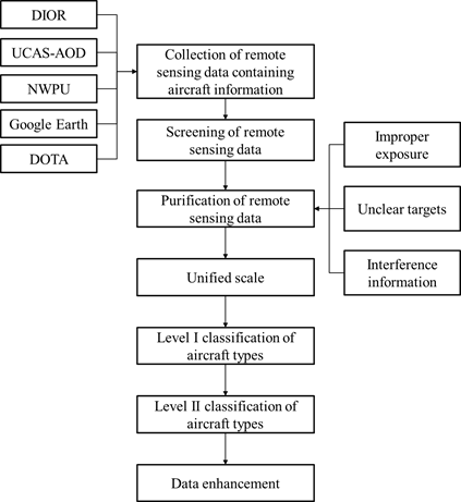 3.2 Data Collection and Processing
The
flowchart of the dataset processing is shown in Figure 1, which includes seven
parts: remote sensing data collection containing aircraft information, screening
of remote sensing data, purification of remote sensing data, unified scale, level I classification of aircraft types, level II
classification of aircraft types, and data augmentation.
3.2.1 Collection of Remote Sensing Data Containing Aircraft Information
 We collect a lot of airport images from public datasets, including
DIOR[4], UCAS_AOD[5], NWPU VHR-10[6-8], DOTA[9-10] and Google Earth. Specifically,
for the Google Earth, we select some airport images around the world such as
Beijing Capital International Airport, Amsterdam Airport, Phoenix
Sky Harbor International Airport and so on. The collected images come from
different sensors, times, seasons, and light so that these data have diversity
within the class.
We collect a lot of airport images from public datasets, including
DIOR[4], UCAS_AOD[5], NWPU VHR-10[6-8], DOTA[9-10] and Google Earth. Specifically,
for the Google Earth, we select some airport images around the world such as
Beijing Capital International Airport, Amsterdam Airport, Phoenix
Sky Harbor International Airport and so on. The collected images come from
different sensors, times, seasons, and light so that these data have diversity
within the class.
3.2.2 Screening of Remote Sensing Data
For
the airport images from public dataset, we combine the category labels to get aircraft
data. For the airport images from Google Earth, we obtain the aircraft target
by employing professionals to annotate the aircraft manually.
3.2.3 Purification of Remote Sensing Data
Four
kinds of problems in data are identified and eliminate.
(1) The interference
information includes stepladder, trucks, personnel, and adjacent aircraft.
(2) Aircraft
background noises include white zebra crossing, bright stripe, and shadows of
surrounding buildings.
(3) The aircraft is
located at the edge.
(4) Bad data with
too strong exposure, weak exposure, fog, and too small target.
3.2.4 Unified Scale
After filtering the remote sensing aircraft data
through human computer interaction, the data size is normalized to 96 pixels ??
96 pixels.
3.2.5 Level I Classification of Aircraft Types
According
to 15 research results and the visual attention mechanism, the aircraft could
be classified to the seven level I types according to the wing and the
propeller: (1) Swept-back wing aircraft; (2) Swept-back aircraft with leading
edge; (3) Forward-swept wing airplane with trailing edge; (4) Delta-wing
aircraft; (5) Flat-wing aircraft; (6) Propeller aircraft; (7) Helicopter.
3.2.6 Level II Classification of Aircraft Types
Four
level I types are classified further and obtains 11 level
II classifications according to engine and color.
(1) The swept-back
wing aircraft: It can be divided into three types
according to the width of wings, the position of engine and the fuselage color.
The swept-back wing aircraft with narrow wings, bright colored airframe (white,
blue, etc.) and engines at empennage is named the swept-back wing aircraft I. The
swept-back wing aircraft with narrow wings, bright color airframe (white, blue,
etc.) and engines under wings is named the swept-back wing aircraft II. The
swept-back wing aircraft with wider wings and dark colored airframe (grey, dark
green, etc.) is named the swept-back wing aircraft III.
(2) Swept-back
aircraft with leading edge: It can be divided into two categories according to
the position of the engine. The engine at the tail is named as swept-back aircraft
with leading edge-I. The engine is not located at the tail and this type of
aircraft is named as the leading-edge swept wing II.
(3) Flat-wing
aircraft. The engine at the tail is named flat-wing aircraft-I. The engine is
not located at the tail and this type of aircraft is named flat-wing
aircraft-II.
(4) The propeller
aircraft: It can be divided into four categories according to the ratio of
propeller to airframe and color. The proportion of smaller propeller and the
fuselage with bright color (white, color, etc.) is named propeller aircraft I.
The proportion of smaller propeller and the fuselage with dark colored airframe
(grey, dark green, etc.) is named propeller aircraft II. The proportion of
larger propeller and bright colored airframe (white, color, etc.) is named
propeller aircraft III. The proportion of larger propeller and dark colored
airframe (grey, dark green, etc.) is named propeller aircraft IV.
3.2.7 Data Augmentation
According to different experimental requirements, the
data for the OPT-Aircraft _v1.0 can be augmented. For example, we can mirror
the data and rotate it by 45??, 90??, 135??, 180??, 270??, etc. The data can be
amplified by 3 to 7 times according to the experimental conditions so that we
can improve the experimental accuracy.
4 Dataset Results and Validation
4.1 Data Composition
The
classification dataset of aircraft types based on remote sensing images
(OPT-aircraft _V1.0) collects a total of 3,954 valid aircraft, which is divided
into 7 level I classifications and 11 level II classifications.
The 7 level I
classifications are: 1. Swept-back wing aircraft, 2. Swept-back aircraft with leading edge, 3. Forward-swept wing aircraft with
trailing edge, 4. Delta-wing aircraft, 5. Flat wing aircraft, 6. Propeller aircraft,
7. Helicopter.
The naming rules of the 11 level II classifications are separated by the decimal
point. The number before the decimal point represents the level I
classifications, and the number after the decimal point represents the level II
classification of the same category. Table 2 shows the details of the specific
classification, the English name of the aircraft types and the corresponding
data folder??s name.
Table 2 Classification Dataset of Aircraft Types
based on Remote Sensing Images (OPT-Aircraft _v1.0)
|
Level I classification
|
Level II classification
|
Number
|
|
1 Swept-back wing aircraft
(1 Swept_back_ wing_aircraft)
|
1.1 Swept-back wing aircraft I (Sp_bk_I)
|
656
|
|
1.2 Swept-back wing aircraft II (Sp_bk_II)
|
201
|
|
1.3 Swept-back wing aircraft III (Sp_bk_III)
|
320
|
|
2 Swept-back aircraft with leading
edge
(2 Leading_edge_ sp_bk_aircraft)
|
2.1 Swept-back aircraft with leading edge I
(Ld_sp_bk_I)
|
104
|
|
2.2 Swept-back aircraft with leading edge II (Ld_sp_bk_II)
|
75
|
|
3 Forward-swept wing airplane with trailing edge
(3 Trailing_edge_ forward_sp_airplane)
|
|
21
|
|
4 Delta-wing aircraft
(4 Delta_aircraft)
|
|
192
|
|
5 Flat-wing aircraft
(5 Flat_wing _aircraft)
|
5.1 Flat-wing aircraft I (5.1 Ft_Eg_I)
|
134
|
|
5.2 Flat-wing aircraft II (5.2 Ft_Eg_II)
|
1,088
|
|
6 Propeller aircraft
(6 Propeller_aircraft)
|
6.1 Propeller aircraft I (6.1 Propeller_airplane_I)
|
104
|
|
6.2 Propeller aircraft II (6.2 Propeller_aircraft_II)
|
414
|
|
6.3 Propeller aircraft III (6.3 Propeller_aircraft_III)
|
242
|
|
6.4 Propeller aircraft IV (6.4 Propeller_aircraft_IV)
|
39
|
|
7 Helicopter
(7 Helicopter)
|
|
4
|
|
A total of 7 level I
classifications
|
There are 11 level II classifications
|
Total 3,594
|
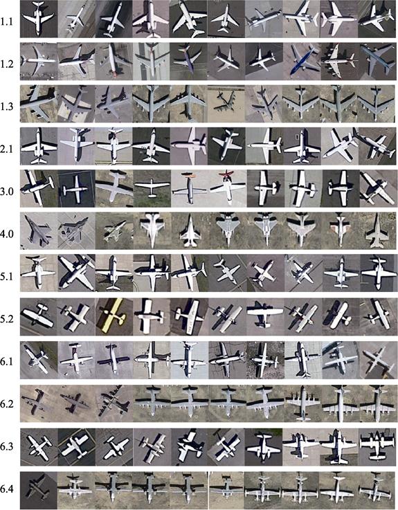
4.2 Data Products
Figure 2 shows the 11 level II classifications in
the dataset of OPT-Aircraft _v1.0. Each row displays 10 images randomly in the
same category.
We used t-SNE[11] algorithm to reduce the dimension of the OPT-Aircraft _v1.0 dataset.
The t-SNE[11] (t-distributed stochastic neighbor embedding) algorithm maps the
sample data points to the probability distribution through affine transformation
so as to make the two probability distributions in high spaces and low
dimensional spaces are as similar as possible. Figure 3 shows the
two-dimensional space representation of the 5 level II classifications (1.3
Swept-back wing aircraft III, 2.2 Swept-back aircraft with leading edge II, 4
Delta-wing aircraft, 5.2 Flat-wing aircraft II, 6.2 Propeller aircraft II) by
using the t-SNE algorithm[11]. The same color represents the same type. The horizontal and
vertical coordinates represent the mapping values of two dimensions in a
low-dimensional space. For these five level II classifications, we can see that
the distance between the same class is small and the
distance between different classes is large. The reduced spaces can be
separated.
Figure
2 Part
of images from the dataset of OPT-Aircraft _v1.0
|
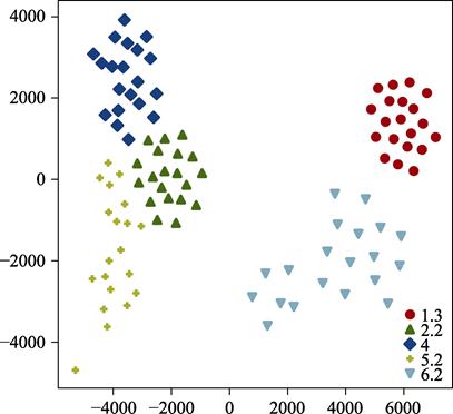
Figure 3 Data visualization of 5 level II classifications (1.3
Swept-back wing aircraft III, 2.2 Swept-back aircraft with leading edge II, 4
Delta-wing aircraft, 5.2 Flat-wing aircraft II, 6.2 Propeller aircraft II) by
using the t-SNE
|
Combining Figure 2 and 3, we can see that each of the 11 level II
classifications has its own characteristics. This method of classification can
cover different aircraft remote sensing data. More importantly, we can
distinguish 11 level II classification further based
on the color, engine position and so on. According to the rule of classification
in 3.2, we use the remote sensing image of the aircraft in TGRS-HRRSD-Dataset[12] to verify. It can be found that we can classify the aircraft of
TGRS-HRRSD-Dataset into 11 level II classification accurately.
Finally, the dataset is stored in .png format with a data size of 69.3 MB.
5 Discussion and Conclusion
In remote sensing
data processing, the fine-grained recognition is still in the early stage. The
shortage of aircraft classification data has difficulties in researching the scientific
issues. This paper solves the above problems. First, the dataset of
OPT-Aircraft _v1.0 is screened aircraft images from public datasets and
high-resolution remote sensing images in Google Earth. Then, we classify the aircraft
images according to the classification criteria. This
classification criteria are according to the wing shape, engines, airframe??s
color and so on. Finally, we divide the remote sensing images of aircraft into 7
level I classifications and 11 level II classifications.
It covers aircraft with different characteristics in the field of remote
sensing and complete a data division criterion.
By using the t-SNE, we can see the
separability of the 11 level II classifications in low dimensional space. This
is helpful to improve the accuracy of fine-grained recognition and
classification of aircraft images. What??s
more, the dataset of OPT-Aircraft _v1.0 is marked with different labels. In the
simulation of remote sensing targets, the generative precision of different
types of aircraft can be improved by using the generative adversarial networks
(GAN).
In order to promote the accuracy of simulation
and recognition in remote sensing scenes, the next task plan to complete the
realistic simulation of remote sensing aircraft and fine-grained recognition based
on OPT aircraft_ V1.0. This is very beneficial to accurately predict the risk
and cost in the stage of load development and identifying specific targets. Of course, the dataset of OPT-Aircraft _v1.0
can also be improved. In the following stage, we can continue to collect and process
more aircraft images according to the classification criteria in this paper. At
the same time, we use the network of GAN to generate the required data to
supplement the dataset of OPT-Aircraft _v1.0 to promote the precision of fine-grained
recognition, which is a process of mutual promotion between them.
Author Contributions
Li, H. W. designed the algorithms of dataset.
Chen, J. Y. and Chen, T. Q. contributed to the data processing and analysis.
Li, H. W. and Chen, J. Y. designed the model and algorithm. Zhang, G., Wang, S.
and Chen, J. Y. verified the data. Chen, J. Y. wrote the data paper.
References
[1] Maji, S., Rahtu, E.,
Kannala, J., et al. Fine-grained
visual classification of aircraft [OL]. arXiv, 2013.
http://arxiv.org/abs/1306.5151.
[2] Chen, J. Y., Li, H. W., Zhang, G., et al. Dataset of identifying aircraft
groups by remote sensing images [J/DB/OL].
Digital Journal of Global Change Data Repository, 2020.
DOI: 10.3974/geodb.2020.03.25.V1.
[3] GCdataPR Editorial
Office. GCdataPR Data Sharing Policy [OL]. DOI:
10.3974/dp.policy.2014.05 (Updated 2017).
[4] Li, L., Xin, X. Z., Zhang, H. L., et al. A method for
estimating hourly photosynthetically active radiation (PAR) in China by
combining geostationary and polar-orbiting satellite data [J]. Remote Sensing of Environment, 2015,
165: 14?C26. DOI: 10.1016/j.rse.2015.03.034.
[5] Zhu, H., Chen, X., Dai, W., et al. Orientation robust object
detection in aerial images using deep convolutional neural network [C]. IEEE
International Conference on Image Processing (ICIP), 2015, DOI: 10.1109/ICIP.2015.7351502.
[6] Cheng, G., Han, J., Zhou, P., et al. Multi-class geospatial object
detection and geographic image classification based on collection of part
detectors [J]. ISPRS
Journal of Photogrammetry and Remote Sensing, 2014, 98: 119?C132.
DOI: 10.1016/j.isprsjprs.2014.10.002.
[7] Cheng, G., Han, J. A survey on object
detection in optical remote sensing images [J]. ISPRS Journal of Photogrammetry and Remote
Sensing, 2016, 117: 11?C28. DOI: 10.1016/j.isprsjprs.2016.03.014.
[8] Cheng, G., Zhou, P., Han, J. Learning rotation-invariant
convolutional neural networks for object detection in vhr optical remote
sensing images [J]. IEEE Transactions on
Geoscience and Remote Sensing, 2016, 54(12): 7405?C7415. DOI: 10.1109/TGRS.2016.2601622.
[9] Xia, G. S., Bai, X., Ding, J., et al. DOTA: a large-scale dataset for
object detection in aerial images [OL]. arXiv, 2019.
http://arxiv.org/abs/1711.10398.
[10] Ding, J., Xue, N., Long, Y., et al. Learning RoI transformer for detecting oriented objects in
aerial images [OL]. arXiv, 2018.
http://arxiv.org/abs/1812.00155.
[11] Der Maaten, L. V., Hinton, G. E. Visualizing data using
T-SNE [J]. Journal of Machine Learning
Research, 2008, 9: 2579?C2625.
[12] Zhang, Y., Yuan, Y., Feng, Y., et al. Hierarchical and robust convolutional neural network for
very high-resolution remote sensing object detection [J]. IEEE Transactions on Geoscience and Remote Sensing, 2019, 57(8):
5535?C5548. DOI: 10.1109/TGRS.2019.2900302.