GIES
Case Study on Huinan Rice Permanent Basic Farmland
WANG Ping1 HE Jiwei2 TIAN Chengyi3 WANG Yongfu4 ZHAO Lili5 WANG Lan6 LIANG Lili7 WANG Sen8 PAN Xiaoming9 GAO Zhenghang10 LI Peng11 XUE Wei12 LI Jianing13 ZHANG Di14 MA Chengwei15 TONG Lishuai16 SUN Xuejun17 ZHANG Chongjun3 ZOU Liping3 MENG Xiangjun18* MENG Weiren19 AI Zhiguo20 NI Xuejian21 ZHANG Jianxiu22 GUO Hongyi23 SHEN Baohua24 SHI Yanhui25 CHEN Yan26 ZHAO Ling26* ZHAO Guiyu26 WANG Hongqiao26 YAN Yunxian26 CHE Xiaocui26 TIAN Lu26 SUN Xu26 LAI Shiwei26 LI Yuhan1 ZHANG Jinzi1
1. Northeast Normal University,
Changchun 130024,
China;
2.
People’s Government of Huinan County,
Huinan
135100, China;
3.
Huinan County Market Supervision and Administration Bureau,
Huinan
135199, China;
4.
People’s Government of Chaoyang Town, Huinan 135100,
China;
5.
People’s Government of Huinan Town, Huinan 135102,
China;
6. People’s Government of Fumin Town, Huinan 135115, China; 7. People’s Government of Yangzishao
Town, Huinan 135122, China; 8. People’s Government of Shidaohe Town, Huinan 135108, China; 9. People’s Government of Shansonggang
Town, Huinan 135114, China; 10. People’s Government of Huifacheng
Town, Huinan 135125,
China;
11.
People’s Government of Jinchuan Town, Huinan 135117,
China;
12.
People’s Government of Loujie Township, Huinan 135119,
China;
13.
People’s Government of Qingyang Town, Huinan 135107,
China;
14.
People’s Government of Tuanlin Town, Huinan 135124,
China;
15.
Dongfeng Sub-district Office, Huinan 135100,
China;
16.
Xifeng Sub-district Office, Huinan 135100,
China;
17.
Chaohui Sub-district Office, Huinan 135100,
China;
18.
Jilin University of Finance and Economics,
Changchun
130117, China;
19.
Jilin Academy of Agricultural Sciences (Northeast Innovation Center for
Agricultural Science and Technology), Changchun 130033,
China; 20. Huinan County Agricultural Technology Extension
Station, Huinan 135199,
China;
21.
Jilin Nishi Agricultural Technology Co., Ltd., Huinan 135122,
China;
22.
Jilin Province Huinong Japonica Rice Science Technology Development Co., Ltd.,
Huinan
135102, China;
23.
Jilin Sanhe Farm Co., Ltd., Huinan 135199,
China;
24.
Jilin Changxing Grain and Food Co., Ltd.,
Huinan
135119, China;
25.
Guanghui Village, Huifacheng Town,
Huinan
135125, China;
26. Jilin
Agricultural University, Changchun 130118,
China
Abstract:
Huinan County is under the jurisdiction of Tonghua City, Jilin Province, with a total area of 2,275 km2, has 3 subdistricts, 10 towns, and
1 ethnic township. In 2023, Huinan County had a population of 214,100 and a GDP
of 10.269 billion CNY. It is charactered by a temperate
continental monsoon climate, volcanic ash-based soils, and irrigation supplied
by pure mountain spring water, endowing it with distinctive habitat
superiorities. It is also recognized as a permanent basic farmland area in
Northeast China. Huinan rice varieties are high-quality rice varieties
developed under local suitable climate and soil conditions, featuring rich
trace elements, with pollutant concentration far below national standard
limits. Benefiting from pristine water sources, fertile soil and unique
climatic conditions, Huinan rice exhibits a long growth cycle and large diurnal
temperature variation, which facilitates sufficient natural nutrient
accumulation and contributes to its reputation as a naturally healthy and
premium-quality ecological rice product. A complete industrial chain for rice
cultivation and multi-stakeholder coordinated brand development mechanisms have
been well established in Huinan County. This study scientifically verifies the
quality advantages of Huinan rice and their correlation with local ecological
conditions, thereby providing practical support for quality improvement and
efficiency enhancement of the local rice industry. The dataset consists of
data: case area boundary, physical geographic data, product characteristic
data, operation and management data, socioeconomic and historical-cultural
data, photographic materials. The dataset is archived in .shp, .docx, .tif,
.jpg, and .xlsx data formats, and consists of 62 data files with data size of
73.0 MB (compressed into 1 file with 20.5 MB).
Keywords: Changbai Mountain; Huinan County; rice;
permanent basic farmland; volcanic ash substrate; GIES; Case 37
DOI: https://doi.org/10.3974/geodp.2026.03.10
Dataset Availability Statement:
The dataset supporting this paper
was published and is accessible through the Digital Journal of Global Change Data Repository
at: https://doi.org/10.3974/geodb.2026.04.02.V1.
1 Introduction
With the continuously growing pursuit of living
standards and rising demand for high-quality agricultural products in the new
era, premium agricultural commodities have become an indispensable part of
people’s daily life. To satisfy the urgent market demand for superior
agricultural products, high-quality geographical indication products have
emerged rapidly as the times require[1]. The Jilin Provincial
Government have attached great importance to the ecological conservation and
rational development of the Changbai Mt. region. With ecological conservation
and high-quality development of the Changbai Mt. as the core orientation for
the development of local characteristic resource-based food industries and the
construction of Jilin regional brand series, a series of key development
initiatives have been implemented successively.
|
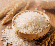
Figure 1
Huinan County rice
|
Located
in Tonghua City, Jilin Province, Huinan County lies at the western foot of the
Changbai Mt., serving as a transitional zone between the Changbai Mt. Range and
the Songliao Plain, and is characterized as a hilly and semi-mountainous area.
The unique soil parent material formed by volcanic ash lays superior natural
foundations for rice cultivation (Figure 1). In the context of the development
and protection projects of geographical indication products in the Changbai Mt.
region mentioned above, this paper further explores the cultivation pathways of
geographical indications products, so as to provide a scientific basis and
practical references for the high-quality development of regional
characteristic agricultural products.
2 Metadata of the Dataset
The information including the name, authors, geographical region,
year of the data, data files, data publication and sharing service platform,
and data sharing policy of GIES case dataset on Huinan rice permanent basic farmland[2]
is shown in Table 1.
Table 1 Metadata summary of GIES case dataset on Huinan rice
permanent basic farmland
|
Item
|
Description
|
|
Dataset
full name
|
GIES case
dataset on Huinan rice permanent basic farmland
|
|
Dataset short
name
|
HuinanRiceCase37
|
|
Authors
|
Wang, P., School of Geographical Sciences,
Northeast Normal University, wangp666@nenu.edu.cn
|
|
He, J. W., People’s
Government of Huinan County, zhanghao1996@163.com
|
|
Tian, C. Y., Huinan County Market
Supervision and Administration Bureau, 1143866329@qq.com
|
|
Wang, Y. F.,
People’s Government of Chaoyang Town, Huinan, 1508042315@qq.com
|
|
Zhao, L. L., People’s Government of Huinan
Town, Huinan, huinanzhen2415@163.com
|
|
Wang, L., People’s Government of Fumin
Town, Huinan, umin8752472@163.comf
|
|
Liang, L. L., People’s Government of Yangzishao
Town, Huinan, 451086176@qq.com
|
|
Wang, S., People’s Government of Shidaohe
Town, Huinan, 16643509976@163.com
|
|
Pan, X. M., People’s Government of Shansonggang
Town, Huinan, 19169178302@qq.com
|
|
Gao, Z. H., People’s Government of Huifacheng
Town, Huinan, 1835215950@qq.com
|
|
Li, P., People’s Government of Jinchuan
Town, Huinan, jinchuan8862003@163.com
|
|
Xue, W., People’s Government of Loujie
Township, Huinan, 18743541922@163.com
|
|
Li, J. N., People’s Government of Qingyang
Town, Huinan, 3516139302@qq.com
|
|
Zhang, D., People’s Government of Tuanlin
Town, Huinan, 18243568052@163.com
|
|
Ma, C. W., Dongfeng Sub-district Office,
Huinan, 1169130040@qq.com
|
|
Tong, L. S., Xifeng Sub-district Office, Huinan, xifengjiedaobangongshi@163.com
|
|
Sun, X. J., Chaohui Sub-district Office,
Huinan, 1169089796@qq.com
|
|
Zhang, C. J., Huinan County Market
Supervision and Administration Bureau, 2682806468@qq.com
|
|
Zou, L. P., Huinan County Market
Supervision and Administration Bureau, zouliping1125@163.com
|
|
Meng, X. J., Jilin University of Finance
and Economics, mengxj617@163.com
|
|
Meng, W. R., Jilin Academy of Agricultural
Sciences, mwr1104@126.com
|
|
Ai, Z. G., Huinan County Agricultural
Technology Extension Station, azg777@163.com
|
|
Ni, X. J., Jilin Nishi Agricultural
Technology Co., Ltd., 862610767@qq.com
|
|
Zhang, J. X., Jilin Province Huinong
Japonica Rice Science Technology Development Co., Ltd., 961506291@qq.com
|
|
Guo, H. Y., Jilin Sanhe Farm Co. Ltd.,
303700618@qq.com
|
|
Shen, B. H., Jilin Changxing Grain and
Food Co. Ltd., shenbaohua@126.com
|
|
Shi, Y. H., Guanghui
Village, Huifacheng Town, Huinan County, Jilin Province, 1438746701@qq.com
|
|
Chen, Y., Jilin Agricultural University,
602563840@qq.com
|
|
Zhao, L., Jilin Agricultural University,
zhaol@jlau.edu.cn
|
|
Zhao, G. Y., Jilin Agricultural
University, zhaoguiyu@jlau.edu.cn
|
|
Wang, H. Q., Jilin Agricultural
University, wanghq921@126.com
|
|
Yan, Y. X., Jilin Agricultural University,
yanyunxian@126.com
|
|
Che, X. C., Jilin Agricultural University,
xiaocuic@jlau.edu.cn
|
|
Tian, L., Jilin Agricultural University,
tianlu-1982@163.com
|
|
Sun, X., Jilin Agricultural University,
389099907@qq.com
|
|
Lai, S. W., Jilin Agricultural University,
1084343694@qq.com
|
|
Geographical
region
|
Huinan County, Tonghua City, Jilin Province
|
|
Year
|
2000–2024
|
|
Data
format
|
.shp, .tif, .xlsx, .docx, .jpg
|
|
Data
size
|
73.0 MB
|
|
Data files
|
Case area boundary, physical geographic data, rice
product characteristic data, management data, photographs and images
|
|
Foundation
|
Jilin Provincial Administration for Market Regulation
(2025)
|
|
Data publisher
|
Global Change Research Data Publishing & Repository, http://www.geodoi.ac.cn
|
|
Address
|
No. 11A,
Datun Road, Chaoyang District, Beijing 100101
|
(To be continued on the next page)
(Continued)
|
Item
|
Description
|
|
Data sharing
policy
|
(1) Data are openly available and
can be free downloaded via the Internet; (2) End users are encouraged to use Data
subject to citation; (3) Users, who are by definition also value-added
service providers, are welcome to redistribute Data subject to written permission from
the GCdataPR Editorial Office and the issuance of a Data
redistribution license; and (4) If Data are used to compile new
datasets, the “ten percent principle” should be followed such that Data
records utilized should not surpass 10% of the new dataset contents, while
sources should be clearly noted in suitable places in the new dataset[3]
|
|
Communication
and searchable
system
|
DOI, CSTR, Crossref, DCI, CSCD, CNKI, SciEngine,
WDS, GEOSS, PubScholar, CKRSC
|
3 Case Data Development
3.1 Case Area
|
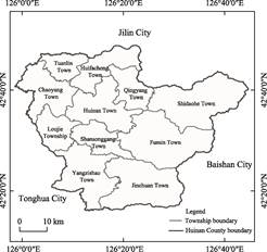
Figure 2 Map of the geo-location and administrative
divisions of Huinan County
|
Huinan County is situated in the northern part of Tonghua
City, at the western foothills of the
Changbai Mt. (Figure 2). It spans
from 42°16′19″N to 42°49′15″N and 125°58′49″E to 126°44′39″E. The county
administers 3 subdistricts, 10 towns, and 1 ethnic township, with a total area
of 2,275 km2. In 2023, Huinan County had a population of 214,100 and
a GDP of 10.269 billion CNY, the rice planting area reached 32,536 ha, with a
total rice output of 25.36×10⁴ t.
3.2 Ecological and
Environmental Data
3.2.1 Topography
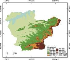
Huinan County is situated at the western
foothills of the Changbai Mt. and characterized as a semi-mountainous area.
Ancient volcanic activities had shaped its distinctive topographic
pattern with terrain gradually descending from southeast to northwest forming 4
landform types: low mountains, hills, tablelands and river valley plains. Based
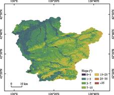
on the analysis of elevation and slope in Huinan County (Figure 3), the
southeastern part is dominated by low mountains with an average elevation
ranging from 500 m to 700 m. The central area is hilly and semi-mountainous,
where the elevation is generally between 400 m and 500 m. Mountains and hills
account for 67.9% of the total county area, forming a natural ecological barrier
for the region[4]. River valley plains are distributed along rivers
in the western and northwestern parts, with an altitude of 300–400 m and a
slope gradient less than 2° (Figure 4). The open and flat terrain provides
extensive arable land suitable for irrigation and large-scale rice cultivation.
These geographic advantages have strongly supported the scaled development of
volcanic ash soil substrate-based rice cultivation in Huinan County.
3.2.2 Land Use and Vegetation Cover
The total cultivated land
area of Huinan County is 87,605.35 ha. Among all administrative towns,
Yangzishao, Chaoyang, Huinan and Huifacheng possess relatively large cultivated
land areas, collectively accounting for 48.02% of the county’s total cultivated
land. Rice cultivation is highly concentrated
on irrigated farmland and paddy fields distributed across river valley plains. These
areas are characterized by gentle terrain and convenient water
|
|
|
|
Figure 3 Elevation classification
map of Huinan County
|
Figure 4 Slope classification
map of Huinan County
|
irrigation, serving as the core base for
large-scale production of high-quality rice. In contrast, the low mountains and hilly areas with steeper slopes are mainly
covered by forest and dry farmland, with only limited rice cultivation. As
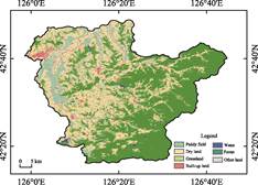
shown in Figure 5, cultivated land patches are distributed in a belt-like
pattern along river systems, which are closely associated to water bodies and irrigation
infrastructures. This forms a spatial pattern integrating water systems and
farmlands, providing inherent natural irrigation conditions for rice
cultivation.
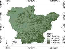
Based on Landsat-5 and Landsat-9 data
,the Normalized Difference Vegetation Index (NDVI) for the case area was
calculated (Figure 6). The results show that the overall vegetation coverage in
the case area remains at relatively high level overall, with favorable
vegetation conditions during the rice growing season, which preliminarily
reflects the supporting effect of the superior ecological habitat on crop
growth. Further pixel-scale
linear trend analysis of NDVI medians from 2000 to 2025 reveals that
statistically significant greening pixels (p<0.05) are widely and
persistently distributed across the county, quantitatively confirming that the
regional ecological environment has been in a stable and improving long-term
trajectory. Significant greening pixels are mainly concentrated in paddy field
areas within river valley plains, exhibiting a synergistic optimization pattern
of “better land becomes even better”, which strongly verifies the stable
support of superior habitat conditions for rice growth. Benefiting from
continuously improved vegetation coverage, abundant accumulation of soil
minerals and clean irrigation water, local rice exhibits more sufficient
nutrient accumulation, providing a solid and unique ecological guarantee for
producing high-quality rice with excellent eating
quality and stable product characteristics.
|
|
|
|
Figure 5 Land use map of Huinan County
|
Figure
6 NDVI change rates map of Huinan County
(2000–2025)
|
3.2.3
Climatic
Conditions
Huinan
County features a temperate continental monsoon climate, which is further moderated
by its transitional hilly and semi-mountainous terrain, resulting in four
distinct seasons. It is windy and dry in spring, hot and rainy in summer, mild
and cool in autumn, and long and cold in winter[5,6]. According to
data from Huinan Meteorological Bureau, the regional mean annual temperature was
5.39 ℃ during 2005–2024, with an annual frost-free period of 148 d and a
mean annual sunshine duration of 2,410.41 h. Precipitation is mainly
concentrated from June to August, with an average annual total precipitation of
745.96 mm. The prevailing winds are southwest wind and westerly wind; wind
speeds peak in spring and drop to the
minimum in summer. The county averages 13 gale days per year with a mean wind
speed of 2.19 m/s and an annual accumulated temperature exceeding 2,800 ℃
(Figure 7).
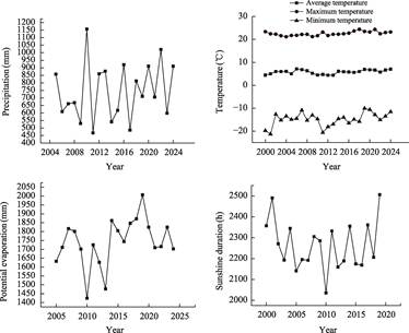
Figure 7 Climate characteristics change of Huinan
County
As a typical
thermophilic and water-demanding
crop, rice has periodic demands for temperature and precipitation in producing
areas. The climate of the case area is characterized by high temperature and
abundant rainfall in summer, with a pronounced rain-heat synchrony that is
highly consistent with the rice growth cycle and conducive to rice development.
Statistical data indicate that the mean temperature from May to September
remains above 14.5 ℃, fully meeting the thermal requirements for all critical
growth stages of rice, including transplanting, tillering, heading and grain
filling. The mean temperature of the hottest month (July) is merely
22.5 ℃, which coincides with the heading and flowering stage of rice. Such
temperature conditions facilitate pollination and grain setting, and avoid the
widespread “high-temperature forced
ripening” phenomenon in other rice cultivating regions, thereby guaranteeing
the stable production of high-quality japonica rice.
Meanwhile,
affected by the continental monsoon climate, the region exhibits a large
diurnal temperature range in summer, which benefits the accumulation of dry
matter and flavor substances in rice. Sufficient sunshine, prominent day-night
temperature variation and well-matched precipitation supply jointly optimize
the growth environment of rice. The rational combination of light, heat and
water resources extends the grain filling duration, restrains pest and disease
outbreaks, and maintains the natural quality of rice, providing solid climatic
support for the formation of high-quality rice.
3.2.4 Water Conditions
Surface water resources in Huinan
County are primarily recharged by rainfall, and their seasonal variation is
highly correlated with the temporal distribution of precipitation. In terms of
hydrological regimes, the annual cycle can be divided into 3 seasons, which are
spring flood season, dry season and main flood season. Meanwhile in view of
flow conditions, it can be divided into open-water period and ice-covered
period. Precipitation generally declines in winter and rivers froze over.
During this period, surface water is mainly supplemented by groundwater, resulting
in the first dry season. Surface water volume in this period accounts for
5%–10% of the annual total. Snowpack and river ice accumulated in the watershed
during winter melt in March and April as temperatures rise, giving rise to spring floods, which contribute
10%–20% of the annual surface water resources. Scanty rainfall after spring
floods leads to the pre-flood dry period. The main flood season starts
in June, with concentrated rainfall occurring in July and August. Surface water
runoff from June to September makes up approximately 70% of the annual volume[4].
Serving as the core water supply guarantee for local rice irrigation,
reservoirs capture and store natural rainwater during flood seasons to fully
meet water demands in critical rice growth stages such as tillering stage and
grain-filling stage during dry periods. Major storage reservoirs in Huinan County
include Hailong Reservoir, Shidaohe Reservoir, Dayishan Reservoir and
Xiaoyishan Reservoir. Furthermore, mountain spring water from Sanjiaolongwan is
diverted to reservoirs adjacent to rice cultivation areas including Xiaoyishan
Reservoir. The diverted spring water is exposed to solar warming to increase its
temperature before being applied to paddy field irrigation.
 Considering the physical geographical conditions of the case area and
the fact that reservoirs serve as the main irrigation water sources, the
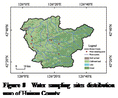
irrigation water samples were collected to further explore the superior habitat
advantages (Figure 8). A total of 11 water samples were collected and analyzed
by the Institute of Agricultural Quality Standards and Testing Technology,
Jilin Academy of Agricultural Sciences (Northeast Innovation Center of Chinese
Agricultural Science and Technology). The test results (Table 2) indicate that
the local irrigation water is weakly alkaline. Electrical conductivity, an
indicator reflecting the total concentration of dissolved salts in water,
ranged from 105 to 317 μS/cm with a mean
value of 178.09 μS/cm, representing an overall low-salinity level that
avoids soil salinization. In addition, the unique mountain spring water is enriched
with a variety of trace elements, particularly
magnesium and calcium, both of which exhibit notably high concentrations
and may contribute positively to habitat quality.
Considering the physical geographical conditions of the case area and
the fact that reservoirs serve as the main irrigation water sources, the
irrigation water samples were collected to further explore the superior habitat
advantages (Figure 8). A total of 11 water samples were collected and analyzed
by the Institute of Agricultural Quality Standards and Testing Technology,
Jilin Academy of Agricultural Sciences (Northeast Innovation Center of Chinese
Agricultural Science and Technology). The test results (Table 2) indicate that
the local irrigation water is weakly alkaline. Electrical conductivity, an
indicator reflecting the total concentration of dissolved salts in water,
ranged from 105 to 317 μS/cm with a mean
value of 178.09 μS/cm, representing an overall low-salinity level that
avoids soil salinization. In addition, the unique mountain spring water is enriched
with a variety of trace elements, particularly
magnesium and calcium, both of which exhibit notably high concentrations
and may contribute positively to habitat quality.
The concentrations of heavy metals
and metalloids in all water samples were far lower than the threshold values
specified in the national Standard for irrigation water quality (GB 5084—2021)[7]
(Table 3). Notably, cadmium was not detected in all tested samples. As
one of the heavy metals most prone to enrichment in rice grains and posing
severe hazards to human health, especially to kidneys and bones, the
non-detection of cadmium fundamentally eliminates potential cadmium
contamination risks of rice cultivated on volcanic ash soil, which constitutes
an essential safety advantage of local rice products. These findings fully
guarantee the safety of irrigation water and lay a solid foundation for the
quality and safety of rice.
In conclusion, the case area boasts
superior water quality with extremely low pollutant concentrations. It not only
reflects the well-preserved ecological environment of Huinan County, but also
supplies abundant trace elements for rice growth to further improve the
nutritional quality of rice. It serves as one of the core cornerstones for
building the brand image of volcanic ash-cultivated rice which emphasizes green
production, organic attributes, food safety and health benefits.
Table 2 Statistical testing results of trace
element concentration (nutrient) in water of Huinan County
|
Sample
|
pH
|
Total
water-soluble salt content (electrical conductivity at 25 ℃) (μS/cm)
|
Mg
(μg/L)
|
P
(μg/L)
|
K
(μg/L)
|
Ca
(μg/L)
|
Mo (μg/L)
|
Mn (μg/L)
|
Fe
(μg/L)
|
|
W (3)
|
7.27
|
198
|
5,948
|
42.4
|
1,221
|
17,996
|
0.91
|
0.572
|
109
|
|
W (4)
|
7.12
|
173
|
4,942
|
23.6
|
1,646
|
16,266
|
0.58
|
0.506
|
45.8
|
|
W (5)
|
9.15
|
187
|
10,570
|
29.1
|
1,355
|
11,025
|
1.12
|
1.40
|
28.7
|
|
W (11)
|
6.88
|
169
|
5,754
|
45.8
|
1,066
|
15,922
|
1.16
|
1.06
|
85.5
|
|
W (12)
|
7.02
|
153
|
4,896
|
81.3
|
922
|
14,176
|
0.70
|
8.92
|
636
|
|
W (13)
|
7.14
|
127
|
4,576
|
59.9
|
934
|
9,390
|
0.45
|
1.63
|
128
|
|
W (14)
|
6.97
|
105
|
3,445
|
31.3
|
659
|
11,799
|
0.46
|
1.77
|
224
|
|
W (15)
|
7.05
|
190
|
6,492
|
32.2
|
1,365
|
23,124
|
3.04
|
2.07
|
65.7
|
|
W (16)
|
7.03
|
226
|
6,196
|
76.6
|
479
|
26,357
|
0.89
|
1.40
|
142
|
|
W (17)
|
7.33
|
317
|
8,599
|
82.7
|
2,245
|
27,563
|
1.86
|
4.22
|
462
|
|
W (18)
|
7.35
|
114
|
3,414
|
66.2
|
1,001
|
9,744
|
0.52
|
4.07
|
815
|
|
Average value
|
7.30
|
178.09
|
5,893.81
|
51.91
|
1,172.09
|
16,669.27
|
1.06
|
2.51
|
249.24
|
Note: Water samples in this study
were collected in multiple batches. Each batch was numbered independently
according to the sampling time, resulting in discontinuous serial numbers. This
numbering method exerts no influence on statistical data analysis and the
reliability of research conclusions.
Table
3 Statistical
testing results of water heavy metal contents in Huinan County Unit:
μg/L
|
Sample
|
Cr
|
Ni
|
Cu
|
As
|
Zn
|
Se
|
Cd
|
Hg
|
Pb
|
|
W (3)
|
0.179
|
1.02
|
0.86
|
ND
|
1.15
|
0.113
|
ND
|
0.161
|
0.074
|
|
W (4)
|
0.053
|
0.45
|
0.77
|
ND
|
0.84
|
0.175
|
ND
|
0.123
|
ND
|
|
W (5)
|
0.109
|
0.59
|
1.03
|
ND
|
1.45
|
0.113
|
ND
|
0.125
|
ND
|
|
W (11)
|
0.092
|
1.14
|
1.10
|
ND
|
1.81
|
0.287
|
ND
|
0.111
|
0.008
|
|
W (12)
|
1.13
|
1.51
|
1.96
|
ND
|
0.89
|
0.983
|
ND
|
0.107
|
0.265
|
|
W (13)
|
0.300
|
0.91
|
0.97
|
ND
|
0.32
|
0.150
|
ND
|
0.097
|
0.005
|
|
W (14)
|
0.289
|
0.82
|
1.35
|
ND
|
0.96
|
0.335
|
ND
|
0.097
|
0.065
|
|
W (15)
|
0.373
|
0.76
|
1.68
|
ND
|
1.51
|
0.222
|
ND
|
0.097
|
ND
|
|
W (16)
|
0.165
|
0.92
|
1.20
|
ND
|
1.35
|
0.149
|
ND
|
0.093
|
0.023
|
|
W (17)
|
0.898
|
2.29
|
3.37
|
0.669
|
1.88
|
0.806
|
ND
|
0.095
|
0.445
|
|
W (18)
|
1.03
|
2.07
|
2.27
|
0.856
|
1.47
|
0.754
|
ND
|
0.091
|
0.632
|
|
Average value
|
0.42
|
1.13
|
1.50
|
0.76
|
1.23
|
0.37
|
ND
|
0.11
|
0.19
|
|
Limits[7]
|
≤100
|
≤200
|
≤500
|
≤2,000
|
≤50
|
≤20
|
≤10
|
≤1
|
≤200
|
Note: ND indicates Not Detected.
3.2.5 Soil Conditions
Located in the volcanic belt at the
western foot of the Changbai Mt., Huinan County is dominated by
volcanic ash soils which exhibit the typical characteristics of the
northeastern China black soil region. In terms of physical properties, volcanic
ash soils are characterized by a loose texture, high porosity, favorable
permeability and air permeability, which facilitate the extension and
respiration of rice root systems as well as the efficient absorption of water
and nutrients. In terms of chemical composition, weathered volcanic ejecta
release abundant minerals and trace elements. Meanwhile, the overlying black
soil and humus layers supply sufficient organic matter and basic nutrients
(nitrogen, phosphorus, potassium, etc.). Consequently, the local soil possesses
excellent water and fertilizer retention capacity as well as desirable aeration
performance. Particularly distinctive are the stone plate lands formed by
solidified volcanic lava, which are covered by fertile soil of 10– 30
cm thickness formed through thousands of years of weathering and humus
accumulation with extremely high mineral content. Given the low heat capacity
of stone plates, large diurnal temperature differences occur, which further
promote nutrient accumulation in the rice during the grain-filling stage. In
addition, various paddy soil types are distributed across the region, such as
albic paddy soil, alluvial paddy soil and peat soil, providing diverse and
fertile conditions for rice growth.
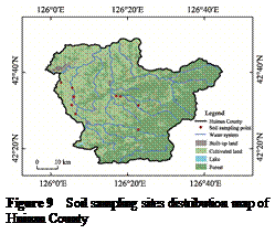 To further explore the soil characteristics of the case area,
surface soil samples were collected from different towns and townships, and the
mineral element concentrations of these samples were determined by the
Institute of Jilin Academy of Agricultural Sciences (Northeast Innovation
Center for Agricultural Science and Technology of China). The spatial
distribution of sampling sites is shown in Figure 9. The magnesium
concentration in soil samples ranged from 6,509 mg/kg to 21,197 mg/kg, with a
mean value of 9,804.33 mg/kg. As an
essential element for photosynthesis in rice, magnesium directly affects
photosynthetic efficiency and nutrient
metabolism, and plays a vital role in yield formation and quality improvement.
The soil calcium concentration varied from 3,127 mg/kg to 20,273 mg/kg,
averaging a relatively high 7,037.44 mg/kg. During rice growth, calcium
contributes greatly to maintaining stable cell structure, balancing nutrient
uptake and enhancing stress and disease resistance of rice plants. In summary,
the unique volcanic ash-derived soil in Huinan County is rich in essential
secondary elements such as magnesium and calcium, which create superior edaphic
conditions for local rice cultivation. In addition, the soil in the case area
is also abundant in other trace elements (Table 4).
To further explore the soil characteristics of the case area,
surface soil samples were collected from different towns and townships, and the
mineral element concentrations of these samples were determined by the
Institute of Jilin Academy of Agricultural Sciences (Northeast Innovation
Center for Agricultural Science and Technology of China). The spatial
distribution of sampling sites is shown in Figure 9. The magnesium
concentration in soil samples ranged from 6,509 mg/kg to 21,197 mg/kg, with a
mean value of 9,804.33 mg/kg. As an
essential element for photosynthesis in rice, magnesium directly affects
photosynthetic efficiency and nutrient
metabolism, and plays a vital role in yield formation and quality improvement.
The soil calcium concentration varied from 3,127 mg/kg to 20,273 mg/kg,
averaging a relatively high 7,037.44 mg/kg. During rice growth, calcium
contributes greatly to maintaining stable cell structure, balancing nutrient
uptake and enhancing stress and disease resistance of rice plants. In summary,
the unique volcanic ash-derived soil in Huinan County is rich in essential
secondary elements such as magnesium and calcium, which create superior edaphic
conditions for local rice cultivation. In addition, the soil in the case area
is also abundant in other trace elements (Table 4).
Table 4 Statistical
testing results of soil nutrient in Huinan County
|
Sample
|
pH
|
OM (g/kg)
|
TN (g/kg)
|
TP (g/kg)
|
TK (g/kg)
|
Mg (mg/kg)
|
Ca (mg/kg)
|
Mn (mg/kg)
|
Fe (mg/kg)
|
|
S (1)
|
5.54
|
39.20
|
1.74
|
0.61
|
21.59
|
8,088
|
5,951
|
317
|
30,499
|
|
S (2)
|
6.24
|
29.10
|
2.86
|
1.45
|
17.00
|
9,522
|
3,867
|
511
|
54,864
|
|
S (11)
|
6.26
|
16.80
|
1.27
|
0.64
|
20.48
|
7,481
|
4,261
|
477
|
30,410
|
|
S (12)
|
5.75
|
30.50
|
1.72
|
1.29
|
17.33
|
21,197
|
20,273
|
1,423
|
63,584
|
|
S (14)
|
5.48
|
45.10
|
1.41
|
0.9
|
21.02
|
11,774
|
11,552
|
918
|
39,710
|
|
S (15)
|
5.91
|
33.60
|
2.06
|
0.89
|
21.55
|
7,356
|
3,710
|
529
|
33,159
|
|
S (16)
|
5.56
|
24.30
|
3.12
|
0.93
|
18.59
|
9,434
|
6,295
|
641
|
37,511
|
|
S (17)
|
5.57
|
16.90
|
1.51
|
0.71
|
20.55
|
6,878
|
3,127
|
646
|
32,163
|
|
S (18)
|
5.91
|
23.80
|
2.04
|
0.7481
|
20.17
|
6,509
|
4,301
|
468
|
30,652
|
|
Average value
|
5.80
|
28.81
|
1.97
|
0.91
|
19.81
|
9,804.33
|
7,037.44
|
658.89
|
39,172.44
|
Note: Soil samples in this study
were collected in multiple batches. Each batch was numbered independently
according to the sampling time, resulting in discontinuous serial numbers. This
numbering method exerts no influence on statistical data analysis and the
reliability of research conclusions.
The iron concentration ranges from 30,410 mg/kg to 63,584 mg/kg,
with an average of 39,172.44 mg/kg; manganese, from 317 mg/kg to
1,423 mg/kg, averaging 658.89 mg/kg; zinc, from 72.7 mg/kg to 125 mg/kg,
averaging 99.248 mg/kg. Though rice requires these trace elements in small
quantities, their deficiency will cause distinct physiological disorders and
impair rice yield and grain quality. The abundant reserves of various trace
elements in the soil of Huinan County further highlight its superior edaphic
conditions for rice cultivation.
The concentrations of 8 soil
pollution elements in the case area, including chromium, nickel, copper, zinc,
arsenic, cadmium, mercury and lead, are all far below the risk screening values
set in Soil environmental quality risk control standard for soil
contamination of agricultural land (Trial) (GB 15618—2018)[8] (Table
5). The test results demonstrate that the soil in the case area is not
contaminated, providing a fundamental basis for the production of safe and
high-quality rice grown on volcanic ash soils.
Table
5 Statistical
testing results of soil heavy metal content in Huinan County Unit: mg/kg
|
Sample
|
Cr
|
Ni
|
Cu
|
Zn
|
As
|
Cd
|
Hg
|
Pb
|
|
S (1)
|
206.4
|
37.8
|
22.6
|
78
|
6.78
|
0.271
|
0.0398
|
22.5
|
|
S (2)
|
157.3
|
52.5
|
28.6
|
125
|
6.71
|
0.313
|
0.0356
|
21.4
|
|
S (11)
|
72.8
|
28.0
|
21.6
|
72.7
|
8.33
|
0.241
|
0.0345
|
23.8
|
|
S (12)
|
101.0
|
34.9
|
39.9
|
125
|
6.70
|
0.345
|
0.028
|
18.3
|
|
S (14)
|
243.4
|
42.6
|
25.9
|
95.8
|
8.67
|
0.278
|
0.0438
|
25.4
|
|
S (15)
|
128.5
|
32.2
|
23.7
|
88.6
|
7.35
|
0.288
|
0.0432
|
26.0
|
|
S (16)
|
89.6
|
41.8
|
26.7
|
106
|
8.22
|
0.320
|
0.0357
|
26.8
|
|
S (17)
|
93.7
|
28.3
|
23.7
|
82.5
|
10.5
|
0.241
|
0.0398
|
30.6
|
|
S (18)
|
138.8
|
31.0
|
25.1
|
79.2
|
9.98
|
0.226
|
0.0412
|
30.4
|
|
Average value
|
136.83
|
41.60
|
26.42
|
94.76
|
8.14
|
0.280
|
0.0379
|
25.02
|
|
Limits[8]
|
≤250
|
≤70
|
≤50
|
≤200
|
≤30
|
≤0.4
|
≤0.5
|
≤100
|
Note: Soil samples in this study
were collected in multiple batches. Each batch was numbered independently
according to the sampling time, resulting in discontinuous serial numbers. This
numbering method exerts no influence on statistical data analysis and the
reliability of research conclusions.
4 Product Characteristics Data
4.1 Rice Varieties
4.1.1 Hongke Series
The rice varieties independently
developed in Huinan County are mainly the Hongke Series, including Hongke 728,
785, 825, 87, 880 and other cultivars. Consistent with the habitat
characteristics of Huinan County described above, these varieties feature a
compact plant type, strong tillering ability, erect and upward-pointing flag
leaves. Their required accumulated temperature ranges from 2,620 ℃ to
2,800 ℃, which is highly compatible with
the local climate conditions (annual accumulated temperature exceeding 2,800 ℃)
mentioned in previous sections, as well as being well adapted to the local soil
conditions. With high-quality rice as their core advantage, these varieties are
characterized by high head rice yield, low gelatinization temperature, high gel
consistency, and moderate amylose content. All of these meet the national
high-quality rice standards, and ensure superior cooking and eating quality.
Meanwhile, they also exhibit favorable resistance to major diseases such as
rice blast and sheath blight, boasting comprehensive advantages including
strong planting adaptability, high yield, and excellent taste of cooked rice
products.
4.1.2 Wuyoudao 4
Huinan County lies within the monsoon
climate zone of Northeast China. When warm currents pass through the region,
the wind direction shifts to southwest-to-northeast, triggering the backflow of
the warm current. This results in 2–3 ℃
higher active accumulated temperature in the case area compared with adjacent
regions, which helps meet the active accumulated temperature demand of
high-quality rice from April to September and guarantees the sound growth of
rice.
Meanwhile, benefiting from the
unique geographical and climatic conditions of the producing area, Wuyoudao 4
achieves abundant dry matter accumulation, with moderate amylose content and
relatively high amylopectin content. The large diurnal temperature difference
during the rice grain-filling and maturity stage promotes the accumulation of
rapidly soluble disaccharides in Wuyoudao 4 rice, which is highly beneficial to
human health. The cultivated rice features uniform grain size, bright and
glossy appearance, as well as a rich, lingering flavor and intense fragrance.
4.1.3 Zhongkefa 5
Zhongkefa 5 is one of the principal
cultivars for high-quality and stable yield of Huinan rice. It has a whole
growth duration of about 150 d, suitable for single-cropping rice cultivation
in the medium-maturity rice growing region of Huinan. It requires an active
accumulated temperature (≥10 ℃)
of 2,700–2,750 ℃, which is highly compatible with
the climatic conditions of Huinan County. This cultivar exhibits a plant height
of about 102.8 cm and strong tillering ability, producing approximately 18,200
effective panicles per ha. It has an average of 118.3 total grains per panicle,
a seed setting rate of 79.9%, and a 1,000-grain weight of 26.9 g, with
outstanding lodging resistance. In terms of quality traits, it achieves a head
rice yield of 70.1%, chalky grain rate of 6.0%, chalkiness degree of 1.8%,
amylose content of 16.1%, gel consistency of 70 mm, and a length-width ratio of
3.0, meeting the Grade 2 high-quality rice standard of the agricultural
industry. It produces slender, translucent rice grains with minimal white
belly; the cooked rice is elastic, moist and fragrant, with no starch
retrogradation even after cooling. The volcanic ash-derived soils in Huinan are
rich in potassium, calcium, selenium and other trace elements. Combined with
the unique local conditions including mineral spring water irrigation (with a
water temperature of 6–9 ℃), a growth duration of 138–145 d,
and a diurnal temperature difference of about 11 ℃,
these factors facilitate the accumulation of flavor-related compounds in
Zhongkefa 5, and improve the performance of chalkiness degree and head rice
yield. This cultivar also features cold tolerance and lodging resistance, which
can reduce losses caused by early frost, wind and rain disasters, and ensure
stable yield. With the comprehensive advantages of high yield, superior quality
and strong stress resistance, Zhongkefa 5 has become a key cultivar for
achieving simultaneous improvement in both yield and quality of Huinan rice.
Its ecological synergy with volcanic rock fields and mineral spring water
irrigation not only ensures food security, but also enhances brand value,
serving as a representative model of green and efficient japonica rice
production in Northeast China.
4.2 Rice Quality
The collected Huinan rice samples
were subjected to trace element analysis by the Institute of Agricultural
Product Quality and Safety, Heilongjiang Academy of Agricultural Sciences. As
shown in Table 6, the concentrations of calcium, phosphorus and magnesium in
Huinan rice are generally high, reflecting the enrichment effect of mineral
elements in the volcanic ash-derived soil. In addition, trace elements
including zinc, manganese, iron and selenium were all detected in the samples,
demonstrating the advantage of volcanic ash substrate rice in terms of trace
element nutrition.
The analytical results showed that the
concentrations of contaminants, including lead, cadmium, arsenic and mercury, in
the Huinan rice are far below the maximum limit values of each element
specified in the National food safety standard—maximum levels of contaminants
in food (GB 2762—2022) (Table 7)[9]. These comparative results
demonstrate that the pollutant content in Huinan rice is extremely low, fully
complying with national standards, and even far superior to the standard
requirements. This also demonstrates the rice cultivation advantages of Huinan
County: the region boasts an excellent planting environment, and the produced
rice features outstanding quality.
Table 6
Statistical testing results of rice trace element and nutrients in
Huinan County Unit:
mg/kg
|
Test item
|
Huinan rice
|
Control group
|
Test item
|
Huinan rice
|
Control group
|
|
Ca
|
73.6
|
62.2
|
Co
|
0.00422
|
0.00631
|
|
K
|
890
|
888
|
Se
|
0.034
|
0.051
|
|
P
|
884
|
880
|
Cu
|
1.50
|
2.16
|
|
Mg
|
210
|
185
|
Mo
|
0.413
|
0.512
|
|
Mn
|
8.10
|
11.2
|
Ti
|
0.167
|
0.155
|
|
Fe
|
3.13
|
3.81
|
Si
|
64.2
|
54.2
|
|
Zn
|
12.8
|
12.5
|
|
|
|
Table
7 Statistical testing results of food
safety indicator for rice in Huinan County Unit: mg/kg
|
Test item
|
Huinan rice
|
Limits[9]
|
Test item
|
Huinan rice
|
Limits[9]
|
|
Pb
|
ND
|
0.2
|
Ni
|
ND
|
/
|
|
Cd
|
0.0115
|
0.2
|
As
|
0.0862
|
0.35
|
|
Cr
|
0.143
|
1
|
Hg
|
0.00543
|
0.02
|
Note: ND indicates Not Detected; /
indicates no corresponding standard limit.
5 Socioeconomic Development and Industrial Management
5.1 Overview of
Socioeconomic Development in Huinan County
According to data from the Huinan
County Statistical Yearbook, Huinan County had a total population of 213,100 in
2023, of whom 100,700 resided in rural areas. The county’s gross domestic
product (GDP) reached 10.269 billion CNY, with a year-on-year growth of 6.0%.
The industrial structure ratio of the primary, secondary and tertiary
industries was 24.1:23.6:52.3. The local fiscal revenue totaled 880 million CNY,
a year-on-year increase of 85.8%; fixed asset investment amounted to 3.46
billion CNY, rising by 5.9% year on year. The per capita disposable income of
rural permanent residents was 19,849 CNY, representing a year-on-year growth of
5.7%, while that of urban permanent residents reached 30,331 CNY, with a
year-on-year increase of 4.3% (Table 8).
5.2 History and
Heritage of Huinan Rice Production
Huinan County has a
long-standing rice production history, and its rice cultivation tradition can
be traced back to the late Ming and early Qing dynasties. According to the
Huinan County Annals, during 1570–1640, a Korean immigrant settlement of more
than 200 residents was established at the foothills of Bingwu Mt. in the Longgang Mt. in the Changbai Mt. area (present-day Qingyang Town, Huinan
County). The tribe settled here, reclaimed wasteland, and cultivated rice along
the Jiaohe River, introducing the earliest japonica rice cultivation and rice
processing technologies to Huinan, and thus initiating the history of rice
planting in the county.
Table 8 Statistical
of socioeconomic conditions of Huinan County (2020–2023)
|
Year
|
Total population (104
persons)
|
GDP
(108 CNY)
|
Per capita
GDP (CNY)
|
Added value of primary industry (108
CNY)
|
Grain cultivated
area (ha)
|
Grain yield (107 kg)
|
Rice cultivated
area (ha)
|
Rice yield
(107 kg)
|
|
2020
|
31.96
|
88.47
|
27,464
|
22.75
|
75,300
|
51.616
|
31,333
|
22.66
|
|
2021
|
23.00
|
92.95
|
39,927
|
22.76
|
75,347
|
53.14
|
32,149
|
24.65
|
|
2022
|
22.01
|
98.52
|
43,777
|
25.24
|
76,894
|
54.45
|
32,312
|
24.93
|
|
2023
|
21.41
|
102.69
|
47,300
|
24.7
|
77,160
|
55.56
|
32,536
|
25.36
|
In the 35th year of the Wanli reign of the Ming Dynasty
(1607), Nurhachi, the founder of the Qing Dynasty, conquered the Huifa tribe.
During a hunting trip, he tasted the local rice and was impressed by its
excellent eating quality. He then set up an imperial hunting ground along the
Huifa River, appointed officials to supervise the rice cultivation and
production, and listed Huinan rice as a tribute rice for the imperial court.
Since then, the superior quality of Huinan rice has been officially recognized.
Following the founding of P. R. China in 1949, the
cultivation and production of Huinan rice entered a stage of rapid development.
In the 1960s, local authorities experimented with and promoted seedbed-based
rice seedling raising and film seedling raising technologies, improving the
standardization level of rice cultivation. In the 1980s, rice cultivation
technology achieved great breakthroughs, with significant improvements in
planting efficiency and yield.
5.3
Rice Cultivation and Management
5.3.1 Land Arrangement
Land arrangement
involves autumn or spring ploughing combined with paddy flooding and harrowing
to achieve a level field surface. Integrated with full straw returning and high
stubble conservation tillage measures, these practices effectively improve soil
fertility as well as soil water storage and moisture retention capacity.
5.3.2 Seed Selection
Certified japonica rice varieties
with strong low-temperature tolerance, salt-alkali resistance and disease
resistance are selected for cultivation. Relevant standard tests including seed
vigor determination, salt-alkali resistance identification and sterile line
identification are implemented to guarantee seed quality, genetic purity and
stress resistance.
5.3.3 Seedling Raising
Unified seedling raising techniques
are popularized throughout the county, including the usage of simple plastic cell-tray
seedling cultivation, straw-based substrates and wood-ear mushroom residue
substrates media. Standardized sowing rate, seedling age and seedbed management
procedures are strictly implemented, together with quality evaluation standards
for seedling trays and operational specifications for seed sowers. Priority is
given to temperature and humidity regulation in seedling greenhouses. The
greenhouse temperature is maintained at 30–32 ℃ during the seedling emergence stage following the principle
of lower temperature in
daytime and higher temperature at night, with the nighttime bed surface
temperature kept no less than 10 ℃. In terms of
water management, dry nursery cultivation criteria are strictly followed.
Sufficient water is irrigated
before emergence, and supplementary water is supplied according to requirement after
seedling sprouting. Meanwhile, targeted prevention and control measures are
carried out against damping-off and bacterial wilt. Standard and robust
seedlings with strong stress resistance are cultivated with a seedling age of
35 to 40 d, which provides high-quality seedlings for both mechanical and
manual rice transplanting operations.
5.3.4 Rice Transplanting
Rice transplanting is generally
concentrated from mid-to-late May. Considering the climatic characteristics of
the eastern hilly and semi-mountainous areas in Huinan County, cultivation practices
designed to enhance canopy light interception are prioritized for promotion. In
particular, ridge direction is adjusted to 18°–20° west of south to optimize
the light receiving conditions of rice canopy to enhance the utilization of
solar radiation. Mechanical transplanting serves as the major planting mode,
alongside the wide usage of mechanical direct seeding including both dry direct
seeding and water direct seeding. The transplanting density is strictly
regulated according to the field fertility conditions, that is, 9×6 inches
(approximately 185,000 hills per ha) for high-fertility farmland and 9×5 inches
(approximately 222,000 hills per ha) for medium-fertility farmland. The
conventional planting density is controlled within 106,000 to 133,000 hills per
ha with 2 to 3 seedlings per hill, so as to achieve optimum plant density.
5.3.5 Fertilization
Fertilization practices follow the
specifications of soil test-based formula fertilization, combined application
of organic and inorganic fertilizers, as well as chemical fertilizer reduction
with efficiency improvement. Well decomposed organic fertilizers are increased
as base fertilizer, and targeted topdressing is applied during tillering and
booting stages according to seedling growth status, so as to raise fertilizer
utilization efficiency and reduce non-point source pollution. In accordance
with the regulations on low-temperature resistant water and fertilizer
regulation and high-quality safe dry farming, the cyclic irrigation mode of
“shallow water-wetting-drying” is adopted in water management. Deep water is
retained to protect seedlings during low temperature periods, which achieves
water saving, cold resistance maintenance and root activity cultivation
simultaneously.
5.3.6 Pest and Disease Management
Huinan County has established the
integrated system of monitoring, early warning and prevention and control based
on standardized data collection protocols for monitoring, investigation and
risk early warning of major rice pests and diseases such as striped stem borer
and rice blast. Green-oriented priority and comprehensive management are
adhered to in pest management. Biological control measures, including the
release of trichogramma wasps and usage of sex pheromone traps, are adopted to
suppress pest populations. Low-toxicity and low-residue pesticides are used
with strict compliance with pesticide safety intervals. Supporting detection
criteria such as rice blast resistance identification and borer resistance
grading are implemented to enhance variety resistance and control precision.
Such practices reduce chemical pesticide input, and guarantee rice quality and
safety, as well as the ecological health of farmland.
5.4 Rice Industry
Development and Brand Building
In recent years, both the
rice cultivation area and total rice production in Huinan County have increased
steadily, accompanied by significant improvement in average yield per ha. These
trends reflect the robust and sustained development of the local rice industry.
The scale of standardized planting bases has been continuously expanded. A National
Standardized Green Food Rice Production Base covering 10,000 ha has been
established, and the Santonghe Organic and Green Rice Industrial Park has been recognized
as a provincial modern agricultural industrial park. The number of certified
green and organic rice products keeps growing, which lays a solid industrial
foundation for follow-up research.
To promote high-quality industrial development, the
government of Huinan County has continuously strengthened policy guidance and
service support. It has established industrial associations, fostered leading
enterprises and built market linkage platforms to advance the upgrading of rice
processing capacity and extend the industrial chain. Meanwhile, in-depth
cooperation with scientific research institutions has been carried out to promote
elite rice cultivars and green production technologies, so as to consolidate
the foundation for industrial development.
Huinan County has gradually established a rice branding
system characterized by a dual-brand development model integrating a regional
public brand and enterprise-owned brands. Huinan Rice serves as the regional
public brand, while “Jizhen” brand, owned by leading enterprise, Jilin Province
Huinong Japonica Rice Scientific Technology Development Co. Ltd., has been
recognized as one of the “Top Ten Platinum Brands of Jilin Rice”. Huinan Rice
was certified as a Geographical Indication product in 2013, and successively
won gold awards at the 15th, 16th and 17th China Green Food Expositions from
2014 to 2016. Furthermore, Huinan County was designated as one of the first
National Standardized Planting Bases for Green Rice by the China Ministry of
Agriculture and Rural Affairs. Local enterprises have progressively obtained
organic and green food certifications, with the total certified area exceeding
2,000 ha. As a result, the market reputation, the brand visibility and the
consumer recognition of Huinan rice have continued to rise steadily.
5.5
Ecological Environment Traceability for Huinan Rice
To
enable full traceability of rice cultivation environment and the entire
production process, ensure the quality, safety and authenticity of rice
products, and support the promotion of Huinan rice’s distinctive quality
attributes and regional branding strategy, Huinan County has built a GIES
ground station for rice growing environments. Equipped with low-power Internet
of Things (IoT) sensor networks, these stations can automatically identify and
record 10 environmental monitoring parameters including real-time field
imagery, air temperature, air humidity, air quality, wind speed and wind
direction. They enable real-time environmental monitoring and long-term data
storage and management, providing accurate data support for rice quality
traceability and environmental management and optimization. Furthermore, the
monitoring system improves the farm to table quality control framework, and
enhances the credibility and quality assurance mechanisms underpinning the
development and protection of Geographical Indication product “Huinan Rice”
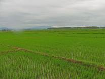
(Figure 10).
|

|
|
|
Figure 10 QR code and field image captured by
the GIES ground station (21/6/2026)
|
6 Conclusion
The case area possesses
a unique combination of favorable agroecological conditions, superior grain
quality and profound agricultural heritage that collectively support the
development of Huinan rice. The distinctive terroir conditions lay a natural
foundation for the excellent quality of Huinan rice. Independently developed
rice varieties and government- led industrial organization mechanisms constitute
two key pillars underpinning the branding development of Huinan rice.
Located in the river valley plain of the Changbai Mt. region, Huinan County
features a temperate continental monsoon climate with coincident precipitation
and thermal conditions during the growing season as well as large diurnal
temperature variation. The volcanic ash-derived soils are rich in essential
mineral nutrients and free from detectable heavy metal contamination, while
irrigation with pure mountain spring water contributes to natural mineral replenishment
within the agroecosystem. The synergistic effect of the above three conditions
makes this area an ideal place for high-quality rice cultivation and forms the defining
terroir attributes that distinguish Huinan rice from other rice products.
Well-adapted cultivars and superior product quality further enhance the
competitiveness of this geographical indication product. Relevant studies show
that locally suitable rice varieties perform well here. Locally independently
developed Hongke series, as well as Wuyoudao 4 and Zhongkefa 5, are
characterized by high yield and fine grain quality. Product quality assessment revealed
that local rice products are abundant in trace elements, with pollutant concentrations
and heavy metal contents far below national standards, presenting a high level
of food safety and prominent quality advantages that conform to the core
quality attributes of geographical indication products. Supported by a comprehensive
quality traceability system, an integrated production and management framework
suitable for geographical indication products has been established, which
provides vital support for the development and protection of geographical
indication brands.
Despite these advantages, several challenges remain, including
limited brand recognition, incomplete coverage of standardized production systems,
and relatively low value addition along the rice industrial chain. Addressing these
constraints through subsequent industrial upgrading, technological innovation, and
value chain enhancement will be essential for strengthening market
competitiveness. Meanwhile, it puts forward definite optimization directions
for agroecosystem protection and sustainable development of geographical
indication products in the future.
Author Contributions
Wang, P. was responsible for the overall design of the
study, conducting investigations, sampling, data collation, and manuscript
writing. He, J. W. provided overall guidance. Zhao, L. participated in field
investigation and manuscript writing. Meng, X. J. offered guidance on
ecological environment analysis. Meng, W. R. and Ai, Z. G. supervised the rice
production and management analysis. Sun, X. generated the spatial maps. Chen,
Y. and Lai, S. W. collected and processed samples. Tian, C. Y., Zhang, C. J.
and Zou, L. P. coordinated the investigations Zhao, G. Y., Yan, Y. X., Che, X.
C. and Tian, L. were responsible for the investigation, sampling, and data
collection. Wang, H. Q. was responsible for video production. The other authors
participated in data collection. All authors contributed to the discussion and
revision of the manuscript.
Acknowledgements
The
authors sincerely thank Professors Wang, Z. B., Liu, C., Song, X. F. and Fu, J.
Y. from the Institute of Geographic Sciences and Natural Resources Research,
Chinese Academy of Sciences, for their guidance and assistance in the project
initiation and research roadmap design of this case study.
Conflicts
of Interest
The authors
declare no conflicts of interest.
References
[1]
Fu, J.
Y., Du, X. L., Zheng, Q. S., et al. GIES
case dataset on rice permanent farmland in Lanjia Village, Jilin Province of
China [J]. Journal of Global Change Data & Discovery, 2021,
5(3): 275–289. https:// doi.org/10.3974/geodp.2021.03.06.
[2]
Wang,
P., He, J. W., Tian, C. Y., et al. GIES case dataset on Huinan rice permanent
basic farmland [J/DB/OL]. Digital
Journal of Global Change Data Repository, 2026. https://doi.org/10.3974/geodb.2026. 04.02.V1.
[3]
GCdataPR
Editorial Office. GCdataPR data sharing policy [OL].
https://doi.org/10.3974/dp.policy.2014.05 (Updated 2017).
[4]
Shi,
D. J. Analysis on current situation of water resources in Huinan County [J]. Science
and Technology Innovation Herald, 2017, 14(3): 66–68.
[5]
Liu,
S. R. Design of environmental protection and comprehensive treatment project
for tributaries of Songhua River in Huinan County [D]. Changchun: Jilin
University, 2018.
[6]
Tong,
J. J., He, H. X., Lou, A. Y. Analysis on water resources carrying capacity of
Jilin Province based on potential of external water transfer [J]. Water
Resources Planning and Design, 2022(9): 96–100.
[7]
Ministry
of Ecology and Environment of P. R. China, State Administration for Market
Regulation. Standard for irrigation water quality (GB 5084—2021) [S]. Beijing:
China Environment Publishing Group, 2021.
[8]
Ministry
of Ecology and Environment of P. R. China, State Administration for Market
Regulation. Soil environmental quality risk control standard for soil
contamination of agricultural land (Trial) (GB 15618—2018) [S]. Beijing: China
Environment Publishing Group, 2018.
[9]
National
Health Commission of P. R. China, State Administration for Market Regulation.
National food safety standard—maximum levels of contaminants in food (GB
2762—2022) [S]. Beijing: Standards Press of China, 2022.