GIES Case Study on Liuhe Rice
Permanent Basic Farmland
ZHAO Ling1 GAO Jiayu1 WEI Jiaxin1 YUE Yuxuan
2 GU Xiaohui3 ZHANG Qiong4 DONG Jiwei3 TAO Yuan3 LI Qiang5 GONG Wanming6 AN Fenghong7 ZOU Lixin8 WANG Maohua9 ZONG Guoli10 QIAN Jiaqi11 QIN Yong12 ZHANG Minglu13 GUO Ruiguang14
YAN Hongwei15 LI Dajing16 WANG Jun17 LIU Tiecheng18 CAO Dan19 SHI Yu20* MENG Xiangjun21* YU Yunbo22 HOU Zhengfa23 GUAN Yanli24 ZHANG Xicai25 YU Hongjun
26 LI Bin27 QIN Zhishuang1 TANG Duanwu1 ZHAO Zizheng1
1. Jilin Agricultural
University, Changchun 130118, China; 2. People’s Government of Liuhe County, Jilin Province,
Liuhe
135399, China; 3. Liuhe County Market Supervision
and Administration Bureau, Jilin Province, Liuhe 135399,
China; 4.
Agricultural Technology Extension Station of Liuhe County, Jilin Province,
Liuhe
135199,China; 5. People’s Government of Liuhe Township, Liuhe County,
Jilin Province, Liuhe 135300, China; 6. People’s Government of Xiangyang Town,
Liuhe County, Jilin Province, Liuhe 135305, China; 7. People’s Government of
Ankou Town, Liuhe County, Jilin Province, Liuhe 135304, China; 8. People’s
Government of Shengshui Town, Liuhe County, Jilin Province, Liuhe 135308,
China; 9. People’s Government of Hengtong Town, Liuhe County, Jilin Province,
Liuhe 135307, China; 10. People’s Government of Sanyuanpu Korean Ethnic Town,
Liuhe County, Jilin Province, Liuhe 135321, China; 11. People’s Government of
Wudaogou Town, Liuhe County, Jilin Province, Liuhe 135319, China; 12. People’s
Government of Hongshi Town, Liuhe County, Jilin Province, Liuhe 135325, China;
13. People’s Government of Tuoyaoling Town, Liuhe County, Jilin Province, Liuhe
135311, China; 14. People’s Government of Liunan Township, Liuhe County, Jilin
Province, Liuhe 135323, China; 15. People’s Government of Gushanzi Town, Liuhe
County, Jilin Province, Liuhe 135312, China; 16. People’s Government of
Liangshuihezi Town, Liuhe County, Jilin Province, Liuhe 135317, China; 17.
People’s Government of Luotongshan Town, Liuhe County, Jilin Province, Liuhe
135315, China; 18. People’s Government of Shijiadian Township, Liuhe County,
Jilin Province, Liuhe 135314, China; 19. People’s Government of Jiangjiadian
Korean Ethnic Township, Liuhe County, Jilin Province, Liuhe 135316, China; 20. Jilin Academy of Agricultural Sciences (Northeast
Innovation Center of Chinese Academy of Agricultural Sciences), Changchun 130033, China; 21. Jilin University of Finance and
Economics, Changchun 130117, China; 22. Jilin Watian Agricultural
Development Co., Ltd., Jilin Province, Liuhe 135316, China; 23. Jilin Liuhe
Guoxin Sheji Shangpin Agricultural Development Co., Ltd., Liuhe 135306,
China; 24.
Jilin Province Liuli Grain Co., Ltd., Liuhe 135119, China; 25. Sijiazi
Village, Jiangjiadian Korean Ethnic Township, Liuhe County, Jilin Province,
Liuhe
135316, China; 26. Liuhe County Jiangjiadian Fengtian Rice Industry Co., Ltd., Jilin Province,
Liuhe
135316, China; 27. Liaoning University, Shenyang 110036, China.
Abstract:
Liuhe County is located on the western foot of the Changbai Mt.
and in the hinterland of the Longgang Mt. in Jilin Province, China. Covering a
total area of 3,348 km2, it administers 15 townships, 3
subdistricts, and 219 administrative villages. In 2023, the county’s permanent
resident population was 251,900, and its regional GDP reached 9.227 billion CNY.
Benefiting from a volcanic ash substrate formed by the weathering of Cenozoic
basalt, natural mineral spring irrigation, a cool monsoon climate, and high
vegetation coverage, the region has developed a distinctive ecological
environment conducive to the production of nutrient-rich, safe, and
high-quality volcanic-ash-substrate rice. This ecological foundation underpins
the China Geographical Indication Certification Trademark of “Liuhe Rice”. This
study compiles and analyzes data on the location, geomorphology, meteorology,
water quality, soil properties, rice variety characteristics, rice quality, and
socio-economic conditions in Liuhe County. It systematically elucidates the
nutritional and safety advantages of volcanic-ash-substrate rice cultivated on
permanent basic farmland and proposes a sustainable development model
integrating habitat conservation, green production, whole-chain management,
brand development, and technological empowerment. The results indicate that
irrigation water in Liuhe is rich in calcium and magnesium, while the soils
contain abundant organic matter and mineral elements, with heavy metal
concentration far below the risk screening thresholds. The rice is enriched in
calcium, magnesium, phosphorus, selenium, and other nutrients, whereas lead and
cadmium are either undetected or present only at extremely low concentrations,
demonstrating significantly superior nutritional quality and safety compared
with conventional rice. Through ecological redline protection, soil
conservation, green cultivation practice, standardized production, traceability
and monitoring, and the integration of agriculture, culture, and tourism, the
study achieves a synergy balance between protecting this rare agricultural
habitat and improving industrial quality and efficiency. The case dataset
includes location data of the study area, physical geographic data, rice
variety characteristic data, management data, photographs, and images. The
dataset is archived in .shp, .tif, .xlsx, .docx, and .jpg formats, and consists
of 67 files with data size of 79.3 MB (compressed into 1 file with 39.8 MB).
Keywords: Changbai Mountain;
Liuhe County; rice; volcanic ash substrate; GIES; Case38
DOI: https://doi.org/10.3974/geodp.2026.03.11
Dataset Availability Statement:
The dataset supporting this paper
was published and is accessible through the Digital Journal of Global Change Data Repository
at: https://doi.org/10.3974/geodb.2026.04.03.V1.
1 Introduction
|
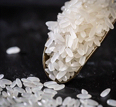
Figure 1 Liuhe County rice
|
Against the backdrop of consumption upgrading and
the deepening implementation of rural revitalization strategy, the protection
and sustainable development of high-quality geographical indication products
have thus become a major focus of market attention[1]. As one of
China’s most important ecological barriers and species gene pools, the Changbai
Mt. have nurtured a large number of agricultural products with distinct
regional characteristics, owing to their unique geology, landforms and climatic
conditions. Volcanic-ash-substrate rice is a typical representative example
among them (Figure 1). Liuhe County is located deep in the Longgang Mt. within
the Changbai Mountain Nature Reserve, where basalt landforms formed by Cenozoic
volcanic activity are widely distributed. Over long-term weathering, these
volcanic rocks have gradually transformed into mineral-rich soils with
physicochemical properties. Combined with irrigation from natural mountain
springs originating from the residual ranges of the Changbai Mt. and the ample
sunlight and large diurnal temperature range under a temperate continental
monsoon climate, results in more stable rice growth and avoids the phenomenon
of premature senescence in autumn. Together, these natural advantages endow
Liuhe volcanic-ash-substrate rice with its unique quality. As a traditional
agricultural area and a permanent basic farmland zone, Liuhe County is largely
free from major industrial pollution sources. With a forest coverage rate of
56.8%, the region has maintained a relatively intact ecosystem, thereby
providing an ideal habitat for the cultivation and sustainable development of
volcanic-ash-substrate rice.
However,
with the continuous growth in market demand, the development of
volcanic-ash-substrate rice industry is facing a series of critical challenges.
These includes how to expand cultivation areas while simultaneously
safeguarding the fragile volcanic-ash ecosystem and preventing soil degradation
and water contamination; how to enhance product added value and market
competitiveness through standardized production, quality control and brand
development; and how to establish a scientific monitoring and data management
system to support the sustainable development of the industry.
2 Metadata of the Dataset
Information on the title, authors, geographical
region, the year of the data, data files, data publisher, and data sharing
policies of GIES case dataset on Liuhe rice permanent
basic farmland[2] is shown in Table 1.
3 Case Dataset Development
3.1 Case Area
The case area is Liuhe County, located in the
southeastern Jilin Province and northwest Tonghua City (Figure 2). Liuhe County
extends from 41°54′N to 42°35′N and from 125°17′E to 126°35′E, and is situated
within the transitional zone between the Changbai Mt. and the Songliao Plain,
with a distance of 260 km from the main range of the Changbai Mt. It covers a
total land area of 3,348 km2, and administratively governs 15
townships, 3 sub-districts and 219 administrative villages. In 2023,
the county’s permanent resident population was 251,900.
3.2 Topography
Liuhe County is situated in
the transitional zone from the Changbai Mt. to the
Songliao Plain. The overall terrain is higher in the southeast and southwest
and lower in the northeast, exhibiting an inclination from the southwest and
southeast toward the northeast. The geomorphological landscape is composed
primary of middle-low mountains, volcanic lava platforms, and river valley
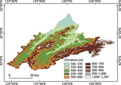
basins. Analysis of elevation and slope within the case area reveals that the
middle-low mountains are mostly at elevations ranging from 400 m to 1,000 m, with the highest peak reaching
1,293 m, and are mainly concentrated in the central-southern and
southeastern parts of the county (Figure 3). Lava platforms account for 5% of
the county’s total area, are primarily located in the southeastern part of the
county, and belong to the Longgang volcanic cluster; the surface is relatively
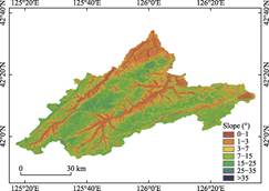
flat, but steep slopes often occur at the margins. River valley basins account
for 15% of the county’s total area and are mainly distributed along the Yitong,
Santong, Hani, Woji Rivers systems. These areas are
dominated by gentle
slopes of less than 7° with low-relief and relatively flat terrain. The hydrological conditions are characterized by balanced water retention and drainage
conditions, together with stable surface runoff, which are highly favorable for moisture and nutrient conservation in volcanic ash soils. Consequently,
this is the core
cultivation area for volcanic-ash- substrate rice (Figure 4).
Table 1 Metadata summary
of GIES case dataset on Liuhe rice permanent basic farmland
|
Items
|
Descriptions
|
|
Dataset full name
|
GIES case dataset on Liuhe rice permanent
basic farmland
|
|
Dataset short name
|
LiuheRiceCase38
|
|
Authors
|
Zhao, L., Jilin Agricultural University, zhaol@jlau.edu.cn
Gao, J. Y., Jilin Agricultural University, 646882391@qq.com
Wei, J. X., Jilin Agricultural University, 2385091066@qq.com
Yue, Y. X., People’s Government of Liuhe County, Jilin Province,
704184172@qq.com
Gu, X. H., Liuhe County Market Supervision and Administration Bureau,
1992442074@qq.com
Zhang, Q., Agricultural Technology Extension Station of Liuhe County,
Jilin Province, joan1971@126.com
Dong, J. W., Liuhe County Market Supervision and Administration Bureau,
510904565@qq.com
Tao, Y., Liuhe County Market Supervision and Administration Bureau,
taoyuan200808@126.com
Li, Q., People’s Government of Liuhe Town, Liuhe County, Jilin
Province, 379372394@qq.com
Gong, W. M., People’s Government of Xiangyang Town, Liuhe County,
Jilin Province, lhxydzb@163.com
An, F. H., People’s Government of Ankou Town, Liuhe County, Jilin
Province, 1398344312@qq.com
Zou, L. X., People’s Government of Shengshui Town, Liuhe County, Jilin
Province, sszdb@163.com
Wang, M. H., People’s Government of Hengtong Town, Liuhe County, Jilin
Province, htdb123@163.com
Zong, G. L., People’s Government of Sanyuanpu Korean Ethnic Town,
Liuhe County, Jilin Province, sypzf2008@163.com
Qian, J. Q., People’s Government of Wudaogou Town, Liuhe County, Jilin
Province, wdgdjbgs.163.com
Qin, Y., People’s Government of Hongshi Town, Liuhe County, Jilin
Province, liuhehongshi@163.com
Zhang, M. L., People’s Government of Tuoyaoling Town, Liuhe County,
Jilin Province, hszml001@163.com
Guo, R. G., People’s Government of Liunan Township, Liuhe County,
Jilin Province, 29602538@qq.com
Yan, H. W., People’s Government of Gushanzi Town, Liuhe County, Jilin
Province, 29551541@qq.com
Li, D. J., People’s Government of Liangshuihezi Town, Liuhe County,
Jilin Province, 110129446@qq.com
Wang, J., People’s Government of Luotongshan Town, Liuhe County, Jilin
Province, ltsdb666@163.com
Liu, T. C., People’s Government of Shijiadian Township, Liuhe County,
Jilin Province, 726417277@qqq.com
Cao, D., People’s Government of Jiangjiadian Korean Ethnic Town, Liuhe
County, Jilin Province, lhxjjdcxzxrmzh@163.com
Shi, Y., Jilin Academy of Agricultural Sciences (Northeast Innovation
Center of Chinese Academy of Agricultural Sciences), shiyu9434@163.com
Meng, X. J., Jilin University of Finance and Economics, mengxj617@163.com
Yu, Y. B., Jilin Watian Agricultural Development Co., Ltd., Jilin
Province, watian2007@126.com
Hou, Z. F., Jilin Liuhe Guoxin Sheji Shangpin Agricultural Development
Co., Ltd., 117407627@qq.com
Guan, Y. L., Jilin Province Liuli Grain Co.Ltd., 583820333@qq.com
Zhang, X. C., Sijiazi Village, Jiangjiadian Korean Ethnic Township,
Liuhe County, Jilin Province, zxc20251209@163.com
Yu, H. J., Liuhe County Jiangjiadian Fengtian Rice Industry Co., Ltd.,
Jilin Province, 815249569@qq.com
Li, B., Liaoning University, 157642179@qq.com
Qin, Z. S., Jilin Agricultural University, qinzhishuang@jlau.edu.cn
Tang, D. W., Jilin Agricultural University, 745925172tdw@163.com
Zhao, Z. Z., Jilin Agricultural University, 2814745700@qq.com
|
|
Geographical region
|
Liuhe County, Tonghua City, Jilin Province
|
|
Year
|
2000–2024
|
|
Data format
|
.shp, .tif, .xlsx, .docx, .jpg
|
|
Data size
|
79.3 MB
|
|
Data files
|
Location
data, physical geographical data, rice variety characteristics data,
management data, etc.
|
|
Publisher
|
Global
Change Research Data Publishing System, http://www.geodoi.ac.cn
|
|
Address
|
No. 11A,
Datun Road, Chaoyang District, Beijing 100101, China
|
(To be continued on the next page)
(Continued)
|
Items
|
Descriptions
|
|
Data sharing policy
|
(1) Data are openly available and can be free downloaded via the
Internet; (2) End users are encouraged to use Data subject to citation; (3) Users, who are by definition also
value-added service providers, are welcome to redistribute Data subject to written permission
from the GCdataPR Editorial Office and the issuance of a Data redistribution license; and (4) If Data are used to compile new datasets, the “ten percent principle”
should be followed such that Data
records utilized should not surpass 10% of the new dataset contents, while
sources should be clearly noted in suitable places in the new dataset[3]
|
|
Communication
and searchable system
|
DOI, CSTR,
Crossref, DCI, CSCD, CNKI, SciEngine, WDS, GEOSS, PubScholar, CKRSC
|
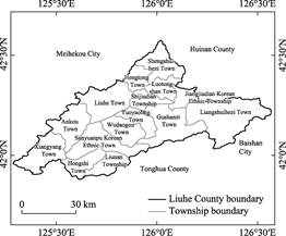
Figure 2 Map of the geo-location and administrative divisions of Liuhe
County
|
|
|
|
Figure
3 Elevation
classification map of Liuhe County
|
Figure
4 Slope
classification map of Liuhe County
|
3.3 Land Use and Vegetation
Cover
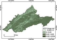
The authors utilized Landsat-5 and Landsat-9
imagery to derive the Normalized Difference Vegetation Index (NDVI) for the
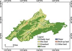
case area. Liuhe County exhibits distinct spatial characteristics in land use
and vegetation: the mid-low mountainous areas are dominated by forestry, with
significantly increased vegetation cover serving as an important ecological
barrier; the lava platform shows increased vegetation cover and favorable
hydrothermal conditions suitable for developing characteristic agriculture
(e.g., rice cultivation); the valley basin maintains relatively stable
vegetation cover and is dominated by agricultural land use (Figures 5 and 6).
Cultivated
land in Liuhe County is mainly composed of thin volcanic ash-derived soils,
with a single cropping system per year, representing a transitional black soil
belt grain-
|
|
|
|
Figure 5 Change rate of
NDVI in Liuhe County (2000–2025)
|
Figure 6 Land
use map of Liuhe County (2024)
|
producing area. The relatively high NDVI values in
this region indicate a sound ecological background and vigorous growth of paddy
field vegetation. Dense vegetation cover helps maintain the stability of the
paddy field ecosystem, reduce the risks of soil erosion and non- point source
pollution, thereby forming a unique habitat support system characterized by the
integrated framework of “basalt platform-volcanic ash substrate
-wetlands/reservoir clusters”.
3.4 Climatic Conditions
Liuhe County features a temperate continental
monsoon climate, which is highly suitable for the growth of high-quality
japonica rice. The coincidence of rainfall and heat during summer facilitates
vigorous rice growth and dry matter accumulation. The large diurnal temperature
variation in autumn accelerates the translocation of photosynthates to grains
and promotes the synthesis of starch and flavor substances. Despite no rice
cultivation in winter, the prolonged period of severe cold and snow cover
effectively reduce overwintering pest and disease populations and lower
pesticide applications.
According to data
from the Liuhe Meteorological Bureau, the mean temperature is –15.001 ℃ in
January and 21.548 ℃ in July. The annual precipitation averages 736.3 mm,
mainly concentrated from June to August. The total annual sunshine duration is
2,560 h, among which 1,160 h occur during the rice growing period. The active
accumulated temperature above 10 ℃ ranges from 2,214 ℃ to 2,948 ℃,
with a frost-free period of 130 to 140 d (Figure 7). The relatively short
frost-free period imposes natural selective pressure on
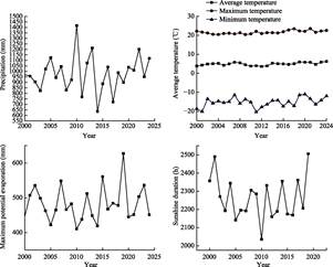
Figure 7 Climate characteristics change of Liuhe
County
early-maturing
rice varieties, concentrating grain filling in periods with optimal light and
heat conditions, and comprehensively improving both the taste quality and food
safety of Liuhe rice.
3.5 Water Conditions
The
case area is endowed with abundant water resources, including 3 medium-sized
reservoirs and 97 small reservoirs and more than 60 rivers of varying sizes
originate from the Changbai Mt. The total water surface area reaches 7,600 ha, with an average
annual total water resource volume of 1.28 billion m3. The unique
hydrological system characterized by abundant water yield, clean water quality,
mineral replenishment and precise water regulation, not only meets the
physiological water demand of rice, but also promotes dry matter accumulation.
It serves as a critical ecological foundation for the distinctive properties
of Liuhe rice, including green production,
high quality and calcium enrichment.
|
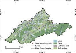
Figure 8 Distribution map of water sampling
sites in Liuhe County
|
A total of 11 water
samples were collected from paddy fields,
irrigation canals and sunning water ponds in the case area (Figure 8)
and subsequently analyzed by the Institute of Agricultural Quality Standards
and Testing Technology, Jilin Academy of Agricultural
Sciences (Northeast China Innovation Center for Agricultural Science and
Technology).
Water quality
testing (Table 2) showed that pH ranged from 6.99 to 7.57, electrical
conductivity ranged from 90.5 to 420 μS/cm, calcium content ranged from 5,844 to 63,018 μg/L, and magnesium content
ranged from 1,908 to 20,605 μg/L. The water is rich in minerals and exhibits a
low- salinity, neutral to weakly alkaline condition, ensuring rice safety and
the formation of mineral-rich nutrition from the source.
Table 2 Statistical testing results of water nutrient in Liuhe
County
|
Samples
|
pH
|
Total water-soluble salt content (electrical conductivity at 25 ℃)
|
Mg
|
P
|
K
|
Ca
|
Mo
|
Mn
|
Fe
|
|
Unit
|
–
|
μS/cm
|
μg/L
|
μg/L
|
μg/L
|
μg/L
|
μg/L
|
μg/L
|
μg/L
|
|
W1
|
7.57
|
153
|
7,384
|
24.7
|
1,380
|
9,411
|
1.20
|
0.950
|
118
|
|
W2
|
7.38
|
110
|
5,301
|
42.1
|
586
|
5,844
|
0.72
|
0.982
|
432
|
|
W19
|
7.04
|
173
|
5,646
|
27.3
|
1,109
|
15,505
|
0.71
|
1.340
|
167
|
|
W21
|
7.30
|
188
|
9,260
|
55.4
|
901
|
13,648
|
0.99
|
1.160
|
101
|
|
W22
|
7.28
|
167
|
5,574
|
38.5
|
978
|
15,927
|
0.23
|
0.770
|
162
|
|
W23
|
7.12
|
90.5
|
1,908
|
61.8
|
1,871
|
6,785
|
0.46
|
3.110
|
449
|
|
W24
|
6.99
|
414
|
20,605
|
45.6
|
369
|
63,018
|
0.83
|
2,444
|
231
|
|
W25
|
7.37
|
420
|
18,163
|
67.0
|
452
|
54,753
|
0.78
|
11.700
|
71
|
|
W26
|
7.45
|
316
|
9,239
|
58.8
|
1,914
|
44,909
|
1.69
|
5.510
|
80
|
|
W27
|
7.48
|
327
|
8,146
|
69.1
|
426
|
41,162
|
0.55
|
3.700
|
164
|
|
W28
|
7.48
|
256
|
8,286
|
47.7
|
660
|
32,305
|
1.11
|
1.830
|
52
|
Note: water samples in
this study were collected in multiple batches, with samples from each batch
numbered independently according to the sampling sequence. Consequently, the sample IDs are
non-consecutive, and this numbering scheme does not affect the reliability of
subsequent statistical analyses or conclusions. The same below. –
indicates no corresponding data.
Among
the 11 tested water samples, the concentrations of all hazardous substances
were far below the limit values specified in the national Standard for
irrigation water quality (GB 5084—2021)[4] (Table 3).
Table 3 Statistical testing results of heavy metal
content in water of Liuhe County Unit: μg/L
|
Samples
|
Cr
|
Ni
|
Cu
|
Zn
|
As
|
Se
|
Cd
|
Hg
|
Pb
|
|
W1
|
0.286
|
0.80
|
0.84
|
ND
|
0.78
|
0.378
|
ND
|
0.276
|
0.050
|
|
W2
|
0.410
|
1.34
|
1.16
|
ND
|
0.93
|
0.444
|
ND
|
0.194
|
0.141
|
|
W19
|
0.185
|
1.05
|
0.69
|
ND
|
1.01
|
0.185
|
ND
|
0.087
|
0.094
|
|
W21
|
0.278
|
1.35
|
1.36
|
ND
|
1.28
|
0.170
|
ND
|
0.090
|
0.107
|
|
W22
|
0.232
|
0.57
|
2.49
|
ND
|
1.07
|
0.064
|
ND
|
0.089
|
ND
|
|
W23
|
0.741
|
0.90
|
3.65
|
0.970
|
1.46
|
1.080
|
ND
|
0.089
|
0.094
|
|
W24
|
0.263
|
2.46
|
2.88
|
0.883
|
2.31
|
0.438
|
ND
|
0.100
|
ND
|
|
W25
|
0.123
|
1.22
|
2.55
|
ND
|
4.73
|
0.118
|
ND
|
0.092
|
ND
|
|
W26
|
0.386
|
0.71
|
4.42
|
ND
|
1.88
|
0.322
|
ND
|
0.088
|
ND
|
|
W27
|
0.316
|
0.45
|
2.23
|
ND
|
1.36
|
0.023
|
ND
|
0.086
|
ND
|
|
W28
|
0.299
|
0.70
|
3.03
|
ND
|
1.51
|
0.096
|
ND
|
0.086
|
ND
|
|
Limits[4]
|
≤100
|
≤200
|
≤500
|
≤2,000
|
≤50
|
≤20
|
≤10
|
≤1
|
≤200
|
Note: ND indicates not
detected.
3.6 Soil Conditions
|
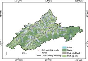
Figure 9 Distribution
map of soil sampling sites in Liuhe County
|
Liuhe County features a unique volcanic
geomorphology. Basalt magma upwelled through massive crustal fractures, forming
the extensive Changbai Mt. basalt platform. In this study, 9 soil samples were
collected from concentrated rice cultivation fields in the case area (Figure 9).
The concentrations of trace element contents in soil samples were analyzed by
the Jilin Academy of Agricultural Sciences (Northeast Innovation Center for
Agricultural Science and Technology of China).
The soil samples exhibited pH ranging from 5.36 to
6.26, organic matter content of 11.7–34.3g/kg, and total potassium
concentration of 18,280–24,570 mg/kg, with abundant calcium, magnesium, iron,
and manganese (Table 4). From the perspective of growth-promoting mechanisms,
calcium can strengthen the cell wall structure of rice plants, enhancing their
lodging resistance and disease tolerance. The abundant calcium in the soil
results in significantly higher calcium content in Liuhe rice compared with
conventional rice, markedly improving its nutritional value. Magnesium, as a
core component of chlorophyll, can effectively improve photosynthetic
efficiency.
Table 4 Statistical
testing results of soil nutrient in Liuhe County
|
Test item
|
S19
|
S21
|
S22
|
S23
|
S24
|
S25
|
S26
|
S27
|
S28
|
Average value
|
|
pH
|
5.93
|
5.36
|
5.78
|
5.80
|
5.90
|
5.68
|
6.08
|
5.89
|
6.26
|
5.85
|
|
OM(g/kg)
|
34.3
|
27.40
|
20.60
|
31.00
|
20.70
|
17.10
|
20.00
|
26.30
|
11.70
|
23.23
|
|
TN (mg/kg)
|
1,950
|
1,690
|
1940
|
2,570
|
2,110
|
2,140
|
2,710
|
1,740
|
2,160
|
2,112.22
|
|
TP (mg/kg)
|
843.3
|
1,130
|
830
|
1,080
|
930
|
940
|
1,210
|
970
|
760
|
965.92
|
|
TK (mg/kg)
|
19,200
|
20,610
|
19,500
|
20,090
|
19,630
|
20,290
|
18,280
|
24,570
|
18,950
|
20,124.44
|
|
Mg (mg/kg)
|
8,336
|
6,449
|
7,974
|
9,074
|
6,726
|
8,081
|
11,867
|
8,309
|
8,042
|
8,317.56
|
|
Ca (mg/kg)
|
4,156
|
4,336
|
3,577
|
4,058
|
2,940
|
5,546
|
25,358
|
10,707
|
4,396
|
7,230.44
|
|
Mn (mg/kg)
|
533
|
679
|
473
|
368
|
439
|
828
|
549
|
509
|
563
|
549
|
|
Fe (mg/kg)
|
33,426
|
34,223
|
36,100
|
36,341
|
32,428
|
31,425
|
36,376
|
36,296
|
31,910
|
34,280.56
|
Among
the 9 soil samples, the concentrations of chromium, nickel, copper, zinc,
arsenic, cadmium, mercury, and lead were all far below the risk screening
values specified in GB15618—2018[5]. The average values of copper,
zinc, and cadmium were 27.8 mg/kg, 101.1 mg/kg, and 0.24 mg/kg, accounting for
only 55.6%, 50.5%, and 62.2% of the screening values, respectively. The test
results presented in Table 5 indicate that the soil environmental quality in
this region is excellent, clean, and pollution-free, providing a fundamental
guarantee for the production of safe and high-quality volcanic ash-based rice.
The extremely low contents of chromium and nickel further confirm that when
water flows through the basalt strata, it does not dissolve excessive heavy
metals, reflecting the stability and safety of the volcanic rock filtration
system.
Table 5 Statistical testing results
of soil
heavy metal contents in Liuhe County
|
Test item
|
S19
|
S21
|
S22
|
S23
|
S24
|
S25
|
S26
|
S27
|
S28
|
Average value
|
Limits[5]
|
|
Cr (mg/kg)
|
82.3
|
147.7
|
100.8
|
88.3
|
74.3
|
72.3
|
94.7
|
220.1
|
83.5
|
107.1
|
≤250
|
|
Ni (mg/kg)
|
37.7
|
32.3
|
30.6
|
35.6
|
30.8
|
31.7
|
37.3
|
30.9
|
34.8
|
33.5
|
≤70
|
|
Cu (mg/kg)
|
23.3
|
33.7
|
21.1
|
28.6
|
24.0
|
31.9
|
35.8
|
26.4
|
25.1
|
27.8
|
≤50
|
|
Zn (mg/kg)
|
88.8
|
90.5
|
89.5
|
111
|
83.8
|
99.8
|
173
|
83.1
|
90.6
|
101.1
|
≤200
|
|
As (mg/kg)
|
7.44
|
11.9
|
7.53
|
7.05
|
7.18
|
19.5
|
10.1
|
5.54
|
7.82
|
9.34
|
≤30
|
|
Cd (mg/kg)
|
0.261
|
0.260
|
0.228
|
0.337
|
0.205
|
0.295
|
0.2
|
0.212
|
0.240
|
0.28
|
≤0.4
|
|
Hg (mg/kg)
|
0.0511
|
0.0682
|
0.0388
|
0.0421
|
0.0363
|
0.0425
|
0.0478
|
0.0217
|
0.0386
|
0.043
|
≤0.5
|
|
Pb (mg/kg)
|
25.1
|
30.8
|
26.3
|
29.1
|
23.6
|
29.9
|
47.4
|
21.1
|
25.3
|
28.7
|
≤100
|
4 Liuhe Rice Product
Characteristic Data
4.1 Characteristics of
Major Rice Cultivars
(1)
Wuyoudao No. 4
Wuyoudao
No. 4 is a conventional late-maturing japonica rice cultivar characterized by
translucent grains and excellent eating quality. It is cultivated using
alternate shallow and intermittent irrigation, resulting in outstanding grain
quality. The growth duration is 143 d, requiring an accumulated temperature
above 10 ℃ of approximately 2,850 ℃, belonging to the medium-late
maturing category. The cultivar exhibits a compact architecture with erect flag
leaves, green stems and foliage and a plant height of 122.1 cm. It exhibits
strong tillering ability, with an effective panicle number of 4.095 million per
ha. Panicles are curved and 19.5 cm in length, containing an average of 115.8
grains per panicle, and a seed setting rate of 78.4%. Grains are spindle-shaped
with yellow glumes and apiculi, sparse awns; and a thousand-grain weight of
27.7 g.
Regarding
the main rice quality indicators, the brown rice rate is 84.7%, milled rice
rate is 72.7%, head milled rice rate is 64.8%, grain length is 6.3 mm,
length-to-width ratio is 2.7, chalky grain rate is 46.0%, transparency is grade
1, alkali spreading value is grade 7.0, gel consistency is 65 mm, amylose
content is 16.6%, and protein content is 7.30%[6].
(2) Zhongkefa No. 5
Zhongkefa
No. 5 is a conventional japonica rice cultivar with a whole growth duration of
150.1 d. Its plant height is 102.8 cm, and the panicle length is 17.8 cm. The
effective panicle number reaches 4.095 million panicles per ha, with 118.3
grains per panicle, a seed setting rate of 79.9%, and a thousand-grain weight
of 26.9 g. The comprehensive rice blast index was 2.0 and 2.4 in two
consecutive years, and the maximum neck blast loss rate reached Grade 5,
indicating moderate susceptibility to rice blast. The main grain quality
indicators are as follows: the head rice rate is 70.1%, the chalky grain rate
is 6.0%, the chalkiness degree is 1.8%, the amylose content is 16.1%, the gel
consistency is 70 mm, and the length-to-width ratio is 3.0. This cultivar was
awarded the Gold Medal in the japonica rice group at the Fifth National
High-Quality Rice Evaluation[7].
(3) Jihong No. 6
Jihong No. 6
is a medium-to late- maturing, aromatic japonica rice variety belonging to the
genus Oryza (family Poaceae). This variety has a growth duration of
approximately 138 d, a plant height of 104 cm, a panicle
length of 17.3 cm, and a thousand-grain weight of 24.0 g. In terms of disease
resistance, it exhibits moderate resistance to seedling and leaf blast, but is
susceptible to panicle blast.
Regarding the main rice quality
indicators, the cultivar exhibits a brown rice rate of 82.6%, milled rice rate
of 74.3%, head milled rice rate of 70.4%, grain length of 5.0 mm,
length-to-width ratio of 1.7, chalky grain rate of 13.0%, chalkiness degree of
1.3%, transparency of grade 1, alkali spreading value of grade 6.7, gel
consistency of 88 mm, amylose content of 15.6%, and protein content of 6.88%.
4.2 Product
Quality Data
2 rice
samples representing major local cultivars were analyzed in this study. Rice
Sample 1 (named “Jitong” for laboratory submission) was randomly collected from
a family farm in Jiangjiadian Township. This sample belongs to is the super
rice category (including Jihong No. 6 and other varieties, which are all
small-grain varieties with similar characteristics; they are not distinguished
during purchasing, processing, and marketing, and are collectively referred to
as super rice). Rice Sample 2 (named “Jiangdao” for laboratory submission) was
a mixed sample sourced from family farms in Sijiazi Village, Jiangjiadian
Korean Ethnic Township, as well as from Watian Rice and Guoxin Rice. The principal
cultivar is Wuyoudao No. 4 (Daohuaxiang No. 2). All samples were analyzed by
the Institute of Agricultural Product Quality Safety and Inspection,
Heilongjiang Academy of Agricultural Sciences. The results are shown in Tables 6
and 7.
Table 6 Statistical
testing results of trace element (nutrient) of Liuhe rice
|
Test item
|
Sample
1
|
Sample
2
|
Samples
|
Sample
1
|
Sample
2
|
|
Ca (mg/kg)
|
71.6
|
67.3
|
Co (mg/kg)
|
0.00477
|
0.00438
|
|
K (mg/kg)
|
888
|
652
|
Se (mg/kg)
|
0.043
|
0.097
|
|
P (mg/kg)
|
907
|
879
|
Cu (mg/kg)
|
1.92
|
1.74
|
|
Mg (mg/kg)
|
211
|
200
|
Mo (mg/kg)
|
0.426
|
0.436
|
|
Mn (mg/kg)
|
12.3
|
11.3
|
Ti (mg/kg)
|
0.167
|
0.134
|
|
Fe (mg/kg)
|
4.09
|
3.20
|
Si (mg/kg)
|
69.6
|
57.5
|
|
Zn (mg/kg)
|
12.9
|
13.3
|
|
|
|
Table 7 Statistical
testing results of safety and hygiene indicators of Liuhe rice
|
Test item
|
Sample
1
|
Sample
2
|
Limits[8]
|
Test item
|
Sample
1
|
Sample
2
|
Limits[8]
|
|
Pb (mg/kg)
|
ND
|
ND
|
0.2
|
Ni (mg/kg)
|
ND
|
ND
|
/
|
|
Cd (mg/kg)
|
0.0136
|
0.0164
|
0.2
|
As (mg/kg)
|
0.0993
|
0.128
|
0.35
|
|
Cr (mg/kg)
|
0.0911
|
0.0840
|
1.0
|
Hg (mg/kg)
|
0.00552
|
0.00464
|
0.02
|
The rice samples from the case
area exhibited high concentrations of calcium, phosphorus, and magnesium.
Specifically, the calcium concentrations ranged from approximately 67.3 to 71.6 mg/kg, phosphorus concentrations ranged from
approximately 879 to 907 mg/kg, and magnesium concentrations ranged from
approximately 200 to 211 mg/kg, reflecting the enrichment effect of
mineral elements in the volcanic rock soil. In addition, trace elements
including zinc, manganese, iron, and selenium were detected in all samples,
further demonstrating the advantage of volcanic ash-based rice in terms of
trace element concentrations. Magnesium is an important mineral involved in
hundreds of biochemical reactions in the human body, and is essential for
maintaining neuromuscular function and stabilizing blood glucose and blood
pressure. Therefore, the products from the case area also exhibit strong
competitiveness with respect to certain trace elements.
The heavy metal concentrations in both samples complied
with the maximum permissible limits specified in the National food safety
standard—maximum levels of contaminants in food (GB 2762—2022)[8]
(Table 7). This reflects that Liuhe County performs well in controlling
hazardous elements, with no detected exceedances, ensuring the food safety of
the rice consumption.
5 Socioeconomic Development and
Industrial Management
5.1 Socioeconomic
Development of Liuhe County
From 2020 to 2023, Liuhe
County experienced a continuous population outmigration, however, its overall
economic development level continued to improve steadily, and the comprehensive
agricultural production capacity continued to strengthen (Table 8). As a
traditional advantageous and characteristic industry in Liuhe County, the rice
industry has consistently played an important role in improving quality and
efficiency, conserving water and soil resources, and diversifying the planting
structure, leveraging the region’s high-quality black soil resources and
ecological conditions. By reducing low-efficiency planting areas and developing
high-quality premium rice, the industry has effectively promoted high-quality
agricultural development in the county.
Table 8 Socioeconomic statistics
of Liuhe County (2020–2023)
|
Year
|
Resident population
(104 persons)
|
GDP
(106 CNY)
|
GDP per capita
(CNY)
|
Added value of primary industry
(106 CNY )
|
Grain cultivated
area (ha)
|
Grain yield
(107 kg)
|
Rice cultivated area (ha)
|
Rice yield
(107 kg)
|
|
2020
|
35.39
|
79.92
|
22,485
|
21.18
|
88,350
|
56.68
|
20,180
|
14.1
|
|
2021
|
26.49
|
82.74
|
30,782
|
21.56
|
88,400
|
57.7
|
18,458
|
13.2
|
|
2022
|
25.53
|
88.83
|
34,152
|
24.18
|
89,439
|
58.4
|
16,374
|
11.45
|
|
2023
|
25.19
|
92.27
|
36,384
|
23.81
|
89,664
|
59.4
|
16,136
|
11.41
|
5.2 History and Heritage of Rice Production
According to historical records, rice cultivation
in Liuhe County can be traced back to the early Tang Dynasty (early 7th
century). In the 32nd year of the Guangxu reign of the Qing Dynasty (1906 CE),
irrigation canals were constructed to divert water for irrigation, leading to
contiguous paddy field cultivation, marking the emergence of systematic
irrigation engineering and rice cultivation techniques in this region. Liuhe
rice gained renown for its plump grains, crystal clarity, rich aroma, delicate
sweetness, high nutritional value, and pure taste, earning a distinguished
reputation both domestically and abroad. Throughout the Song, Yuan, Ming, and
Qing dynasties, Liuhe rice was consistently a tribute rice to the imperial
court, ranking alongside the “Three Treasures of Northeast China” (ginseng,
sable fur, and antler velvet) for royal consumption. Following the founding of
the People’s Republic of China, Liuhe rice, possessing unparalleled quality and
edibility, became the designated rice for state banquets at the Great Hall of
the People.
According
to the Annals of Liuhe County, at the time of the county’s establishment in
1902, approximately 3,300 ha of farmland had already been reclaimed.
The main crops included soybean, sorghum, maize, millet, wheat, and adzuki
bean, followed by rice and upland rice (dryland rice), barley, barnyard millet,
buckwheat, broomcorn millet, and mung bean. In the early period of the county’s
establishment, some Korean ethnic groups migrated to Liuhe, introducing rice
cultivation techniques, and paddy rice farming began.
By
the time of the founding of the People’s Republic of China in 1949, the rice
planting area had expanded to 4,652 ha. Relying on the volcanic rock landforms,
the Korean ancestors, developed unique rice cultivation traditions. They
selected indigenous japonica varieties that were tolerant to low fertility and
had good taste, fertilized the land mainly with organic manure supplemented by
limited chemical fertilizers, and followed seasonal rhythms including soaking
seeds at the Spring Equinox and harvesting at the Autumn Equinox. These
practices formed a characteristic agricultural tradition centered on farming in
harmony with climate conditions. For irrigation, they used volcanic fissure
water to construct “open canal and underground drain” systems: open canals for
water diversion and underground drains for drainage, following the rule of
“shallow irrigation at tillering stage, deep irrigation at booting stage, and
field drying at maturity stage”, achieving alternating wet-dry conditions. Rice
processing and consumption retained the traditional habit of “grinding fresh for
immediate eating”, with stone mills preserving nutrients; brown rice was used
for porridge, and rice milk for specialty foods. During the autumn harvest
season, the “New Rice Festival” was held, where freshly harvested rice was
steamed, rice cakes were made, and local community celebrated the harvest while
showing reverence for farming culture. Regarding inheritance, the
“master-apprentice” approach passed down techniques, while enterprises have
integrated tradition with modern technology, introducing bio-organic
fertilizers and intelligent monitoring equipment. Exhibition halls and training
workshops have also been established, revitalizing the volcanic ash-based rice
farming culture.
Furthermore,
Liuhe County has made notable progress in integrating traditional cultivation
techniques of volcanic ash-based rice with modern agricultural technologies.
Through cultural activities such as the New Rice Festival and agricultural
extention training programs, the county has not only preserved the century-old
culture heritage of volcanic ash-based rice cultivation, but has also promoted
the application of modern technologies in traditional agriculture, thereby
injecting new momentum into the sustainable development of the volcanic
ash-based rice industry.
5.3 Whole-Process
Quality Control of Rice Production
Liuhe County has established a standardized
planting and whole-process quality control system for rice cultivated on
volcanic ash substrates. The system integrated seedling raising, field
cultivation, irrigation, fertilization, green pest prevention, harvesting,
processing, warehousing and quality inspection into a unified management
framework. By implementing the “Six Unifications” management model, the county
achieves classified harvesting and segregated storage, and ensures traceability
at key production points throughout the whole chain, and thereby guarantee the
stable and consistent quality of local rice products.
5.3.1
Seed Treatment
Before seed soaking, rice seeds are spread evenly
into a thin layer with thickness of 5–7 cm and sun‑dried under weak light
for 2–3 d, with turning 3–4 times per day. Fungicides are applied for seed
disinfection; the liquid level should be 15 cm above the seeds. The seeds are
soaked for 5–7 d with an accumulated temperature of 100 ℃ and stirred twice
daily. Seed coating agents can also be used as an alternative. During
germination acceleration, the seed pile thickness shall not exceed 50 cm, the
temperature is controlled at 28–30 ℃, and turning is conducted 3–4 times per
day. After 80% of the seeds break through the glume, the seeds are transferred
to a cool and shaded place for slow cooling before subsequent use.
5.3.2
Sowing
The greenhouse should be covered with plastic film
15 days prior to sowing. Seedbeds are shallowly tilled to a depth of 5–10 cm,
and fully watered one day in advance. The seedbed soil is sieved and adjusted
to a pH of 4.5–5.5 prior to use. Sowing is conducted from early to mid-April
using either flat tray or bowl type blanket seedling cultivation methods. For machine-transplanting
trays, 100–120 g of per-germinated seeds is sown per tray; whereas 60–80 g per
tray is used for manual-transplanting trays. In bowl-type nursery trays, 4–6
seeds are sown in each cell.
5.3.3
Nursery Management
Stage-specific precision regulation is adopted for
nursery management. From sowing to seedling emergence, the seedbed is
thoroughly watered in a timely manner in case of water shortage. Plastic film
covering would be removed once the seedling emergence rate exceeds 60%, and
greenhouse temperature shall be controlled below 30 ℃. From seedling emergence
to the 1.1-leaf stage, greenhouse temperature is maintained at 25 ℃–28 ℃ to
keep bed soil consistently moist. During the 1.1–2.5 leaf stage, the greenhouse
temperature is kept at approximately 25 ℃, and moderate ventilation is carried
out on sunny days for seedling hardening. From the 2.5-leaf stage to
transplanting, ventilation intensity is increased when the minimum nighttime
temperature is higher than 10 ℃. Plastic film is removed at night 7–10 days
before transplanting. Meanwhile, the “three-belt” management measures are
implemented: 15–20 g of ammonium sulfate is applied per square meter of
seedbed; thiamethoxam is sprayed to control rice leafminer; and Bacillus
subtilis is applied to promote seedling regreening and tillering.
5.3.4
Transplanting
Transplanting is carried out from 15 to 25 May
with a planting spacing of 30 cm × (13–20 cm), with a planting density of 17–25
hills per square meter. Uniform planting depth is maintained during
transplanting to avoid seedling bending and missing hills.
5.3.5
Field Management
Field management strictly follows the principles
of heavy base fertilizer application, nitrogen reduction and delayed
application of tiller fertilizer during the tillering stage, and equal dosage
rates of panicle fertilizer and tiller fertilizer. For base fertilizer, 20–40 m3
of decomposed farmyard manure is applied per ha, combined with phosphorus
fertilizer, potassium fertilizer and zoned quantitative nitrogen fertilizer. In
saline-alkali soils, zinc sulfate is additionally applied to improve soil
conditions and nutrient availability. Tillering fertilizer is applied in mid-June,
and panicle fertilizer together with supplementary potassium fertilizer is
supplied in early to mid-July.
A
zone-specific irrigation regime is implemented throughout the growing season.
Shallow water management is retained from transplanting to the tillering stage
to protect seedlings and promote tillering, and moderate field drying is
conducted at the late tillering stage. Intermittent shallow-wet irrigation and
deep water irrigation under low temperature are adopted from young panicle
differentiation to the milky-ripe stage for panicle protection. Alternating
drying and wetting conditions with nighttime irrigation are maintained from the
milky-ripe stage to pre-harvest, and irrigation is cut off one week before
harvesting, so as to ensure the stable growth throughout the whole growth
cycle.
5.3.6
Pest, Disease and Weed Control
The prevention and control of diseases, pests and
weeds follow the principle of prioritizing agricultural, physical and
biological control, with scientific chemical control as auxiliary measures, and
strictly abides by pesticide application specifications.
Agricultural
control measures mainly include varietal replacement, vigorous seedling
cultivation, rational planting density and field sanitation. Biological control
strategies adopt Trichogramma parasitoids, sex pheromone traps and biological
agents. Physical control relies on insecticidal lamps to trap and kill pests.
Targeted pesticides are selected for chemical control to prevent and treat rice
blast, rice false smut, chilo suppressalis and field weeds, with strict
compliance to the pesticide safety intervals and application regulations.
5.4 Rice Industry
Development
In recent years, the number of rice brands in
Liuhe County has grown to 35, including well-known brands such as “Liuhe Rice”,
“Watian”, “Sheji Shangpin”, and “Dami Jie”. The county has achieved 19
certified green food-certified products, among which “Liuhe Rice” has obtained
the China Geographical Indication Certification Trademark. Volcanic ash-based
rice in Liuhe County has successively won numerous awards, including the title
of China’s Famous Agricultural Products, the Gold Medal Rice at the China Rice
Expo, and “Jilin Provincial Famous Brand”. Academician Yuan Longping inscribed
a commendation for “Liuhe Rice” and gave it high praise.
In
terms of industrial development, Liuhe County has effectively enhanced the
brand value and market competitiveness of
volcanic ash-based rice through multiple models such as “company+farmer”
partnerships, standardized cultivation systems, ecological management
practices, and scientific and technological cooperation. Leading enterprises
such as Guoxin Sheji Shangpin and Jilin Watian Agricultural Development
Industry have introduced advanced processing equipment, promoted organic
certification, and expanded online and offline marketing channels[9].
These efforts have not only increased product added value but also raised the
income of local farmers, achieving a positive interaction between ecological conservation
and regional economic development.
5.5 Ecological Environment Traceability for Liuhe Rice
|
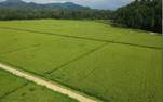 
Figure 10 GIES
ground station in Liuhe County
|
To improve the effective traceability of rice
growth environment and cultivation processes, automatic observation stations
for rice habitats have been constructed. Adopting a low‑power low-power
internet of things (IoT) sensing system, the stations can monitor,
automatically identify and continuous record 10 targeted observation
parameters in real time, including landscape video, air temperature, air
humidity, air quality, wind speed and wind direction (Figure 10).
6 Discussion and Conclusion
Case studies confirm that the
soil in the volcanic plateau of Liuhe County is derived from basalt weathering
and rich in potassium, calcium, magnesium, phosphorus and other minerals and
trace elements. These soil properties provide a continuous and stable
nutritional supply for rice growth, laying a solid foundation for the high
yield and superior quality of rice cultivated on volcanic ash substrates.
Meanwhile, the irrigation water originates from natural spring water of the
Changbai Mt.
Naturally filtered through volcanic rock strata, the water is clean, clear and
mineral-rich, with all indicators better than the national standard for
farmland irrigation water, which fundamentally ensures a pure and safe growth
environment for rice and highlights the natural advantages of Liuhe rice.
Taking ecological protection as the principal base of
regional development, Liuhe County has established an integrated sustainable
development system encompassing precise habitat management, eco-friendly
cultivation practices, standardized whole-process production, brand-oriented
operation, traceability management by science and technology, as well as rice
culture inheritance, thereby realizing the organic integration of ecological,
economic and social benefits. The findings indicates that volcanic ash
substrate constitutes the core endowment for the high nutrition and safety of
Liuhe rice; strict habitat protection serves as the fundamental premise for the
sustainable development of the rice industry; standardized production, brand
operation and digital management act as critical approaches to enhance product
value.
The development model of Liuhe rice industry
effectively embodies the ecological development philosophy of China. It not
only promotes quality improvement and efficiency growth of local geographical
indication products, but also provides a replicable and popularizable typical
model for the protection and utilization of characteristic agricultural
products in the Changbai Mt. and other volcanic rock areas nationwide, the high‑quality
development of geographical indication products, and the implementation of the
rural revitalization strategy.
Author Contributions
Zhao, L. was
responsible for the overall design of the study, conducting investigations,
sampling, data collation, and manuscript writing. Yue, Y. X. provided overall
guidance. Shi, Y. offered guidance on rice cultivation. Meng, X. J. offered
guidance on ecological environment analysis. Zhang, Q. offered guidance on the
production and management analysis of Liuhe rice and assisted in connecting
with farmers. Gao, J. Y. created the spatial maps. Wei, J. X. collected and
processed samples. Gu, X. H., Dong, J. W. and Tao, Y. coordinated the
investigations. Tang, D. W. and Li, B. were responsible for investigations,
sampling, and data collection. Qin, Z. S. and Zhao, Z. Z. were responsible for
video production. The other authors participated in data collection. All
authors contributed to the discussion of the manuscript.
Acknowledgements
We thank Professors Wang, Z. B., Liu, C., Song, X. F.,
and Fu, J. Y. from the Institute of Geographic Sciences and Natural Resources
Research, Chinese Academy of Sciences, for their guidance and assistance in the
project initiation and research roadmap development of this case study.
Conflicts
of Interest
The authors
declare no conflicts of interest.
References
[1]
Fu, J. Y., Du, X. L., Zheng, Q.
S., et al. GIES case dataset on rice permanent farmland in Lanjia
Village, Jilin Province of China [J]. Journal of Global Change Data
& Discovery, 2021, 5(3): 275–289. https://
doi.org/10.3974/geodp.2021.03.06.
[2]
Zhao, L., Gao, J. Y., Wei, J.
X., et al. GIES case dataset on Liuhe rice permanent basic farmland
[J/DB/OL]. Digital Journal of Global Change Data Repository, 2026.
https://doi.org/10.3974/ geodb.2026.04.03.V1.
[3]
GCdataPR Editorial Office. GCdataPR data sharing
policy [OL]. https://doi.org/10.3974/dp.policy.2014.05 (Updated 2017).
[4]
State Administration for Market
Regulation, Standardization Administration of China. Standard for irrigation
water quality (GB 5084—2021) [S]. Beijing: China Environment Publishing Group,
2021.
[5]
Ministry of Ecology and
Environment of P. R. China, State Administration for Market Regulation. Soil
environmental quality risk control standard for soil contamination of
agricultural land (Trial) (GB 15618—2018) [S]. Beijing: China Environment
Publishing Group, 2018.
[6]
Chen, Y. Newly approved rice
varieties in Jilin Province [J]. Rural Scientific Experiment, 2014(1): 8–13.
[7]
Tang, B. G., Chen, D. B., Luo,
P., et al. Multi-location planting performance and high-yield
cultivation techniques of national-approved three-line indica hybrid rice
Quanyou Huazhan [J]. Agricultural Science and Technology Communication,
2020(12): 243–245.
[8]
National Health Commission of
P. R. China, State Administration for Market Regulation. National food safety
standard—maximum levels of contaminants in food (GB 2762—2022) [S]. Beijing:
Standards Press of China, 2022.
[9]
Liuhe County, Jilin Province.
Refining a single industry to enrich local people: high-quality grain projects
boost high-value development of Liuhe rice [J]. China Grain Economy,
2020(10): 24–25.