GIES
Case Study on Fusong Quanyang Mineral Water Basalt Lava Forestry
BIAN Jianmin1* WANG Ding2 WANG Fan1 LI Yining1 SUN Xiaoqing1 LI Yihan1 WANG Gang2 GAO Jiantang3 DU Yuchuan3 ZHANG Jiaming4 PAN Xuhui5
LIU Xiangyun5 HUANG
Xiaoyan5 LIU Liankun3
DING Zhiying6 GAO He7
CHEN Shengbo8 WANG
Zhenbo9
1. College
of New Energy and Environment, Jilin University, Changchun 130021, China; 2.
People’s Government of Fusong County, Baishan 134500, China; 3. Fusong County
Market Supervision and Administration Bureau, Baishan 134500, China; 4.
People’s Government of Quanyang Town, Fusong County, Baishan 134500, China; 5.
Jilin Sengong Group Quanyangquan Beverage Co., Ltd., Baishan 134505, China; 6.
School of Pharmacy, Jilin University, Changchun 130021, China; 7.
Hydrogeological Survey Institute of Jilin Province, Changchun 130042, China; 8.
College of Geoexploration Science and Technology, Jilin University, Changchun
130062, China; 9. Institute of Geographic Sciences and Natural Resources
Research, Chinese Academy of Sciences, Beijing 100010, China
Abstract:
Quanyang Town, situated in Fusong County, is situated within
the basaltic plateau and primeval forest hinterland of the Changbai Mt., Jilin
Province, constitutes a representative area for the occurrence, extraction, and
utilization of natural mineral water in the Changbai Mt. region. The study
region covers approximately 589.84 km2 and administratively includes 10 villages and 6
communities. In 2023, the total population is 26,372, with an urban population
of 23,332. The Quanyangquan mineral water resource
is notable for its abundant recharge, favorable hydrogeological occurrence
conditions, and substantial resource volume. Environmental analyses reveal that
the area is located within a north temperate continental monsoon climate zone.
The distinctive basaltic geological structure, combined with extensive forest
cover, weakly acidic soils rich in organic matter, and vigorous deep
groundwater circulation, collectively promote precipitation infiltration and
water-rock interactions, ensuring the stable formation of mineral water. The
mineral water is primarily weakly alkaline (pH 7.2–7.5) and is characterized by
low sodium content
(4.28 mg/L), low mineralization, and elevated metasilicic acid concentrations
(ranging from 18.3 to 28.1 mg/L, with 28.1 mg/L in the final product), fully
complying with the China standard for drinking natural mineral water (GB
8537—2018). The hydrochemical facies are
predominantly of the HCO3‒–Ca·Mg type. Sustained by deep groundwater recharge, the water
source demonstrates long-term stability in both yield and quality.
Additionally, the surrounding aquatic environment exhibits a pristine
hydrochemical background, marked by low salinity and minimal heavy metal
concentrations, indicative of a favorable ecological condition. The quality of Quanyangquan
mineral water derives from regional climate, geology, vegetation and soil,
while source protection, spatial control and standardized production support
its green brand and sustainability. The dataset is archived in .shp, .tif, .xlsx and .docx
formats, and consists of 89 data files with data size of 110 MB (compressed
into 1 file with 10.5 MB).
Keywords: Changbai
Mountain; Quanyangquan mineral water; Quanyang Town; basaltic plateau; GIES;
Case 34
DOI: https://doi.org/10.3974/geodp.2026.03.07
Dataset Availability Statement:
The dataset supporting this paper
was published and is accessible through the Digital Journal of Global Change Data Repository
at: https://doi.org/10.3974/geodb.2026.03.07.V1.
1 Introduction
Amid
the ongoing transformation of consumer preferences and the intensifying
emphasis on health-oriented hydration, natural mineral water has evolved from a
traditional commodity into a valuable resource distinguished by its ecological integrity,
quality standards, and brand identity. Recent national policies, including the
“Healthy China” initiative and the promotion of “Ecological Civilization”, have
underscored the importance of high-quality utilization of regional specialty
resources. These policies advocate for comprehensive, lifecycle-based
management approaches encompassing upstream ecosystem preservation, rigorous
quality assurance, brand development, and cross-industry collaboration. Within
this framework, distinctive mineral water resources—shaped by pristine
environmental conditions and stable natural endowments—serve not only as
essential elements in premium drinking water supply chains but also as pivotal
drivers for enhancing the value of ecological products and advancing
sustainable regional development.
Fusong County
constitutes one of the most concentrated and qualitatively representative
regions for natural mineral water resources in China[1–3]. This
concentration results from the synergistic interaction of volcanic geological
structures, forest ecosystems, precipitation recharge dynamics, and minimal
human interference, which collectively have given rise to numerous high-quality
mineral water sources with considerable developmental potential. Preliminary
studies indicate that Quanyang Town source exhibit stable recharge conditions,
substantial resource volumes, and exceptional, long-term water quality
stability. Nonetheless, prior existing research has primarily addressed the
origin, hydrochemical properties, or resource exploitation assessments of
mineral water in the Changbai Mt. area. Consequently, the comprehensive relationships among habitat conditions, environmental
support mechanisms, and the foundational factors influencing product
quality—factors that establish Quanyangquan as a distinguished
geographical product—along with their implications for conservation management,
remain insufficiently explored.
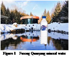 This study targets the mineral water of
Quanyang Town in the Changbai Mt. as a representative case for analysis (Figure
1). By incorporating
multiple dimensions—such
as geological frameworks, geomorphological
attributes, forest vegetation, soil conditions, hydrochemical
This study targets the mineral water of
Quanyang Town in the Changbai Mt. as a representative case for analysis (Figure
1). By incorporating
multiple dimensions—such
as geological frameworks, geomorphological
attributes, forest vegetation, soil conditions, hydrochemical
properties,
and conservation management practices—and utilizing empirical data obtained
through field investigations, sample collection, and laboratory analyses, the
research systematically characterizes the habitat features and their formative
impact on mineral water quality. The aim is to establish an empirical basis for
habitat conservation, quality assessment, and sustainable development of
Quanyangquan, while offering strategic reference for the protection,
utilization, and brand fortification of premium mineral water resources
throughout the Changbai Mt. area.
2 Metadata of the Dataset
The title, authors,
geographic region, year of the data, dataset files, etc. for the GIES case
dataset on Fusong Quanyang mineral water basalt lava forestry[4] are
listed in Table 1.
Table 1 Metadata
summary of the GIES case dataset on Fusong Quanyang mineral water basalt lava
forestry
|
Items
|
Discription
|
|
Dataset full name
|
GIES case dataset
on Fusong Quanyang mineral water basalt lava forestry
|
|
Dataset short
name
|
QuanyangMineralWaterCase34
|
|
Authors
|
Bian, J. M.,
College of New Energy and Environment, Jilin University, bianjm@jlu.edu.cn
Wang, D.,
People’s Government of Fusong County, 236147070@qq.com
Wang, F., College
of New Energy and Environment, Jilin University, fanwang24@mails.jlu.edu.cn
Li, Y. N.,
College of New Energy and Environment, Jilin University,
yining24@mails.jlu.edu.cn
Sun, X. Q.,
College of New Energy and Environment, Jilin University, sunxq13@jlu.edu.cn
Li, Y. H.,
College of New Energy and Environment, Jilin University
Wang, G.,
People’s Government of Fusong County, 364899194@qq.com
Gao, J. T., Fusong
County Market Supervision and Administration Bureau, 84809029@qq.com
Du, Y. C., Fusong
County Market Supervision and Administration Bureau
Zhang, J. M.,
People’s Government of Quanyang Town, Fusong County
Pan, X. H., Jilin
Sengong Group Quanyangquan Beverage Co., Ltd.
Liu, X. Y., Jilin
Sengong Group Quanyangquan Beverage Co., Ltd.
Huang, X. Y., Jilin
Sengong Group Quanyangquan Beverage Co., Ltd.
Liu, L. K., Fusong
County Market Supervision and Administration Bureau
Ding, Z. Y.,
School of Pharmacy, Jilin University
Gao, H.,
Hydrogeological Survey Institute of Jilin Province
Chen, S. B.,
College of Geoexploration Science and Technology, Jilin University,
chensb@jlu.edu.cn
Wang, Z. B.,
Institute of Geographic Sciences and Natural Resources Research, Chinese
Academy of Sciences, wangzb@igsnrr.ac.cn
|
|
Geographical
region
|
Quanyang Town,
Fusong County, Baishan City, Jilin Province
|
|
Year
|
2000–2025
|
|
Data format
|
.shp, .xlsx, .docx,
.jpg
|
|
Data size
|
10.5 MB (compressed)
|
|
Data files
|
Case area
boundary, physical geography data, product characteristic data, socioeconomic
data, etc.
|
|
Foundation
|
Jilin Provincial
Administration for Market Regulation (2025)
|
|
Data Publisher
|
Global Change
Science Research Data Publication System, http://www.geodoi.ac.cn
|
|
Adress
|
No. 11A, Datun
Road, Chaoyang District, Beijing100101, China
|
|
Data sharing
policy
|
(1) Data
are openly available and can be free downloaded via the Internet; (2) End
users are encouraged to use Data
subject to citation; (3) Users, who are by definition also value-added
service providers, are welcome to redistribute Data subject to written permission from the GCdataPR Editorial
Office and the issuance of a Data
redistribution license; and (4) If Data
are used to compile new datasets, the “ten percent principle” should be
followed such that Data records
utilized should not surpass 10% of the new dataset contents, while sources
should be clearly noted in suitable places in the new dataset[5]
|
|
Communication and searchable system
|
DOI, CSTR, Crossref, DCI, CSCD, CNKI, SciEngine, WDS, GEOSS, PubScholar,
CKRSC
|
3 Case Dataset Development
3.1 Case Area
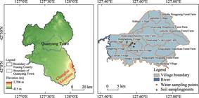
The water source for the Fusong mineral water
case is situated in Quanyang Town, Fusong County, Baishan City, Jilin Province
(Figure 2), at geographic coordinates 127°32′46″E and 42°19′14″N. This source
lies approximately 55 km in a straight line from Tianchi (Heavenly Lake) on
Changbai Mt. and is located about 2 km from the Hun-Bai Railway in terms of transportation distance. Regional
connectivity is enhanced by the proximity of the Heda Expressway (G11) and
National Highway (G201), which run roughly 12 km to the north. Quanyang Town
covers an administrative area of approximately 589.84 km2. According
to statistical data from 2023[6], the town administers 10 villages
and 6 communities, comprising a total of 14,470 households and a population of
26,372, of whom 23,332 reside in urban areas. Fusong County, encompassing
Quanyang Town, is characterized by an extensive hydrological network and
functions as a significant zone for water conservation and mineral water resource concentration within the Changbai Mt. The area is distinguished by high forest coverage and
an unspoiled ecological environment. The principal surface water bodies in the
town include the Lazi and Quanyang Rivers, both tributaries of the Erdao
Songjiang River system. The Quanyang River benefits from numerous spring
inflows along its course, supporting a specialized industrial framework focused
on the extraction and utilization of natural mineral water resources.
|
Figure
2 Geo-location map of the case area and
sampling sites
|
3.2 Climate Conditions
The case area is situated
within a north temperate continental monsoon climatic zone[2].
Meteorological data from the Donggang Station spanning 2000 to 2024 indicate an
average annual temperature of approximately 3.3 ℃, exhibiting marked
seasonal variability with peak temperatures occurring in July and August and
minimum temperatures in January. The mean annual precipitation is around 808.9
mm, with historical maximums reaching 1,071.3 mm; precipitation is predominantly
concentrated between June and August. The average annual potential evaporation
is 1,291.7 mm, accompanied by an annual sunshine duration averaging 2,315.77 h
and a mean wind speed of 2.17 m/s. As depicted in Figure 3, temperature
demonstrates a consistent unimodal annual pattern. Precipitation is primarily
confined to the summer months, during which evaporation rates also increase,
reflecting the characteristic features of a mountainous monsoon climate. This
climatic regime significantly influences the genesis, recharge, and yield of
Quanyangquan mineral water. Firstly, the temporal concurrence of peak
precipitation and elevated temperatures— alongside the fact that summer
precipitation substantially exceeds evaporation—promotes canopy interception by
forest vegetation, regulation of soil moisture, and subsequent infiltration
through basaltic pores and fractures, thereby facilitating effective recharge
to the groundwater recharge. Secondly, although sub-zero winter temperatures
and snow accumulation temporarily inhibit direct infiltration, cryospheric
processes extend the recharge period via spring snowmelt, thereby enhancing the
annual storage and discharge capacity. This climatic pattern— characterized by
concentrated summer recharge and winter cryospheric modulation, serves as a
buffer against short-term meteorological fluctuations, sustaining the stability
of spring discharge and hydrochemical characteristics, and providing a
conducive environment for the continuous production of mineral water.
3.3 Geological Structure
The case area is located within the volcanic province
of the Changbai Mt., where the
regional tectonic frameworks is defined by
multi-directional fault systems, predominantly
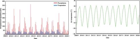
Figure 3 Statistical of average
precipitation, evaporation, temperature in Fusong County (2000–2024)
oriented east-west and
northeast. Extensive Cenozoic volcanic activity has led to the widespread
deposition of basaltic sequences. The primary outcrops correspond to the
Junjianshan Formation (Lower Pleistocene, Quaternary), which is chiefly
composed of massive and vesicular basalts. The presence of well-developed
primary vesicles and contraction joints within these units offers substantial
storage and conduits for groundwater movement. Simultaneously, the regional
fault networks function as preferential pathways facilitating deep groundwater
circulation and mineral water discharge. The regional
topography exhibits a northwestward descending stepped physiography originating
from the Changbai Mt. volcanic massif. This
interplay between basaltic plateaus and topographic gradients establishes
favorable hydrodynamic conditions that promote groundwater flow through pores, fractures, and
fault zones. Consequently, groundwater emerges as prolific spring clusters at
topographic depressions or lithological barriers. Mineralogically, the basalts
are predominantly composed of plagioclase and pyroxene. These rocks are
characterized by elevated concentrations of SiO2, Al2O3,
and TFe[3], and are enriched in components such as CaO, MgO, Na2O,
and K2O. The incongruent weathering of these primary minerals supplies
a continuous influx of Ca2+, Mg2+, Na+, and
HCO3‒ ions to
the soil-groundwater system.
Mineral spring recharge in Fusong County is primarily
controlled by atmospheric precipitation[3], with a considerable
fraction of the groundwater undergoing extended deep circulation that enhances
water-rock interactions. Throughout its migration, the groundwater persistently
leaches silicate minerals from the basaltic host rock; this process, driven by
the involvement of CO2 involvement and carbonate dissolution,
progressively leads to the formation of metasilicic acid mineral water
characterized by low mineralization and a dominant HCO3‒–Ca·Mg
(calcium-magnesium bicarbonate) hydrochemical facies[7]. As a major
mineral water source in Fusong County, Quanyangquan is notable for its stable
recharge regime, consistent hydrochemical characteristics, and substantial
resource capacity, making it a highly representative example of the region’s
mineral water resources.
3.4 Topography
The case area is located on
the volcanic lava plateau of the Changbai Mountain[3]. The regional
topography generally slopes downward from east to west, with geomorphological
features predominantly comprising basaltic plateaus, mid-mountain slopes, and
river valleys. Within this region, the plateau surfaces are relatively level,
punctuated by localized volcanic cones. River valleys exhibit a trough-shaped
morphology, while the
edges
of the plateau margins are marked by significant fluvial incision. Consequently, the area demonstrates a distinct
physiographic gradient transitioning from elevated plateaus to slopes and
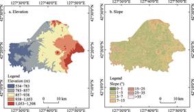
valleys. Utilizing 12.5-m resolution ALOS PALSAR DEM data,
the elevation and slope characteristics of the case area were classified and
analyzed (Figure 4). Findings reveal that elevations predominantly range
between 700 and 1,000 m, encompassing 87.03% of the total area. Slope analysis
indicates that the terrain is mainly gentle and flat; with slopes under 7°
accounting for 80.70% of the region; notably, the 3°–7° represents the largest
proportion at 35.82%. The Quanyangquan spring is located at approximately 750 m
elevation, situated within a mid-to-low elevation zone characterized by
relatively gentle topography. This geomorphological context facilitates
effective capture of upgradient recharge and convergence of groundwater flow,
thereby supporting stable spring discharge.
|
Figure
4 Elevation and slope classification
maps of Quanyang Town
|
Concerning the hydrogeological conditions conducive to
mineral water formation, the case area is predominantly characterized by lava
plateaus and gently sloping terrains within low to mid-elevation mountainous
areas. This physiographic setting promotes the gradual infiltration of
atmospheric precipitation, a process moderated by the buffering effects of
dense forest cover and topsoil—thereby facilitating effective groundwater
recharge. Additionally, the topographic gradient provides the gravitational
force necessary for groundwater migration through basaltic pores, fractures,
and fault zones, channeling flow
toward zones of concentrated
discharge at mid to lower elevations. This topographic progression—encompassing
recharge in higher
elevations, subsurface migration along gentle slopes and structural
discontinuities, and stable discharge in lower-lying areas—constitutes a
fundamental framework supporting the sustained recharge, consistant yield, and
extensive water-rock interactions characteristic of the Quanyangquan mineral
water system.
3.5 Vegetation Conditions
|
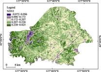
Figure 5 NDVI classification map of Quanyang
Town
|
The case area is characterized by
well-established vegetation, predominantly comprising forested land. It borders
the Changbai Mountain Nature Reserve along its eastern edge and encompasses a
diverse range of forest types. Natural secondary young- and middle-aged stands
constitute a significant portion of the vegetation, with coniferous-broadleaf
mixed forests representing the principal natural forest type, while coniferous
forests predominate among plantation types. Analysis based NDVI data (Figure 5)
reveals a sparse distribution of low-value zones, indicating that vegetation
cover within the case area is both continuous and stable. Bare soil and
anthropogenic disturbances constitute only a minor component of the landscape. The high forest density and uninterrupted
vegetation layers contribute to effective precipitation interception, reduction
of surface runoff, and improved soil water retention[7]. These
processes collectively facilitate the gradual infiltration of precipitation and
enhance the region’s water conservation capacity, thereby establishing a strong
ecological barrier and creating a conducive environment for the recharge and
formation of mineral water.
3.6 Soil Conditions
The predominant soil type
within the case area is Albic soil, characterized by a clay loam to clay
texture and a compact structure. The authors selected 3 representative sites
for soil analysis: forested land adjacent to the water source, forested land
within Quanyang Town, and local agricultural land. At each site, 3 replicate
samples were collected and stratified into surface (0–20 cm) and subsurface
(20–40 cm) layers (Figure 2). These samples were physically homogenized in
equal proportions by layer and subsequently submitted to the Jilin Provincial
Institute of Geological Sciences for detailed analysis. Analytical results indicate that the soil
exhibits a generally weakly acidic, with pH ranging from 5.09 to 5.65 (Table
2). Soil organic matter (SOM) content in the forested topsoil is notably
elevated, reaching a maximum of 93.523 g/kg, whereas the subsurface layer
exhibits a minimum SOM concentration of 20.5 g/kg. In contrast, SOM concentrations
in the farmland layers are 38.13 g/kg and 46.74 g/kg for the surface and
subsurface horizons, respectively. This high SOM content within a weakly
acidic pedological environment effectively increases soil CO2 and facilitates the release of low-molecular-weight
organic acids. Such conditions enhance the chemical weathering of plagioclase
and pyroxene minerals in the basaltic bedrock, thereby promoting the
mobilization of Ca, Mg, Na, HCO3‒, and H2SiO3
into the groundwater system. This biogeochemical process forms the essential
habitat foundation that characterizes Quanyangquan mineral water as a
low-mineralization, calcium-magnesium bicarbonate type. Moreover, the concentrations of heavy metals, including Zn, Cu, and Pb,
remain well below the thresholds established by the national standard Soil
environmental quality risk control standard for soil contamination of
agricultural land (Trial) (GB 15168— 2018)[8], confirming that the
soil in the case area is uncontaminated and maintains a pristine condition.
Table 2 Statistical testing result of principal
soil indicators in Quanyang Town
|
Test item
|
Unit
|
Forest soil S1 (20 cm)
|
Forest soil S1 (40 cm)
|
Forest soil S2 (20 cm)
|
Forest soil S2 (40 cm)
|
Farmland soil S3 (20 cm)
|
Farmland soil S3 (40 cm)
|
Limits[8]
|
|
pH
|
–
|
5.53
|
5.09
|
5.65
|
5.52
|
5.59
|
5.60
|
/
|
|
TN
|
g/kg
|
3.32
|
2.71
|
5.34
|
1.52
|
2.51
|
2.96
|
/
|
|
AP
|
mg/kg
|
22.0
|
12.6
|
24.4
|
13.5
|
32.9
|
24.6
|
/
|
|
AK
|
mg/kg
|
129
|
70.0
|
155
|
56.2
|
167
|
181
|
/
|
|
SOM
|
g/kg
|
54.1
|
41.8
|
93.5
|
20.5
|
38.1
|
46.7
|
/
|
|
Si
|
%
|
29.10
|
29.61
|
29.33
|
32.02
|
30.72
|
30.01
|
/
|
|
Cd
|
mg/kg
|
0.159
|
0.127
|
0.229
|
0.092
|
0.192
|
0.200
|
0.3
|
|
Hg
|
mg/kg
|
0.061
|
0.052
|
0.086
|
0.040
|
0.052
|
0.057
|
1.8
|
|
As
|
mg/kg
|
9.04
|
9.32
|
9.94
|
11.1
|
12.4
|
13.0
|
30
|
|
Pb
|
mg/kg
|
27.8
|
27.1
|
27.8
|
28.5
|
29.7
|
33.0
|
90
|
|
Cr
|
mg/kg
|
75.6
|
73.1
|
78.6
|
74.3
|
81.3
|
85.3
|
200
|
|
Ni
|
mg/kg
|
32.5
|
33.3
|
23.5
|
28.7
|
28.9
|
29.2
|
100
|
|
Cu
|
mg/kg
|
26.8
|
26.8
|
20.5
|
22.0
|
24.0
|
24.0
|
50
|
|
Zn
|
mg/kg
|
112
|
111
|
95.4
|
92.8
|
102
|
114
|
200
|
Note: – indicates no
corresponding data; / indicates no corresponding standard limit.
3.7 Surrounding Water Conditions
In May 2025, water samples were collected by authors from multiple sites,
including the Quanyang River, Erdao Songjiang River, Quanyang Lake, the stream
traversing the Quanyang Spring water source area, and local tap water (Figure 2).
These samples were subsequently analyzed at the Jilin Provincial Institute of
Geological Sciences, with the results presented in Table 3. The pH
across all sampling sites ranged from 6.77 to 7.16, suggesting that the water
was predominantly neutral to slightly alkaline. TDS concentrations varied
between 60 and 145 mg/L, indicative of low mineralization levels. HCO3‒ emerged as the
dominant anion, with concentrations spanning from 29.3 to 65.2 mg/L; notably,
higher concentrations were observed in the Erdao
Songjiang River, while other sites exhibited comparable levels. Cl‒
concentrations were notably low (0.72–3.84 mg/L), and fluoride levels were
measured between 0.10 and 0.12 mg/L. These findings collectively suggest a low
salinity baseline in the regional water bodies and minimal influence from
anthropogenic pollution sources. H2SiO3
concentrations ranged from 18.3 to 26.4 mg/L, with the stream and tap water
from the source area reaching 25.3 mg/L and 26.4 mg/L, respectively. The elevated bicarbonate and low chloride concentrations, alongside
consistent pH and metasilicic acid levels, reflect a stable hydrochemical
environment in the surrounding waters. Importantly, all key parameters in the
surface water samples complied with the national Class I water quality
standards[9]. These results indicate that the area surrounding the
water source maintains a favorable natural hydrochemical background and a
pristine ecological environment, thereby providing conducive external
conditions for the formation and preservation of the natural quality of
Quanyangquan mineral water. Furthermore, the data imply that water source
protection measures and regional environmental management practices are
generally effective.
The concentrations of trace
elements such as Mn, Fe, As, Se, and Sr in water samples collected from the case
area were all markedly below the regulatory thresholds established for
corresponding surface water (GB 3838—2002)[9] or drinking water standards (GB 5749—2022)[10]. Additionally,
heavy metals such as Cd, Pb, and Cr were found to be below the detection
limits. Considering that agricultural activities in Quanyang Town are
predominantly rain-fed and self-sustaining, coupled with the absence of heavy
industrial operations or large-scale high-risk pollutant discharge facilities
in the region, it can be concluded that the baseline water quality in the
vicinity of the case area is of a high standard.
Table 3 Statistical testing result of surrounding
water quality in Quanyang Town
|
Test item
|
Unit
|
Tap water (W1)
|
Erdao Songjiang River (W2)
|
Quanyang Lake (W3)
|
Quanyang River (W4)
|
Source stream (W5)
|
Limits[9]
|
Limits[10]
|
|
pH
|
–
|
7.13000
|
6.77000
|
6.91000
|
7.09000
|
7.16000
|
6-9
|
6.5–8.5
|
|
TDS
|
mg/L
|
60
|
145
|
62
|
60
|
63
|
/
|
≤1,000
|
|
Cl‒
|
mg/L
|
1.07000
|
3.84000
|
0.99000
|
0.82000
|
0.72000
|
≤250
|
≤250
|
|
HCO3‒
|
mg/L
|
32.60000
|
65.20000
|
32.60000
|
32.60000
|
29.30000
|
/
|
/
|
|
H2SiO3
|
mg/L
|
26.40000
|
19.60000
|
18.30000
|
25.50000
|
25.30000
|
/
|
/
|
|
Sr
|
mg/L
|
0.03880
|
0.09970
|
0.03720
|
0.03840
|
0.03560
|
/
|
/
|
|
Se
|
mg/L
|
0.00200
|
0.00300
|
0.00100
|
0.00090
|
0.00200
|
≤0.01
|
≤0.01
|
|
Mn
|
mg/L
|
0.00098
|
0.00108
|
0.00986
|
0.00086
|
0.00115
|
≤0.1
|
≤0.1
|
|
Fe
|
mg/L
|
0.03040
|
0.02170
|
0.14300
|
0.00170
|
0.05810
|
≤0.3
|
≤0.3
|
|
F-
|
mg/L
|
0.12000
|
0.11000
|
0.10000
|
0.11000
|
0.12000
|
≤1.0
|
≤1.0
|
|
Cd
|
mg/L
|
<0.00006
|
<0.00006
|
<0.00006
|
<0.00006
|
<0.00006
|
≤0.001
|
≤0.005
|
|
Pb
|
mg/L
|
<0.00007
|
<0.00007
|
<0.00007
|
<0.00007
|
<0.00007
|
≤0.01
|
≤0.01
|
|
Hg
|
mg/L
|
<0.00007
|
<0.00007
|
<0.00007
|
<0.00007
|
<0.00007
|
≤0.00005
|
≤0.001
|
|
As
|
mg/L
|
0.0003
|
0.0009
|
0.001
|
0.0004
|
0.0003
|
≤0.05
|
≤0.01
|
|
Cr
|
mg/L
|
<0.00009
|
<0.00009
|
<0.00009
|
<0.00009
|
<0.00009
|
≤0.01
|
≤0.05
|
Note: – indicates no
corresponding data; / indicates no corresponding standard limit.
4 Mineral Water Quality Data
4.1 Mineral Water Quality
Historical data[11]
indicate that the pH of the raw water from Quanyangquan generally ranges
between 7.25 and 7.66, indicating midly alkaline conditions. TDS concentrations
are approximately 54–88 mg/L, categorizing the water as a low-mineralized
mineral water. The ionic composition is predominantly characterized by HCO3‒ as the main anion, Ca2+
and Mg2+ serving as the primary cations. The hydrochemical profile
demonstrates considerable stability, with the water classified within the HCO3‒–Ca·Mg hydrochemical
facies. Molar fraction analysis shows that HCO3‒ constitutes roughly 74% of the total anions,
while Ca²⁺ and Mg2+ together account for approximately 66% of the
total cations.
Raw water samples collected from Quanyangquan were
subjected to analysis by the Baishan Product Quality Inspection Institute and
the National Drinking Water Product Quality Supervision and Testing Center. The
results (Table 4) indicate that the H2SiO3 concentration
is 28.1 mg/L, which satisfies the threshold requirements stipulated in the National
food safety standard—drinking natural mineral water (GB 8537—2018)[12], underscoring its significance
as a key diagnostic component of Quanyangquan mineral water. Concurrently, the
Na+ concentration was measured at 4.28 mg/L, while Cl‒
and SO42‒
concentrations were notably low, at 0.80 mg/L and 3.70 mg/L respectively,
reflecting a minimal saline background. F‒ (0.22 mg/L) and NO3‒ (4.96 mg/L)
concentrations remain at minimal levels.
Concerning heavy metals and other contaminants, concentrations
of As, Hg, Cd, Pb, Cr, Sb, Ni, Ba, bromides, borates, volatile phenols,
cyanides, nitrites, and other parameters were all well below regulatory limits[12],
thereby conforming to the relevant quality standards.
Table 4 Statistical testing result of key indicators of Quanyangquan mineral water
|
Test item
|
Unit
|
Testing
result
|
Limits[12]
|
Test item
|
Unit
|
Testing
result
|
Limits[12]
|
|
pH
|
–
|
7.48000
|
/
|
Br‒
|
mg/L
|
<0.005
|
0.01
|
|
Na+
|
mg/L
|
4.28000
|
/
|
BO2‒
|
mg/L
|
0.03000
|
5
|
|
K+
|
mg/L
|
1.55000
|
/
|
Sb
|
mg/L
|
<0.00007
|
0.005
|
|
Ca2+
|
mg/L
|
5.06000
|
/
|
Mn
|
mg/L
|
0.00040
|
0.4
|
|
Mg2+
|
mg/L
|
2.28000
|
/
|
Ni
|
mg/L
|
<0.00007
|
0.02
|
|
Fe2++Fe3+
|
mg/L
|
0.04000
|
/
|
Ba
|
mg/L
|
0.00200
|
0.7
|
|
HCO3‒
|
mg/L
|
33.00000
|
/
|
Cr
|
mg/L
|
0.00020
|
0.05
|
|
CO32‒
|
mg/L
|
<3
|
/
|
Cu
|
mg/L
|
<0.00009
|
1
|
|
Cl‒
|
mg/L
|
0.80000
|
/
|
Ag
|
mg/L
|
<0.00003
|
0.05
|
|
SO42‒
|
mg/L
|
3.70000
|
/
|
Volatile
phenols
|
mg/L
|
<0.0020
|
0.002
|
|
NO3‒
|
mg/L
|
4.96000
|
/
|
CN‒
|
mg/L
|
<0.0020
|
0.01
|
|
H2SiO3
|
mg/L
|
28.10000
|
≥25.0
|
As
|
mg/L
|
0.00020
|
0.01
|
|
Co
|
mg/L
|
<0.00003
|
/
|
Hg
|
mg/L
|
<0.0001
|
0.001
|
|
V
|
mg/L
|
0.00200
|
/
|
Cd
|
mg/L
|
<0.00006
|
0.003
|
|
Al
|
mg/L
|
0.08000
|
/
|
Pb
|
mg/L
|
<0.00007
|
0.01
|
|
F‒
|
mg/L
|
0.22000
|
≤1.5
|
NO2‒
|
mg/L
|
<0.0033
|
0.1
|
|
Se
|
mg/L
|
0.00100
|
0.05
|
BrO3‒
|
mg/L
|
<0.005
|
/
|
Note: – indicates no
corresponding data; / indicates no corresponding standard limit.
4.2 Product Feature Comparison
Based on comparisons with
internationally renowned mineral waters, the mineral water produced in Quanyang
Town is of exceptional quality (Table 5)[13–16].
Table 5 Comparison of the water quality of
Quanyangquan mineral water with the world-renowned
mineral waters Unit: mg/L
|
Brand name
|
Origin
|
K+
|
Na+
|
Mg2+
|
Ca2+
|
HCO3‒
|
SO42‒
|
H2SiO3
|
|
Quanyangquan
|
Fusong, China
|
1.55
|
3.31
|
3.13
|
7.13
|
33.41
|
3.13
|
26.79
|
|
Volvic
|
Auvergne, France
|
6.2
|
11.6
|
8
|
11.5
|
371
|
8.1
|
41.2
|
|
Evian
|
French Alps
|
1.1
|
7
|
27.6
|
82
|
375
|
12
|
18
|
|
Vittel
|
France
|
4.9
|
7.5
|
20.6
|
95.9
|
267
|
122
|
10.9
|
|
Perrier
|
Southern France
|
0.4
|
10.6
|
3.6
|
159
|
430
|
32
|
13.1
|
|
Gerol
|
Eifel Volcanic, Germany
|
2.8
|
11.1
|
49.5
|
137
|
427
|
45
|
17.1
|
Basaltic fissure and pore-water systems are extensively
distributed throughout the Fusong area of the Changbai Mt., with the
aquifers in Quanyang Town demonstrating notably high water-yielding capacities[17,18].
The hydrochemical profile of Quanyangquan mineral water closely resembles that
of the internationally recognized Volvic brand from the French Alps; however,
its metasilicic acid concentration is markedly higher than that of other well- known
mineral waters[13]. The overall mineralization remains at a low
level, distinguished by an exceptionally low sulfate concentration, which
mitigates the bitternesstypically associated with elevated sulfate content.
High-quality mineral water must meet both physiological health standards[19]
and sensory acceptability. In this investigation, the palatability of
Quanyangquan was quantitatively evaluated using the O Index developed by
Hashimoto[20,21]. The analysis produced an O Index of 5.8,
significantly surpassing the criterion for “delicious water” (O Index≥2.0).
Furthermore, the 17O-NMR full width at half maximum (FWHM), an indicator
of water cluster structure, was determined to be 78 Hz. This measurement aligns
closely with the cluster structure observed in Evian mineral water and falls
well within the recognized range for natural premium drinking waters (70–90
Hz). Accordingly, the taste quality of Quanyangquan is classified as
“excellent”.
5 Socioeconomic Development and Industrial
Development
5.1 Socioeconomic Development
In 2023, Fusong County
reported a GDP of 11.519 billion CNY[6], reflecting a year-on-year
increase of 5.5% at constant prices. The value added by the primary, secondary,
and tertiary sectors was 2.616 billion CNY, 1.755 billion CNY, and 7.148
billion CNY, respectively. This distribution corresponds to a sectoral composition
ratio of 22.7:15.2:62.1, indicating a predominantly tertiary-sector-driven
economy characterized by the integrated development of ecological resource
utilization and the service industry. The township recorded a total of 14,470
households and a population of 26,372 in 2023, of which 23,332 were urban
residents, demonstrating a notably high urbanization rate within the township.
Leveraging its advantageous forest ecological
environment and resource endowments within the hinterland of the Changbai Mt. hinterland, Quanyang Town has adopted a strategic development
focus on forest-based foods products, mineral water extraction, and ecological
services. The Jilin Provincial Government has officially recognized “Quanyang
Forest Food Town” as a provincial-level characteristic industrial township.
Consequently, Quanyang Town benefits from a solid industrial foundation and
favorable policy support, positioning it well for the sustainable development
of regional specialty resources and the promotion of green industrial sectors.
5.2 History and Culture
The Fusong mineral water,
situated in Quanyang Town, lies at the core of the volcanic lava plateau within
Changbai Mt. The nomenclature of this water source derives from
extensive long-term observations of the natural habitat; specifically, the
Quanyang River— historically known as the Quanyan River—is formed by the
confluence of 8 major mineral spring clusters. Due to the consistent discharge
and stable temperature of these springs throughout the year, the river remains
unfrozen even during the harshest winter months, thereby creating a distinctive
landscape characterized by the juxtaposition of “white mountains and black
waters”. Upon the establishment of the Quanyang Forestry Bureau was established
in 1959, the area was officially designated as “Quanyang”, reflecting the
bureau’s location north of the Quanyan River and adhering to the
traditional Chinese convention whereby the northern side of a river is termed
as “Yang”. A local proverb encapsulates this phenomenon: “In the depths of
winter, the mountains are blanketed in white, while the spring river flows
black”. This adage vividly illustrates the unique properties of the water
source: wherein the the river remains unfrozen and exhibits a deep black hue,
resembling a dark ribbon winding meandering through the snow-laden forest. This
is not only a natural wonder of the Changbai Mt. but also reflects
the earliest observations by local residents regarding the water’s high
stability and exceptional quality. Moreover, the water source area region
substantially overlaps with the Changbai Mt. ginseng
cultivation area, thereby providing an unpolluted and pristine environment
conducive to the growth of ginseng and other rare medicinal plants.
5.3 Mineral Water Resources Development
Recent data from 2024 reveal that the annual
runoff of Fusong mineral water in Quanyang Town amounts to 1.93×10⁶
t (calculated on a 365-day basis). Currently, Jilin Sengong Group Quanyangquan
Beverage Co., Ltd. has largely attained continuous year-round production. The
company’s mining permit authorizes an annual extraction capacity of 8×10⁶
t, representing the highest approved volume among mineral water enterprises in
the Changbai Mt. region. Actual annual extraction approximates
7×10⁶ t, with total water usage for production reaching 7.89×10⁶
t during the most recent operational period (June 2023 to May 2024). Thus, the
permitted extraction volume constitutes only 41.42% of the total annual runoff,
indicating considerable potential for expansion in both extraction and
production. Within the broader context of mineral water development in Fusong
County, the Quanyang Town source area exhibits a distinct competitive advantage
in production capacity. Its authorized extraction volume is 12 times greater
than that of the Xiagu Spring and 6 times that of the Xianren Spring,
accounting for 78.4% of the company’s total capacity within Fusong County. This
substantial resource endowment underpins supply stability, facilitates capacity
enhancement, and supports market growth, thereby affirming the site’s status as
a representative core sample area.
5.4 Sustainable Development of Quanyangquan Mineral
Water
According to the Quanyang
Town territorial space and urban planning, construction activities are
predominantly concentrated within established urban centers and along
transportation corridors. Conversely, areas adjacent to mineral water sources
retain a substantial proportion of forested land and ecological connectivity,
creating a spatial configuration that effectively separates development and
construction from water source protection zones. Simultaneously, the town’s
industrial composition is largely characterized by low-pollution sectors,
including forestry, service industries, and mineral water extraction, while
agricultural practices are mainly reliant on rain-fed methods. This combination
contributes to a relatively low level of anthropogenic disturbance overall.
Such a spatial arrangement—marked by the dominance of ecological spaces
alongside concentrated human activities—fosters favorable environmental
conditions that support stable groundwater recharge and ensuring long-term
water quality safety.
The Quanyang Town Wastewater Treatment Plant has
maintained stable operational performance, consistently producing effluent that
complies with Class 1 A standards. In 2023, the facility treated a total volume
of 2.384×10⁶ m3 of wastewater, achieving effluent concentrations of COD at
10.3 mg/L and NH3–N
at 0.95 mg/L. Furthermore, all generated sludge, amounting to 80.89 t disposed
in 2023, was disposed of safely, resulting in a 100% disposal rate. This
comprehensive sludge management effectively mitigates the potential leaching
hazards associated with sludge accumulation along the riverbank.
5.5 Industry and Brand Development
Capitalizing on the superior
mineral water resources of Changbai Mt., Fusong County,
in recent years, consistently prioritized the mineral water industry as a
strategic focus within its green food sector and distinctive resource-based
economy. The county has advanced this sector by intensifying efforts in
resource exploration and assessment, safeguarding water sources, attracting and
nurturing projects, and developing industrial parks. This comprehensive
approach has facilitated the gradual establishment of an industrial development
model characterized by leading enterprises and coordinated supply chain collaboration. By October
2021, the county’s mineral water beverage production reached 9.47×10⁵
t, 830 million CNY, and 150 million CNY, respectively. In 2023, these figures
increased substantially, with production rising to 1.42×10⁶ t,
output value to 1.5 billion CNY, and combined profits and taxes totaling 267
million CNY[6]. Among the prominent enterprises in the region,
Quanyangquan stands out as leading brand in Jilin Province, having received
accolades such as the “China Famous Brand” and “China Well-Known Trademark”, as
well as being designated the inaugural “Changbai Mt. Ecological Food”
brand. Through sustained efforts in market expansion, channel development, and
brand promotion, Quanyangquan has transformed from a regional drinking water
brand into a nationally recognized high-quality natural mineral water brand
rooted in Northeast China.
5.6 Ecological Environment Traceability for
Quanyangquan Mineral Water
|
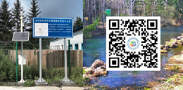
Figure 6 GIES ground station in Quanyang
Town
|
In order to facilitate
near-real-time monitoring of the mineral spring habitat, the Fushong Quanyangquan
mineral water GIES ground station was established in May 2025 at the the water
source in Quanyang Town, Fusong County (Figure 6). This station employs a
low-power IoT sensing system designed to continuously monitor and record
various regional meteorological variables—including air temperature,
precipitation, wind speed and direction, relative humidity, and atmospheric
pressure—alongside habitat specific parameters such as soil
temperature, soil moisture content, and soil electrical conductivity. The
collected data are transmitted in real time for ongoing analysis.
6 Discussion and Conclusions
The Fusong mineral water
located in Quanyang Town originates within the basaltic plateau of the Changbai
Mt. and is influenced by the integrated effects of
multiple environmental factors. Precipitation, topography, geological
structures, and vegetation cover collectively facilitates deep groundwater
circulation and ensures stable spring discharge. Additionally, the presence
of organic-rich soils promotes ion release and the accumulation of distinctive
chemical constituents. The water exhibits an HCO3‒–Ca·Mg hydrochemical facies, characterized by weak alkalinity, low mineralization, low sodium,
and high metasilicic acid content, maintaining superior and stable quality.
Water source protection, spatial management, and standardized production
are the essential pillars for its sustainable development.
Although this study has elucidated the synergistic
contributions of precipitation, vegetation, soil, and geological substrates to
mineral water formation, the context of global climate change and frequent
extreme weather events underscore the necessity for establishing a long-term
dynamic monitoring network. This will provide a more robust scientific
foundation for precise water resource assessments. The Fusong mineral water
source area in Quanyang Town currently holds a significant advantage in
production capacity, with authorized extraction volumes substantially
surpassing those of adjacent sources. As production scales up, it is
imperative to continuously monitor anthropogenic activities within and
surrounding the case area, adhere to green production practices, and promote
ecological conservation in tandem with corporate growth. The economic benefits
derived should be reinvested into ecological protection initiatives, low-carbon
technological advancements, and public science education. By deepening the
exploration of the water source’s historical-cultural heritage and promoting
healthy drinking water concepts, the natural environmental assets can be
transformed into high-value-added green brand capital, positioning Quanyangquan
as a benchmark for ecological product development.
Author
Contributions
Bian, J. M., Wang, F., Li, Y .N., Li, Y. H., Sun, X. Q.
and Chen, S. B. designed the dataset and drafted the paper; Bian, J. M., Wang,
F. and Li, Y .N. collected soil and water samples and conducted the tests;
Wang, D., Wang, G., Gao, J. T., Du, Y. C., Zhang, J. M., Pan, X. H., Liu, X.
Y., Huang, X. Y., Liu, L. K. and Gao, H. provided and processed critical
monitoring data related to the survey, development, and production of the
Quanyang Spring, as well as socioeconomic and demographic data for Quanyang
Town; Ding, Z. Y. provided feedback on the water quality and health sections of
the data paper. Wang, Z. B. oversaw the study design, team coordination, and
quality control.
Acknowledgements
We would like to express our
gratitude to the leaders at all levels of Fusong County for their support and
cooperation, as well as to the staff who assisted in the collection of water
and soil samples and the gathering of related data. We also extend our thanks
to Professors Liu, C., Song, X. F. of the Institute of Geographic Sciences and
Natural Resources Research, Chinese Academy of Sciences, for their guidance
during the project approval process and in the review and revision of the
dataset and paper!
Conflicts of Interest
The
authors declare no conflicts of interest.
References
[1]
Gao,
Y. Study on recharge conditions and formation mechanism of mineral water in
Fusong County [D]. Changchun: Jilin University, 2016.
[2]
Li, H.
Y., Sun, Y. H., Lu, L. L., et al. Analysis of water resources
characteristics of drinking water source protection areas in Fusong [J]. Jilin
Geology, 2013, 32(3): 80–85.
[3]
Lin, L. Study on the origin and development control of
mineral water resources in Changbai Mountain area [D]. Changchun: Jilin University, 2016.
[4]
Bian,
J. M., Wang, D., Wang, F., et al. GIES case dataset on Fusong Quanyang
mineral water basalt lava forestry [J/DB/OL]. Digital Journal of Global Change Data
Repository,
2026. https://doi.org/10.3974/geodb. 2026.03.07.V1.
[5]
GCdataPR Editorial Office.
GCdataPR data sharing policy [OL]. https://doi.org/10.3974/dp.policy.2014.05
(Updated 2017).
[6]
Office of the Baishan Municipal Local Chronicles
Compilation Committee. Baishan Yearbook (2024) [M]. Changchun: Jilin Literature
and History Press, 2024.
[7]
Dai,
C. Study on evaluation of water resources development and utilization level and
optimal allocation in Changbai Mountain mineral water concentration area [D].
Changchun: Jilin University, 2022.
[8]
Ministry
of Ecology and Environment of P. R. China, State Administration for Market
Regulation. Soil environmental quality risk control standard for soil
contamination of agricultural land (Trial) (GB 15618—2018) [S]. Beijing: China
Environment Publishing Group, 2018.
[9]
State Environmental Protection Administration,
General Administration of Quality Supervision, Inspection and Quarantine of P.
R. China. Environmental quality standards for surface water (GB 3838—2002) [S].
Beijing: China Environmental Science Press, 2002.
[10]
State Administration for Market Regulation,
National Standardization Administration. Standards for drinking water quality
(GB 5749—2022) [S]. Beijing: Standards Press of China, 2022.
[11]
Li, D.
Origin of metasilicate mineral water in basaltic area of Changbai Mountain: experimental
study of water-rock reaction kinetics [D]. Changchun: Jilin University,
2022.
[12]
National
Health Commission of P. R. China, State Administration for Market Regulation.
National food safety standard—drinking natural mineral water (GB 8537—2018)
[S]. Beijing: Standards Press of China, 2018.
[13]
SGS
Fresenius Institute. Testing and evaluation report on natural mineral water of
Changbai Mountain, Jilin Province, China [R]. 2005.
[14]
Ma,
Q., Han, L. N., Zhang, J. Q., et al. Environmental risk assessment of
metals in the volcanic soil of Changbai Mountain [J]. International Journal
of Environmental Research and Public Health, 2019, 16(11): 2047.
[15]
Zhang,
H. R., Liang, X. J., Dong, Y., et al. Hydrochemical characteristics and
formation mechanism of natural mineral water in Fusong County [J]. Water
Resources and Power, 2020, 38(4): 55–59.
[16]
Li, Y.
H., Bian, J. M., Li, J. L., et al. Hydrochemistry and stable isotope
indication of natural mineral water in Changbai Mountain, China [J]. Journal
of Hydrology: Regional Studies, 2022, 40: 101047.
[17]
Pinzaru,
S. C., Ardeleanu, M., Brezestean, I., et al. Biogeochemical specificity
of adjacent natural carbonated spring waters from Swiss Alps promptly revealed
by SERS and Raman technology [J]. Analytical Methods, 2019, 11(6):
801–812.
[18]
Lai,
Q. F. Study on ecological base flow and mineral water in Changbai Mountain
basalt area [D]. Changchun: Jilin University, 2019.
[19]
Wang,
Y. Study on the characteristics and genesis of hot springs and mineral water in
the northwest of Changbai Mountain [D]. Beijing: China University of
Geosciences (Beijing), 2020.
[20]
Yin,
J., Zhang, X. Y., Wang, J. H., et al. Analysis of quality
characteristics of natural mineral water in Changbai Mountain region [J]. Water
Purification Technology, 2008, 27(6): 58–61.
[21]
Yan,
B. Z., Xiao, C. L., Liang, X. J., et al. Influences of pH and CO2
on the formation of metasilicate mineral water in Changbai Mountain, Northeast
China [J]. Applied Water Science, 2017, 7(4): 1657–1667.