Three Glacial Lakes Change Data at the Foot of
Mt. Everest, Himalaya
Chen, W. B.1* Fukui, H.2 Doko, T.1 Liu, C.3 Feng, Q.4 Gou, P.5 Shi, R. X.3
1. Keio Research Institute at SFC, Keio University, Fujisawa 2520882, Japan;
2. Chubu Institute for Advanced Studies, Haruhirai 361000, Japan;
3. Institute of Geographic Sciences and Natural Resources Research, Chinese Academy of Sciences, Beijing 100101, China;
4. Institute of Remote Sensing and Digital Earth, Chinese Academy of Sciences, Beijing 100101, China;
5. Institute of Tibetan Plateau Research, Chinese Academy of Sciences, Beijing 100101, China
Abstract: The Himalaya is the most extensively glacierized region in the world, other than the polar regions. It is also a sensitive region to climate change. Changes of glacial regime become one of indicators of climate change. The three glacial lakes, which are Rongbuk Lake (China), Karda Lake (China), and Imja Lake (Nepal), at the foot of Mt. Everest were time-series analyzed. The dataset of the glacial lakes were produced in Arc/GIS (.shp) and Google Earth (.kmz) formats using the remote sensing imageries integrated with DEM data. The attribute of dataset includes period, name, area, sensor, and location. The result showed that Rongbuk Lake did not exist in 1976 until its area reached to 580,239 m2 by 2014; the area of Karda Lake increased from 389,317 m2 in 1976 to 809,388 m2 in 2014; and the area of Imja Lake expanded from 284,411 m2 in 1976 to 1,260,218 m2 in 2014.
Keywords: glacial lake data; Rongbuk Lake; Karda Lake; Imja lake; Mt. Everest
1 Introduction
Known as the third polar of the world in climate change, the Himalayas play an important role in the regional climate dynamics. Since the second half of the 20th century, numerous glaciers in the Himalayan region have retreated due to climate changes[1–6]. The glaciers retreating directly influenced the glacial lake formation and expansion. The changes of glacial lakes could be one of indicators of climate changes. Thus, time-series monitoring the changes of glacial lakes would efficiently illustrate the regional climate changes.
However, because of large spatial scale, remoteness[7], high altitude, and atrocious weather[8] in the Himalayan region, physically to access to the region and measuring the changes are the primary challenges for conducting scientific researches. Therefore, remote sensing technique is an effective method to accomplish those arduous tasks. The authors developed the time-series dataset of three glacial lakes at the foot of Mt. Everest using a conventional method based on field survey and remote sensing (see Figure 1). Becuase of the different periods, the data of the Landsat MSS in 1976, the Landsat TM in 1992, the Landsat ETM+ in 2000, the ASTER in 2008, the DigitalGlobe in 2014, and the ASTER GDEM were used for this study. This dataset (Three Glacial lakes (Rongbuk, Karda, Imja) Change data at the Foot of Mt. Everest, Himalaya. “GL_RKI”) could be used as the reference to the research on global change in the Himalayan region. At the same time, the dataset would be valuable as a historic dataset for long-term study of regional environment changes.
|
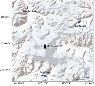
Figure 1 Location of the three glacial lakes
|
These dataset[9] are fundamental for the two published research papers by Chen, W. B., Doko, T., Fukui, H., et al., Changes in Imja Lake and Karda Lake in the Everest Region of Himalaya. Natural Resources, 2013, 4: 449-455[11], and Chen, W. B., Doko, T., Liu, C., et al, Changes in Rongbuk Lake and Imja Lake in the Everest region of Himalaya. Int. Arch. Photogramm. Remote Sensing Spatial Information Sciences, 2014, (XL-2): 259-266[12].
2 Metadata of Dataset
The GL_RKI dataset[9] is summarized in Table 1. It includes the dataset full name, short name, authors, geographical centroid coordinate, year of the dataset, data format, dataset and data files, data publisher, data access and services platform, and data sharing policy.
3 Methodology for the Dataset Development
The methodology to produce the dataset was developed and illustrated in the two published papers[11–12]. Here, we summarize the main methodology for the dataset development from those published papers.
3.1 Dataset Development
To develop the dataset included satellite imageries selection and processing, modeling the glacial lakes identification, creating the spatial database, editing the attribute database, field survey both on the southern and northern slopes of Mt. Everest, and data comparative
analysis in different periods, etc. Figure 2 presents the flowchart of the glacial lake dataset development.
Table 1 Metadata summary of the GL_RKI dataset
|
Items
|
Description
|
|
Dataset full name
|
Three glacial lakes (Rongbuk, Karda, Imja) change data at the foot of Mt. Everest, Himalaya
|
|
Dataset short name
|
GL_RKI
|
|
Authors
|
Chen, W. B. L-5715-2016, Keio Research Institute at SFC; Keio University, chenwb3@gmail. com
Fukui H. D-3797-2017, Chubu Institute for Advanced Studies, fukui@isc.chubu.ac.jp
Doko T. L-6494-2016, Keio Research Institute at SFC; Keio University, dokochan@ sfc.keio.ac.jp
Liu, C. L-3684-2016, Institute of Geographic Sciences and Natural Resources Research, Chinese Academy of Sciences, lchuang@igsnrr.ac.cn
Feng, Q. D-6727-2017, Institute of Remote Sensing and Digital Earth, Chinese Academy of Sciences, fengqiang@radi.ac.cn
Gou, P. L-6876-2016, Institute of Tibetan Plateau Research, Chinese Academy of Scien-
ces, goupeng@itpcas.ac.cn
Shi, R. X. L-4389-2016, Institute of Geographic Sciences and Natural Resources Research, Chinese Academy of Sciences, shirx@ignsrr.ac.cn
|
|
Geographical centroid coordinate
|
Rongbuk Lake: 86°51′47″E, 28°6′48″N
Karda Lake: 87°2′51″E, 28°4′7″N
Imja Lake: 86°55′21″E, 27°53′54″N
|
|
Year
|
1976, 1992, 2000, 2008, 2014
|
|
Data format and size
|
.shp, .kmz, .rar; data size: 728.4 KB, data compressed size: 444 KB
|
|
Data files
|
The dataset consists of two files:
The dataset of three glacial lakes (Rongbuk, Karda, Imja) changes. It consists of three compressed files: Rongbuk.rar, 302KB; Karda.rar, 52.7 KB; Imja.rar, 89.4 KB. Each compressed file contains ARC/GIS (.shp) format and Google Earth (.kmz) format
Two filed survey documentary files: 1) field work in Himalaya, Nepal (Chen_Imja_2008.pdf); 2) naming and forming of Rongbuk Lake (Liu_Rongbuk_2012.pdf)
|
|
Data publisher
|
Global Change Research Data Publishing & Repository, http://www.geodoi.ac.cn
|
|
Address
|
No. 11 A, Datun Road, Chaoyang District, Beijing 100101, China
|
|
Data sharing policy
|
Data from the Global Change Research Data Publishing & Repository includes metadata, datasets (data products), and publications (in this case, in the Journal of Global Change Data & Discovery). Data sharing policy includes: (1) Data are openly available and can be free downloaded via the Internet; (2) End users are encouraged to use Data subject to citation; (3) Users, who are by definition also value-added service providers, are welcome to redistribute Data subject to written permission from the GCdataPR Editorial Office and the issuance of a Data redistribution license; and (4) If Data are used to compile new datasets, the ‘ten per cent principal’ should be followed such that Data records utilized should not surpass 10% of the new dataset contents, while sources should be clearly noted in suitable places in the new dataset[10]
|
3.2 Data Sources and Processing
3.2.1 Data Sources
Satellite imageries with minimal obstruction by clouds and snow coverage were used in this study (see Table 2). These imageries were the Landsat MSS in December 1976 with a spatial resolution of 60 m, the Landsat TM in November 1992 with a spatial resolution of 30 m, the Landsat ETM+ in October 2000 with a spatial resolution of 30 m, the ASTER in January 2008 with a spatial resolution of 15 m, and the Digital Globe in 2014 with a spatial resolution of 1 m. For the terrain analysis, ASTER Global DEM data were downloaded from the ASTER GDEM website.
3.2.2 Pre-processing of Time Series Remote Sensing Data
Since the satellite imageries merely present the digital number (DN), it was needed to convert to the top of atmosphere (TOA) reflectance in order to calculate the NDWI which was conducted using reflectance data. Different time period data used different resolution.
Table 2 Summary of satellite imageries
|
Sensor
|
Date
|
Path
|
Row
|
Resolution (m)
|
No. of bands
|
|
MSS
|
Dec. 19, 1976
|
150
|
41
|
60
|
4
|
|
TM
|
Nov. 17, 1992
|
140
|
41
|
30
|
7
|
|
ETM+
|
Oct. 30, 2000
|
140
|
40/41
|
30
|
8
|
|
ASTER
|
Jan. 6, 2008
|
140
|
115/116
|
15
30
90
|
3 (1-3)
6 (4-9)
5 (10-14)
|
|
Digital Globe
(Google Earth)
|
Apr. 8, 2014 Rongbuk Lake
May 18, 2014 Karda Lake
Dec. 18, 2014 Imja Lake
|
-
|
-
|
1
|
|
|
ASTER GDEM
|
2009
|
-
|
-
|
30
|
1
|
Note: original MSS pixel size was 79 ´ 57 meters; production systems resample the data to 60 meters.
3.3 Modeling the Glacial Lakes Identification
3.3.1 NDWI Calculation
The NDWI (normalized difference water index) was calculated to allow identification of water bodies from the satellite imageries. NDWI is defined as the difference of reflectance observed in the green band and the NIR band divided by the sum of the two reflectance
values[13]. The equation was presented below:
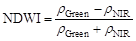 (1)
(1)
where ρGreen and ρNIR are reflectance in green and near infrared bands, respectively.
3.3.2 Slope Calculation
A model of the terrain was developed from a digital elevation model (DEM) derived from the ASTER GDEM data. Based on our previous field work in the Himalaya and Tibet, China, it was recognized that the angle of inclination that allowed drainage of melt water had gradients greater than 10°. Study in Bhutan[14] and study in China and Nepal[15] reported similar observations. Thus, a threshold value of a ground angle of 10° (maximum) was adopted in this study.
In the end, the boundaries of the glacial lakes were identified by integrating the NDWI and angle of inclination criteria. The satellite imagery analysis and data processing were performed using ENVI® 4.7, to convert from raster data of glacial lakes to vector data of glacial lakes and to edit attribute database were performed using ArcMAP® 10.
3.4 Field Work on Imja Lake and Rongbuk Lake
During April and May of 2008, there was a fieldwork on Imja Lake which was located on the southern slope of Mt. Everest, Nepal. The leader was Prof. Fukui financed by Ministry of Education, Culture, Sports, Science & Technology (MEXT), Japan. From May to June in 2012, there was a fieldwork on Rongbuk Lake, which was located on the northern slope of Mt. Everest, China, leaded by Prof. Liu and financed by Chinese Academy Sciences (CAS) and Asia-Pacific Network for Global Change Research (APN). The purpose of the fieldworks were to validate the modeling of glacial lakes development, and collect geographic information associated with glacial lakes development. These geographic information could be useful for the research on glacial lakes expansion and global climate change responses in the Himalayan region.
|
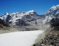
Figure 3 Imja Lake taken on May 1st, 2008
(photographer: Chen, W. B.)
|
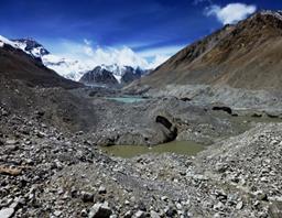
Figure 4 Rongbuk Lake taken on Jun. 1st, 2012 (photographer: Chen, W. B.)
|
4 Results
The results were embodied in three data files. They are: 1) data of Rongbuk Lake from 1992 to 2014 (Rongbuk.rar); 2) data of Karda Lake from 1976 to 2014 (Karda.rar); and 3) data of Imja Lake from 1976 to 2014 (Imja.rar). There are two type data formats, which are Arc/GIS (.shp) and Google Earth (.kmz), in the compressed files.
The result showed that Rongbuk Lake did not exist in 1976 until its area reached to 580,239 m2 by 2014; the area of Karda Lake increased from 389,317 m2 in 1976 to 809,388 m2 in 2014; and the area of Imja Lake expanded from 284,411 m2 in 1976 to 1,260,218 m2 in 2014. The surface areas among the three glacial lakes in 1976, 1992, 2000, 2008, and 2014 were summarized in Table 3. The result analysis will be explained in another file.
Map comparison showed the changes of the three glacial lakes (see Figure 5, Figure 6, and Figure 7).
Table 3 Time-series changes among the three glacial lakes
|
Year
|
Area (m2)
|
|
Rongbuk Lake (China)
|
Karda Lake (China)
|
Imja Lake (Nepal)
|
|
1976
|
NA
|
389,317
|
284,411
|
|
1992
|
3,051
|
550,732
|
567,360
|
|
2000
|
124,576
|
623,236
|
724,365
|
|
2008
|
509,381
|
684,966
|
894,881
|
|
2014
|
580,239
|
809,388
|
1,260,218
|
|
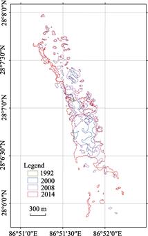
Figure 5 Rongbuk Lake changes
(Rongbuk Lake was born in 1992)
|
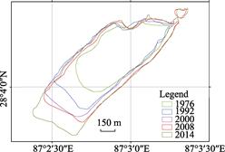
Figure 6 Karda Lake changes
|
|
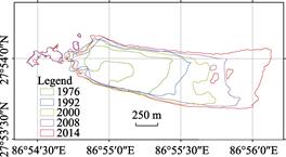
Figure 7 Imja Lake changes
|
| |
|
|
|
|
Author Contributions
Fukui, H. designed and organized the field work in Imujia Lake, Nepal in summer of 2008. Chen, W. B. and Fukui, H. participate the field work in Imujia Lake in 2008. Liu, C. designed and organized the field work in Rongbuk Lake, China in May–June 2012. Liu, C., Chen, W. B., Feng, Q. and Gou, P. participated the field work in Rongbuk Lake of China in 2012. Doko, T. participated the field work in Xining-Lhasa-Namtso of the Tibet Plateau. Chen, W. B. completed the data pre-processing and analysi, Doko, T., Shi, R. X., Feng, Q. and Gong, P. participated the data analysis. Feng, Q. and Gong, P. made the detail arrangement for the field work in Rongbuk Lake in 2012. Chen, W. B. drafted the data paper, Liu, C., Fukui, H. and Doko, T. checked the dataset and reviewed the paper.
Acknowledgement
The authors appreciate that the MEXT financed the fieldwork in 2008 on Imja Lake. Nagoya University, Chubu University, AIT, and ICIMOD joined the fieldwork. The authors would like to thank the supports from Institute of Geographic Sciences and Natural Resources Research, CAS and Qumulangma station of Institute of Tibetan Plateau Research, CAS, and financed by APN and Prof. Li Guoqing from Institute of Remote Sensing and Digital Earth, Chinese Academy of Sciences organized the fieldwork on Xining, Lhasa and Namtso. Prof. Zhou, X. et al. participated the fieldwork in 2012.
References
[1] Dyurgerov, M. Mountain and subpolar glaciers show an increase in sensitivity to climate warming and intensification of the water cycle [J]. Journal of Hydrology. 2003, 282: 164-176. DOI: 10.1016/S0022- 1694(03)00254-3.
[2] Shrestha, A. B., Kumar, R., Shen, Y. An Overview of Glaciers, Glacier Retreat, and Subsequent Impacts in Nepal, India and China [M]. In: Thomas, K. J., (ed). WWF Nepal Progra. Gland: World Wide Fund for Nature (WWF), 2005.
[3] Bajracharya, S. R., Mool, P. K., Shrestha, B. R. Impact of climate change on Himalayan Glaciers and Glacial Lakes: case studies on GLOF and Associated Hazards in Nepal and Bhutan [R]. Kathmandu: International Centre for Integrated Mountain Development (ICIMOD), 2007.
[4] Immerzeel, W. W., Droogers, P., de Jong, S. M., et al. Largescale monitoring of snow cover and runoff simulation in Himalayan river basins using remote sensing [J]. Remote Sensing of Environment, 2009, 113(1): 40-49. DOI: 10.1016/j.rse.2008.08.010.
[5] Owen, L. A., Robinson, R., Benn, D. I. et al. Quaternary glaciation of Mount Everest [J]. Quaternary Science Reviews, 2009, 28(15/16): 1412-1433. DOI: 10.1016/j.quascirev.2009.02.010.
[6] Kaltenborn, B. P., Nellemann, C., Vistnes, I. I. High mountain glaciers and climate change-Challenges to human livelihoods and adaptation [OL]. Available at: http://www.unep.org/publications/contents/pub_
details_search.asp?ID=4168. Birkeland: United Nations Environment Programme (UNEP), 2010.
[7] Bishop, M. P., Shroder, J. F. Geographic information science and mountain geomorphology [OL].
Available at: http://www.springer.com/earth+sciences+and+geography/geographical+information+systems /book/978-3-540-42640-0. Springer, 2004.
[8] Barry, R. G. Mountain Weather and Climate [M]. Cambridge: Cambridge University Press, 2008.
[9] Chen, W. B., Fukui, H., Doko, T., et al. Three Glacial lakes (Rongbuk, Karda, Imja) change data at the foot of Mt. Everest, Himalaya [DB/OL]. Global Change Research Data Publishing & Repository, 2014. DOI: 10.3974/geodb.2014.02.05.V1.
[10] GCdataPR Editorial Office. GCdataPR data sharing policy [OL]. DOI: 10.3974/dp.policy.2014.05 (Updated 2017).
[11] Chen, W., Doko, T., Fukui, H., et al. Changes in Imja Lake and Karda Lake in the Everest Region of Himalaya [J]. Natural Resources, 2013, 4: 449-455.
[12] Chen, W., Doko, T., Liu, C., et al. Changes in Rongbuk Lake and Imja Lake in the Everest region of Himalaya [J]. Remote Sensing Spatial Information Sciences, 2014, (XL-2): 259-266, DOI: 10.5194/ isprsarchives
-XL-2-259-2014.
[13] McFeeters, S. K. The use of the Normalized Difference Water Index (NDWI) in the delineation of open water features [J]. International Journal of Remote Sensing, 1996, 17(7): 1425-1432. DOI: 10.1080/ 01431169608948714.
[14] Reynolds, J. M. On the Formation of Supraglacial Lakes on Debris-Covered Glaciers [M]. In Nakawo, M., Raymond, C. F., Fountain, A., (eds). Workshop on Debris-Covered Glaciers. Seattle, Washington, USA: International Association of Hydrological Sciences (IAHS), 2000, 153-161.
[15] Quincey, D. J., Richardson, S. D., Luckman, A., et al. Early recognition of glacial lake hazards in the Himalaya using remote sensing datasets [J]. Global and Planetary Change, 2007, 56(1/2): 137-152. DOI: 10.1016/j.gloplacha.2006.07.013.