Global Change Data Encyclopedia
Bolshevik Island
Qiu, Y. N.1 Xu,
Y. C.1 Zhang, F.1* Liu, C.2* Shi, R. X.2
1. School
of Earth Sciences, Zhejiang University??Hangzhou 310027, China
2.
Institute of Geographic Sciences and Natural Resources Research, Chinese
Academy of Sciences, Beijing 100101, China
Keywords: Bolshevik Island; Russia; Arctic Ocean; Kara Sea; 2015; data
encyclopedia
Dataset Availability
Statement:
The dataset
supporting this paper was published and is accessible through the Digital Journal of Global Change Data
Repository at: https://doi.org/10.3974/geodb.2020.03.16.V1.
Bolshevik Island[1]
is located between Kara Sea and Laptev Sea in the Arctic Ocean. It is the
southernmost and second largest island in Severnaya Zemlya of Russia[2‒3].
The Bolshevik Island is 55 km separated from the Taymyr Peninsula in the
mainland of Asia by Vilkitskogo Strait in the south, and 19 km separated from
the October Revolution Island by Shokalsky Strait in the northwest. The
Bolshevik Island is administered by the Krasnoyarsk Krai of Russia.
The geo-location of the Bolshevik Island
is between 77??55??12??N and 79??25??44??N, 99??23??12??E and 105??27??42??E, the area of
the Bolshevik Island is 11,296.45 km2 in Albers projection. The
coastline is 883.49 km in Lambert projection[4] (Figure 1-2).
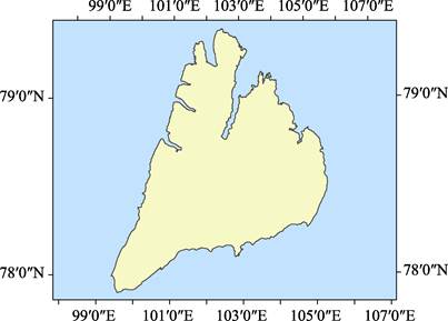
Figure 1 Map of the Bolshevik Island (.shp format)
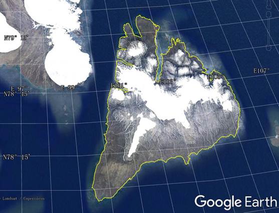
Figure 2 Map of the Bolshevik Island (.kmz format)
The weather is very cold on the island. About 30% of the island is
covered by glaciers. The narrow coastal plain is covered with moss and lichen.
Most of the coastline is relatively straight, and there are some fjords on the
northwest coast of the island. Polis Vernesky discovered the island in 1913,
but it was not proved until George Ushakov and Nikolai Urfanchev made maps of
the island during their 1930‒1932 expedition[3].
The dataset was
developed based on the global multiple scale shorelines dataset based on Google
Earth Images (2015)[5‒6], and
maps of Russia[2]. The dataset is consisted of 15 data files and
archived in .kmz and .shp data formats with the data size of 1.24 MB
(Compressed to 883 KB in two data files).
References
[1]
Editorial Team of Handbook of
Global Geographical Names. Handbook of Global Geographical Names [M]. Beijing:
SinoMaps Press; Surveying and Mapping Press, 1999.
[2]
SinoMaps Press. Atlas of Russia
[M]. Beijing: SinoMaps Press, 2000.
[3]
Wikipedia. Bolshevik Island
[Z]. https://en.wikipedia.org/wiki/Bolshevik_Island.
[4]
Qiu, Y. N., Xu, Y. C., Zhang,
F., et al. Bolshevik Island [J/DB/OL]. Digital Journal of Global Change Data Repository, 2020. https://doi.org/10.3974/geodb.2020.03.16.V1.
[5] Liu, C., Shi, R. X., Zhang, Y. H., et al. Global multiple scale shorelines dataset based on Google
Earth images (2015) [J/DB/OL]. Digital Journal
of Global Change Data Repository, 2019. https://doi.org/
10.3974/geodb.2019.04.13.V1.
[6]
Liu, C., Shi, R. X., Zhang, Y.
H., et al. 2015: How many islands
(isles, rocks), how large land areas, and how long of shorelines in the world?
??Vector data based on Google Earth images [J]. Journal of Global Change Data & Discovery, 2019, 3(2): 124?C148. https://doi.org/10.3974/geodp.2019.02.03.