Progress of Dragon Programme (Phase 4) Between European Union and China
Wu, J. F.* Yao, W. Q. Li, P. F.
College of Geomatics, Xi’an University of Science and Technology, Xi’an 710054, China
The Dragon Programme is a cooperation program between European Space Agency (ESA) and the Ministry of Science and Technology (MOST) of P. R. China, which was launched in 2004. There were four phases up to 2018 with each phase lasting for four years. The latest and newest phase, the Dragon Programme (Phase 4) commenced in July 2016 in Wuhan city of China at the Dragon Programme launch symposium. The new phase in the cooperation brings 28 joint Sino-European teams together to investigate the following topics: atmosphere, climate & carbon cycle; agriculture, food & water; urbanization & smart cities; ecosystems including forest and grasslands; oceans & coastal zones; solid earth & associated disaster risk reduction; hydrology and cryosphere; and calibration/validation.
To study and exchange the progress and results of the Dragon Programme (Phase 4) achieved in the past two years, formulate the next phase of the research plan, and promote the development and progress in the field of remote sensing applications in China and the EU, the Mid-term Results Symposium of Dragon Programme (Phase 4) was held in Xi’an, China, during 18–22 June, 2018. The international symposium was jointly sponsored by the Ministry of Science and Technology of China (MOST) and the European Space Agency (ESA), and organized by the National Remote Sensing Center of China (NRSCC), the Xi’an University of Science and Technology (XUST), and Earth Observation Department of the European Space Agency.
The opening ceremony of the symposium (Figure 1) was co-chaired by Dr. Wang, Qi’an (Director of the National Remote Sensing Center of China), Dr. Karl Bergquist (Director of External Relations Department of the European Space Agency), and Prof. Zhou, Xiaode (Secretary General Department of Science and Technology of Xi’an University). Dr. Zheng, Shimin (Science and Technology Counsellor of the International Cooperation Department of the Ministry of Science and Technology of China), Dr. Zhang, Songmei (Deputy Director of National Remote Sensing Center of China), Prof. Li, Deren and Gong, Jianya (Academicians from Wuhan University), Dr. Li, Zengyuan (Principle Investigator of the Dragon Programme in China), Dr. Yves-Louis Desnos (Principle Investigator of the Dragon Programme in ESA), and Dr. Maurice Borgeaud (Director of Earth Observation Science Application and New Technology department of European Space Agency) took part in the symposium. Nearly 300 scientists and young scholars are involved in the project of the Dragon Programme (Phase 4).
At the meeting, the representatives from China and the European Union (EU) highly recognized the achievements of the Dragon Programme (Phase 4), and agreed that the Dragon Programme (Phase 4) not only expanded the application of remote sensing technology, but also achieved a number of high-level research results.
|
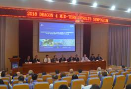
Figure 1 Symposium opening
|
Prof. Li, Zengyuan, Dr. Yves-Louis Desnos, Mr. Eric Doyle, and Dr. Andy Zmuda (the European Project Officers), and Prof. Gao, Zhihai (the Chinese Project Officer), jointly presented on Interim Progress Report of the Dragon Programme (Phase 4) and introduced the achievements achieved in the past two years.
Dr. Maurice Borgeaud, Director of the European Space Agency, delivered speech on ESA Earth Observation Programme, and Dr. Klaus Zeher on Sentiel-5P programme.
Prof. Li, Deren’s presentation at the opening ceremony of the symposium was on Recent EOS activities in China. He introduced the Airborne SAR/InSAR, GF-3 Satellite—the First Multipolarization SAR of China, and Luojia 1a, 1b and 1c satellites from Wuhan University. He summarized that:
1. China has made great progress in high resolution earth observation satellites and their applications in recent decade;
2. EOS including HRS applications in China is helpful for the economic construction and the improvement of living quality efficiently;
3. The international cooperation in EOS like Dragon program will support the sustainable development of China, as well as the world else;
4. Four Right Services should be provided through the cooperation, which is the right Data/Information/Knowledge to the right person at the right time and right place.
Prof. Liu, Yi from the Institute of Atmospheric Physics, Chinese Academy of Sciences, made a thematic report on China’s carbon satellite achievements. He introduced the TanSat mission of the global carbon dioxide science experiment satellite supported by the National High-tech Research and Development Programs of the Ministry of Science and Technology of China and the Strategic Priority Research Program of the Chinese Academy of Sciences. Results show that TanSat is at the same level as that of Australia, Finland, and other developed countries, and it has great significance for China to grasp the changing patterns of global warming and the global carbon emissions’ distribution, and to enhance China’s international voice in addressing global climate change.
The symposium included the Team Meetings, Parallel Splinter Workshops, Plenary Session, Dragon and Young Scientists Poster Session, Bilateral Meeting of ESA & NRSCC and the Shenzhen Ocean & Coastal Training Course.
The Team Meetings were convened by each project on June 19. Each group summarized the results achieved in the past two years since the launch of the project, discussed and revised the report submitted to the conference, and jointly formulated the implementation plan for the next year, including research content, technical routes, needs of remote sensing data, field surveys, team composition, young scholars training, and annual plans.
There were 98 posters displayed at the symposium. These posters showed the progress and high-level results made in the cooperation research of each project in Dragon programme in the past two years. This exhibition and exchange activities encouraged the enthusiasm of young scientists to participate in the program (Figure 2).
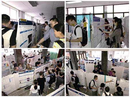
Figure 2 Young scientists poster session
Bilateral Meeting of ESA & NRSCC was held in the morning of 20 June, which focused on the preparation of the advanced training courses on ocean & coastal regions, the exchange and training for young scholars from China and the EU, data sharing, and the organization of the next annual symposium and training course.
Thematic reports on mid-term results, including five subforums: Atmosphere/Climate and Carbon Cycle, Oceans and Coastal Zones, Hydrology and Cryosphere, Solid Earth and Disaster Risk Reduction, and Land-Ecosystems/Smart Cities and Agriculture, were organized in 20–21 June. The Dragon Programme (Phase 4) has 27 projects and 76 collaborative research topics. A total of 111 reports were exchanged at the symposium.
In the morning of June 22, 28 project leaders summarized successively the use of data over the past two years, the content of research, the training and exchange of young scholars, the publication of papers, and the next research plans. They also put forward many useful suggestions for strengthening cooperation, deepened exchanges among scholars in various fields, and were highly praised by the participants.
WS1 Atmosphere/Climate and Carbon Cycle
Philippe Goryl, et al. reported briefly on the following aspects: (1) Exploring new technology and algorithms for high accuracy on-orbit radiometric CAL/VAL of Sino-EU optical remote sensing satellites; (2) Improving and validating algorithms for the calibration of microwave payloads; (3) Establishing a data base of MAXDOAS-based reference fiducial, so as to monitor the NO2, SO2, and HCHO columns and profiles accurately in Eastern China. Plans for the next two years: (1) Improving the calibration accuracy and completing the error budget of Baotou Site; (2) Exploring new technology (spaceborne radiometric benchmark transfer calibration, lunar calibration) for high accuracy on-orbit radiometric CAL/VAL of EO remote sensing satellites; (3) Temperature and humidity retrievals based on microwave observations and simulation and applied in the case study on hurricane; (4) Validation and calibration between European TROPOMI/Sentinel-5P and Chinese EMI/GF-5; (5) improving satellite atmospheric retrieval algorithm.
Li, Ying, et al. based on geostationary satellites MSG/SEVIRI, and Himawari-8/AHI Data, AVHRR Data and MODIS data for AOD acquisition, GA-BP ANN model and physical method for PM2.5 acquisition, the following results are obtained: (1) Long-term, high spatial-temporal resolution AOD has been retrieved for further application study; (2) PM2.5 concentration retrieved by the physical and ANN methods has certain accuracy; (3) Annual average PM2.5 in central and eastern China show a gradual decreasing trend during 2007-2016; (4) Accuracy of some data source is not high yet, which limits the PM2.5 retrieval accuracy. In the future, more data might be applied to the study.
Ma, Yaoming, et al. mainly carried out research in the following four areas: (1) Climate change trend and vegetation greening on the Qinghai-Tibet Plateau; (2) Estimation of land surface parameters from RS; (3) Land surface heat fluxes on the Qinghai-Tibet Plateau and surrounding regions; (4) Modeling on surface parameters. The corresponding results were obtained.
WS2 Oceans and Coastal Zones
Eduard Makhoul, et al. introduced the techniques for sea ice parameter extraction and sea ice monitoring using new satellite data; data application of new satellite altimeters and SWIM, and sea surface salinity algorithm based on combined active/passive microwave imagers. The main findings include: (1) Establishment of a machine-learning-based CryoSat-2 sea ice charting method; (2) Development of a fully automatic multi-scale sea ice drift detection method which has a faster computation speed and higher ice drift vector resolution than pattern matching and feature tracking methods (Sentinel-1); and (3) Data validation of Sentinel-3 SRAL and HY-2A RA, and eddy observation capability in mid-scale of Sentinel-3 SRAL.
Bertrand Chapron, Yang, Jingsong, et al. introduced the results as follows: (1) Algorithm for advanced wind and wave products from multi-sensors; (2) Global features of wind and wave from long term multi-sensor data; (3) Extreme ocean event monitoring from multi- sensors. They plan to focus on multi-source fusion method to analyze ocean storms and waves from different SAR missions.
The team of Stefan SIMIS mainly focus on the following research on:
(1) Synergistic ocean color observation based on polar-orbiting and geostationary satellite images: 1) Validate suspended particulate matter (SPM) from polar orbiting and geostationary satellite images; 2) Develop SPM retrieval from synergistic utilization of polar orbiting and geostationary satellite images; 3) Characterize spatiotemporal patterns and variability of SPM in the Bohai Sea.
(2) Wetland monitoring using high resolution remote sensing images in the Yellow River estuary: 1) Estuarine wetland classification using hyper-spectral remote sensing imagery; 2) Estuarine wetland carbon storage monitoring using hyper-spectral remote sensing imagery; 3) Estuarine wetland morphologic change monitoring using high resolution remote sensing images.
Li, Xiaoming, et al. reported the development of marine-meteo parameter retrieval algorithms/methods from spaceborne SAR (Sentinel-1 and GF-3), and made a detailed evaluation and preliminary test of nonlinear retrieval. Three application cases were introduced.
WS3 Hydrology and Cryosphere
Yao, Tandong, et al. introduced the background structure of the Earth Observation studies of the characteristics and changes of the Alpine Asian cryosphere, and completed the snow depth detection method through TPIS MODIS by going to the study area and collecting the latest data.
Liu, Hui, et al. monitored the dynamics of cryosphere over HMA using multi methods and evaluated its effect on the hydrology in the upstream basin. Results are as follows: (1) SAR backscattering is more sensitive to vegetation regeneration than NDVI; (2) C wave is more sensitive to permafrost vegetation regeneration than L wave; (3) it takes about 5 years for vegetation restoration in the Anak Tuuk River Basin.
Jerome Colin, et al. carried out a number of studies on Water resource behavior and wetland biodiversity in the middle reaches of the Yangtze River, such as monitoring water level, geomatics of wetland, and biodiversity value analysis. In the aspect of a new earth observation tool for the study on biogeochemistry and watershed lakes, they studied the spatiotemporal analysis of hydrological dynamics and biogeochemistry, and developed the EO model and system tool for managing and monitoring the ecology of lakes in the Yangtze River Basin.
Alain Geiger, et al. introduced Calibration and validation of Soil Moisture GNSS Remote Sensing Data and Calibration and Verification of Snow Water GNSS Remote Sensing Data, and proposed a semi-empirical SNR model for soil moisture retrieval using GNSS SNR data. They will further consider the snow data in areas with complicated terrains and combine the BUAA model and ETH model for the analysis.
WS4 Solid Earth and Disaster Risk Reduction
Joaquim J. Sousa, Liu, Guang, et al. mainly used multi-band SAR and lidar data for glacier motion recognition, landslide dynamic monitoring, Longnan geological disaster risk investigation, multiple geological disaster monitoring, etc., and illustrated how to use the advanced multi-source Earth observation technology for landslide identification. They also summarized the theory and method of geological disaster monitoring and risk assessment.
Antonio Pepe, et al. monitored and explained the temporal evolution of the offshore environment through integrated techniques such as DInSAR, GPS, and geophysical surveys. They deduced the submerged area and wave field caused by storm surge using satellite images and offshore water data, and predicted the risk of sea level rise and potential inundation in coastal areas.
Bi, Yaxin, et al. modified the new data analysis method of CUSUM-EWMA and Fuzzy-Inspired, and realized preliminarily the seismic anomaly monitoring system. By analyzing 3T Swarm and 6T satellite data, they detected the seismic anomalies in China, Peru, and Greece. They compared the natural and artificial signals observed by CSELF, established the background model of electric field and magnetic field, and realized the seismic analysis of Jiuzhaigou by combining Swarm satellite and CSELF.
Stefano Tebaldini, et al. reported the following aspects of InSAR deformation estimation: (1) Generated high quality DEM in mountainous areas using multi-baseline/multi-track InSAR data; (2) Monitored dynamically the deformation of Urban land subsidence and public transport infrastructure, and captured the precursory signals of accelerated motion; (3) Proposed a new adaptive robust TomoSAR method for robustness, and monitored the forest area; (4) Retrieved the height of tropical rainforest trees using P-band data and analyzed their time-related effects; (5) SAR Tomography Method and Application Prospect
Liu, Guang, et al. confirmed the effectiveness of multi-source EO technology through a large number of cases, which had an important impact in many applications. In the future, with the increase of data sources, the spatial and temporal processes of geological disasters and their factor analysis and modeling will be deeply studied.
Zeng, Qiming mainly introduced some cases of monitoring North Korea’s nuclear tests, earthquakes and landslides using InSAR technology, proposed InSAR time series method based on GACOS, classified the land coverage using polarimetric SAR data, and explained and prospected the method of 3D tomography SAR imagination.
WS5 Land-Ecosystems/Smart Cities and Agriculture
Costas Cartalis, et al. carried out research on urban scope extraction and continuous monitoring of urban change based on Sentinel-1 SAR and Sentinel-2 MSI data, and monitored the change of urban land cover using PolSAR radar satellite and passive microwave sensor.
Fan, Jinlong, et al. mainly introduced the progress in crop mapping using Sentinel-2A data, and strengthened and improved the compatibility of Sentinel/GF and Proba-V/FY3 MERSI data with the European.
Stefano Pignatti, et al. introduced a method of machine learning regression algorithm to retrieve biophysical parameters, and evaluated effectively the protein content of winter wheat using the regression method between area index and spectral index. In addition, they have realized related work such as exploration, monitoring and simulation of crop pests and diseases, combining multi-source earth observation data (MODIS, TM, ZY, GF, Sentinel data, etc.), meteorological data, and historical data,.
Gabriel del Barrio, et al. mainly used multi-source optical remote sensing technology to detect vegetation restoration characteristics and soil characteristics in arid regions, including estimation of vegetation coverage and NPP, estimation of soil organic matter and soil texture (sand, silt, clay), and effects of vegetation degradation on soil organic carbon storage in arid areas, and developed a set of remote sensing data preprocessing tools based on Sentinel-2 data and maps of vegetation and soil properties.
The specific results of the conference are as follows:
(1) The joint research results from the Dragon Programme (Phase 4) during the past two years were summarized in an all-round way.
This symposium gave a multi-directional and in-depth report and discussion on the cooperation results obtained in the Dragon Programme (Phase 4) about different application fields and technologies of remote sensing through the reports and posters. It has achieved the purposes of mutual exchanges, mutual learning, mutual inspiration, and the integration of different academic views. The cooperation team of the Dragon Programme (Phase 4) completed the relevant scientific research tasks as scheduled and achieved research results, promoting the improvement of China’s remote sensing technology.
(2) Enhanced the academic exchanges and cooperation between China and the EU
This symposium is a gathering of academic exchanges in remote sensing technology between China and the EU. At the conference, scientists from both sides spoke freely and expressed fully their academic views on major scientific issues. There were disputes and affirmation, and the purpose of academic exchange was achieved. At the same time, this symposium also provided another opportunity for China-EU scientists to exchange ideas. Through this exchange, we have enhanced mutual understanding, deepened the collaboration, and strengthened the foundation for cooperation between Chinese and European scientists.
(3) Formulated the work plan for the next step
1) 2019 Dragon Programme (Phase 4) will take place during June 24–28, Ljubljana, Slovenia. Scholars and scientists are invited sincerely to participate in the conference.
2) A training course on marine remote sensing will be held at Shenzhen University and a joint meeting of officers from both sides and PIs of each project will be held at Shenzhen, China.
3) Data and knowledge sharing of China’s carbon satellite data will be promoted actively under the framework of Dragon Programme (Phase 4).