Global Change Data Encyclopedia
Viti Levu, Fiji
Guo, C. F.1*
Li, D. L.1 Zhang,
W.1 Liu, C.2 Shi, R. X.2
1. Liaoning Normal University, Dalian 116029, China;
2. Institute of Geographic Sciences and Natural Resources
Research, Chinese Academy of Sciences, Beijing 100101, China
Keywords: Viti Levu; Fiji;
volcanic island; sucrose; World geography; Data Encyclopedia
The
Viti Levu, located in the southwestern Pacific Ocean, is the largest island in
Fiji. It faces the Koro Sea to the east, the Republic of Vanuatu to the west,
78.84 km from Kadavu Island to the south, and 63.28 km from Vanua Levu to the
northeast. The meaning of its name is "Great Fiji". Suva is the capital
and main port city of Fiji, located on the southeast coast (Figure 1). In terms
of administrative division, Viti Levu is divided into the central and western
regions, with eight provinces: Rewa province, Netahiri province, Namoxi province,
Serua province, La province, Ba province, Nadrojanoosa province and Telavu province[1].
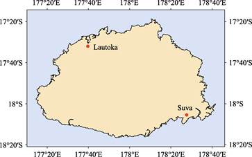
Figure
1 Map of Viti Levu (.shp format)
According to the data of Viti Levu developed
from remote sensing images provided by Google Earth system (Figure 2)., the geographical
location of Viti Levu is 17??18??40??S?C 18??16??34??S, 177??14??35??E?C178??41??46??E. The
area of the Viti Levu is 10,648.88 km2, and the coastline is
1,025.87 km[2]. The island is a tropical maritime climate, with
frequent hurricanes, an average annual temperature of 26?C27 ºC and annual precipitation of 1,800 mm[3].
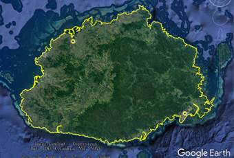
Figure 2 Map of Viti Levu (.kmz format)
The Viti Levu is a volcanic island,
divided by a central mountain range and several extinct volcanoes, all covered
with tropical rain forests. The highest point is mount Tomania on mount
Victoria, 1,324 m above sea level, which is also the highest point in Fiji. The
Nava River, Rewa River and Singha deltas in the eastern part of the island are
fertile, with rice, pineapple, and tobacco grown in valleys. The west is an
important source of sugar, and Lautoka, on the north-west coast, is a port for
sugar-cane plantations, mainly for export. The total population of the island
is about 580,000 (2019), accounting for more than 70% of the country??s
population, mainly made up of Indians and Melanesians[3].
The
dataset was developed based on the ??Global multiple-scale shorelines dataset based
on Google Earth images (2015)??[4], and maps and references related
to Viti Levu. The dataset is consisted of 23 data files and archived in .kmz
and .shp data formats with a data size of 2.81 MB (Compressed to 1.12 MB in three
files).
References
[1]
China Map
Publishing House. Fiji, Tonga and Tahiti [M]. Beijing: China Map Publishing
House, 2018.
[2]
Guo, C. F.,
Li, D. L., Zhang, W. Viti Levu [DB/OL]. Global Change Data Repository, 2020.
DOI: 10.3974/geodb.2020.02.10.V1.
[3]
Wikipedia.Viti
Levu [Z]. https://en.m.wikipedia.org/wiki/Viti_Levu.
[4]
Liu, C.,
Shi, R. X., Zhang, Y. H., et al.
Global multiple scale shorelines dataset based on Google Earth images (2015) [DB/OL].
Global Change Data Repository, 2019. DOI: 10.3974/geodb.2019.04.13.V1.
Data Computing Environment
[5]
ESRI.
ArcGIS campus license of Liaoning Normal University.
URL for Data Downloading
http://www.geodoi.ac.cn/WebEn/doi.aspx?Id=1433.
Or search through:
http://www.geodoi.ac.cn.