Global Change Data Encyclopedia
Boundary Data of the Archipiélago de Colón
(Galapagos Islands)
Liu, C.* Shi, R. X. Zha, F. L.
Institute of Geographic Sciences and Natural Resources Research, Chinese Academy of Sciences, Beijing 100101, China
Keywords: Archipiélago de Colón; Galapagos Islands; Ecuador; the Pacific Ocean; global change; data encyclopedia
|
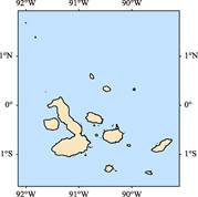
Figure 1 Coastline data map of the Archipiélago de Colón
|
The Archipielago de Colon (Galapagos Islands) is located in the Pacific Ocean and at about 1,000 km west of the Ecuador continent. The geo-location is 1.25′45″S-1.41′36″N, 91.40′9″W-89.29′43″W (Figure 1). The islands are consisted of a series of volcanos, 186 islands and giant rocks in total, each of them is larger than 40 m2 in area. There are 7 islands which are larger than 100 km2; 18 islands which are larger than 1 km2. The total area of the islands is 8,010.19 km2, and the coast line is 1,819.92 km. The biggest one is the Isabela Island with area of 4,716.62 km2[1].
The Archipielago de Colon is a province of Ecuador[2]; the capital of the province is Puerto Baquerizo Moreno. Three cantons are included in the province[3]. They are Isabela Canton, San Cristobal Canton and Santa Cruz Canton. The Darwin (Culpepper) Island, Fernandina (Narborough) Island, Isabela (Albemarle) Island and Wolf (Wenman) Island are located in the Isabela Canton. The Espanola (Hood) Island, Floreana (Charles or Santa Marla) Island, Genovesa Island, San Cristobal Island and Barrington Island are located at the San Cristobal Canton. The Baltra Island, Bartholomew Island, Marchena Island, North Seymour Island, Pinta Island, Pinzon Island, Jervis Island, Santa Cruz Island, Santiago James Island are located at the Santa Cruz Canton. The Archipielago de Colon is managed as the National Part of Ecuador and on the UNESCO Heritages List in 1978. The main islands of the Cologne Islands are shown in Table 1.
Table 1 Main islands of the Cologne Islands
|
Name of islands
|
Geo-location
|
Area (km2)
|
Coastline (km)
|
|
Watson Island
|
1º20′49″S-1º20′46″S, 90º18′35″W-90º18′26″W
|
0.019
|
0.734
|
|
Espanola Island
|
1º24′42″S-1º20′40″S, 89º44′46″W-89º37′5″W
|
60.742
|
49.116
|
|
Islote Gardner
|
1º20′52″N-1º20′20″N, 89º38′57″W-89º38′20″W
|
0.594
|
4.177
|
|
Isla Gardner
|
1º20′19″S-1º19′43″S, 90º18′2″W-90º17′24″W
|
0.772
|
4.574
|
|
Isla Caldwell
|
1º18′46″S-1º18′16″S, 90º20′28″W-90º20′3″W
|
0.225
|
3.014
|
|
Santa Maria Island
|
1º21′37″S-1º13′13″S, 90º30′41″W-90º21′8″W
|
172.945
|
70.893
|
|
Tortuga Island
|
1º1′26″S-1º0′26″S, 90º53′6″W-90º51′42″W
|
1.272
|
10.039
|
|
Islote Las Tintoreras
|
0º58′37″S-0º58′3″S, 90º57′45″W-90º57′33″W
|
0.190
|
4.034
|
|
Santa Fe Island
|
0º50′23″S-0º47′55″S, 90º5′29″W-90º1′38″W
|
24.704
|
24.678
|
|
San Cristóbal Island
|
0º57′22″S-0º41′6″S, 89º37′42″W-89º14′27″W
|
558.713
|
184.875
|
|
Pinzón Island
|
0º38′5″S-0º35′15″S, 90º41′18″W-90º38′33″W
|
17.877
|
17.991
|
|
Santa Cruz Island
|
0º46′31″S-0º28′54″S, 90º33′1″W-90º10′8″W
|
986.544
|
212.917
|
|
Isla Daphne Mayor
|
0º25′33″S-0º25′8″S, 90º22′29″W-90º22′10″W
|
0.337
|
2.199
|
|
Baltra Island
|
0º29′3″S-0º24′39″S, 90º17′57″W-90º14′51″W
|
25.738
|
28.079
|
|
Rábida Island
|
0º25′40″S-0º23′51″S, 90º43′14″W-90º41′48″W
|
5.027
|
11.225
|
|
Isla Daphne Minor
|
0º23′47″S-0º23′37″S, 90º21′10″W-90º21′1″W
|
0.059
|
0.923
|
|
North Seymour Island
|
0º24′3″S-0º23′19″S, 90º17′37″W-90º16′33″W
|
1.904
|
5.985
|
|
Bartolomé Island
|
0º17′27″S-0º16′47″S, 90º33′36″W-90º32′26″W
|
1.320
|
7.123
|
|
Fernandina Island
|
0º30′24″S-0º15′36″S, 91º39′43″W-91º22′37″W
|
645.487
|
123.686
|
|
Santiago (San Salvador, James) Island
|
0º22′31″S-0º8′43″S, 90º52′19″W-90º32′47″W
|
577.391
|
155.646
|
|
Isabela Island
|
1º3′11″S-0º10′4″N, 91º35′39″W-90º46′50″W
|
4,716.622
|
682.009
|
|
Genovesa Island
|
0º17′59″N-0º20′48″N, 89º58′41″W-89º56′9″W
|
13.907
|
23.065
|
|
Marchena Island
|
0º16′37″N-0º23′16″N, 90º32′35″W-90º24′2″W
|
131.499
|
54.378
|
|
Pinta Island
|
0º32′23″N-0º38′37″N, 90º47′26″W-90º43′6″W
|
59.934
|
39.149
|
|
Wolf Island
|
1º22′26″N-1º23′42″N, 91º49′33″W-91º48′41″W
|
1.286
|
8.567
|
|
Darwin Island
|
1º40′28″N-1º40′54″N, 92º0′32″W-91º59′54″W
|
0.651
|
3.880
|
The dataset is developed based on Google earth images, and archived in the .kmz and shp data formats with the compressed data size of 11.8 MB.
References
[1] Liu, C., Shi, R. X., Zha, F. L. Coastline of the Archipiélago de Colón (Galapagos Islands) [DB/OL]. Global Change Research Data Publishing & Repository, 2016. DOI: 10.3974/geodb.2016.05.11.V1.
[2] Wikipedia. Galápagos Islands [Z]. https://en.wikipedia.org/wiki/Gal%C3%A1pagos_Islands.
[3] Galápagos Islands. The World Book Encyclopedia (Volume 8) [M]. Field Enterprises Educational Cooperation, USA, 1976: 7-8.