Earth Data Encyclopedia
Yalu River and Basin
Liu, C.1* Shi, R. X.1 Hao, M. M.1,2
1. Institute of Geographic Sciences and Natural Resources Research, Chinese Academy of Sciences, Beijing 100101, China;
2. University of Chinese Academy of Sciences, Beijing 100049, China
Keywords: Yalu River; Basin; China; North Korea; data encyclopedia
The Yalu drainage basin locates between the Tumen River Basin, Songhua River Basin in north and the West Korea Bay in south; the Liao River Basin in west and the Taedong-gang River basin in east, its geolocation is from 39°43′57″N to 42°17′28″N, 123°35′59″E to 128°45′50″E. It covers an area of 65,215.49 km²??in which, 32,799.22 km² is in China and 32,416.27 km² in North Korea. The boundary of the Yalu basin in China part is from the southern slope of Changbai Mountain to Changbai Mountain range in southwest, and to the northern part of Qian Mountain Range, and then go to south to the West Korea Bay; in North Korea part, the boundary from the Changbai Moutain to Motianling Mountain in the southeast, then turn to southwest in Mt. Touliu (23.9 m) to Pujon Mt. range, and then turn to west from Yongung-Ri to Mt. Lunglin (2,148 m), Kwangsong, Songwon, again, turn to southwest to Mt. Diyuling, Mt. Jiangnan to West Korea Bay. The Yalu River rises in southern slope of Tianchi Lake of Mt. Changbai and meets the Yellow Sea at the West Korea Bay, it is 844.98 km long. Its tributaries include Hochon, Changjin, Houzhou, Cicheng, Tongro, Zhongman, and Sanqiao Rivers in P. R. Korea; Hun, Pushi, and Ai Rivers in China. It covers areas of Chang Bai Man Aoton County, Linjiang City, Jian City, Huairen Man County, Kuandian Man County, Dandong City and Donggang City in China and Ryanggang, Chagang and North Pyongan Provinces in North Korea. Because of the temperature monsoon weather (the annual rain fall is 800-1,200 mm) and the steep slope of mountain land, the high gradient reaches 3.2‰, and even 10‰ in some region. More reservoirs were constructed along the river, they are: Shuifeng R. (China and North Korea), Yunfeng R. (China and North Korea), Wiwon R. (China and North Korea), Tiejia R. (China), Huanren R. (China), Huilongshan R. (China), Manfeng-Ho (North Korea), Songwon R. (North Korea), Sijung-Ho (North Korea), Rangrim-Ho (North Korea), Changjin-Ho (North Korea), Fuzhan-Ho (North Korea), Phungso-Ho (North Korea) and Hochon River R. (North Korea). The dataset including the Yalu River and its basin in .kmz and .shp data formats, the data size is 43.8 MB (20.1 MB in compressed).
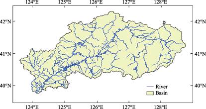
Figure 1 Map of Yalu River and Basin
Table 1 Statistics of lakes (reservoirs) in Yalu river basin (2016±1)
|
Name of Lake (Reservoir)
|
Country
|
Area (km2)
|
Name of Lake
(Reservoir)
|
Country
|
Area (km2)
|
|
Shuifeng R.
|
China, North Korea
|
216.32
|
Hochon River R.
|
North Korea
|
31.61
|
|
Yunfeng R.
|
China, North Korea
|
65.27
|
Songwon R.
|
North Korea
|
28.01
|
|
Wiwon R.
|
China, North Korea
|
30.75
|
Sijung-Ho
|
North Korea
|
25.33
|
|
Huanren R.
|
China
|
87.55
|
Rangrim-Ho
|
North Korea
|
23.42
|
|
Huilongshan R.
|
China
|
18.20
|
Fuzhan-Ho
|
North Korea
|
12.91
|
|
Tiejia R.
|
China
|
15.29
|
Phungso-Ho
|
North Korea
|
12.12
|
|
Changjin-Ho
|
North Korea
|
36.34
|
Manfeng-Ho
|
North Korea
|
10.22
|
Table 2 Statistics of Yalu River and its branches
|
Yalu River
|
Branches of Yalu River
|
|
Countries
|
Length (km)
|
Branch
|
Country
|
Length (km)
|
Branch
|
Country
|
Length (km)
|
|
China, North Korea
|
844.98
|
Hun River
|
China
|
416.34
|
Houzhou River
|
North Korea
|
62.43
|
|
|
|
Pushi River
|
China
|
139.84
|
Cicheng River
|
North Korea
|
105.05
|
|
|
|
Ai River
|
China
|
206.04
|
Tongro River
|
North Korea
|
238.81
|
|
|
|
Hochon River
|
North Korea
|
343.73
|
Zhongman River
|
North Korea
|
141.18
|
|
|
|
Changjin River
|
North Korea
|
245.23
|
Sanqiao River
|
North Korea
|
125.01
|