Settlement Places Change Dataset during the Last 300y in Zhangjiuhe Basin, Yunnan Province, China
Huo, R. L.1 Yang, Y. D.2* Man, Z. M.
1. Collaborative Innovation Center for Security and Development of Western Frontier China, Sichuan
Univerisity, Chengdu 610065, China;
2. Center for Historical Geographical Studies of Fudan University, Shanghai 200433, China
Abstract: Zhangjiuhe or Zhangjiu River is one of the branches of Yangtze River located in Yunnan province of China. The 767 settlement places during the last 300 year in Zhangjiuhe basin were geo-located based on the comprehensive utilization of toponymical records, historical documentaries and field investigation data. The data product indicated that, the settlements changes in Zhangjiuhe basin in the past 300 years can be segmented into three stages namely slow growth period (1700 to 1800), fast growth stage (1800 to 1950) and another slow growth stage (1950 to 2000). Spatial study indicated that the valleys at middle and lower reaches of the river have the greatest density of settlements, expanded from the middle and lower reaches to middle and upper reaches, and vice versa, as well as from the valley areas to the remote mountainous areas at both sides. As for the primary factors affecting evolution of settlements in the basin, the boundary of natural environmental condition might be broken through frequently, but the areas at the height of 2,200 m and 2,500 m and with the slope of 20 degree are the important limits for the expansion of settlements.
Keywords: settlements; ethnic minorities; 300 Years; temporal and spatial evolution; Zhangjiuhe basin; Yunnan
1 Introduction
A settlement is a general term applied to the places where humans live and as such can include buildings, structures, roads, greenbelts, water sources, and other material elements[1]. In general, settlements are classified into rural and urban examples; those discussed in this paper are all rural. Patterns in the distribution and evolution of settlements are affected by both natural environmental and socioeconomic factors[2]. Previous researchers have explored the relationships between contemporary settlement distribution patterns and related natural and human factors[3–7]; since these relationships are the result of historical development, studies that address the evolution of these patterns throughout different time periods can shed light on land development processes in human-land relationships[8–9]. Such approaches have generated a rich body of publications[9–12].
Mountainous regions are characterized by different altitudes and gradients [13], and the ethnic and cultural communities that live in these areas are often quite distinct from their counterparts on the plains[14]. This difference also means that the spatial distribution and evolution of settlements in mountainous regions is markedly distinct from that on the plains, as are changes in land cover. It is therefore valuable to investigate the evolution of settlement distributions in mountainous regions, and to understand the dominant mechanisms that underlie these patterns. Existing research in this area has mainly utilized data obtained from remote sensing images, land use surveys, and other fieldwork, in combination with GIS spatial studies; investigations have spawned a range of qualitative and quantitative analyses that have addressed the landforms, ethnic and cultural identities, demographic profiles, and socioeconomic patterns that characterize present-day mountain settlements[14–19]. Previous research at the century-scale or over several centuries, however, has been limited to qualitative approaches alone[20], because of the lack of statistical data.
2 Metadata of Dataset
The metadata of pattern evolution of settlement space in the Zhangjiuhe basin, Yunnan province, during the past 300 years dataset is summarized in Table 1. It includes the dataset full name, short name, authors, year of the dataset, temporal resolution, spatial resolution, data format, data size, data files, data publisher, and data sharing policy, etc[22–23].
3 Methods
The sources used to compile this database mainly included the New County Gazetteer, historical documents, materials from field investigations, and digital elevation model (DEM) outputs.
The Zhangjiu River basin is located in Luquan Autonomous County of the Yi Nationality and the Miao Nationality, Yunnan province, 25°25′??-26°26′??, 102°14′E-102°56′E.
3.1 Data Collection and Processing
3.1.1 The New County Gazetteer
The basic data on settlements within the Zhangjiu River basin used in this study was extracted from the Place Name Gazetteer of Luquan Autonomous County of the Yi and Miao Nationality, Yunnan Province (1995)[25]. This gazetteer contains records of 3,193 place names, of which 784 are settlements within the Zhangjiu River basin; this publication also records the meanings of names, administrative divisions, population data including nationality composition, and the area of arable land included within each settlement up until the end of 1990, alongside detailed information on their establishment in some cases. Since only less than ten percent of the total settlements records provided information about the dates of establishment, supplementary historical sources were required to reconstruct patterns over the last 300 years.
3.1.2 Historical Documents
In addition to the New County Gazetteer, historical documents related to Luquan county were also consulted as part of this study, including the Luquan District Chorography from the Kangxi Period (1719)[26] , Miscellaneous Records on Luquan compiled by a former magistrate of this region that was printed in 1780 [27], and Luquan district Chorography from the Republic Era[28]. Although all these materials provide settlement information encompassing long periods of time, they are incomplete and relatively simple since they only contain the names and positions of sites within the overall administrative structure of the Qing Dynasty.
Table 1 Metadata summary of Database of pattern evolution of settlement space in Zhangjiuhe Basin, Yunnan Province, during the past 300 years
|
Items
|
Description
|
|
Dataset full name
|
Settlement dataset in Zhangjiuhe basin, Yunnan province, during the past 300 years [21]
|
|
Dataset short name
|
P_ZhangjiuRBasin
|
|
Authors
|
Huo, R. L. P-9632-2017, Collaborative Innovation Center for Security and Development of Western Frontier China, Sichuan University, Chengdu 610065, China, huorenlong@hotmail.com
Yang, Y. D. U-1697-2017, Center for Historical Geographical Studies of Fudan University, Shanghai 200433, China, ydyang@fudan.edu.cn
Man, Z. M. U-7242-2017, Center for Historical Geographical Studies of Fudan University, Shanghai 200433, China, manzhimin@fudan.edu.cn
|
|
Geographical region
|
Zhangjiuhe River Basin, Luquan County, Yunnan Province??
25°25′N-26°26′N, 102°14′E-102°56′E
|
|
Year
|
1700-2000
|
|
Temporal resolution
|
50 years
|
|
Data format
|
.kmz, .shp, .jpg
|
|
|
|
Data size
|
13.4 MB
|
|
|
|
Data files
|
Geo-location of Zhangjiu River basin, coded message, years, settlement name, village name, Elevation, topographic slope, etc.
|
|
Foundation(s)
|
Ministry of Education of P. R. China (13YJA770041, 201114)
|
|
Data publisher
|
Global Change Research Data Publishing & Repository, http://www.geodoi.ac.cn
|
|
Address
|
No. 11A, Datun Road, Chaoyang District, Beijing 100101, China
|
|
Data sharing policy
|
Data from the Global Change Research Data Publishing & Repository includes metadata, datasets (data products), and publications (in this case, in the Journal of Global Change Data & Discovery). Data sharing policy includes: (1) Data are openly available and can be free downloaded via the Internet; (2) End users are encouraged to use Data subject to citation; (3) Users, who are by definition also value-added service providers, are welcome to redistribute Data subject to written permission from the GCdataPR Editorial Office and the issuance of a Data redistribution license; and (4) If Data are used to compile new datasets, the ‘ten percent principal’ should be followed such that Data records utilized should not surpass 10% of the new dataset contents, while sources should be clearly noted in suitable places in the new dataset [24].
|
3.1.3 Information from Field Investigations
Field-based information was obtained within the Zhangjiu River Basin over a total of 44 working days between April 2nd, 2015, and May 16th, 2015. Fieldwork in this case mainly comprised a series of oral interviews conducted within the administrative villages that made up the main investigative units within the basin. Interviewees were mainly knowledgeable locals familiar with the various natural settlements within these villages, while the content of the interviews included questions about the names of the first families to settle in an area (i.e. the families who had founded each natural village and the number of generations who had lived at these locations; whether, or not, these families had a recorded lineage; and the sequence of natural village establishment within administrative areas). A second investigation was then carried out if the results from the first round of interviews proved inadequate; in this case, the establishment date for each natural village was calculated on the basis of both interview information and historical family records.
A sufficient level of information for 767 settlements was obtained via fieldwork, encompassing 98 percent of the total (784 settlements); the remaining 17 were not surveyed because they were located in remote mountainous areas. The establishment dates for all of the settlements included in this study were confirmed using population data including nationality composition and the conditions of their adjacent counterparts using the historical sources discussed previously.
3.1.4 DEM
The software ArcGIS10.0 was utilized in this study to generate depression infills for the DEM dataset[29], while the Arc Hydro Tools was used to produce a topographic map of the Zhangjiu River basin and generate an overall gradient grid map.
3.2 Database Development
Foundation dates for settlements were calculated by assimilating information from the New County Gazetteer and historical documents with those gathered during fieldwork. These were then entered into the “settlement date” field, and historical place names within the basin were marked on the digital topographic map using the “Administrative Map of Luquan Autonomous County of the Yi Nationality and the Miao Nationality, Yunnan province” (2005). This map has a scale of 1??125,000 and was utilized in tandem with older charts from the Republican Era and administrative maps of Luquan county that were compiled at the beginning of the 1950s (obtained from the Archives of Luquan county). Information was then added to connect the overall database to ArcGIS, as well as every settlement to an attribute list. Elevations and gradient information were then extracted automatically from the digital topographic map of each settlement and stored in related attribute fields. Maps were constructed on the basis of these data to reveal the spatio-temporal processes of settlement evolution within the Zhangjiuhe basin at a 50-year moving average over the last 300 years and were used for further analyses (Figure 1).
In order to analyze spatial trends in settlement evolution within the Zhangjiu River basin, the software ArcGIS was employed to perform mean center and standard deviation ellipse analyses of sites established before 1700 as well as for those that were newly established within each 50-year period over the last 300 years. In this context, mean center denotes the geographic center (or density center) of a data series, while a standard deviation ellipse (also called a directional distribution) summarizes the spatial features of geographic elements, such as the central trend, discrete and direction trends – an effective way to analyze geographic data with directivity.
4 Results and Validation
4.1 Data Products
The consistent and description of the dataset is shown in Table 2. The temporal distribution of settlements within the Zhangjiuhe River basin at 50-year intervals over the last 300 years is shown in Figure 2.
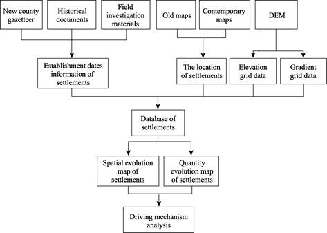
Figure 1 Flowchart of the dataset development
Table 2 Data files of the pattern evolution of settlement space in the Zhangjiuhe basin, Yunnan province, during the past 300 years
|
Name
|
Description
|
|
Data entity
|
Dataset of 784 settlements in Zhangjiuhe basin
|
|
Figure
|
Figure of pattern evolution of settlements space in the Zhangjiuhe basin in every 50-year period
|
|
File
|
Description of data collection, process, products, and conclusion, etc.
|
|
Sample
|
Data Sample
|
4.2 Data Analysis
The evolutionary patterns revealed by this analysis show that the mean center and standard deviation ellipse of newly established settlements within the Zhangjiu River basin at 50 year stages over the last 300 years can be summarized can be summarized as follows.Village settlements were mainly distributed prior to 1700 in the lower and middle reaches of the Zhangjiu river as well as on the plains areas of the upper stream, whereas new settlements that were established subsequently expanded into the middle and upper reaches as well, and especially into high-altitude mountainous areas on either side of the valley.
The data presented here shows that the evolution of settlement distribution patterns within the Zhangjiu River basin over the past 300 years initially expanded longitudinally from the middle and lower reaches into the middle and upper reaches of the river, before switching back from the middle and upper reaches to the middle and lower reaches. In terms of width, the distribution of settlements within the basin has also tended to expand out from the valley area into more remote mountainous areas. The evolution of settlement distribution patterns in this region also reflects processes of population migration and land development within the more mountainous regions of the Zhangjiu River basin.
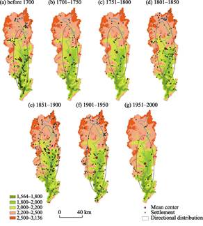
Figure 2 Mean center and standard deviation ellipse of newly added settlements distribution
in the Zhangjiuhe basin
As mentioned earlier, the comprehensive dataset presented here utilizes information extracted from the New County Gazetteer, as well as from historical documents, maps, field investigations, and DEM data. As such, this dataset is therefore more reliable than alternative compilations based on single sources of data. The reconstruction approach utilized here employed 50-year intervals to reconstruct patterns in the evolution of settlement space and as a result a substantial improvement in time resolution over the last 300 years has been achieved.
5 Discussion
Because of less information about the settlement before 1900, so, the data related to the settlement before 1900 is less reliable than that after 1900.
Author Contributions
Man, Z. M., Yang, Y. D., and Huo, R. L. designed the algorithms of dataset. Huo, R. L. contributed to the data processing and analysis. Huo, R. L. and Yang, Y. D. wrote the data paper.
References
[1] Chen, G. J., Fang, Y. P., Chen, Y., et al. Development and Report in Mountain Area of China [M]. Beijing: The Commercial Press, 2007.
[2] Jin, Q. M. The Rural Settlement Geography [M]. Nanjing: Jiangsu Science and Technology Press, 1989.
[3] Tang, G. A., Zhao, M. D. A GIS based research on the distribution of rural settlements: Taking Yulin area as an example [J]. Economic Geography, 2000, 20(5): 1-4.
[4] Li, Q. L., Ma, X. D., Shen, Y. Analysis of spatial pattern of rural settlements in northern Jiangsu [J]. Geographical Research, 2012, 31(1): 144-154.
[5] Guo, X. D., Ma, L. B., Zhang, Q. Y. A GIS-based research on the spatial evolution characteristics and driving mechanism of the rural settlements in Qin’an county [J]. Economic Geography, 2012, 32(7): 56-62.
[6] Hai, B. B., Li, X. J., Xu, J. W. Spatio-temporal evolution of rural settlements in Gongyi [J]. Geographical Research, 2013, 32(12): 2257-2269.
[7] Sun, Y., Cheng, Y. Q., Zhang, P. Y. Spatio-temporal dynamics of rurality in Northeast China [J]. Geographical Research, 2015, 34(10): 1864-1874.
[8] Han, M. L., Zhang, W. W. Spatial and temporal variation of settlements of Bairin Left Banner in Xiliao River Valley in the first half of 20th century [J]. Scientia Geographica Sinica, 2009, 29(1): 71-77.
[9] Zeng, Z. Z, Fang, X. Q., Ye, Y. The pattern evolution of settlements in Jilin province over the past 300 years [J]. Scientia Geographica Sinica, 2011, 31(1): 87-94.
[10] Fang, X. Q., Ye, Y, Ge, Q. S., et al. Land exploitation in the Northeast China during the Qing Dynasty inferred from the development of town system [J]. Scientia Geographica Sinica, 2005, 25(2): 129-134.
[11] Han, M. L., Zhang, Y., Fang, C., et al. Location and environment of the settlements and man-land relationship in West Liaohe River Basin since Holocene [J]. Geographical Research, 2008, 27(5): 1118-1128.
[12] Zeng, Z. Z., Fang, X. Q., Ye, Y. The process of land cultivation based on settlement names in Jilin province in the past 300 years [J]. Acta Geographica Sinica, 2011, 66(7): 985-993.
[13] Wang, C. S., Sun, G. Y, Zhu, S. S. The major research progress on spatial evolution of rural settlements in mountainous areas of western China [J]. Human Geography, 2011, 26(5): 9-14.
[14] Luo, G. J., Li, Y. B., Wang, S. J. Analysis of settlements distribution pattern and changes in karst mountainous areas: Taking the Houzhai Watershed region in Puding county as an example [J]. Resources and Environment in the Yangtze Basin, 2010, 19(7): 802-807.
[15] Shi, M. Q., Wang, Q, Guo, Y. L., et al. Analysis on spatial distribution characteristics in the upper reaches of Min River [J]. Journal of Southwest University of Science and Technology, 2014, 29(4): 33-37.
[16] Wang, Q., Shi, M. Q., Guo, Y. L., et al. The vertical differentiation of the mountain settlement niche in the upper reaches of Minjiang River [J]. Acta Geographica Sinica, 2013, 68(11): 1559-1567.
[17] Wang, C. S., Sun, G. Y., Sun, W., et al. Spatial characteristics and formation mechanism of slope settlements in Zhaotong of Yunnan province [J]. Journal of Natural Resources, 2011, 26(2): 237-246.
[18] Luo, G. J., Li, Y. B., Tan Q., et al. Analysis of changes in settlement patterns and its LUCC response in Karst mountainous areas: A case on Guizhou province [J]. Resources Science, 2010, 32(11): 2130-2137.
[19] Li, S. K., Zhang, Y., Yan, X., et al. Using GIS techniques to assess spatial pattern of rural settlements in Qinba Mountainous region: a case study in Zhuxi county, Hubei province [J]. Research of Agricultural Modernization, 2014, 35(6): 780-785.
[20] Lan, Y. Development of the distribution of towns in Southwest China in Ming and Qing dynasties [J]. Journal of Chinese Historical Geography, 1995(1): 107-118.
[21] Zhong, X. H. Mountain Introduction and Mountain Research of China [M]. Chengdu: Sichuan Science and Technology Press, 2000.
[22] Huo, R. L., Yang, Y. D., Man, Z. M. Pattern evolution of settlement space in the Zhangjiuhe basin, Yunnan province, during the past 300 years [J]. Geographical Research, 2016, 35(9): 1647-1658.
[23] Huo, R. L., Yang, Y. D., Man, Z. M. Settlement dataset in Zhangjiuhe basin, Yunnan province, during the past 300 years [DB/OL]. Global Change Research Data Publishing & Repository, 2017. DOI: 10.3974/geodb.2017.03.13.V1.
[24] GCdataPR Editorial Office. GCdataPR Data Sharing Policy [OL]. DOI: 10.3974/dp.policy.2014.05 (Updated 2017).
[25] Chorography Compilation Committee of Luquan. History of Luquan County [M]. Kunming: Yunnan People’s Publishing House, 1995.
[26] Li, T. Z. Gazetteer of Luquan District [O]. 1719.
[27] Tan, C. Miscellaneous records on Luguan county (Nongbu Suolu [O]). 1780.
[28] Xu, S. Gazetteer of Luquan County [O]. Taipei: Cheng Wen Publishing Co., reprinted, 1975.
[29] Computer Network Information Center, Chinese Academy of Sciences. (http://www.gscloud.cn).