Global Change Data Encyclopedia
Sicily Island
Shi, R. X. Liu, C.*
Institute
of Geographic Sciences and Natural Resources Research, Chinese Academy of
Sciences, Beijing 100101, China
Keywords: Sicily Island; the Mediterranean Sea; Italy; 2015; data
encyclopedia
Dataset Availability
Statement:
The dataset supporting this paper was published and
is accessible through the Digital Journal of Global
Change Data Repository at: https://doi.org/10.3974/geodb.2020.04.16.V1.
Sicily
Island[1] is the biggest island in the Mediterranean Sea. It is
located between the Apennine Peninsula and North Africa[2-3], and
is separated 3.12 km from the Apennine Peninsula by the Messina Strait in its
northeast, separated 144 km from the North Africa in its southwest, and 81 km
from the Gozo Island in its south. There are also some small islands around the
Sicily Island, such as Pantelleria Island, Ustica Island, Lipari Islands,
Egadian Islands and Pelagie Islands[2-3]. The Sicily Island belongs to Sicily region of Italy. Palermo, the
port city on the northwest coast of the island, is the capital of Sicily.
|
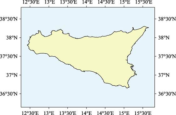
Figure
1 Map
of the Sicily Island (.shp format)
|
Geo-location of
the Sicily Island is between 36??38??48??N and 38??18?? 5??N, 12??25??27??E and
15??39??11??E[4] (Figure 1-2). The Sicily Island is like an isosceles trapezoid with the short
base on the west side and the longer base on the east side. The island is full
of mountains and hills, and earthquakes are frequent. The climate of the Sicily
Island is characterized by subtropical and Mediterranean climates, with warm
and humid winter and dry and hot summer. There are rich in citrus, lemon and olives.
|
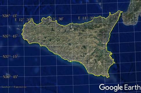
Figure 2
Map of the Sicily Island
(.kmz format)
|
The Sicily Island is a famous tourist
destination. The archaeological area of Agrigento (also known as the ??Valley of
the Temple??) on the southwest coast of the island was included in the ??World
Heritage List?? in 1997.
In the northeastern
of the Sicily Island, there is Mount Etna, which is the largest and most active
volcano in Europe. This volcano was included in the ??World Heritage List?? by
UNESCO in 2013. Arab-Norman style buildings and the Cathedrals of Cefalu and
Monreale in Palermo were included in the ??World Heritage List?? in 2015.
The area of the
Sicily Island is 25,439.42 km² in Albers projection, and the coastline is
1,460.19 km in Lambert projection. The dataset was developed based on the
global multiple scale shorelines dataset based on Google Earth images (2015)[5-6], and maps of Italy[2-3]. The dataset is consisted of 17
data files and archived in .kmz and .shp data formats with the data size of
6.21 MB (Compressed to 4.22 MB in two data files).
References
[1] Editorial Team of Handbook of Global Geographical Names. Handbook of
Global Geographical Names [M]. Beijing: SinoMaps Press; Surveying and Mapping
Press, 1999.
[2] Fan, Y. Atlas of Europe [M]. Beijing: SinoMaps Press, 2000.
[3] SinoMaps Press. Atlas of Italy [M]. Beijing: SinoMaps Press, 2008.
[4] Shi, R. X., Liu, C. Sicily Island [J/DB/OL]. Digital Journal of Global Change Data Repository, 2020. https://doi.org/10.3974/geodb.2020.04.16.V1.
[5] Liu, C., Shi, R. X., Zhang, Y. H., et al. Global multiple scale shorelines dataset based on Google
Earth images (2015) [J/DB/OL]. Digital
Journal of Global Change Data Repository, 2019. https://doi.org/ 10.3974/geodb.2019.04.13.V1.
[6] Liu, C., Shi, R. X., Zhang, Y. H., et al. 2015: How many islands (isles, rocks), how large land areas,
and how long of shorelines in the world? ??Vector data based on Google Earth
images [J]. Journal of Global Change Data
& Discovery, 2019, 3(2): 124?C148.
https://doi.org/10.3974/geodp.2019.02.03.