Analysis to the Highest Impact Dataset 2018 from the Geographical Society of China
Liu, C.1* Liao, X. H.1 Zhang, G. Y.2 Shi, R. X.1 Chen, L. J.3 Ma, J. H.1
Zhu, Y. Q.1
1. Institute of Geographic Sciences and Natural Resources Research, Chinese Academy of Sciences, Beijing 100101, China;
2. Geographical Society of China, Beijing 100101, China;
3. National Geomatics Center of China, Beijing 100830, China
Abstract: On August 28, 2018, the Geographical Society of China (GSC) established a Big Geographic Data Working Committee (GSC_BigData) and released the Dataset Impact Ranking 2018 of the Geographical Society of China based on methodology of Data Impact Score(DIS) and the statistics of dataset citations and the related journal impact factor. The “Datasets of the boundary and area of the Tibetan Plateau” (Zhang, Y. L., Li, B. Y., and Zheng, D.), which was published in June 2014, was ranked the first place with the total DIS of 67.844,3 in the last five years. The authors analyzed the reasons why this dataset can rank first from the perspectives of data content, data authors, funding, data policy, data publication, data dissemination, and data citation. From 1987, when the paper “On the extent of the Qinghai-Xizang (Tibet) Plateau” was published by Prof. Li, to 2014, when the “Datasets of the boundary and area of the Tibetan Plateau” was finally published, the authors experienced 27 years of research in that area. With the development of big geographic data, the demand of data users for spatial resolution has been increasingly higher. The updated demand of the authors of “Datasets of the boundary and area of the Tibetan Plateau” from 1??1,000,000 to higher spatial resolution and even the meter-level resolution has given a new mission to the dataset. From data browsing, data downloading, and data citation, we find that the current citation is not standardized for the users of the data. Many unstandardized phenomena, such as “using the data without citation” or “citing the data but not standardized”, need to be improved. The case of “Datasets of the boundary and area of the Tibetan Plateau” shows that data reuse is the most important way to continue mining the data value and developing their scientific value. DIS is helpful to measure the dynamic change of data reusing and to promote the development of the data value, which will facilitate the protection of intellectual property rights of scientific data, promote the efficiency of scientific research, and provide savings in the national public scientific research funds.
Keywords: Data Impact Score (DIS); 2018 rankings; Geographical Society of China; Qinghai-Tibet Plateau
1 Introduction
On August 28, 2018, the Geographical Society of China (GSC) established the Big Geographic Data Working Committee of the Geographical Society of China (BigData_GSC)[1] and released the Dataset Impact Ranking 2018 of the Geographical Society of China based on methodology of the Data Impact Score (DIS), the statistics of dataset citations and the related journal impact factor[2]. The “Datasets of the boundary and area of the Tibetan Plateau” (Zhang, Y. L., Li, B. Y., and Zheng, D.)[3–4] , which was published in June 2014, ranked in first place with the total DIS of 67.844,3 during the last five years[2] (Figure 1). Dr. Fu, J. Y., Associate Prof. of the Institute of Geographic Science and Natural Resources Research, Chinese Academy of Sciences (IGSNRR/CAS), as the dataset author, was ranked at the top of the dataset authors’ ranking list in 2018, because she published two more datasets with a high impact factor. One was “1 km grid population dataset of China”[5–6], as the first author of the dataset, and the other was “1 km grid of GDP data of China (2005, 2010)”[7–8], where she was the third author of the dataset. She got the Highest Impact Data Author award 2018 of Geographical Society of China. Her DIS was 39.460,0[2] in the last five years (2014-2018).
Table 1 Datasets DIS (Data Impact Score) Ranking 2018 of Geographical Society of China (Top 8)[2]
|
Title of dataset
|
First author
|
Year
published
|
DIS
|
Ranking
|
|
Datasets of the boundary and area of the Tibetan Plateau
|
Zhang, Y. L.
|
2014
|
67.844,3
|
1
|
|
1 km grid population dataset of China
|
Fu, J. Y.
|
2014
|
63.132,1
|
2
|
|
1 km grid GDP data of China (2005, 2010)
|
Huang, Y. H.
|
2014
|
31.575,8
|
3
|
|
1 km/5 day surface reflectance product over China and the Association of Southeast Asian Nations for 2013
|
Zhong, B.
|
2015
|
6.657,0
|
4
|
|
Cropping rotation system data of China
|
Xu, X. L.
|
2014
|
6.514,5
|
5
|
|
Time series of land ecosystem classification dataset of China in five-year increments
|
Xu, X. L.
|
2015
|
5.400,0
|
6
|
|
Global artificial land surface dataset at 30 m resolution (2010)
|
Chen, J.
|
2014
|
3.122,0
|
7
|
|
Remotely sensed dataset of grassland degradation on the Qinghai-Tibetan Plateau
|
Wang, J.
|
2014
|
2.822,4
|
8
|
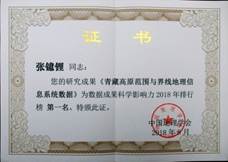
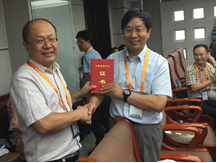
Figure 1 Prof. Liao X. H., Chair of the GSC_BigData awarded the certificate of Top 1 in the Datasets Impact Ranking to Zhang, Y. L.
2 Introduction to the Datasets of the Boundary and Area of the Tibetan Plateau
2.1 Datasets of the Boundary and Area of the Tibetan Plateau
The “Datasets of the boundary and area of the Tibetan Plateau” was published in Global Change Research Data Publishing & Repository (GCdataPR) in June 2014[3], and the data paper was published in Acta Geographica Sinica in 2014 (supplement)[4]. The dataset recorded the accurate location and quantitative conclusion of the range and boundary of Tibetan Plateau with the data format of ArcGIS .shp in 1??1,000,000 scale (Figure 2). Based on this dataset, the following conclusions can be drawn: the Qinghai-Tibet Plateau (Tibetan Plateau) is ranged from the southern edge of the Himalayan Range, adjacent to India, Nepal, and0020Bhutan; the northern edge of Kunlun, Altun, and Qilian Mountains, and joins the Tarim Basin and Hexi Corridor in the arid desert region of Central Asia with an elevation difference of about 4,000 m; the western edge of the Pamir Plateau and Karakorum Mountains, bordering on Kyrgyzstan, Tajikistan, Afghanistan, Pakistan, and Kashmir; the eastern edge of the south or east piedmont of Yulong Jokul, Daxueshan, Jiajin, Qionglai, and Minshan Mountains. The eastern and northeastern part of Qinghai-Tibet Plateau joins the west part of Qinling Mountain and the Loess Plateau. The geo-location of Qinghai-Tibet Plateau is 25°59′37″N-39°49′33″N, 73°29′56″E-104°40′20″E, covering an area of 2,542.30×103 km2 and a total boundary line of about 11,745.96 km. This dataset was updated in 2014 based on the resolution of 1??1,000,000 and published in .kmz and .shp formats. The dataset consists of 15 data files with a data size of 390 KB (compressed to 2 files, 289 KB)[3].
2.2 Dataset Authors
|
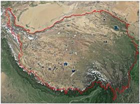
Figure 2 Geo-location of the Tibetan Plateau[3]
(.kmz format)
|
The “Datasets of the boundary and area of the Tibetan Plateau”[3] was developed by three authors, Prof. Zhang, Y. L., Prof. Li, B. Y., and Academician Zheng, D.
Zhang, Y. L. is the Professor of the IGSNRR/CAS, and Director of the Land Science and Biogeography Research Division; Professor of Excellence and Innovation Center in Earth Science of the Tibetan Plateau, Chinese Academy of Sciences (CAS); Prof. of the University of CAS; a lifetime honorary member of Nepal Geography Society; and National Outstanding Scientist of China. He is one of the academic leaders in the studies of the Qinghai-Tibet Plateau and the physical geography in China. He is recognized as a well-known scientist in Qinghai- Tibet Plateau studies[10–14].
Li, B. Y. is the Professor of the IGSNRR/CAS, and his focus in research is on geomorphology and the Quaternary environment of the Qinghai-Tibet Plateau. He participated in several scientific expeditions in the Qinghai-Tibet Plateau, collected a series of in situ and first-hand data and information, and achieved innovative results on the evolution of the paleogeographic environment of the Qinghai-Tibet Plateau[15], the boundary of the Qinghai-Tibet Plateau[3], the boundary of the Hengduan Mountains[16], and the geomorphological regionalization of China[17]. He published the paper “On the extent of the Qinghai-Xizang (Tibet) Plateau” in the journal of Acta Geographica Sinica in 1987, and pointed out that, based on the characteristics of the giant tectonic and geomorphological features of the Qinghai-Tibet Plateau, the contiguous plateau surface area with an altitude more than 4,000m belongs to the Qinghai-Tibet Plateau, and the sporadic areas, such as the plateau surface of the Hengduan Mountains, which are scattered but still can recover the boundary of the original plateau, and therefore should also be included in the Qinghai-Tibet Plateau[18].
Zheng, D. is an Academician of the Chinese Academy of Sciences, Prof. and Chairman of the academic degrees committee of IGSNRR/CAS, Prof. of the University of CAS, honorary Director of Tibetan Plateau Research Association of China, and Director of the Encyclopedia in Geography (China version). He put forward the principles and methods of natural regionalization suitable for mountains and plateaus[19]. In the study, he clarified the type system of vertical natural zones in plateau mountainous areas and constructed the distribution model[20–21]; he revealed the unique ecological phenomenon and spatial pattern of the plateau and the geographical differentiation of the flora of the plateau[22–23]; he clarified the three-dimensional zonal principles in the high-altitude region and put forward the natural regional system scheme of the Qinghai-Tibet Plateau[24]. As a leading researcher, his project “Comprehensive research on the uplift of the Tibetan Plateau and its impact on the natural environment and human activities” won the first prize of the National Natural Science Award in 1987[25].
From the time when Prof. Li, B. Y. published the paper “On the Qinghai-Xizang (Tibet) Plateau”[18] to the publication of the “Datasets of the boundary and area of the Tibetan Plateau” in 2014, the three authors have experienced 27 years of persistent exploration on the geographic information system data on the delineation of the Qinghai-Tibet Plateau and the multi-domain integration among the geomorphology, physical geography, plateau ecology, geographic information systems, and geographical data.
2.3 Founding Projects for the Datasets of the Boundary and Area of the Tibetan Plateau
The “Datasets of the boundary and area of the Tibetan Plateau” was developed under the following four funding projects: Ministry of Science and Technology of P. R. China (G1998040800), and the Chinese Academy of Sciences (CXIOGE01-01, CXIOG-A00-03-02, XDB03030500). Of course, the achievements under these four projects were more than this dataset.
3 Data Publishing, Data Sharing Policy, and Data Dissemination Pathway
3.1 Data Publishing
Data publishing includes the integrated publication of metadata, dataset, and data paper. All data need to be submitted in both Chinese and English in the website of GCdataPR. After peer review, metadata is associated with the DOI system, and the dataset is published in GCdataPR[3]. The data papers was published in Acta Geographica Sinica in 2014 (supplement)[4].
3.2 Data Sharing Policy
The dataset was published in GCdataPR in June 2014. The data sharing policy of the Journal ensures that each published dataset is openly available and can be freely downloaded via the internet (through the website of GCdataPR). Users are encouraged to use the dataset with a citation (a formal reference or proper location in the paper) The users, who are by definition also value-added service providers, are welcome to redistribute the dataset subject to written permission from the GCdataPR Editorial Office and the issuance of a data redistribution license. If the dataset is used to compile new datasets, the “ten percent principle” should be followed such that the data records utilized should not surpass 10% of the new dataset contents, while sources should be clearly noted in suitable places in the new dataset[26].
3.3 Data Dissemination Pathway
The “Datasets of the boundary and area of the Tibetan Plateau” can be disseminated in three ways: metadata dissemination, dataset dissemination, and data paper dissemination.
Metadata dissemination: After the “Datasets of the boundary and area of the Tibetan Plateau” was published, the metadata could be disseminated through the following pathways, besides the GCdataPR: the DOI registration system, the DCI (Data Citation Index) in the Web of Science (data citation index system in scientific website of Clarivate Analytics), and the data citation index system of the Global Earth Observation System of Systems (GEOSS) Portal and China GEOSS.
Dataset dissemination: All datasets are openly available to be accessed through the online GCdataPR at http://www.geodoi.ac.cn/WebEn/doi.aspx?Id=135.
Data paper dissemination: Official website of GCdataPR at http://www.geodoi.ac.cn, official website of Acta Geographica Sinica, and CNKI retrieval system.
Through the above data dissemination pathways and activities, the “Datasets of the boundary and area of the Tibetan Plateau” became the most used dataset among the datasets of the GCdataPR, with over 11,400 users worldwide from 74 countries.
4 Data Impact Score (DIS)
4.1 Statistics of Data Citation
This dataset has 11 citations since it was published (2014.06-2018.05, Table 2). In detail, it was self-cited once in 2014, and non-self-cited for 3, 1, 4, and 2 times in 2015, 2016, 2017, and 2018, respectively. The non-self citation ratio is 91%.
Table 2 Statistics of articles citing the “Datasets of the boundary and area of the Tibetan Plateau”
|
Article title citing the dataset
|
Title of journal citing the dataset
|
Citation year
|
Journal impact factor of the citation year*
|
Note
|
|
Datasets of the boundary and area of the Tibetan Plateau (data paper)[4]
|
Acta Geographica Sinica
|
2014
|
2.300,0
|
Self-citation
|
|
Characteristics and protection effectiveness of nature reserves on the Tibetan Plateau, China [27]
|
Resources Science
|
2015
|
0.932,8
|
Non-self-citation
|
|
Changes in the timing and duration of the near-surface soil freeze/thaw status from 1956 to 2006 across China[28]
|
Cryosphere
|
2015
|
3.641,0
|
Non-self-citation
|
|
Recent changes in wetlands on the Tibetan Plateau: a review[29]
|
Journal of Geographical Sciences
|
2015
|
1.923,0
|
Non-self-citation
|
|
High-resolution mapping of global surface water and its long-term changes[30]
|
Nature
|
2016
|
40.137,0
|
Non-self-citation
|
|
Tracing changes in atmospheric moisture supply to the drying Southwest China[31]
|
Atmospheric Chemistry and Physics
|
2017
|
5.509,0
|
Non-self-citation
|
|
The dynamic response of lakes in the Tuohepingco basin of the Tibetan Plateau to climate change[32]
|
Environmental Earth Sciences
|
2017
|
1.435,0
|
Non-self-citation
|
|
Glacier changes on the Tibetan Plateau derived from Landsat imagery: mid-1970s-2000-13[33]
|
Journal of Glaciology
|
2017
|
3.200,0
|
Non-self-citation
|
|
Spatial distribution and variation of precipitation in the Qiangtang Plateau[34]
|
Geographical Research
|
2017
|
1.572,1
|
Non-self-citation
|
|
Mapping human influence intensity in the Tibetan Plateau for conservation of ecological service functions[35]
|
Ecosystem Services
|
2018
|
4.395,0
|
Non-self-citation
|
|
Scenarios simulation of vascular plant species abundance distribution on Qinghai-Tibet Plateau[36]
|
Acta Geographica Sinica
|
2018
|
2.799,4
|
Non-self-citation
|
Note: *The impact factors of Chinese journals were from the Journal Citation Report based on Chinese Science Citation Database (CSCD-JCR). When the statistics were done, the impact factors of journals in 2017 and 2018 had not been reported. Hence, the impact factor of 2016 was used for the year of 2017 and 2018. The impact factors of English journals were from the website: https://www.scijournal.org/. The impact factor of 2017 was used for 2018.
4.2 Data Impact Score (DIS)
Based on the calculation method of DIS[9], the annual and accumulated DIS of the “Datasets of the boundary and area of the Tibetan Plateau” is shown in Table 3. As shown in Tables 2 and 3, the application fields of the Dataset were quite wide.
The articles citing the dataset were published in journals related to geography, atmospheric chemistry and physics, environmental science, glaciology, cryosphere, ecological systems, natural resources, and in comprehensive journals like Nature. The total DIS calculated based on English journals (including Nature) for the last five years is 60.24, higher than that calculated based on Chinese journals (7.604,3).
Table 3 Statistics of DIS for the “Datasets of the boundary and area of the Tibetan Plateau”
|
Year
|
Annual DIS based on the citations form Chinese journals
|
Annual DIS based on the citations form English journals
|
Annual total DIS
|
Accumulated total DIS
|
|
2014
|
2.300,0
|
0.000,0
|
2.300,0
|
2.300,0
|
|
2015
|
0.932,8
|
5.564,0
|
6.496,8
|
8.796,8
|
|
2016
|
0.000,0
|
40.137,0
|
40.137,0
|
48.933,8
|
|
2017
|
1.572,1
|
10.144,0
|
11.716,1
|
60.649,9
|
|
2018*
|
2.799,4
|
4.395,0
|
7.194,4
|
67.844,3
|
|
Total
|
7.604,3
|
60.240,0
|
|
67.844,3
|
Note: *Same as in Table 2.
5 Discussion and Conclusion
The “Datasets of the boundary and area of the Tibetan Plateau” forms the basic data for the study on Qinghai-Tibet Plateau. This dataset ranked the first position in the DIS ranking developed by GSC in 2018, indicating that these basic data were of greatest concern and use for scientific researchers. We can also understand this dataset from other perspectives of the citation and the academic experience of the three authors. The three authors have been devoted to the research on the Qinghai-Tibet Plateau and have explored and studied this region tirelessly for 27 years to develop this product in an easily understandable and most concise way. This dataset is the scientific, digital, geographical, and academic heritage they gave us. The publication and sharing of this dataset shows that the more basic and concise the data are, the more profound the scientific background and even the classic scientific theory are needed.
We can also detect some issues from examining data browsing, data downloads, and data citations. In particular, the current approach to data citation is not standardized when data users use the data. Many unstandardized cases, such as “using the data without citation” or “citing the data but not in a standardized way”, exist. With the popularity of standardization of scientific data citation[37] and the long-tail effect of data applications, we believe that the impact of this dataset will increase even more in the future.
References
[1] Geographical Society of China. The Big Geographical Data Working Committee of Geographical Society of China (GSC_BigData) established [R]. Journal of Global Change Data & Discovery, 2018, 2(3): 354-356. DOI: 10.3974/geodp.2018.03.18.
[2] Geographical Society of China. Global change research data publishing & sharing rankings [R]. Journal of Global Change Data & Discovery, 2018, 2(3): 243-248. DOI: 10.3974/geodp.2018.03.01.
[3] Zhang, Y. L., Li, B. Y., Zheng, D. Datasets of the boundary and area of the Tibetan Plateau [DB/OL]. Global Change Research Data Publishing & Repository, 2014. DOI: 10.3974/geodb.2014.01.12.V1.
[4] Zhang, Y. L., Li, B. Y., Zheng, D. Datasets of the boundary and area of the Tibetan Plateau [J]. Acta Geographica Sinica, 2014, 69(Sup.): 65-68. DOI: 10.11821/dlxb2014S012.
[5] Fu, J. Y., Jiang, D., Huang, Y. H. 1 km grid population dataset of China [DB/OL]. Global Change Research Data Publishing & Repository, 2014. DOI: 10.3974/geodb.2014.01.06.V1.
[6] Fu, J. Y., Jiang, D., Huang, Y. H. 1 km grid population dataset of China (2005, 2010) [J]. Acta Geographica Sinica, 2014, 69(Sup.): 41-44. DOI: 10.11821/dlxb2014S006.
[7] Huang, Y. H, Jiang, D., Fu, J. Y. 1 km grid GDP data of China (2005, 2010) [DB/OL]. Global Change Research Data Publishing & Repository, 2014. DOI: 10.3974/geodb.2014.01.07.V1.
[8] Huang, Y. H, Jiang, D., Fu, J. Y. 1 km grid GDP data of China (2005, 2010) [J]. Acta Geographica Sinica, 2014, 69(Sup.): 45-48. DOI: 10.11821/dlxb2014S007.
[9] Liu, C. Data scientific impact score (DIS)—a quantitative method of data performance to the data-driven sciences [J]. Journal of Global Change Data & Discovery, 2018, 2(2): 133-141. DOI: 10.3974/geodp.2018.02.02.
[10] Zhang, Y. L., Qi, W., Zhou, C. P., et al. Spatial and temporal variability in the net primary production (NPP) of alpine grassland on Tibetan Plateau from 1982 to 2009 [J]. Acta Geographica Sinica, 2013, 68(9): 1197-1211.
[11] Li, S. C., Zhang, Y. L., He, F. N. Reconstruction of cropland distribution in Qinghai and Tibet for the past one hundred years and its spatiotemporal changes [J]. Progress in Geography??2015, 32(2): 197-206.
[12] Zhang, Y. L.??Li, B. Y.??Zheng, D. A discussion on the boundary and area of the Tibetan Plateau in China [J]. Geographical Research, 2002, 21(1): 1-8.
[13] Zhang, Y. L., Liu, L. S., Bai, W. Q., et al. Impact of Qinghai-Xinjiang highway on land use and landscape pattern change: from Golmud to Tanggulashan pass [J]. Acta Geographica Sinica, 2002, 57(3): 253-266.
[14] Li, L. H., Liu, L. S., Zhang, Y. L., et al. Elavation-dependent alpine grassland phenology on the Tibetan Plateau [J]. Geographical Research, 2017, 36(1): 26-36.
[15] Li, B. Y., Pan, B. T., Cheng, W. M., et al. Research on geomorphological regionalization of China [J]. Acta Geographica Sinica, 2013, 67(3): 291-306.
[16] Li, B. Y., Pan, B. T. Progress in palegeographic study of the Tibetan Plateau [J]. Geographical Research, 2002, 21(1): 61-70.
[17] Li, B. Y. Geomorphologic regionalization of the Hengduan mountainous region [J]. Mountain Research, 1989, 7(1): 13-20.
[18] Li, B. Y. On the extent of the Qinghai-Xizang (Tibet) Plateau [J]. Geographical Research, 1987, 6(3): 57-64.
[19] Zheng, D. Regional differentiation and regionalization of the Hengduan Mountainous region [J]. Mountain Research, 1989, 7(1): 1-2.
[20] Zheng, D. Qinghai-Xizang Plateau and its effects on regional differentiation of physical environments in west China [J]. Quaternary Sciences, 2001(6): 484-489.
[21] Zheng, D., Li, B. Y. Recent progress of geographical studies on the Qinghai-Xizang Plateau [J]. Acta Geographica Sinica, 1990, 45(2): 235-244.
[22] Zheng, D., Chen, W. L. A preliminary study on the vertical belts of vegetation of the eastern Himalayas [J]. Acta Botanica Sinica, 1981, 23(3): 228-235.
[23] Zheng, D., Zhang, B. P. A study on the altitudinal belts and environmental problems of the Karakoram and west Kunlun Mountains [J]. Journal of Natural Resources, 1989, 4(3): 254-266.
[24] Zheng, D., Li, B. Y. Evolution and differentiation of the physico-geographical environment of Qinghai-Xizang Plateau [J]. Geographical Research, 1990, 9(2): 1-10.
[25] National Natural Science Award Committee Office. Brief introduction on project of the first class national natural science prizes of 1987 [J]. Bulletin of National Natural Science Foundation of China, 1989(2): 70-82.
[26] GCdataPR Editorial Office. GCdataPR data sharing policy [OL]. DOI: 10.3974/dp.policy.2014.05 (Updated 2017).
[27] Zhang, Y. L., Wu, X., Qi, W., et al. Characteristics and protection effectiveness of nature reserves on the Tibetan Plateau, China [J]. Resources Science, 2015, 37(7): 1007-7588.
[28] Wang, K., Zhang, T., Zhong, X. Changes in the timing and duration of the near-surface soil freeze/thaw status from 1956 to 2006 across China [J]. Cryosphere, 2015, 9(3): 1321-1331.
[29] Zhao, Z. L., Zhang, Y. L., Liu, L. S., et al. Recent changes in wetlands on the Tibetan Plateau: a review [J]. Journal of Geographical Sciences, 2015, 2(7): 879-896.
[30] Pekel, J. F., Cottam, A., Gorelick, N., et al. High-resolution mapping of global surface water and its long-term changes [J]. Nature, 2016, 540(7633): 418-422.
[31] Zhang, C., Tang, Q. H., Chen, D. L., et al. Tracing changes in atmospheric moisture supply to the drying Southwest China [J]. Atmospheric Chemistry and Physics, 2017, 17(17): 10383-10393.
[32] Zhao, Z. L., Liu, F. G., Zhang, Y. L. The dynamic response of lakes in the Tuohepingco Basin of the Tibetan Plateau to climate change [J]. Environmental Earth Sciences, 2017, 76(3): 1866-6280.
[33] Ye, Q. H., Zong, J. B., Tian, L. D., et al. Glacier changes on the Tibetan Plateau derived from Landsat imagery: mid-1970s-2000-13 [J]. Journal of Glaciology, 2017, 63(238): 1-15.
[34] Li, L. H., Liu, Q. H., Zhang, Y. L., et al. Spatial distribution and variation of precipitation in the Qiangtang Plateau [J]. Geographical Research, 2017, 36(11): 2047-2060.
[35] Li, S. C., Zhang, Y. L., Wang, Z. F., et al. Mapping human influence intensity in the Tibetan Plateau for conservation of ecological service functions [J]. Ecosystem Services, 2018, 30(B): 276-286.
[36] Fan, Z. M., Huang, Y., Yue, T. X. Scenarios simulation of vascular plant species abundance distribution on Qinghai-Tibet Plateau [J]. Acta Geographica Sinica, 2018, 73(1): 164-176.
[37] Liu, C., Ma, J. H., Uhlir, P. F., et al. Challenge and solution for research data citation [J]. Journal of Global Change Data & Discovery, 2018, 2(2): 123-134. DOI: 10.3974/geodp.2018.02.01.