Dataset
of Maximum Extent and Type of Glacial Lake in the Asia (1980s‒2019)
MA, J. S.1,2 Song, C. Q.1* Wang, Y. J.2 Zhang, D. P.1,3
1. Key
Laboratory of Watershed Geographic Sciences, Nanjing Institute of Geography and
Limnology, Chinese Academy of Sciences (CAS), Jiangsu 210008, China;
2. School
of Geographical Sciences, Nanjing University of Information Science and
Technology, Jiangsu, Nanjing 210044, China;
3. School
of Surveying and Land Information Engineering, Henan Polytechnic University, Henan,
Jiaozuo, 454000, China
Abstract:
Based on the JRC Global
Surface Water (GSW) dataset, combined with visual interpretation and quality
control, the authors carried out a spatial cataloging of the Asian glacial
lakes (?? 0.01 km2) formed and developed during the period 1980s–2019, with a total absolute area error of
98.91 km2, with the mean relative error is 19.1%. According to the relationship between glacial
lakes and glaciers, glacial lakes can be divided into glacier-fed lakes
(including Supraglacial Lake, Ice-contacted Lake and Ice-uncontacted Lake) and
non-glacier-fed lakes, 2 types. Meanwhile, the spatial distribution
characteristics of different types of glacial lakes were analyzed, and finally
the Dataset of maximum extent and type of glacial lake in Asia (1980s–2019) was developed. The dataset includes: (1) spatial data, the maximum extent and types of glacial lakes in Asia
during1980s–2019; (2) table data, including the statistics of the number and area of
glacial lakes at different size, type and elevation scales in the Asia during 1980s–2019. The dataset is archived in .shp and .kmz data
formats, and consists of 9 data files with data size of 21.8 MB (Compressed to
one single file with 4.92 MB).
Keywords: GSW; Asia; Glacial Lake; type; remote sensing
DOI: https://doi.org/10.3974/geodp.2022.02.05
CSTR: https://cstr.escience.org.cn/CSTR:20146.14.2022.02.05
Dataset Availability Statement:
The dataset supporting this
paper was published and is accessible through the Digital Journal of Global Change Data Repository at:
https://doi.org/10.3974/geodb.
2021.11.02.V1 or
https://cstr.escience.org.cn/CSTR:20146.11.2021.11.02.V1.
1 Introduction
Global
warming is especially evident in high elevation areas, where glaciers are
shrinking or thinning rapidly[1–3]. Continuous glacial ablation and
meltwater replenishment promote the circulation of surface water and increase
the abundance of glacial lakes[4]. Glacial lakes retain huge amounts
of glacial melt water and play an important role in maintaining freshwater
resources in high mountain regions[5]. Second, in view of the
expansion and instability of glacial lakes around the world, their accidental
outbreak will cause catastrophic floods, which will seriously threaten the
safety of downstream residents, infrastructure, and regional ecological environment[6].
Therefore, real-time and all-round survey of glacial lakes must be conducted.
In view of the
rapid development of remote sensing technology, various high-resolution
satellites and sensors have shown excellent potential in the identification,
extraction, and monitoring of glacial lakes[7]. The optical image
sequences for nearly 50 years provided by the US Landsat Program have become
the main data source for monitoring the dynamics of glacial lakes. Based on
remote sensing data, several studies have conducted remote sensing surveys on
the spatial distribution characteristics of glacial lakes in high mountain
regions in Asia, such as TianShan[8], Himalayas[9],
TanggulaShan[10], etc. Such studies provided an effective way to
reveal the temporal and spatial change characteristics of glacial lakes,
understand the response of glacial lakes to climate change, and obtain the data
source for subsequent glacial lake water volume estimation and flash flood
research.
At present, the
studies on Asian glacial lakes indicate that given local or regional
characteristics, different glacial lake inventories have different prior
knowledge (definition, identification criteria, and classification of glacial
lakes), and a limited number of research have been performed to carry out the
spatial cataloging of glacial lakes on a large regional scale in accordance
with consistent temporal and spatial reference standards. New and detailed
spatial data of glacial lakes are needed to deepen the understanding of the
impact of Asian glacial lakes on the mountain environment and their response to
climate changes. To this end, this paper used remote sensing products to
catalog the maximum flooded extent layer (max_extent) glacial lakes in the
entire Asia in accordance with the same standard and further analyzed the
spatial heterogeneity of glacial lakes to compensate for the deficiency of
existing glacial lake data.
2 Metadata of the Dataset
Table
1 provides the name, author, geographical region, data year, temporal
resolution, spatial resolution, data format, data size, data publishing and
sharing service platform, data sharing policy, and other relevant information
of the Dataset of maximum extent and type of glacial lake in the Asia (1980s‒2019)[11].
3 Data Research and Development Methods
3.1 Data Source
Based
on the JRC Global Surface Water (GSW) dataset[13], this paper
completed the spatial cataloging of the Asian max_extent glacial lakes. As a
sub-product of Landsat data, GSW has been widely used in various water change
studies. Based on nearly 4 million Landsat images from 1984 to 2019, Pekel??s
team adopted the expert system classification method to separately classify
each pixel in the image into water and non-water bodies, sorted the results
into data for the entire period and monthly and annual data, and synthesized
them into GSW data. The dataset had a spatial resolution of 30 m, contained
seven wavebands (see Table 2 for details of each waveband), and was stored on
the GEE (Google Earth Engine) cloud platform for open use by users worldwide. This paper used the
max_extent in the dataset to obtain the boundary of glacial lakes.
Table 1 Metadata summary of the Classification
dataset of Asia glacial lakes and their maximum areas
(1980s‒2019)
|
Items
|
Description
|
|
Dataset full name
|
Classification
dataset of Asia glacial lakes and their maximum areas (1980s‒2019)
|
|
Dataset short
name
|
GlacialLakeAsia_1980s-2019
|
|
Authors
|
Ma, J. S.,
Nanjing Institute of Geography and Limnology, Chinese Academy of Sciences;
School of Geographical Sciences, Nanjing University of Information Science
and Technology, 20191210011@nuist.edu.cn
|
|
|
Song, C. Q., Key
Laboratory of Watershed Geographic Sciences, Nanjing Institute of Geography
and Limnology, Chinese Academy of Sciences, cqsong@niglas.ac.cn
Wang, Y. J.,
School of Geographical Sciences, Nanjing University of Information Science
and Technology, yjwang78@163.com
Zhang, D. P.,
Nanjing Institute of Geography and Limnology, Chinese Academy of Sciences;
School of Surveying and Land Information Engineering, Henan Polytechnic
University, zdp_1994@163.com
|
|
Geographical
region
|
Asia
|
|
Year
|
1980s–2019
|
|
Temporal
resolution
|
Decade
|
|
Spatial
resolution
|
30 m
|
|
Data format
|
.shp, .xlsx
|
|
|
|
Data size
|
4.92 MB (After compression)
|
|
|
|
Data files
|
Spatial data: spatial distribution of maximum area of glacial lakes in Asia during
1980s–2019
Table data: Statistics of the number and area of glacial lakes at different size,
type and elevation scales in the Asia during 1980s–2019
|
|
Foundations
|
Chinese Academy
of Sciences (XDA23100102); Ministry of Science and Technology of P. R. China
(2019YFA0607101)
|
|
Data publisher
|
Global Change Research Data Publishing & Repository,
http://www.geodoi.ac.cn
|
|
Address
|
No. 11A, Datun
Road, Chaoyang District, Beijing 100101, China
|
|
Data sharing
policy
|
Data from the Global
Change Research Data Publishing & Repository includes metadata, datasets
(in the Digital Journal of Global Change Data Repository), and
publications (in the Journal of Global Change Data & Discovery). Data sharing policy includes: (1) Data
are openly available and can be free downloaded via the Internet; (2) End
users are encouraged to use Data subject to citation; (3)
Users, who are by definition also value-added service providers, are welcome
to redistribute Data subject to written permission from the GCdataPR
Editorial Office and the issuance of a Data redistribution license; and
(4) If Data are used to compile new datasets, the ??ten per cent
principal?? should be followed such that Data records utilized should not
surpass 10% of the new dataset contents, while sources should be clearly
noted in suitable places in the new dataset[12]
|
|
Communication and searchable system
|
DOI, CSTR, Crossref, DCI, CSCD,
CNKI, SciEngine, WDS/ISC, GEOSS
|
Table 2 GSW
data waveband
|
Waveband
|
Introduction
|
|
occurrence
|
The
frequency with which water was present
|
|
change_abs
|
Absolute
change in occurrence between two epochs: 1984–1999 vs. 2000–2019
|
|
change_norm
|
Normalized
change in occurrence: (epoch1–epoch2)/(epoch1+epoch2)??100
|
|
seasonality
|
Number
of months water is present
|
|
recurrence
|
The
frequency with which water returns from year to year
|
|
transition
|
Categorical
classification of change between first and last year
|
|
max_extent
|
Binary
image containing 1 anywhere water has ever been detected
|
In addition, the
Shuttle Radar Topography Mission (SRTM v3) digital elevation data jointly
provided by the National Aeronautics and Space Administration and the National
Imagery and Mapping Agency has a spatial resolution of up to 1 arc-second and can accurately extract the elevation of a glacial lake (the
elevation of the centroid point of a glacial lake); RGI 6.0 global glacier
contour data covers all modern glaciers and provides detailed glacier attributes
to determine the buffer range of the glacial lake data distribution.
3.2 Research Method
3.2.1 Cataloging Method of the
Max_extent Glacial Lake
At
present, the extraction methods of the glacial lake boundary mainly include
computer automatic extraction and manual visual interpretation. The computer
automatic extraction method has the advantages of fast interpretation speed and
independence of subjective factors; the visual interpretation method has high
precision, is easy to implement, and is widely used in the glacial lake cataloging
studies in various regions[14,15]. The public release of GSW data
facilitates the extraction of glacial lake water range, but the dataset depicts
all different types of surface water bodies, such as rivers, tidal flats,
lakes, and reservoirs. Manual inspection can effectively eliminate the noise of
non-glacial lakes and improve the accuracy of the glacial lake inventory.
Vast numbers of
studies have been conducted on glacial lakes, but no consensus has been reached
on the definition or specific identification rules of glacial lakes. The
multiple definitions of glacial lakes are based on different viewpoints. Yao et al.[16] defined glacial
lakes as natural water bodies with modern glacier melt water as the main source
of replenishment or formed by the accumulation of water in glacial drift
depressions. Although this concept has been recognized by numerous researchers,
it still unable cannot accurately identify glacial lakes in the glacial lake
cataloging process when combined with the characteristics of the GSW dataset.
The studies of predecessors on glacial lakes often combined the research
purpose and geographical conditions of the research region and established
several thresholds to distinguish glacial lakes from other natural or
artificial lakes. Other research emphasized the relationship between glacial
lakes and glaciers and assumed that glacial lakes were natural water bodies
produced by glacier movement since the last glacial maxima period; they set
buffer zones (3, 5, or 10 km) from the terminus of modern glaciers as the
glacial recession distance since the glacial maxima period and regarded the
lakes within this range as glacial lakes[17–19]. In addition,
several studies set elevation thresholds and other parameters to define glacial
lakes[20]. The extraction method of glacial lakes by elevation
thresholds is not universal (the elevations of different glacier regions vary
significantly), and the method of establishing buffer zones is still the
current mainstream method of extracting or assisting in identifying glacial
lakes.
Based on the
visual experience of Asian glaciers and surrounding lakes, screening waters in
the buffer zone 3 km from the terminus of the glacier is relatively reasonable.
In addition, we carried out further manual quality control of the lakes around
the buffer zone: deleting the misidentified glacial lakes (mainly certain
tectonic lakes) and supplementing the omitted glacial lakes. In addition, the
glacial lake inventory in the research aims to provide basic data for
climate-glacier-glacial lake interaction, freshwater resource management, and
glacial lake burst disaster studies (when a glacial lake bursts, the glacial
lake with an area of more than 0.01 km2 will pose a serious threat
to the downstream basin[6]); thus, glacial lakes are defined as a
natural lake formed by glacier action within 3 km from the terminus of modern
glaciers and with an area ?? 0.01 km2. To ensure the accuracy of
glacial lake cataloging data, we superimposed high-resolution Google
image-aided manual identification, and all glacial lakes in the area were
carefully identified by professionals. This process is extremely
time-consuming, but it realizes consistency check and high-quality control of
glacial lakes. Figure 1 shows the detailed cataloging process of glacial lakes.
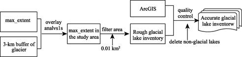
Figure
1 Flow chart of glacial lake cataloging
3.2.2 Classification System of Glacial
Lakes
The
classification of glacial lakes is essential to understand the formation
mechanism and evolution process of glacial lakes. The characteristics of
glacial lakes, including the lake formation process, shape of the lake basin,
type of lake dams or material composition, and replenishment water source, are
the bases of the classification system of glacial lakes. Combined with existing
studies, the classification system can be summarized into two types. The first
type is based on the relationship between glacial lakes and glaciers. When Chen
et al.[17] researched the
inter-annual variations of high mountain Asian glacial lakes, the lakes were
divided into four types: ice-marginal, proglacial, supraglacial, and
unconnected glacial lakes. The other type is based on the formation mechanism
of glacial lakes; Wu et al.[21]
divided glacial lakes in the Hindu Kush-Himalayan region into three categories
(ice-eroded, moraine-dammed, and ice-dammed lakes) and 10 subcategories. In
general, accurate determination of the formation mechanism of glacial lakes
based on remote sensing images only is difficult. The glacial lake
classification system used in this research is based on the relationship
between glacial lakes and glaciers (Table 3). This classification system can
reflect the important role that glaciers play in the formation of glacial
lakes. To obtain reliable classification results, we superimposed high-resolution
remote sensing images and RGI 6.0 glacier contours to distinguish glacial
lakes.
Table 3 Classification system of glacial lakes
|
Types of glacial lake
|
Introduction
|
|
Non-glacier-fed lake (NGFL)
|
Lakes without modern glacial meltwater supply
|
|
Glacier-fed lake (GFL)
|
Supraglacial (SGL)
|
Lakes developed on glacier surface
|
|
Ice-uncontacted lake (IUL)
|
Lakes not contacting the glacier but fed directly by glacial meltwater
|
|
Ice-contacted lake (ICL)
|
Lakes contacting the glacier terminal or margin
|
3.2.3 Uncertainty Assessment of Glacial
Lake Area
Affected
by the attributes of remote sensing products (such as spatial resolution,
cloud-covered, water extraction algorithm, etc.), prior knowledge of visual
interpretation personnel, subjectivity of operation, identification criteria
for glacial lakes, and minimum area thresholds of glacial lake inventories,
inevitable errors will occur in the cataloguing of glacial lakes. This research
adopted a semi-automatic method to map the inventory of glacial lakes and verified
or edited each lake. However, no reasonable and quantifiable indicator is
available for the manual correction process. Therefore, this article assumed
that the area error of the glacial lake caused by manual correction followed a
Gaussian distribution, and only the extraction error of the glacial lake area
caused by the spatial resolution of the remote sensing product was considered.
The research showed that the mixed pixels caused by spatial resolution are the
key factor of the error source, and the error of one pixel on both sides of the
delineated lake boundary was used[22]. Therefore, the uncertainty of
the area of a single lake is follows:
 (1)
(1)
 (2)
(2)
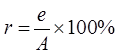
|
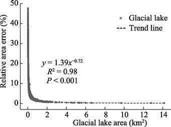
Figure 2 Relative area error of glacial lake
|
where
e is the absolute area error of each
glacial lake (m2), n is
the number of pixels on the glacial lake boundary (approximately the ratio of
the lake perimeter to the spatial resolution), and m is the area of each pixel
of the remote sensing product (the spatial resolution of the GSW dataset is 30
m; thus, m = 900 m2); r
is the relative error of a single lake, and A
is the area of the lake. The area error obtained from the above equation shows
that the total absolute area error of Asian glacial lakes is 98.91 km2,
the average relative error is 19.1%, and the relative area error of each lake
is between 0.2% and 47.7%. Figure 2 shows the relationship between the relative
area error of each glacial lake and the size of glacial lake. The change trend
revealed that the relative area error of the glacial lake has a significant
power function relationship with the size of glacial lake, that is, with the
increase in the area of a glacial lake, the relative area error presents a
decreasing trend. The analysis showed that when the areas of glacial lakes are
0.02, 0.06, and 0.15 km2, the relative area errors are 20%, 10%, and
5%, respectively.
4 Data Results
4.1 Dataset Composition
The dataset is the spatial distribution data and
statistical table data of the max_extent of Asian glacial lakes. The spatial
data included the max_extent data (.shp) of different types of glacial lakes in
Asia from 1980s to 2019. The table data included the statistics of the number
and area of glacial lakes of different sizes, types, and elevation scales in
Asia from 1980s to 2019.
4.2 Data Results
4.2.1 Regional Distribution
Characteristics of Glacial Lakes in the Asia
Based on the GSW dataset, 17,213 glacial lakes (??
0.01 km2) were identified in Asia, with a total area of about 1,299.06
?? 98.91 km2. The glacial lakes are widely distributed and clustered
and are mainly distributed in the Tibet Plateau and adjacent mountains, such as
the Himalayas, Tianshan, and Kunlunshan (Figure 3). Glacial lakes are also
distributed in low-elevation areas, such as the Kamchatka Peninsula. In
general, the glacial lakes in Asia are mainly small lakes with an area between
0.01–14.27 km2; several larger glacial lakes are all located in the
Himalayas. The glacial lakes with an area of less than 0.1 km2 accounted
for about 85.3% of the total number, but their areas accounted for 35.7% of the
total area. The glacial lakes with an area of more than 0.1 km2
accounted for 14.7% of the total number, but their areas accounted for 64.3%.
Therefore, although Asia has numerous small glacial lakes, the total area of
glacial lakes in this region is still dominated by larger lakes (Figures 4a, 4b).
Figures 3, 4c, and 4d show the spatial
distribution, the number, and area of different types of glacial lakes,
respectively. Different types of glacial lakes varied significantly, of which
the GFLs far exceeded non-glacier-feeding
lakes (NGFLs), accounting for 82.2% of the number and 87.5% of the area.
Specifically, among the four types of glacial lakes, the number of non-contacting lakes (IULs) was the
largest, accounting for about 53.6%,
|
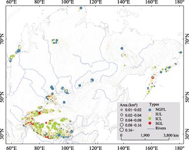
Figure 3 Spatial distribution
characteristics of glacial lakes of different sizes and types in Asia from
1980s to 2019
|
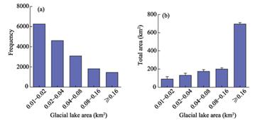
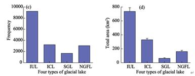
Figure 4 Number and area of glacial
lakes of different sizes (a–b) and
types (c–d) in Asia from
1980s to 2019
(Note:
IUL, ICL, SGL, and NGFL indicate glacier non-contacting lakes, glacier contacting lakes, super-glacier
lakes, and non-glacier-feeding lakes, respectively)
whereas
the proportions of glacier contacting
lakes (ICLs), super-glacier
lakes (SGLs), and NGFLs were relatively small, accounting for 18.8%,
9.8%, and 17.8%, respectively. In terms of glacial lake area, the four types of
glacial lakes (IULs, ICLs, SGLs, and NGFLs) accounted for 57.0%, 25.5%, 5.0%,
and 12.5%, respectively. Compared with other glacial lakes, the average area of
ICLs is larger mainly because such lakes are connected to the terminus of
glaciers and can evolve with glacial ablation.
4.2.2 Elevation Distribution Characteristics of Glacial Lakes
Elevation
zones with an interval of 1,000 m were defined to analyze the dependence of the
distribution of Asian glacial lakes based on elevation. Figure 5 shows the
distribution of the number and area of Asian glacial lakes at different
elevations. As the elevation increased, the number and area of glacial lakes
were approximately normally distributed.
|
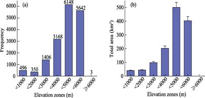
Figure
5 Number (a) and area (b) of glacial lakes in different elevation zones
in Asia from 1980s to 2019
|
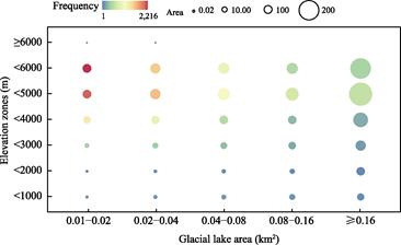
Figure 6 Distribution of glacial lakes
of different sizes in elevation zones with an interval of 1,000 m in Asia
|
Further analysis
showed that in different elevation zones, the distribution of glacial lakes of
different sizes was uneven with significant difference (Figure 6). Glacial
lakes were mainly distributed between 4,000–6,000 m. Most of them were small
lakes (??0.04 km2), whereas larger lakes were distributed in
relatively low-elevation areas mainly because the low-elevation areas are flat
and provide a good water storage environment for certain larger NGFLs and several IULs[10].
All glacial lakes mapped were distributed
in the elevation range of 69–6,044 m, with an average elevation of 4,301 m.
Affected by glacial action, nearly 68.5% of glacial lakes were distributed
between 4,000–6,000 m; the total area of glacial lakes reached the peak value,
which is 503.62 ?? 35.40 km2 (accounting for 38.8% of the total
area), between 4,000–5,000 m (mainly in the Himalayas).
5 Summary
Through
a semi-automatic method, we used the open-source remote sensing product (GSW)
to carry out the spatial cataloging of Asian glacial lakes and compiled an
inventory of different types of glacial lakes. The result analysis showed the
following:
Asia has a wide
area, where a total of 17,213 glacial lakes (??0.01 km2) were
identified with a total coverage area of about 1,299.06 ?? 98.91 km2.
These lakes are mainly distributed in the Tibet Plateau and adjacent mountains,
such as the Himalayas, TianShan, KunlunShan, etc. Asia is dominated by small
glacial lakes; the glacial lakes with an area of less than 0.1 km2
account for about 85.3% of the total number, and the area of a single glacial
lake is between 0.01–14.27 km2. In addition, the number and area of
GFLs far exceed those of NGFLs, accounting for 82.2% and 87.5%, respectively.
The number (53.6%) and area (57.0%) of the IULs are the largest, and the number
(9.8%) and area (5.0%) of the SGLs in this region are the least. Comparatively
speaking, the average area of the ICL is the largest (0.1 km2).
In the vertical
direction, all glacial lakes are distributed in the elevation range of 69–6,044
m, with an average elevation of 4,301 m. Glacial lakes are centrally
distributed at an elevation of 4,000–6,000 m. Within 4,000–5,000 m, the total
area of the glacial lake reached the peak value of 503.62 ?? 35.40 km2.
In addition, in different elevation zones, glacial lakes of various sizes are
unevenly distributed, presenting the characteristics of small glacial lakes at
high average elevation and large glacial lakes at low average elevation.
This research
provides a complete set of max_extent and type spatial distribution data of
glacial lakes in Asia, an effective way to reveal the temporal and spatial
change characteristics of glacial lakes, understand the response of glacial
lakes to climate change, and obtain the data source for subsequent glacial lake
water volume estimation and flash flood research.
Author Contributions
Song, C. Q. made the overall
design for the dataset development; Ma, J. S. collected and processed data on
the max_extent and types of Asian glacial lakes; Wang, Y. J. and Zhang, D. P.
verified the data and directed the paper writing; Ma, J.S. wrote the
manuscript.
Conflicts
of Interest
The
authors declare no conflicts of interest.
References
[1]
Zemp,
M., Huss, M., Thibert, E., et al.
Global glacier mass changes and their contributions to sea-level rise from 1961
to 2016 [J]. Nature, 2019, 568(7752):
382‒386.
[2]
Zemp,
M., Frey, H., Gärtner-Roer, I., et al.
Historically unprecedented global glacier decline in the early 21st century
[J]. Journal of Glaciology, 2015,
61(228): 745‒762.
[3]
Hugonnet,
R., Mcnabb, R., Berthier, E., et al.
Accelerated global glacier mass loss in the early twenty-first century [J]. Nature, 2021, 592(7856): 726‒731.
[4]
Yao,
C., Wang, X., Zhao, X., et al.
Spatial-temporal variation of glacial lakes in the China-Pakistan Economic
Corridor from 1990 to 2018 [J]. Journal
of Glaciology and Geocryology, 2020, 42(1): 33‒42.
[5]
Shugar,
D. H., Burr, A., Haritashya, U. K., et al.
Rapid worldwide growth of glacial lakes since 1990 [J]. Nature Climate Change, 2020, 10(10): 939‒945.
[6]
Veh,
G., Korup, O., Walz, A. Hazard from Himalayan glacier lake outburst floods [J].
Proceedings of the National Academy of
Sciences, 2020, 117(2): 907‒912.
[7]
Luo,
Z., Liu, K., Zhang, C., et al.
Progress of the DEM application for studying lake hydrologic dynamics [J]. Journal of Geo-Information Science,
2020, 22(7): 1510‒1521.
[8]
Wang,
X., Wu, K., Jiang, L., et al. Wide
expansion of glacial lakes in Tianshan Mountains during 1990–2010 [J]. Acta Geographica Sinica, 2013, 68(7):
983‒993.
[9]
Song,
C. Q., Sheng, Y. W., Wang, J. D., et al.
Heterogeneous glacial lake changes and links of lake expansions to the rapid
thinning of adjacent glacier termini in the Himalayas [J]. Geomorphology, 2017, 280: 30‒38.
[10]
Song,
C. Q., Sheng, Y. W. Contrasting evolution patterns between glacier-fed and
non-glacier-fed lakes in the Tanggula Mountains and climate cause analysis [J].
Climatic Change, 2016, 135(3):
493‒507.
[11]
Ma,
J. S., Song, C. Q., Wang, Y. J., et al.
Classification dataset of Asia
glacial lakes and their maximum areas (1980s–2019) [J/DB/OL]. Digital
Journal of Global Change Data Repository, 2021. https://doi.org/10.3974/geodb.2021.11.02.V1.
https://cstr.escience.org.cn/CSTR:20146.11.2021.11.02.V1.
[12]
GCdataPR
Editorial Office. GCdataPR data sharing policy [OL].
https://doi.org/10.3974/dp.policy.2014.05 (Updated 2017).
[13]
Pekel,
J-F., Cottam, A., Gorelick, N., et al.
High-resolution mapping of global surface water and its long-term changes [J]. Nature, 2016, 540(7633): 418‒422.
[14]
Huang,
C., Chen, Y., Zhang, S. Q., et al.
Detecting, extracting, and monitoring surface water from space using optical
sensors: a review [J]. Reviews of
Geophysics, 2018, 56(2): 333‒360.
[15]
Wang,
X., Guo, X., Yang, C., et al. Glacial
lake inventory of high-mountain Asia in 1990 and 2018 derived from Landsat
images [J]. Earth System Science Data,
2020, 12(3): 2169‒2182.
[16]
Yao,
X., Liu, S., Han, L., et al.
Definition and classification system of glacial lake for inventory and hazards
study [J]. Journal of Geographical
Sciences, 2018, 28(2): 193‒205.
[17]
Chen,
F., Zhang, M., Guo, H., et al. Annual
30-meter Dataset for Glacial Lakes in High Mountain Asia from 2008 to 2017 [J].
Earth System. Science. Data, 2020,
13(2): 741‒766.
[18]
Wood,
J. L., Harrison, S., Wilson, R., et al.
Contemporary glacial lakes in the Peruvian Andes [J]. Global and Planetary Change, 2021, 204: 103574.
[19]
Worni,
R., Huggel, C., Stoffel, M. Glacial lakes in the Indian Himalayas—From an
area-wide glacial lake inventory to on-site and modeling-based risk assessment
of critical glacial lakes [J]. Science of
the Total Environment, 2013, 468‒469: S71–S84.
[20]
Buckel,
J., Otto, J. C., Prasicek, G., et al.
Glacial lakes in Austria??Distribution and formation since the Little Ice Age
[J]. Global and Planetary Change,
2018, 164: 39‒51.
[21]
Wu,
L., Xin, L., Liu, S., et al. Remote
sensing based glacial lake inventory in the Hindu Kush-Himalaya region [C].
2011 International Conference on Remote Sensing, Environment and Transportation
Engineering, 2011.
[22]
Krumwiede,
B. S., Kamp, U., Leonard, G. J., et al.
Recent Glacier Changes in the Mongolian Altai Mountains: Case Studies from
Munkh Khairkhan and Tavan Bogd [M]. Global Land Ice Measurements from Space,
2014.