Pan-Antarctic Emperor Penguin Colony Dataset (2000,
2014, 2018)
Zhang, M.1, 2 Li, X. L.2*
1. College of Global Change and Earth System Science,
Beijing Normal University, Beijing 100875, China;
2. University Corporation for Polar Research, Beijing
100875, China
Abstract: The emperor penguin (Aptenodytes forsteri) is regarded as a
??biological indicator?? of Antarctic climate change. Precise colony location is
used as the basis for analyzing the impact of climate change on emperor penguin
population dynamics. Combined with historical high-resolution emperor penguin
colony results, we used Landsat-7 ETM+ and Landsat-8 OLI to generate a dataset
of pan-Antarctic emperor penguin colonies for 2000, 2014, and 2018, respectively.
Visual interpretation methodology was used to identify areas covered by emperor
penguin feces. The generated dataset includes location data for all emperor
penguin colonies, archived in point and surface types, and the Landsat image
names of the emperor penguin colonies, archived in .xlsx and .shp format.
Keywords: emperor penguin;
Antarctica; Landsat; remote sensing; climate change
Dataset Availability Statement:
The
dataset supporting this paper was published and is accessible through the Digital Journal of Global
Change Data Repository at: https://doi.org/10.3974/geodb.2020.05.06.V1.
1 Introduction
Its unique geographical location means that the Antarctic
region is relatively unaffected by human activities and has a simple ecological
structure, which is extremely sensitive to global climate change[1]. Seabirds are a reliable indicator of
environmental change because they are sensitive to a variety of terrestrial and
marine environmental factors[2]. The pan-Antarctic emperor penguin (Aptenodytes forsteri) is regarded as a ??biological indicator?? of
ecological environmental change in the Southern Ocean[3-4]. However, identification of the exact location
of emperor penguin colonies is required to estimate the population size and to
provide basic data for studying the relationship between emigration in emperor
penguin colonies and climate change.
Current
data on emperor penguin colonies mainly include satellite, aerial, and field data[5-8]. Fretwell and Trathan[3] mapped pan-Antarctic emperor penguin colony locations
for the year 2000 using Landsat ETM+, providing the first satellite-based
mapping data, and discovered 38 emperor penguin colonies. Fretwell et al.[9] then
used high-resolution satellite
images to identify the area occupied by emperor penguins, and established a
regression relationship with the number of emperor penguins based on field
observations. This first use of remote sensing data to estimate the number of emperor
penguins around Antarctica provided an estimate of about 238,000 pairs. Aerial
survey also has high resolution as a supplementary means of field
investigation, and can identify some colonies covered by shelter whilst
effectively avoiding human interference with the penguins. Schmidt and Ballard[10] used aerial data to conduct long-term
observations of the emperor penguin population at Cape Crozier. The results
indicated that the fast ice at Cape Crozier broke ahead of time in 2018,
leading to the disappearance of a large number of young emperor penguins.
Based
on Landsat-7 and Landsat-8 images combined with historical emperor penguin
colony locations, we mapped emperor penguin colony data for 2000, 2014, and
2018, respectively, to provide a database for Antarctic emperor penguin
research.
2 Metadata of
the Dataset
The metadata of the ??Pan-Antarctic emperor penguin colony
dataset??[11] is summarized in Table 1. It includes the full name and
short name of the dataset, the authors, spatial resolution, and the data
format, size, files, publisher, and sharing policy, etc.
Table 1 Metadata
summary of the ??Pan-Antarctic emperor penguin colony dataset (2000, 2014, 2018)??
|
Items
|
Description
|
|
Dataset full name
|
Pan-Antarctic emperor penguin colony
dataset (2000, 2014, 2018)
|
|
Dataset short name
|
PanAnta.PenguinColony
|
|
Authors
|
Zhang, M. AAT-6690-2020, Beijing Normal University,
zhmiao6353@163.com
Li, X. L. AAT-9471-2020, Beijing Normal University, xianglanlicn@gmail.com
|
|
Geographical region
|
Pan-Antarctic
|
|
Years
|
2000, 2014, 2018 Temporal
resolution 16 days Spatial resolution 15 m
|
|
Data format
|
.xlsx, .shp Data size 142 KB (after compression)
|
|
Data files
|
(1) E.Penguin_colony_shapefile,
Emperor penguin colony location
data, including all colony location data, including colony area and point
data in 2000, 2014 and 2018;
(2)
Geolocation_E.PenguinColony tables in 2000, 2014 and 2018; (3) Landsat images?? codes of emperor penguin colony in
2000, 2014 and 2018
|
|
Foundation
|
Ministry
of Science and Technology of P. R. China (2018YFC1406906)
|
|
Computing environment
|
ENVI IDL, ArcGIS
|
|
Data publisher
|
Global Change Research Data Publishing &
Repository, http://www.geodoi.ac.cn
|
|
Address
|
No. 11A, Datun Road, Chaoyang District, Beijing 100101,
China
|
|
Data sharing policy
|
Data from the Global Change
Research Data Publishing &Repository includes metadata, datasets (in the Digital Journal of Global Change Data Repository), and publications
(in the Journal of Global Change Data & Discovery). Data sharing
policy includes: (1) Data are openly available and can be free
downloaded via the Internet; (2) End users are encouraged to use Data subject
to citation; (3) Users, who are by definition also value-added service
providers, are welcome to redistribute Data subject to written
permission from the GCdataPR Editorial Office and the issuance of a Data
redistribution license; and (4) If Data are used to
compile new datasets, the ??ten per cent principal?? should be followed such
that Data records utilized should not surpass 10% of the new
dataset contents, while sources should be clearly noted in suitable places in
the new dataset[12]
|
|
Communication and
searchable system
|
DOI, DCI, CSCD, WDS/ISC, GEOSS, China GEOSS, Crossref
|
3 Methods
Landsat-7 and Landsat-8 images were downloaded from the
United States Geological Survey[13] (Table 2). The product level was
level 1 and the revisit cycle was 16 days. The multispectral band resolution
was 30 m and the panchromatic band resolution was 15 m. There were not enough
images for 2000, and we therefore used images downloaded from 1999 to 2003. For 2014 and 2018, we chose images for the
breeding season from September to October. Emperor penguins return to the
colony in March or April and leave the colony in November or December. Because
they feed mainly on Antarctic krill, their feces are brown. The location of the
colony can thus be located according to area of feces during the breeding
season.
Table 2 Landsat
data profiles
|
Time
|
Sensor
|
Resolution (m)
|
Bands
|
Image date
|
|
2000
|
ETM+
|
30/15
|
1, 2, 3
|
1999.9-2003.3
|
|
2014
|
OLI
|
30/15
|
2, 3, 4
|
2014.9-2014.10
|
|
2018
|
OLI
|
30/15
|
2, 3, 4
|
2018.9-2018.10
|
3.1
Algorithm Principle
Several months of accumulated emperor penguin feces appear
brown on Landsat nature color images, in contrast to the main Antarctic
features of water, snow, and ice. The most recent high-resolution pan-Antarctic
emperor penguin colony locations were mapped in 2009, using high-resolution
satellite data. However, some colony locations have since been updated and some
new colonies discovered using aerial data and high-resolution satellite data.
We therefore updated the pan-Antarctic emperor penguin colony locations using a
combination of high-resolution colony location and visual interpretation.
3.2 Technical
Route
The Landsat level 1 product was corrected by geometric and
terrain correction. The difference in accessing times of the images led to
differences in parameters such as sun-earth distance and solar elevation. We
therefore transformed the original image from digital number to top of
atmosphere reflectance (TOA), to effectively eliminate the error due to these
factors in image analysis and to maintain good comparability among the various
images. To achieve higher resolution data, we used Gram-Schmidt Spectral
Sharpening to enhance the 30 m multispectral
band with a 15 m panchromatic band. We identified emperor penguin feces by
visual interpretation in nature color images and analyzed colonies based on
high-resolution historical locations (Figure 1). Landsat image names
corresponding to identify emperor penguin colonies were recorded, and corresponding
vector maps were drawn for each colony.
4 Data Results and Validation
4.1 Data Composition
The
dataset consists of three parts (Table 3):
(1)
emperor penguin colony location data in .shp files in 2000, 2014 and 2015 both
in points and polygons, i.e., the area corresponding to emperor penguin feces
in the breeding season;
(2)
places list of the emperor penguin colony in 2000, 2014 and 2018; and
(3)
Landsat images?? codes corresponding to each emperor penguin colony in 2000,
2014 and 2018.
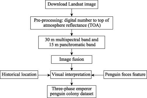
Figure
1 Workflow chart of
data analysis
Table 3 Descriptions
of the data composition of pan-Antarctic emperor penguin colonies
|
Dataset
|
Description
|
|
Vector data of the emperor
penguin colony location
|
Emperor penguin colony location was the area
corresponding to emperor penguin feces in the breeding season. The location
was stored as a point and the area of the colony was stored as surface types
(.shp)
|
|
Table of emperor penguin colony
location
|
Places list of the emperor penguin colony in 2000, 2014
and 2018, including location names both in Chinese and English, as well as
their geo-locations.
|
|
Landsat images using for the study
|
The variable Antarctic weather made it difficult to
obtain high-quality images covering the emperor penguin colonies. The dataset
selected relatively clear images as far as possible to allow users to analyze
the original data. The dataset records (.xlsx) the image names selected for
each colony
|
4.2 Data Results
We recorded 43, 49,
and 42 colonies in 2000, 2014 (Table 4, Figure 2), and 2018, respectively.
Table
4 List
of places of emperor penguin colony in 2014
|
Colony location
|
Colony
location
|
Colony
location
|
|
Astrid Coast
|
Dawson-Lambton Glacier
|
Ragnhild
|
|
Atka Bay
|
Dibble Glacier
|
Riiser Larsen
|
|
Auster Islands
|
Dolleman Island
|
Rothschild
|
|
Barrier Bay
|
Drescher Inlet
|
Rupert Coast
|
|
Bear Peninsula
|
Franklin Island
|
Sabrina Coast
|
|
Beaufort Island
|
Gould Bay
|
Sanae
|
|
Bowman Island
|
Gunnerus Bank
|
Shackleton Ice Shelf
|
|
Brownson Islands
|
Halley Bay
|
Smith Peninsula
|
|
Bryan Coast
|
Haswell Island
|
Smyley Island
|
|
Burton Ice Shelf
|
Lazarev Ice Shelf
|
Smyley Island2
|
|
Cape Colbeck
|
Ledda Bay
|
snow hill Island
|
|
Cape Crozier
|
Luitpold Coast
|
Stancomb Wills
|
|
Cape Darnley
|
Mertz Glacier East
|
Thurston Glacier
|
|
Cape Roget
|
Mertz Glacier West
|
Thurston Glacier2
|
|
Cape Washington
|
Noville Peninsula
|
Umbeashi Rock
|
|
Coulman Island
|
Peterson Bank
|
West Ice Shelf
|
|
Davis Bay
|
|
|
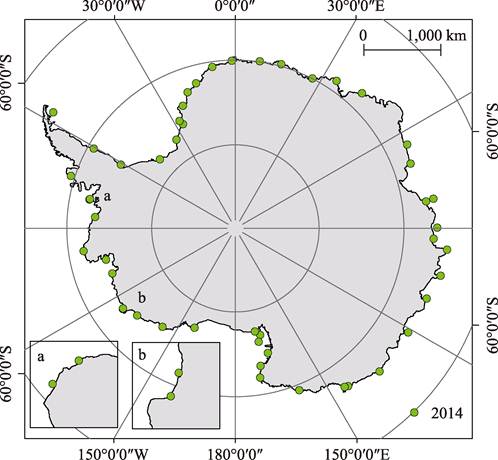
Figure 2 Pan-Antarctic emperor penguin colony locations in 2014, based on
vector point file
The
results showed that emperor penguin colonies were located all around
Antarctica. Emperor penguins mainly breed on fast ice near islands, icebergs,
or ice cliffs (Figure 3), which can act as a barrier to Antarctic winter snow and
wind. Few emperor penguin colonies were located on ice shelf, such as the
Shackleton Ice Shelf in 2018.
|
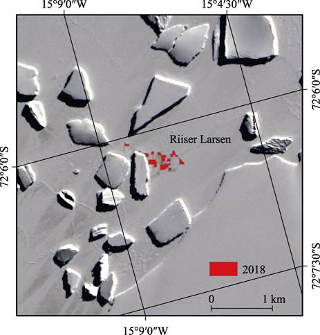
Figure 3 Riiser Larsen colony in 2018
(red area presents
emperor penguin colony)
|
4.3 Data Validation
Fretwell and Trathan[3] identified 38 penguin colonies in 2000. Five of
these 38 known sites were thought to be still extant, because they were confirmed
in report[14]. The current dataset confirmed 43 emperor penguin colonies
in 2000. 32 of the 38 colonies identified by Fretwell and Trathan[3]
were identified, but the Amundsen Bay colony was not determined. We identified
a further 11 emperor penguin colonies combined with historical locations,
including two colonies not identified by Fretwell and Trathan[3]
through satellite images, at Cape Crozier and Auster Islands. We identified 49
emperor penguin colony locations in 2014. Compared with the historical
high-resolution results, seven colonies were not confirmed[15]. However, we identified two new colony
locations, at Smyley Island2 and Thurston Glacier2, close to the Smyley Island
and Thurston Glacier colonies, respectively. Due to their close proximities,
Smyley Island and Smyley Island2, and Thurston Glacier and Thurston Glacier2,
might both comprise single large colonies, respectively. We identified 42 emperor
penguin colony locations in 2018, 12 colonies of which were not confirmed compared
with the historical high-resolution results.
5 Discussion
and Conclusion
The current dataset includes the locations of emperor
penguin colonies in three different years. The dataset also analyzed the
emperor penguin colonies recorded in 2000 in light of the identification of new
colonies in recent years[16-17]. Information on the historical location of emperor penguin
colonies is needed to analyze their emigration, and the 2000 dataset thus
supplies a historical basis against which to analyze the locations of newly
discovered colonies. High-resolution data previously identified 54 emperor penguin
colonies[15]; however, a lack of long-term observations of emperor
penguin colonies has led to insufficient data to support the analysis of any
changes. The remote sensing identification of pan-Antarctic emperor penguin
colonies is mainly limited by image resolution and weather factors (cloud and
snow cover), and selecting clear images covering penguin colonies is therefore
necessary. Results from 2014 and 2018 were used to update the historical
emperor penguin colony locations. Snow cover will also tend to mask the appearance
of penguin feces, thus affecting colony identification, while sheltering
features around the colony may mean that some are missed by satellite data
observations[17]. The current dataset indicates that most emperor penguin
colony locations remained stable over a period of nearly 20 years, though some
colony locations changed due to environmental changes, such as ice shelf
collapse.
The
present pan-Antarctic emperor penguin colony locations were mapped based on high-resolution
satellite images taken in 2009; however, future, high-resolution results can
also be compared with the dataset. The number of Antarctic emperor penguin colony
locations is thus still uncertain. The study of emperor penguin colony
locations is focus on two field: (1) the identification of new colony
locations; and (2) the emigration of already known colonies. The current study
used free Landsat data; however, this has relatively low resolution, while
high-resolution data from abroad is expensive to obtain. Emperor penguins breed
in the Antarctic winter, leading to difficulties in field investigations during
the breeding season. It is hoped that relevant domestic polar satellites can be
used to promote research on Antarctic penguins in the future.
Author Contributions
Zhang, M. and Li, X. L. designed the
dataset processing; Zhang, M. collected and processed the images; Zhang, M.
designed the model and algorithm; Zhang, M. validated the dataset; Zhang, M.
wrote the paper.
References
[1]
He, H., Li,
X. L., Cheng, X., et al. Aerial
photography based estimation of greenhouse gas emissions from penguins in
Victoria Land, Antarctica [J]. Chinese
Science Bullitin, 2016, 61: 3268?C3277.
[2]
Che-Castaldo,
C., Jenouvrier, S., Youngflesh, C., et al.
Pan-Antarctic analysis aggregating spatial estimates of Ad??lie penguin
abundance reveals robust dynamics despite stochastic noise [J]. Nature Communication, 2017, 8(1): 832.
[3]
Fretwell, P.
T., Trathan, P. N. Penguins from space: faecal stains reveal the location of
emperor penguin colonies [J].
Biogeography, 2009, 18(5): 543‒552.
[4]
Ji, M.,
Zhang, B. G., Zhang, Y. Y., et al.
Sizing and trend analysis of penguin numbers in Antarctic from high resolution
photography by unmanned aerial veilles [J]. Journal
of Beijing Normal University (Natural
Science), 2019, 55(1): 25‒35.
[5]
Schiel, R.,
GüPner, F., Spitzenberger, H. J. Population size and condition of the Emperor
Penguin Aptenodytes forsteri colony of Snow Hill Island, Weddell Sea,
Antarctica: observations from 29 December 2018 [J]. Marine Ornithology, 2019, 47: 189‒192.
[6]
Fretwell, P.
T., Trathan, P. N. Emperors on thin ice: three years of breeding failure at
Halley Bay [J]. Antarctic Science,
2019, 31: 133‒138.
[7]
Kooyman, G.,
Ponganis, P. J. Rise and fall of Ross Sea emperor penguin colony populations:
2000 to 2012 [J]. Antarctic Science,
2017, 29(3): 201‒208.
[8]
Todd, F. S.,
Adie, S., Splettstoesser, J. F. First ground visit to the emperor penguin
Aptenodytes forsteri colony at Snow Hill Island, Weddell Sea, Antarctica [J]. Marine Ornithology, 2004, 32: 193‒194.
[9]
Fretwell, P.
T., Larue, M. A., MORIN, P., et al.
An emperor penguin population estimate: the first global, synoptic survey of a
species from space [J]. PLoS One,
2012, 7(4): e33751.
[10]
Schmidt, A.
E., Ballard, G. Significant chick loss after early fast ice breakup at a
high-latitude emperor penguin colony [J]. Antarctic
Science, 2020, 32(3):180-185.
[11]
Zhang, M.,
Li, X. L. Pan-Antarctic emperor penguin colony dataset (2000, 2014, 2018) [J/DB/OL].
Digital Journal of Global Change Data
Repository, 2020. https://doi.org/10.3974/geodb.2020.05.06.V1.
[12]
GCdataPR
Editorial Office. GCdataPR data sharing policy [OL].
https://doi.org/10.3974/dp.policy.2014.05 (Updated in 2017).
[13]
United
States Geological Survey (USGS) [DB/OL]. https: //earthexplorer.usgs.gov/.
[14]
Wienecke, B.
Emperor penguin colonies in the Australian Antarctic Territory: how many are
there? [J]. Polar Record, 2009, 45(235):
304‒312.
[15]
Ancel, A.,
Cristofari, R., Trathan, P. N., et al.
Looking for new emperor penguin colonies? Filling the gaps [J]. Global Ecology and Conservation, 2017,
9: 171‒179.
[16]
Larue, M. A.,
Kooyman, G., Lynch, H. J., et al.
Emigration in emperor penguins: implications for interpretation of long-term
studies [J]. Ecography, 2015, 38(2):
114‒120.
[17]
Ancel, A.,
Cristofari, R., Fretwell, P. T., et al.
Emperors in hiding: when ice-breakers and satellites complement each other in
Antarctic exploration [J]. PLoS One, 2014, 9(6): e100404.