Spatial Distribution Dataset of Continuously
Disappearing Surface Water in China (1980s‒2019)
Zhang, D. P.1,2 Jing, H. T.1 Liu, K.2 Ma, J. S.1,3 Xu, J. H.1,2
Song, L. J.1,2 Song, C.
Q.2*
1. School of
Surveying and Land Information Engineering, Henan Polytechnic University,
Jiaozuo 454000, China;
2. Key Laboratory
of Watershed Geographic Sciences, Nanjing Institute of Geography and Limnology,
Chinese Academy of Sciences, Nanjing 210008, China;
3. School
of Geographical Sciences, Nanjing University of Information Science and
Technology, Nanjing 210044, China
Abstract:
Surface water
is an important water source for human life and production and plays a
significant role in maintaining ecological security and environmental health.
In recent years, subject to the dual influence of global climate change and
people??s overuse of water resources, changes in surface water in China
demonstrated different temporal and spatial characteristics, of which the
disappearance of surface water is the most distinct. In this research, based on
the JRC (Joint Research Centre) Global Surface Water dataset, the spatial
distribution scope of continuously disappearing water bodies larger than 0.1 km2
in China for the period of 1980s–2019 was extracted, and the
continuously disappearing water bodies were divided into four types, namely,
lakes, rivers, coastlines, and others. Then, combining artificial reading and
interpretation and quality control, a spatial distribution dataset of
continuously disappearing water bodies in China for the period of 1980s–2019
was formed. The spatial data included the distribution data of continuously
disappearing water bodies in China for the period of 1980s–2019
(.shp), and the table data included the type and area statistics of
continuously disappearing water bodies in China for the period of 1980s–2019.
The dataset was archived in .shp and .xlsx formats, consisting of nine data
files with data size of 13.30 MB (compressed into a 9.24 MB file).
Keywords: continuously disappearing; permanent water; surface
water; spatial characteristics
DOI: https://doi.org/10.3974/geodp.2022.02.13
CSTR: https://cstr.escience.org.cn/CSTR:20146.14.2022.02.13
Dataset Availability Statement:
The dataset supporting this paper
was published and is accessible through the Digital
Journal of Global Change Data Repository at: https://doi.org/10.3974/geodb.2021.11.03.V1 or
https://cstr.escience.org.cn/CSTR:20146.11.2021.11.03.V1.
1 Introduction
Surface
water is a key link in the global water cycle, influencing energy balance on the
earth??s surface[1]. Moreover, surface water is the most important
water source for human life and production and has an important social value.
In recent decades, subject to the dual influence of global climate change and
human activities, changes in surface water demonstrated different temporal and
spatial patterns[2], of which the shrinkage and complete
disappearance of surface water bodies are the most distinct[3]. For
example, Baiyang Lake dried up in the 1980s[4], main streams of the
Yellow River frequently dried up in the 1990s[5], and lakes in Inner
Mongolian have been rapidly shrinking and disappearing since the beginning of
the 21st century[6]. These examples of disappearing
surface water bodies pose a serious threat to the security of regional water
resources and may lead to serious ecological and environmental problems, such
as loss of the water bodies?? ecological service functions, land desertification
and salinization, a reduction in biodiversity, and so on[7]. Thus,
monitoring and conducting quantitative analyses on regions with disappearing
surface water bodies are important and would have academic significance and
application value. Scholars conducted considerable research on dynamic changes
in surface water bodies[8,9]. Specifically, utilizing remote sensing
data and technical methods, they revealed the temporal-spatial change patterns
of surface water bodies at different scales[10]. Existing studies
focused mainly on analyzing the shrinkage and disappearance of water bodies[11,12],
especially via statistical analysis. However, few data products are dedicated
to disappearing water bodies at present.
China is a vast
territory with diversified climates, uneven water resource distribution[13],
and unbalanced regional development. In recent years, against the background of
climate change and rapid economic and social development, significant changes
in the distribution characteristics of surface water bodies in China were
observed. On the whole, under the guidelines and policies for ecological civilization
construction, the shrinkage and degeneration trend of lakes, wetlands, rivers,
and other surface water bodies were contained and improved, but the shrinkage
and disappearance of surface water bodies remain serious ecological and
environmental problems in certain regions. In this research, we introduce the
concept of continuously disappearing surface water bodies, that is, surface
water that was a permanent water body at the starting year of the research
period but continuously shrank throughout the years until the end of the
research period. In the JRC Global Surface Water (GSW) dataset, permanent water
bodies refer to those with water all year round[7]. In this study,
we take the permanent disappearing water bodies larger than 0.1 km2
in China for the period of 1980s–2019 in the JRC GSW dataset as continuously
disappearing water bodies then divide them into four types, namely, lakes,
rivers, coastlines, and others. Finally, we establish a spatial distribution
dataset of continuously disappearing water bodies in China for the period of
1980s–2019. Such data can reveal the spatial characteristics of continuously
disappearing surface water in China in the past two decades, which can provide
basic information for the sustainable development of water resources and
environmental governance in the future.
2 Metadata of the Dataset
The metadata of the Dataset of surface persistent disappearing water in
China (1980s-2019)[14] is summarized in Table 1. It includes the dataset full name, short
name, authors, year of the dataset, temporal resolution, spatial resolution,
data format, data size, data files, data publisher, and data sharing policy, etc.
Table 1 Metadata summary of the Dataset of surface persistent
disappearing water in China (1980s-2019)
|
Items
|
Description
|
|
Dataset full name
|
Dataset of surface persistent disappearing water in China (1980s‒2019)
|
|
Dataset short
name
|
DisappearingWaterChina_1980s-2019
|
|
Authors
|
Zhang, D. P.,
School of Surveying and Land Information Engineering, Henan Polytechnic
University, Key Laboratory of Watershed Geographic Sciences, Nanjing
Institute of Geography and Limnology, Chinese Academy of Sciences, zdp_1994@163.com
Jing, H. T.,
School of Surveying and Land Information Engineering, Henan Polytechnic
University, jht_6153@163.com
Liu, K., Key Laboratory of Watershed Geographic
Sciences, Nanjing Institute of Geography and Limnology, Chinese Academy of
Sciences, kliu@niglas.ac.cn
Ma, J. S., School of Geographical Sciences, Nanjing University of
Information Science and Technology, Nanjing 210044, China;
20191210011@nuist.edu.cn
Xu, J. H., School
of Surveying and Land Information Engineering, Henan Polytechnic University,
Key Laboratory of Watershed Geographic Sciences, Nanjing Institute of
Geography and Limnology, Chinese Academy of Sciences,
jiahui_x1996@163.com
Song, L. J., School
of Surveying and Land Information Engineering, Henan Polytechnic University,
Key Laboratory of Watershed Geographic Sciences, Nanjing Institute of
Geography and Limnology, Chinese Academy of Sciences, lijuansong88888@163.com
Song, C. Q., Key
Laboratory of Watershed Geographic Sciences, Nanjing Institute of Geography
and Limnology, Chinese Academy of Sciences, cqsong@niglas.ac.cn
|
|
Geographical
region
|
China
|
|
Year
|
1980s–2019
|
Spatial
resolution
|
30 m
|
|
Data format
|
.shp, .xls
|
Data size
|
13.3 MB
|
|
Data files
|
Spatial data:
distribution data of continuously disappearing water in China from 1980s to
2019
Table data: statistics of
types and areas of water continuously disappearing in China from 1980s to 2019
|
|
Foundations
|
Ministry of
Science and Technology of P. R. China (2019YFA0607101); Chinese Academy of
Sciences (XDA23100102)
|
|
Data publisher
|
Global Change Research Data Publishing & Repository,
http://www.geodoi.ac.cn
|
|
Address
|
No. 11A, Datun
Road, Chaoyang District, Beijing 100101, China
|
|
Data
sharing policy
|
Data from the Global Change Research Data
Publishing & Repository includes metadata, datasets (in the Digital Journal of Global
Change Data Repository), and publications (in the Journal of Global
Change Data & Discovery).
Data sharing
policy includes: (1) Data are openly available and can
be free downloaded via the Internet; (2) End users are encouraged to use Data
subject to citation; (3) Users, who are by definition also value-added
service providers, are welcome to redistribute Data subject to written
permission from the GCdataPR Editorial Office and the issuance of a Data
redistribution license; and (4) If Data are used to compile new
datasets, the ??ten per cent principal?? should be followed such that Data
records utilized should not surpass 10% of the new dataset contents, while
sources should be clearly noted in suitable places in the new dataset[15]
|
|
Communication
and searchable system
|
DOI, CSTR, Crossref, DCI,
CSCD, CNKI, SciEngine, WDS/ISC, GEOSS
|
3 Methods
The research processing
method is shown in Figure 1. First, the change data of water bodies in China
were screened from the JRC GSW dataset[7]. Data with a value of 3
were extracted from the layer (disappeared permanent water bodies) and converted
into vector data. Next, the area was calculated, and the surface water body
data with an area of >0.1 km2 were extracted. Second, the vector
data of the lakes, rivers, and coastlines were used to classify the disappeared
water bodies. As different datasets use different processing methods, and
omissions and overlapping among datasets are common, the priority of the
classification was specified as lake>river>coastline. In addition, to
guarantee the integrity and accuracy of the data, the classified water body
data were removed and superposed with a Google image, and patches with an area
of >1 km2 were manually inspected and screened then classified
and combined. The water bodies that could not be judged, did not belong to the
above three types, and had an area of <1 km2 were classified
as??others??. Finally, the disappeared
|
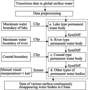
Figure 1 Technical flow chart
|
permanent
water bodies nationwide were classified into four types, namely, lakes, rivers,
coastlines, and others, to form the spatial distribution dataset of
continuously disappearing surface water bodies in China for the period of 1980s–2019
(>0.1 km2).
4 Data Results and Validation
4.1 Data Composition
The
spatial data included the distribution data of continuously disappearing water
bodies in China for the period of 1980s‒2019
(.shp). The table data included the type and area statistics of continuously
disappearing water bodies in China for the period of 1980‒2019. In the attribute table of the
Continuously_disappearing_water.shp dataset, the ID values of 1, 2, 3, and 4 corresponded
to coastline-type disappearing water bodies, lake-type disappearing water
bodies, river-type disappearing water bodies, and other types of disappearing
water bodies, respectively. The dataset, with a data size of 13.30 MB, was
stored in .shp format (compressed into a file with a data size of 9.24 MB).
4.2 Data Products
4.2.1 Distribution of Continuously
Disappearing Surface Water Bodies Nationwide
During
the period of 1980s–2019, a total of 3,870.53 km2 of surface water
disappeared in China, of which the largest continuously disappearing water body
area of 473.72 km2 was observed in Jiangsu province. In this study,
continuously disappearing water bodies were divided into four types, namely,
coastlines, lakes, rivers, and others. Among the disappearing water body types,
the coastlines were the largest, with an area of 2,522.86 km2,
accounting for 65.18% of the total area of disappeared water bodies in the
country and the most dominant type, followed by lakes, with an area of 764.26
km2, accounting for 19.75% of the total area of disappeared water
bodies. The river-type disappearing water bodies had an area of 313.44 km2,
accounting for 8.10% of the total area of disappeared water bodies, whereas the
other disappearing water bodies had an area of 269.97 km2,
accounting for 6.98% of the total area of disappeared water bodies. As shown in
Figure 2, the disappearing water bodies in China were distributed mainly along
the coastlines and in the northeast region.
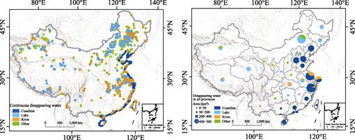
Figure 2 Spatial distribution of
continuously disappearing water bodies in China (1980–2019)
As depicted in
Figure 3, the spatial distribution of continuously disappearing water bodies in
China has been uneven since the 1980s, and the area and proportion of
disappearing water bodies in various provinces demonstrated considerable
differences. Generally, the area of disappearing water bodies in the eastern
region was greater than that of disappearing water bodies in the western
region, and the area of disappearing water bodies in the coastal region was
greater than that of disappearing water bodies in the inland region.
Specifically, the disappearing water bodies were concentrated mainly in five
provinces (municipalities directly under the central government), namely,
Jiangsu province (473.42 km2), Zhejiang province (452.21 km2),
Liaoning province (351.68 km2), Shanghai (369.23 km2),
and the Inner Mongolia autonomous region (455.00 km2), with a total
area accounting for 54.37% of all disappearing water bodies nationwide. The
total area of the disappearing water bodies in Jiangsu province, Liaoning province,
Zhejiang province, and Shanghai exceeded 300 km2, of which
coastlines were the largest disappearing water bodies, with an area exceeding
60% of the total area of the disappearing water bodies in the provinces.
Meanwhile, Jiangsu province had the largest river-type disappearing water
bodies, with an area of 144.98 km2. The main disappearing water
bodies in the Inner Mongolia autonomous region were lakes, with an area of
300.92 km2, accounting for 66.13% of the total area of the
disappearing water bodies in the Inner Mongolia autonomous region. The other
water bodies included marshlands, paddy fields, and so on, which were
distributed mainly in the Inner Mongolia autonomous region, accounting for a small
proportion of the total area of disappearing water bodies. Only the spatial
distribution characteristics and reasons for the disappearance of the
coastline-type, lake-type, and river-type water bodies were included in this
study.
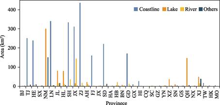
Figure
3 Statistical graph
of areas of continuously disappearing water bodies in various provinces
(Note: The province abbreviation rules in this figure
are as follows: Anhui-AH, Beijing-BJ, Fujian-FJ, Gansu-GS, Guangdong-GD,
Guangxi-GX, Guizhou-GZ, Hainan-HI, Hebei-HE, Henan-HA, Heilongjiang-HL,
Hubei-HB, Hunan-HN, Jilin-JL, Jiangsu-JS, Jiangxi-JX, Liaoning-LN, Inner
Mongoria IM-NM, Ningxia-NX, Qinghai-QH, Shandong-SD, Shanxi-SX, Shaanxi-SN,
Shanghai-SH, Sichuan-SC, Tianjing-TJ, Tibet-XZ, Xinjiang-XJ, Yunnan-YN, Zhejiang-ZJ,
Chongqing-CQ, Macao-MO, Hong Kong-HK, Taiwan-TW. The same as below)
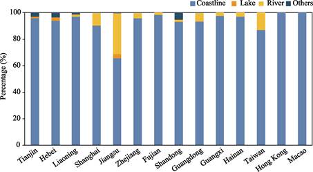
4.2.2 Distribution of Coastline-type
Disappearing Water Bodies
Among
the disappearing water body types, the coastline type was the largest, with an
area of 2,522.86 km2, accounting for 65.18% of the total area of all
disappearing water bodies in the country. The four provinces with the largest
area of coastline-type disappearing water bodies were Zhejiang province (436.54
km2), Liaoning province (340.86 km2), Shanghai (333.34 km2),
and Jiangsu province (311.01 km2), accounting for 56.36% of the
total area of coastline-type disappearing water bodies. As shown in Figure 4,
among the disappearing water body types in the coastal provinces
(municipalities directly under the central government), the coastline type was
the largest.
As presented in Table 2, Zhejiang province
had the largest area of coastline-type disappearing water bodies mainly owing
to the development and construction of Hangzhou Bay. The disappeared water body
area in Hangzhou Bay was 233.31 km2, accounting for 60.57% of the
total area of the disappearing water bodies in Zhejiang province. In 1985, the
main landscape of the Hangzhou Bay wetland included mudflats, shallow waters,
and reed marshes, whereas in 2015, most of the region had been converted into
farmlands, planted forests, and marine culture sites[16]. The newly
reclaimed lands generated considerable
Figure
4 Proportion of
area of various types of water bodies in coastal provinces
Table
2 Summary of provincial unit area of
coastline disappearing water body
|
Area of lake
type disappearing water (km2)
|
Province
|
|
0
|
SX, NM, JL, HL, AH, JX, HA, HB, HN, CQ, SC, GZ, YN, XZ, SN, GS, QH,
NX, XJ
|
|
0–300
|
HK, MO, GX, TW, HI, FJ, GD, SD, HE, TJ
|
|
300–400
|
JS, SH, LN
|
|
400–450
|
ZJ
|
income
for the local residents, and driven by interest, the transformation process
from natural wetlands to artificial wetlands then to impervious beds was
irreversible. At the same time, the reclamation activities facilitated the
rapid washing away of some of the natural silt by the shore current, thereby
resulting in water loss and soil erosion.
4.2.3 Distribution of Lake-type Disappearing Water Bodies
Lakes
are important surface water components and play an indispensable role in the
hydrologic cycle. With human encroachment on lakes, the enhancement of
artificial water diversions in lakes, and lakes?? sensitivity to climate change,
lake shrinkage and expansion are common. The lake type ranked second among the
disappearing water body types, with an area of 764.26 km2,
accounting for 19.75% of the total area of disappearing water bodies
nationwide. The two provinces with the largest area of lake-type disappearing
water bodies were the Inner Mongolia autonomous region (300.92 km2)
and Qinghai province (147.72 km2), accounting for 58.70% of the
total area of lake-type disappearing water bodies. The lake-type disappearing
water bodies were distributed mainly in North and West China.
The Inner
Mongolia Autonomous Region had the largest area of lake-type disappearing water
bodies. In the region, the five lakes with the largest disappeared area were
Daihai Lake (42.03 km2), Xindalainor Lake (31.47 km2),
Chagannor Lake (32.09 km2), Dalinor Lake (28.09 km2), and
Huangqihai Lake (14.54 km2), with a total area accounting for 50.96%
of the total area of the lake-type disappearing water bodies in the Inner
Mongolia autonomous region and 20.41% of the total area of lake-type
disappearing water bodies nationwide. In Qinghai province, Qarhan Salt Lake had
the largest disappearing area (due to salt mining and artificial reforming) of
59.68 km2, accounting for 41.87% of the total area of the lake-type
disappearing water bodies in the province, and was the largest disappearing
water body in China.
Daihai Lake was the largest disappearing
water body in the Inner Mongolia autonomous region, with an area of up to 42.03
km2. Regarding the main background of this change, since the 1990s,
Daihai Lake has been vigorously involved in the development of agriculture,
industry, aquaculture, and tourism in the region. Moreover, the Daihai Power
Plant, cultural farms, and so on were established around Daihai Lake, thereby
substantially increasing lake water consumption. However, in recent years,
precipitation around the Daihai Lake basin decreased, the confluence channel
was blocked, and high temperatures increased
Table 3 Summary of provincial unit area of
lake type disappearing water body
|
Area of lake type disappearing water (km2)
|
Province
|
|
0–1
|
SX, FJ, HA, GD, GX, HI, CQ, GZ, YN, GS, NX, TW, HK, MO, BJ, SH, ZJ, SC, SD, LN
|
|
1–30
|
JX, TJ, HB, HE, BN, SN, JS, AH,
|
|
30–100
|
XZ, XJ, HL, JL
|
|
100–350
|
QH, NM
|
evaporation.
Under the joint influence of natural and social factors, the area of Daihai
Lake continued to shrink. In addition, against the background of global warming
and wetting, the lakes in the northwest region tended to expand, but some lakes
demonstrated the continuously disappearing phenomenon, of which Qarhan Salt
Lake in Qinghai province was the typical representative. During the period of
2002–2018, the rapid development of industrial mining activities in the salt
lake and its surrounding salt pans as well as the influence of human activities
dominated the changes in the water body, thereby resulting in a total loss of
54.28 km2 of natural water.
4.2.4 Distribution of River-type Disappearing Water Bodies
The
river type ranked third among the disappearing water body types, with an area
of 313.44 km2, accounting for 8.10% of the total area of all
disappearing water body types. The two provinces with the largest area of
river-type disappearing water bodies were Jiangsu province (144.98 km2)
and Shanghai (35.18 km2), accounting for 57.48% of the total area of
river-type disappearing water bodies. The river-type disappearing water bodies
were distributed mainly in the lower reaches of the Yangtze River in China.
Table 4 Summary of provincial unit area of
river type disappearing water body
|
Area of river type disappearing water (km2)
|
Province
|
|
0–5
|
BJ, TJ, HE, CQ, GZ, HK, MO, SX, QH, GX, GS, HA, SN, BN, HI, SC, XZ,
NX, TW, JX, FJ, NM, SD, YN
|
|
5–30
|
LN, AH, HL, GD, JL, XJ, ZJ, HB
|
|
30–100
|
SH
|
|
100–200
|
JS
|
The province with
the largest area of river-type disappearing water bodies was Jiangsu province,
at 144.98 km2. The causes of such disappearance were as follows. On
one hand, the estuary of the Yangtze River is located in Shanghai and Jiangsu
province, and the sediment carried by the runoffs of the Yangtze River
accumulates constantly, thereby forming estuary sandbanks. On the other hand,
to meet the requirements of urban expansion, the reclaimed area was increased,
and the reclamation construction of Chongming Island was conducted in 1992 and
1998, which changed the land use type at the estuary of the Yangtze River,
thereby resulting in the continuous reduction of the river water. Therefore,
the water disappearance at the estuary of the Yangtze River was mainly due to
the natural factor of sediment accumulation and human factor of reclamation
activities.
5 Discussion and Conclusion
In
this dataset, the spatial distribution characteristics of continuously
disappearing surface water bodies in China for the period of 1980s‒2019
(>0.1 km2) were provided, and the disappearing water bodies were
divided into four types, namely, coastlines, lakes, rivers, and others. The
statistical analysis showed that during the period of 1980s–2019, a total area
of 3,870.53 km2 of surface water disappeared continuously, of which
coastlines had the largest area (2,522.86 km2), accounting for
approximately three fifths of the total area of disappearing water bodies
nationwide and the most dominant type. The distribution of the disappearing
water bodies demonstrated significant spatial differences. Specifically, the
area of disappearing water bodies in the eastern region was greater than that
of disappearing water bodies in the western region, and the area of
disappearing water bodies in the coastal region was greater than that of
disappearing water bodies in the inland region. In addition, the four provinces
with the largest area of coastline-type disappearing water bodies were Zhejiang
province, Liaoning province, Shanghai, and Jiangsu province, and the provinces
with the largest area of lake-type disappearing water bodies were the Inner
Mongolia autonomous region and Qinghai province. Moreover, the provinces with
the largest area of river-type disappearing water bodies were Jiangsu province
and Shanghai. This dataset provided spatial distribution information for four
types of continuously disappearing water bodies in China for the period of 1980s–2019
and a data foundation for analyzing various types of disappearing water bodies
in different regions. Furthermore, the dataset can provide a scientific
reference for water resource conservation and ecological restoration in various
regions nationwide.
Author Contributions
Song, C. Q. and Jing, H. T. designed the algorithms of dataset. Zhang, D. P.,
Ma, J. S., Xu, J. H. and Song, L. J. contributed to the data processing and
analysis. Zhang, D. P., Liu, K. and Song, C. Q. wrote the
data paper.
Conflicts
of Interest
The authors
declare no conflicts of interest.
References
[1]
Zhan, S.,
Song, C., Wang, J., et al. A global
assessment of terrestrial evapotranspiration increase due to surface water area
change [J]. Earths Future, 2019, 7(3): 266‒282.
[2]
Zhang,
L., Nan, Z., Wang, W., et al.
Separating climate change and human contribu-tions to variations in streamflow
and its components usingeight time-trend methods [J]. Hydrological Processes,
2019, 33: 383‒394.
[3]
Chen, L., Zhang, G., Xu, Y. J., et
al. Human activities and climate variability affecting inland water surface
area in a high latitude river basin [J]. Water, 2020, 12(2): 382.
[4]
Zhang,
M., Gong, Z. N., Zhao, W. J., et al.
Landscape pattern change and driving mechanism of Baiyangdian Wetland in recent
30 years [J]. Acta Ecologica Sinica, 2016, 36(15): 4780‒4791.
[5]
Liu, C.
M., Cheng, L. Runoff sequence analysis of the cut-off in the lower reaches of
the main stream of the Yellow River [J]. Acta Geographica Sinica,
2000(3): 257‒265.
[6]
Yue, D.
Study on water surface area change and ecological effect of large lake wetland
in Inner Mongolia [D]. Hohhot: Inner Mongolia University, 2015.
[7]
Pekel,
J. F., Cottam, A., Gorelick, N., et al.
High-resolution mapping of global surface water and its long-term changes [J]. Nature,
2016, 540: 418–422.
[8] Yi, S., Song, C., Wang,
Q., et al. The potential of GRACE
gravimetry to detect the heavy rainfall-induced impoundment of a small
reservoir in the upper Yellow River [J]. Water Resource Research, 2017,
53(8): 6562‒6578.
[9]
Luo, S.,
Song, C., Liu, K., et al. An
effective low-cost remote sensing approach to reconstruct the long- term and
dense time series of area and storage variations for large lakes [J]. Sensors,
2019, 19: 4247.
[10]
Song, C., Ke,
L. H., Pan, H., et al. Long-term
surface water changes and driving cause in Xiong??an, China: from dense Landsat
time series images and synthetic analysis [J]. Science Bulletin, 2018, 708‒716.
[11]
Zhou, Y.
Analysis of lake changes and their causes in the Mongolian Plateau from 2000 to
2015 [D]. Beijing: China University of Geosciences, 2018.
[12]
Zhuang,
Y. Research on coastline dynamic monitoring based on satellite remote sensing
data [D]. Zhoushan: Zhejiang Ocean University, 2019.
[13]
Liang,
D. J., Guo, R. X. Distribution characteristics of water resources in China and
ideas for solving drought in North China [J]. Arid Land Geography,
1988(1): 4‒9.
[14]
Zhang,
D. P., Jing, H. T., liu, K., et al. Dataset
of surface persistent disappearing water in China (1980s-2019)
[J/DB/OL]. Digital Journal of Global Change Data Repository,
2021. https://doi.org/10.3974/geodb.2021.11.03.V1.
https://cstr.escience.org.cn/CSTR:20146.11.2021.11.03.V1.
[15] GCdataPR Editorial Office. GCdataPR data
sharing policy [OL]. https://doi.org/10.3974/dp.policy. 2014.05 (Updated 2017).
[16] Qiu, L., Zhang, M.,
Zhou, B., et al. Economic and
ecological trade-offs of coastal reclamation in the Hangzhou Bay, China [J].
Ecological Indicators,
2021, 125: 107477.