Global Change Data Encyclopedia
Cuorendejia Lake, Qinghai-Tibet Plateau, China
Gou, Z. J. Liu, F. G.*
Department of Geographic Sciences, Qinghai Normal University, Xining 810008
Keywords: Cuorendejia Lake; Yelusu Lake; Qinghai-Tibet Plateau; Qinghai province; saltwater lake; Chumar River; data encyclopedia
|
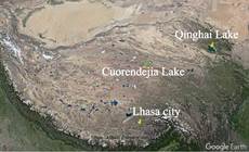
Figure 1 Geo-location of Cuorendejia Lake Data (Google Earth images)
|
Cuorendejia Lake, also known as Yelusu Lake and Dorgaicuo Lake, is located in the Hoh Xil region in the northern Qinghai-Tibet Plateau and administratively belongs to Zhiduo county, Yushu Tibetan putonomous prefecture, Qinghai province, P. R. China. It is 700 km away from Qinghai Lake in the northeast and 620 km away from Lhasa city in the south (Figure 1). Its geo-location is 35°9′30″N-35°16′11″N, 91°55′9″E-
92°18′0″E, with the central point of 35°12′56.53″N, 92°11′12.43″E. The lake is 4,688 m above sea level.
Cuorendejia Lake is 33.8 km long from east to west and 9 km from north to south. In 2015, the lake area is 200.88 km² and the shoreline is 140.24 km in 2015. There are two islands in the lake. The larger one has an area of 0.34 km² and the coastline of 2.40 km, while the smaller one has an area of 0.04 km2 and a coastline of 0.93 km[2]. The lake is deep in the northeast and shallow in the southwest.
The lake is located in the semi-arid region of the alpine grassland in the south of Qinghai province, with an annual average temperature of -6.0–-0.4 oC and annual precipitation of about 200 mm. The north bank of the lake is the southern foot of Bayinguri Old Mountain, and the south bank is desert with many small saline water bodies or wetlands. The water of Cuorendejia Lake mainly comes from the Chumar River which flows through Zhiduo county into the south bank by west of the lake and flows out from the eastern end of the lake. Lake Charendegar is the largest lake that the Chumar River crossed[3].
Cuorendejia Lake is located in the center of Qinghai Hoh Xil National Nature Reserve (34°11′23″N-36°9′35″N, 89°15′0″E-94°2′59″E). Qinghai Hoh Xil Nature Reserve was on the World Heritage List in 2017[4].
The Cuorendejia Lake dataset was developed based on the Google Earth remote sensing satellite images (2015) and related maps. The dataset is archived in .kmz[4] (Figure 2) and .shp[6] formats and consists of 22 data files with a data size of 1.66 MB (compressed in 2 data files with the data size of 607 KB).
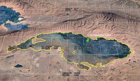
Figure 2 Cuorendejia Lake (.kmz format)
References
[1] Gou, Z. J., Liu, F. G. Cuorendejia Lake [DB/OL]. Global Change Research Data Publishing & Repository, 2018. DOI: 10.3974/geodb.2018.04.20.V1.
[2] Xi’an Surveying and Mapping General Station, Starmap Press. Map of Qinghai Province [M]. Beijing: Starmap Press, 1999.
[3] Hu, D. S. Lake survey in Kekexili region [J]. Journal of Salt Lake Science, 1994, 2(3): 17-21.
[4] https://baike.so.com/doc/6974393-7197082.html.
Data Computing Environment
[5] Google LLC. Google Earth Pro. 7.3.2.5481 (32-bit), hk.google.com.
[6] ESRI. ArcGIS campus license of Institute of Geographic Sciences and Natural Resources Research, Chinese Academy of Sciences.
URL for Data Downloading
http://www.geodoi.ac.cn/WebEn/doi.aspx?Id=933.
Or search through: http://www.geodoi.ac.cn.