Global Change Data Encyclopedia
Paiku Co
Zhao, W. L.1 Chen, Q.1,2*
Liu, F. G.1,2
1. School of Geographical Sciences, Qinghai Normal University,
Xining 810008, China;
2. Academy of Plateau Science and Sustainability, Xining
810008, China
Keywords: Paiku Co; Qinghai-Tibet Plateau; Tibet; data
encyclopedia
Dataset Available Statement:
The dataset supporting this paper was published
at: Zhao, W. L., Chen, Q., Liu, F. G. Paiku
Co [J/DB/OL]. Digital Journal
of Global Change Data Repository, 2020. DOI: 10.3974/geodb.2020.03.23.V1.
Paiku Co, also known as Pogu Lake, Lamuzuhai, Lacoxinco[1], is the largest lake in
Shigatse, Tibet autonomous region, China. The Paiku Co is located at the
junction of Jilong and Nylam in Shigatse. It is inland brackish water lake and
the lake type is tectonic lake[2].
The elevation of the lake is 4,585 m. The geo-location of the Paiku Co is between
28??46??33??N and 29??01??26??N, 85??29??46??E and 85??40??15??E[3] (Figure 1-2).
|
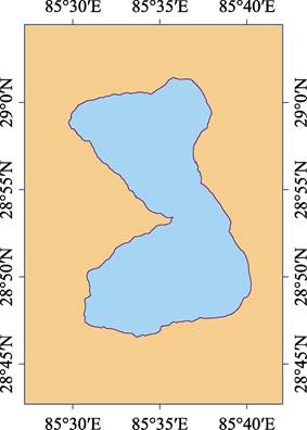
Figure 1 Map of
Paiku Co (.shp format)
|
Paiku Co is located in the western of the rift basin on the
northern foothills of the Himalayas, and surrounded by mountains on the north,
east and west which have steep shores. The south is a flood-lacustrine plain
dotted with arc hills and the terrain is more open[4].
It is like a
gourd with a narrow center and wide ends. There are dozens of visible ancient
lake shorelines in its northeast corner, and the highest lake shoreline is
about 80 m above the level of the modern lake. There are tens of visible paleo-shorelines around Paiku Co with the
highest shoreline about 80 m above the modern lake level,
indicating that the lake has been shrinking since early Holocene[5].
It is about 30 km north of the Yarlung
Zangbo River and about 60 km south is the Xixiabangma Peak at 8,012 m asl. Looking south from the shore of Paiku Co, there is an extremely spectacular cloud waterfall phenomenon
at the northern foot of Xixiabangma Peak.
In 2015, the water area of the Paiku Co was 270.74 km², and
the shoreline was 90.78 km. It is a plateau temperate monsoon semi-arid climate. The sunshine is sufficient with annual
sunshine hours of 2,723.5 h. The dry and wet seasons are distinct.
Summer precipitation is concentrated with an annual precipitation of 380.6 mm.
The annual temperature difference is large with an average annual temperature
of 3.8 ºC[6].
|
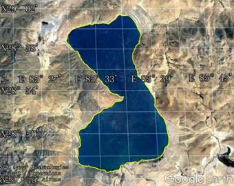
Figure 2 Map of
Paiku Co (.kmz format)
|
The vegetation around Paiku Co is dominated by alpine
grasslands. Among them, Alpine Stipa purpurea is the most widely distributed,
and there are various grassland types composed mainly of Artemisia, orinus
thoroldii, and pennisetum flaccidum. The
sediments around the lake basin are fine, the soil moisture conditions are
good, and the Achnatherum longearistata grassland is developed in some areas[7].
The water in Paiku Co Lake mainly depends on precipitation
and glacial-snowmelt runoff. There are 13
rivers of different sizes entering the lake around the lake and
glacial-snowmelt water is the main supply water of the river into the lake.
Barixiongqu is the largest runoff into the lake on the southeast shore,
followed by Zhaqu (Daqu) and Laqu on the south shore. The other rivers entering
the lake are smaller in scale, mostly seasonal. There are still more than 10
springs exposed in the basin, which are supplied to the lake. The lake has pH
of 9.5 and salinity of about 1.921 g·L–1, which is a carbonate
lake. There are naked carps in the lake, which are small and medium-sized
economic fish. There are county-level highways on the south, north and west
sides of the lake, which are connected to 219 National Road and 318 National
Road respectively[2]. There are
wild horses, kiangs, Tibetan antelopes, Tibetan cranes, ruddy shelducks, grey
teals and other animal activities on the lake shore,
and migratory birds inhabit.
The dataset was developed based on
Google Earth satellite images (2015) and related maps. The dataset is archived
in .shp[8] and .kmz formats, and
consists of 14 data files with a data size of 223 KB (compressed into 2 files
with 98.7 KB).
References
[1]
Institute
of Geographical Names, State Bureau of Surveying and Mapping. Tibetan Place
Names [M]. Beijing: China Tibetology Press, 1995.
[2]
Editorial
Committee of Encyclopedia Rivers and Lakes in China. Encyclopedia Rivers and
Lakes in China: Section of River Basins in Southwest Region [M]. Beijing: China
Water & Power Press, 2014.
[3]
Zhao, W.
L., Chen, Q., Liu, F. G. Paiku Co [J/DB/OL]. Digital Journal
of Global Change Data Repository, 2020. DOI: 10.3974/geodb.2020.03.23.V1.
[4]
Wang, S. M.,
Dou, H. S. Records of Lakes in China [M]. Beijing: Science Press, 1998.
[5]
W??nnemann,
B., Yan, D., Ci, R. Morphodynamics and lake level variations at Paiku Co,
southern Tibetan Plateau, China [J]. Geomorphology,
2015, 246: 489-501.
[6]
Climate
Center of Tibet Meteorological Administration. Tibet climate change monitoring
bulletin [R]. 2013.
[7]
Huang, F.
Tibet Paiku Co 13000-5000aB.P. Vegetation and environment [J]. Acta Palaeontologica Sinica, 2000(3):
441-448.
Data Computing
Environment
[8]
ESRI??s computing platform in the ArcGIS of Qinghai Normal University.
URL for Data
Downloading
http://geodoi.ac.cn/WebEn/doi.aspx?Id=1490.
Or search through: http://www.geodoi.ac.cn.