Erosion-deposition Dataset of Gan River Region in Northeast China
Yu, Y. F.1 Chen, S. B.1* Xiang, T. T.2 Zhou, H.1 Cheng, X.1
1.College of GeoExploration Science and Technology, Jilin University, Changchun 130026, China; 2.Changchun School of Architecture, Changchun 130607, China
Abstract: The terrain in China is often referred to as having three ladders, with the Greater Khingan Mountain range being the northeastern boundary between the second and third ladders. Boundaries between the three ladder areas, however, are solely based on qualitative descriptions; no precise boundaries have been previously defined. In order to quantitatively identify the boundary between the second and third ladders, erosion and sedimentary processes of the Gan River basin were analyzed using the Water Erosion Prediction Project (WEPP) which established four databases (slope, climate, soil and crop management). In this study, the slope database was established using hydrological analysis methods based on ASTER GDEM data; the climate database was established using daily precipitation, daily maximum temperature and daily minimum temperature; the crop management database was established using land use and classification data; and the soil database was established using physical and chemical properties. The databases for the Gan River basin were analyzed using WEPP model, results providing erosion and deposition information for the Gan River basin in northeastern China. The relationship between erosion volume, sedimentation volume and topographic factors (slope angle and length) were used to obtain the erosion and sedimentation balance of the Gan River basin, and to quantitatively extract the second and third ladder; the quantitative boundary was identified using erosion - deposit balance points (slope) that were determined via Ero-DepoData. These results coincide with the traditional qualitative boundary based on elevation and slope in this area. This study provides a new method for quantitatively extracting the second and third level ladder boundary.
Keywords: Gan River region; erosion-deposition; WEPP model; banlance point
1 Introduction
Topography in China has been referred to as having a ladder-like distribution, with the “Three Gradient Terrain” term being widely used. Traditional divisions for the three steps are qualitatively based; no quantitative divisions have been identified. In this study, we investigated the northeastern boundary between the second and third steps, traditionally delineated by the Greater Khingan Mountains. By using the Water Erosion Prediction Project (WEPP) model[1], the Erosion-Deposition process of the Gan River based on the Ero-DepoData_GanRiver_NE_China dataset is used to quantitatively identify the partial boundary for the second-third step.
2 Metadata of Dataset
The metadata of Ero-DepoData_GanRiver_NE_China dataset[2] is summarized in Table 1, which included the information about the dataset full name, short name, author, geographical region, temporal and spatial resolution, data publisher, and data sharing policy.
Table 1 Metadata of Ero-Depo_GanRiver_NE_China dataset
|
Items
|
Description
|
|
Dataset full name
|
Erosion-deposition dataset in facets of Gan River watershed in Northeast China
|
|
Dataset short name
|
Ero-DepoData_GanRiver_NE_China
|
|
Authors
|
Yu, Y. F. L-5386-2016, College of GeoExploration Science and Technology, Jilin University, yuyaf2011@163.com
Chen, S. B. L-5789-2016, College of GeoExploration Science and Technology, Jilin University, chensb@jlu.edu.cn
Xiang, T. T. L-5672-2016, Changchun School of Architecture, xiangtiantian1029@163.com
Zhou, H. L-4968-2016, College of GeoExploration Science and Technology, Jilin University, bb625218858@163.com
Cheng, X. L-4911-2016, College of GeoExploration Science and Technology, Jilin University, honeyxue0107@126.com
|
|
Geographical region
|
122°8′E-125°8′E, 49°10′N-51°30′N
|
|
Time
|
1982/1/1-2011/12/31
|
|
Spatial resolution
|
30 m
|
|
Data format
|
.rar, .kmz
|
|
Data Size
|
7,258.46 KB
|
|
Dataset and data files
|
The Ero-DepoData_GanRiver_NE_China consists of two files:
1. Ero-DepoData_GanRiver_NE_China.rar, raster and vector data, 5911.26 KB
2. GanRiver.kmz, the GanRiver doundary data, 1,347.20 KB
|
|
Foundation
|
National Natural Science Foundation of China (78659, 12784); Chinese Academy of Sciences (A75123)
|
|
Data publisher
|
Global Change Research Data Publishing and Repository, http://www.geodoi.ac.cn.
|
|
Address
|
No. 11A, Datun Road, Chaoyang District, Beijing 100101, China.
|
|
Data sharing policy
|
Data from the Global Change Research Data Publishing & Repository includes metadata, datasets (data products), and publications (in this case, in the Journal of Global Change Data & Discovery). Data sharing policy includes: (1) Data are openly available and can be free downloaded via the Internet; (2) End users are encouraged to use Data subject to citation; (3) Users, who are by definition also value-added service providers, are welcome to redistribute Data subject to written permission from the GCdataPR Editorial Office and the issuance of a Data redistribution license; and (4) If Data are used to compile new datasets, the ‘ten per cent principal’ should be followed such that Data records utilized should not surpass 10% of the new dataset contents, while sources should be clearly noted in suitable places in the new dataset[3]
|
3 Methods
The Ero-DepoData_GanRiver_NE_China dataset was created using the WEPP model; this dataset was a physical description of rill erosion, interrill erosion and sediment motion mechanisms in this area. By using the WEPP model, soil erosion, sediment yield and sediment discharge in different areas can be predicted[4]. The process undertaken to obtain this dataset was shown in Figure 1.
The process used to generate this dataset was: (1). Climate data from the China Meteorological Data Sharing Service System[5] was used to model the meteorological station in the Gan River using CLIGEN Generated in the WEPP model; (2). The soil database was obtained using six soil parameters[6]; (3). The crop management database was established using GlobCover2009 data. Data from this package was layered to extract different types of ecological regions with hierarchical classification. The Land Cover Classification System (LSCC) was then applied to divide the land surface into 22 land cover types[7–9]; (4). Slope data was obtained using ASTER GDEM data which was divided into several single slopes (Figure 2). After calculating the mean slope and slope length, the slope database was obtained using the WEPP model.
|
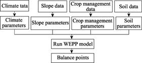
Figure 1 The flowchart of data processing
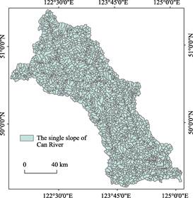
Figure 2 The single slope of Gan River basin
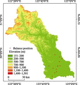
Figure 3 The balance position and elevation classification
|
By using four databases, the 2,960 relatively uniform slope of Erosion-
Deposition under different slope and different slope length in Gan River basin were obtained using the WEPP model. The Erosion-Deposition balance point was determined by the equal amount point of soil erosion and deposition.
4 Datasets Results and Verification
Landforms of the Northeast Plain and in the Greater Khingan Mountains region were analyzed based on previous studies using ASTER GDEM data with a spatial resolution of 30 m. Data from this analysis enabled elevation and slope in these regions to be reclassified, resulting in the reclassification maps of the Gan River basin. Then these maps were used to qualitatively extract the geomorphic boundary of the Northeast plain in the Greater Khingan Mountains region.
Accurate geographic location information of the erosion-sedimentation equilibrium point was obtained by extracting the erosion-sedimentation slope surface unit. The erosion-sediment balance point was combined with the elevation and slope reclassification maps of the Gan River basin to verify whether the quantitatively extracted boundary had similar characteristics to the traditional qualitative boundary (Figure 3 and Figure 4).
Figures 3 and 4 show that the erosion- edimentation equilibrium of the Gan River basin is in the transitional zone between the Greater Khingan Mountains and the Northeast Plain, and it is basically consistent with the qualitative extraction of the east side of Greater Khingan Mountains and the Northeast Plains. Our results therefore provide a reference for quantitative extraction of the boundary between the second and third steps in China.
|
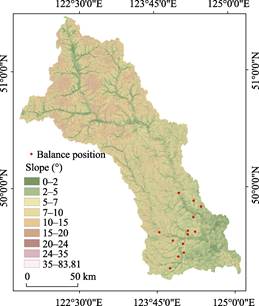
Figure 4 The balance position and slope classification
|
5 Discussion and Conclusion
Based on analysis of climate, soil, slope and crop management datasets in the Gan River basin, basic data and reference data were analyzed to map the erosion-sedimentation process of the eastern slope of the Greater Khingan Mountains. Results show that this quantitative analysis can identify the dividing line between the Greater Khingan Mountains and the Northeast Plain.
Author Contributions
Chen, S. B. proposed the idea of using basin erosion-sedimentation balance indicators as the dividing line of Northeast China’s academic thought, Xiang, T. T. was responsible for the design and research datasets. Yu, Y. F. wrote this paper. Data processing and analysis was undertaken by Yu, Y. F., Chen, S. B., Xiang, T. T., Zhou, H. and Cheng, X.. Yu, Y. F. validated analysis undertaken for this study and composed this manuscript.
Acknowledgements
We thank the China Meteorological Data Sharing Service System and ASTER GDEM data for providing research data. We would also like to thank Dr. Liu, C. and Dr. Shi, R. X. for their support for this paper.
References
[1] Zhang, Y. B., Zheng, F. L., Jia, Y. Y. WEPP model and its application [J]. Research of Soil and Water
Conservation, 2004,11(4): 146-149.
[2] Yu, Y. F., Chen, S. B., Xiang, T. T., et al. Erosion-deposition dataset in facets of Gan River watershed in Northeast China [DB/OL]. Global Change Research Data Publishing & Repository, 2015. DOI: 10.3974/ geodb.2015.01.07.V1.
[3] GCdataPR Editorial Office. GCdataPR Data Sharing Policy [OL]. DOI: 10.3974/dp.policy.2014.05 (Updated 2017).
[4] Xiao, P. Q., Yao, W. Y. Erosion theoretical basis of WEPP model [J]. Yellow River, 2005, 27(6): 38-50.
[5] China Meteorological Data Sharing Service System. http://cdc.cma.gov.cn/home.do.
[6] Ma, L., Zuo, C. Q. Major factors affecting erosion and runoff on red soil slope based on WEPP model [J]. Bulletin of Soil and Water Conservation, 2012, 32(6): 26-33.
[7] Niu, Z. G., Shan, Y. X., Zhang, H. Y. Accuracy assessment of wetland categories from the GlobCover2009 data over China [J]. Wetland Science, 2012, 10(4): 389-395.
[8] Xiang, T. T. Studying on process of erosion-deposition on eastern slope of Greater Khingan and its indicative significance [D]. Changchun: Jilin University, 2014.
[9] Kong, Y. P., Zhang, K. L., Cao, L. Appraise slope length factors in soil erosion study [J]. Research of Soil and Water Conservation, 2008, 15(4): 43-47.