Global Change Data Encyclopedia
Pentland Skerries, United Kingdom
Liu, C.* Shi, R. X.
Institute of Geographic Sciences and Natural Resources Research, Chinese Academy of Sciences, Beijing 100101, China;
Keywords: Pentland Skerries; Atlantic Ocean; Scotland; Muckle Skerry; data encyclopedia
|
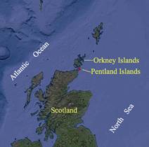
Figure 1 Geo-location of Pentland Skerries (Google Earth Image)
|
Pentland Skerries[1–2], the islands of Scotland, is located at 4.5 km to the Orkney Islands[3–4] in the southeast, 7.5 km to the mainland of Scotland in the northeast in the Pentland Firth[5] in the Atlantic Ocean. Its geo-location is 58°40′22″N-58°41′30″N, 2°56′5″W-2°53′17″W (Figure 1)[1].
The Pentland Skerries consist of four islands or skerries and three rocks (the smallest rock is 135 m2)[4]. The major islands include Muckle Skerry, Louther Skerry, Clettack Skerry and Little Skerry (Figure 2). The area, coastline and geo-location of the main islands in the Pentland Skerries are shown in Table 1.
The total area of the Pentland Skerries is 0.55 km2, the coastline of the Skerries is 7.78 km. The biggest island of the Pentland Skerries is the Muckle Skerry, with the area of 0.50 km2, the coastline of 5.03 km, and elevation of 0-20 m. The Pentland Skerries is uninhabited. The light towers (Figure 3), including the north high tower and the south low tower, were built on the Muckle Skerry in 1794[6]. The geo-location of the high tower is 58°41′24.48²N, 2°55′29.04²W and it is 36 m high.
The dataset was developed based on ArcGIS[7], the Google Earth images and the referenced maps. The dataset is archived in .kmz and .shp data formats, consisting of 14 data files with data size of 119 KB (Compressed to two files, 47.3 KB).
Table 1 List of main islands in the Pentland Skerries
|
Name of island
|
Geo-location
|
Center location
|
Area (m2)
|
Coastline (m)
|
|
Muckle Skerry
|
58°41¢9²N-58°41¢30²N??
2°56¢5²W-2°54¢51²W
|
58º41′19″N,
2º55′29″W
|
497,736
|
5,032
|
|
Little Skerry
|
58°40¢22²N-58°40¢30²N??
2°54¢55²W-2°54¢31²W
|
58º40′27″N,
2º54′41″W
|
38,442
|
1,240
|
|
Louther Skerry
|
58°40¢43²N-58°40¢48²N??
2°54¢4²W-2°53¢54²W
|
58º40′46″N,
2º53′57″W
|
5,976
|
554
|
|
Clettack Skerry
|
58°40¢56²N-58°40¢59²N??
2°53¢24²W-2°53¢17²W
|
58º40′58″N,
2º53′19″W
|
4,903
|
419
|
|
Others
|
|
|
4452
|
534
|
|
Pentland Skerries
|
58°40¢22²N-58°41¢30²N??
2°56¢5²W-2°53¢17²W
|
|
551,509
|
7,779
|
|
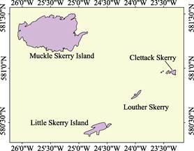
Figure 2 Geo-location of Pentland Skerries (.shp format)
|
|
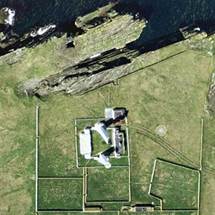
Figure 3 The lighthouses on Muckle Skerry (Google Earth image)
|
References
[1] Liu, C., Shi, R. X. Pentland Skerries [DB/OL]. Global Change Research Data Publishing & Repository, 2017. DOI: 10.3974/geodb.2017.01.12.V1.
[2] Pentland Skerries [OL]. https://en.wikipedia.org/wiki/Pentland_Skerries.
[3] Field Enterprises Educational Corporation. The World Book Encyclopedia (Volume 14) [M]. Chicago: Field Enterprises Educational Corporation, 1976: 648.
[4] Liu, C., Shi, R. X. Orkney Islands [DB/OL]. Global Change Research Data Publishing & Repository, 2017. DOI: 10.3974/geodb.2017.01.11.V1.
[5] Pentland Firth [OL]. https://en.wikipedia.org/wiki/Pentland_Firth.
[6] List of lighthouses in Scotland [OL]. https://en.wikipedia.org/wiki/List_of_lighthouses_in_Scotland.
Data Computing Environment
[7] ESRI. ArcGIS campus license of the Institute of Geographic Sciences and Natural Resources Research, Chinese Academy of Sciences.
URL for Data Downloading
http://www.geodoi.ac.cn/WebEn/doi.aspx?Id=651.
Or search: http://www.geodoi.ac.cn.