Dataset of Farmland Marginalization
Characteristics in Mountainous Areas of China
Li, S. F.1 Li, X. B.2*
1. Guangdong Open Laboratory of Geospatial Information Technology and Application, Guangzhou Institute of Geography, Guangzhou 510070, China;
2. Key Laboratory of Land Surface Pattern and Simulation, Institute of Geographic Sciences and Natural Resources Research, Chinese Academy of Sciences, Beijing 100101, China
Abstract: This study used the China Agricultural Production Costs and Returns Compilation (CAPCRC) to evaluate farmland marginalization characteristics under the context of rapidly rising agricultural labor prices, and provides a dataset of farmland marginalization characteristics in mountainous areas of China. The base compilation is an annual survey dataset of major agricultural production costs and earnings at the national level that was combined with the Chinaeco100-spatiotemporal distribution dataset of ecosystem types in China (1990-2010). Our results indicate that, since 2000, increasing agricultural opportunity cost and the constraint of rough terrains have increased the proportion of agricultural labor costs in mountainous areas of China. Furthermore, agricultural productivity in mountainous areas has increased slowly in comparison with the plain area, resulting in profits from agricultural production falling below zero in 2013. These obvious economic characteristics of farmland marginalization are in agreement with land use changes, including farmland reduction and forest expansion, in Chinese mountainous areas. The dataset includes geographic boundary data for the mountainous counties, economic characteristics data of farmland marginalization, and farmland and forest area changes in Chinese mountainous counties. An interpretation of the dataset is published in Acta Geographica Sinica, 2018, Volume 73, Issue 5.
Keywords: farmland marginalization; agricultural labor cost; agricultural labor productivity; agricultural production profit; Chinese mountainous areas
1 Introduction
Farmland marginalization refers to the decline of farmland profits or rentals for current types of land use. Since the 1950s, farmland marginalization and forest transformation have become the prevalent land use changes in mountainous and hilly areas worldwide, especially in developed regions and countries, such as Europe and Japan[1]. Current global farmland marginalization in mountainous areas is mainly caused by the continuous urbanization and industrialization and substantial reduction of agricultural laborers[2–4]. Since 2000, rapid urbanization and industrialization combined a shrinking agricultural labor force, the rapid increase in the opportunity cost of farming have significantly increased marginalized farmland in China. Accordingly, surveys of farmland abandonment show gradually increases[4], and a national survey also reported that the scale of idle land has a clear upward trend[5]. Previous research works have identified the factors influencing farmland abandonment at the parcel[6–7], household[8–9], and townships levels[10]. While zero profit is the fundamental cause of farmland abandonment[6], increases in the opportunity costs of agricultural production are also forcing farmers to abandon farmland[9], with urbanization and industrialization as the primary driving forces[11–12]. However, quantitative research on the characteristics of farmland marginalization in mountainous areas has not been conducted at the national level. Therefore, in this study, we used the CAPCRC and Chinaeco100-spatiotemporal distribution dataset of ecosystem types in China[13] to produce a dataset of farmland marginalization characteristics in Chinese mountainous areas. The dataset includes the characteristics of input-output and land use change and can provide data support for studying the mechanisms of farmland abandonment in mountainous areas.
2 Metadata of Dataset
The metadata for the dataset of farmland marginalization characteristics in mountainous areas of China[14] is summarized in Table 1, including the dataset full name, short name, authors, year, temporal resolution, spatial resolution, data format, data size, data files, data publisher, data sharing policy, etc.
3 Methods
3.1 Research and dataset development framework
With continuous urbanization, China reached the Lewis turning point around 2003. Thereafter, the rapid rise of non-agricultural wages led to an increase in the cost of agricultural opportunities, which in turn transmitted to agricultural labor prices, resulting in a decrease in net income from farmland cultivation. Because of the significant differences in natural conditions, adjusted farming practices vary between farmers in mountainous and plain areas. Such differences result into different labor costs, agricultural labor productivity, and net profit (rent), and subsequently to different changes in land-use types. Types of farmland marginalization include farmland abandonment and farmland to orchard and woodland; both favor revegetation and reforestation. Therefore, this dataset first analyzed the input and output changes of farmland cultivation in mountainous areas after the Lewis turning point by comparison with plain areas, which demonstrates the economic characteristics of farmland marginalization. Then, farmland and forest area of mountainous regions before and after the Lewis turning point were calculated to reveal the land-use change.
Table 1 Metadata summary for dataset of farmland marginalization characteristics in mountainous areas of China
|
Items
|
Description
|
|
Dataset full name
|
Dataset of farmland marginalization characteristics in mountainous areas of China
|
|
Dataset short name
|
FarmlandMarginalizationCharacteristicsMountainousArea
|
|
Authors
|
Li, S. F. S-9780-2018, Guangzhou Institute of Geography, li_shengfa@126.com
Li, X. B. O-1979-2016, Institute of Geographic Sciences and Natural Resources Research, Chinese Academy of Sciences, lixb@igsnrr.ac.cn
|
|
Geographical region
|
Chinese mountainous counties
|
|
Year
|
1990-2013
|
|
Temporal resolution
|
1 year, 5 years
|
|
Spatial resolution
|
Provincial level, 10 km
|
|
Data format
|
.dbf, .prj, .sbn, .sbx, .shp, .shx, .cpg, .kml
|
|
|
Data size
|
34.7 MB (4.72 MB after compression)
|
|
|
Data files
|
The dataset consists of 40 data files, archived in 1 compressed file package with 3 data folders. The contents under the data folder are:
1. Geographic boundary data of the mountainous counties, containing 8 data files that include the data of mountainous areas in China. Data size is 2.04 MB
2. Economic characteristics data of farmland marginalization, containing 3 data files, reflecting the economic characteristics of farmland marginalization in Chinese mountainous areas: (1) Proportion of agricultural labor costs in 2003 and 2013; (2) Changes in average labor productivity in maize cultivation; (3) Changes in profits of maize cultivation from 2004 to 2013. Data size is 32.9 KB
3. Land use changes in Chinese mountainous counties, containing 32 data files, reflecting the spatial changes in farmland and forest land in China’s mountainous counties from 1990 to 2000 and 2000–2010: (1) GIS data for farmland area changes from 1990 to 2000; (2) GIS data for farmland area changes from 2000 to 2010; (3) GIS data for forest area changes from 1990 to 2000; (4) GIS data for forest area changes from 2000 to 2010. Data size is 32.7 MB
|
|
Foundations
|
Ministry of Science and Technology of P. R. China (2015CB452706); National Natural Science Foundation of China (41801101, 41161140352); Guangdong Province (2018GDASCX-0903, 2017GDASCX-0101, 2018GDASCX-0101, 2018GDA SCX-0403)
|
|
Data publisher
|
Global Change Research Data Publishing & Repository, http://www.geodoi.ac.cn
|
|
Address
|
No. 11A, Datun Road, Chaoyang District, Beijing 100101, China
|
|
Data sharing policy
|
Data from the Global Change Research Data Publishing & Repository includes metadata, datasets (data products), and publications (in this case, in the Journal of Global Change Data & Discovery). Data sharing policy includes the following. (1) Data are openly available and can be freely downloaded via the Internet. (2) End users are encouraged to use Data subject to citation. (3) Users, who are by definition also value-added service providers, are welcome to redistribute Data subject to written permission from the GCdataPR Editorial Office and the issuance of a Data redistribution license. (4) If Data are used to compile new datasets, the ‘ten per cent principal’ should be followed such that Data records utilized should not surpass 10% of the new dataset contents, while sources should be clearly noted in suitable places in the new dataset[15]
|
3.2 Data Collection and Processing
3.2.1 Definition of Mountainous Areas
Owing to the ambiguities and uncertainties in defining mountainous areas[16], the main focus of this study was evaluating the differences in rural responses between households in rugged terrain and flat areas. Therefore, this study does not strictly define mountainous areas and plains. According to data accessibility, we used provincial data to analyze the economic characteristics of farmland marginalization, while the analysis of mountain land use change is based on statistics at the county level. Seven provinces and municipalities with the highest proportions of mountainous hilly area and highest proportions of slopping land were chosen to represent mountainous areas. To highlight the economic characteristics of farmland marginalization in mountainous regions, seven provinces with the highest percentages of plain area and highest proportion of flat farmland were selected to represent plains. According to the definition in the China County Statistical Yearbook, mountain counties refer to those with mountainous areas of more than 80%, of which there are about 900 counties.
3.2.2 Method for Economic Characteristics of Farmland Marginalization
The economic characteristics of farmland marginalization are mainly reflected in the changes in the proportion of labor cost, labor productivity, and in net profit per hectare. Because the study area spans several climatic zones, this paper uses the most widely distributed crop—maize in China as a proxy for comparing different input-output changes in farming between mountainous and plain provinces. The costs, benefits, and employment data for agricultural production were all obtained from the CAPCRC.
The proportion of labor cost refers to the per capita labor cost of maize, which accounts for the production cost excluding land cost. The equation is as follows:
 (1)
(1)
where Pl is proportion of labor cost per hectare, Cfl is household cost per hectare, Chl is employment costs per hectare, Cd is direct cost, and Ci is indirect cost, all cost is measured in yuan per hectare.
To compare agricultural labor productivity in different regions and different periods, this study uses the grain yield per unit of working days to measure agricultural labor productivity. The equation is as follows:
 (2)
(2)
where, E is agricultural labor productivity measured in kilogram per day, P is grain yield per hectare (kg/hectare), and L is labor use per hectare (d/hectare), including household and employment labor use.
The net profit per hectare refers to the net value. In this dataset, the net profit of all years was converted into the constant price in 2000 to eliminate the impact of inflation. The constant price conversion method is based on the constant GDP price published every five years in the China Statistical Yearbook. The equation is as follows:
 (Year: 2000-2005) (3)
 (Year: 2006-2010) (4)
 (Year: 2011-2015) (5)
where A is the constant price conversion coefficient in 2000, P2000, P2005, P2010 are the constant price of GDP in 2000, 2005, 2010 for a certain year. Pc is the current year price of GDP, is the 2000 constant price of 2005 GDP,
  is the 2005 constant price of 2005 GDP,
  is the 2005 constant price of 2010 GDP, and
  is the 2010 constant price of 2010 GDP.
3.2.3 Statistical Methods for Land Use Changes in Mountainous Areas
Farmland marginalization in mountainous areas is mainly the result of a reduction in cultivated land area and expansion of forest area. Therefore, our evaluation was based on the changes in farmland and forest land statistics within mountainous counties. To reduce the error from the remote sensing interpretation, and better reflect trends in land use change, we extracted land use changes in a 10×10 km grid when determining the spatial distribution of land marginalization in mountainous areas.
4 Results and Validation
4.1 Data Composition
The dataset consists of three folders: the geographic boundary data for the mountainous counties, economic characteristics data for farmland marginalization, and changes in farmland and forest area in Chinese mountainous counties.
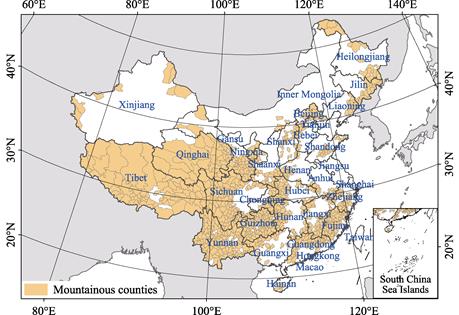
(1) The folder of geographic boundary data for the mountainous counties includes data for approximately 900 mountainous counties in .shp format (Figure 1). The boundary data are from the National Geomatics Center of China.
(2) The folder of economic characteristics of farmland marginalization data contains three data files in .xlsx format.
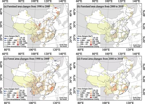
(3) The folder of land use changes in Chinese mountainous counties contains three data files in .shp format (Figure 2).
(Note: The base map data is from the National Geomatics Center of China.)
Figure 1 Distribution map of Chinese mountainous counties[17]
4.2 Data Products
The Distribution of the mountainous counties are based on the national counties’ boundary data at a scale of 1??1,000,000; therefore, the scale for this data is also 1??1,000,000. The three data tables for the economic characteristics data of farmland marginalization are annual and the spatial resolution is provincial. The land use change data’s spatial resolution is 10 km and the temporal resolution is 10 years.
(Note: The base map data is from the National Geomatics Center of China.)
Figure 2 Changes in farmland and forest in Chinese mountainous counties from 1990 to 2010
4.3 Data Validation
The CAPCRC is based on the annual survey conducted by the cost investigation team of marketing department at all levels, and the related departments for tobacco and supply. Household labor wages were calculated according to the national unified labor wages per day. Therefore, labor costs and net profits are not necessarily equivalent to the actual local value. A net profit below zero does not indicate an actual net deficiency of agricultural production in mountainous areas. However, the overall trend of rising agricultural production costs and declining profits in mountainous areas are accurate.
The land use data used in this paper were derived from the time series of land ecosystem classification dataset of China in five-year increments[13], which was based on interpreting Landsat TM (ETM+) data. Due to the rugged terrain of mountainous areas, dispersed and fragmented farmland can be difficult to identify from low- and medium-resolution remote sensing data, and hysteresis in representing remote sensing image often results in smaller areas of abandoned farmland than values obtained from household surveys.
5 Discussion and Conclusion
With China’s continued urbanization and industrialization, the exodus of agricultural labor, and rapid increase in the farming opportunity cost, the marginalization characteristics of cultivated land use in Chinese mountainous areas have become clearer since 2000. From the perspective of input-output characteristics, due to topographic conditions and the slow development of agricultural mechanization in mountainous areas, the labor input required for planting in mountainous areas is much larger than that in plain areas. Therefore, compared with plain areas, the proportional labor costs in mountainous provinces and municipality have risen significantly while productivity has increase more slowly, which in turn drove farming profits in mountainous areas to fall below zero in recent years. From the perspective of land use change from 1990 to 2000, Chinese mountainous counties were in a stage of farmland expansion due to massive reclamation. After 2000, reclamation activities in mountainous counties significantly weakened, and farmland area generally declined. Concurrently, changes in forest land showed an opposite trend. The transformation of land use in mountainous areas around 2000 was a response to farmland marginalization.
Author Contributions
Li, X. B. designed the algorithms for the dataset development; Li, S. F. contributed to the data processing and analysis, and wrote the data paper.
References
[1] Meyfroidt, P., Lambin, E. F. Global forest transition prospects for an end to deforestation [J]. The Annual Review of Environment and Resources, 2011, 36: 343-371.
[2] Rudel, T. K., Coomes, O. T., Emilio, M. F., et al. Forest transitions: towards a global understanding of land use change [J]. Global Environmental Change, 2005, 15(1): 23-31.
[3] Lambin, E. F., Meyfroid, P. Land use transitions: socio-ecological feedback versus socio-economic change [J]. Land Use Policy, 2010, 27(2): 108-118.
[4] Li, X. F., Li, X. B. Progress and prospect on farmland abandonment [J]. Acta Geographica Sinica, 2016, 71(3): 370-389.
[5] Gan, N., Yin, Z. C., Tan, J. J. China Household Finance Survey Report 2014 [M]. Chengdu: Southwestern University of Finance and Economics Press, 2015.
[6] Zhang, Y., Li, X. B., Song, W. Determinants of cropland abandonment at the parcel, household and village levels in mountain areas of China: a multi-level analysis [J]. Land Use Policy, 2014, 41: 186-192.
[7] Gellrich, M., Baur, P., Koch, B., et al. Agricultural land abandonment and natural forest re-growth in the Swiss mountains: a spatially explicit economic analysis [J]. Agriculture Ecosystems & Environment, 2007, 118(1-4): 93-108.
[8] Li, Z. H., Yan, J. Z., Hua, X. B., et al. Factors influencing the cultivated land abandonment of households of different types: a case study of 12 typical villages in Chongqing Municipality [J]. Geographical Research, 2014, 33(4): 721-734.
[9] Yan, J. Z., Yang, Z. Y., Li, Z. H., et al. Drivers of cropland abandonment in mountainous areas: a household decision model on farming scale in Southwest China [J]. Land Use Policy, 2016, 57: 459-469.
[10] Shi, T. C., Li, X. B., Xin, L. J., et al. The spatial distribution of farmland abandonment and its influential factors at the township level: a case study in the mountainous area of China [J]. Land use policy, 2018, 70: 510-520.
[11] Li, X. B., Zhao, Y. L. Forest transition, agricultural land marginalization and ecological restoration [J]. China Population, Resources and Environment, 2011, 21(10): 91-95.
[12] MacDonald, D., Crabtree, J. R., Wiesinger, G., et al. Agricultural abandonment in mountain areas of Europe: environmental consequences and policy response [J]. Journal of Environmental Management, 2000, 59(1): 47-69.
[13] Xu, X. L., Liu, J. Y., Zhang, Z. X., et al. A time series land ecosystem classification dataset of China in five-year increments (1990-2010) [DB/OL]. Global Change Research Data Publishing & Repository, 2015. DOI: 10.3974/geodb.2015.01.01.V1.
[14] Li, S. F., Li, X. B. Dataset of farmland marginalization characteristics in mountainous areas of China [DB/OL]. Global Change Research Data Publishing & Repository, 2018. DOI: 10.3974/geodb.2018.05. 20.V1.
[15] GCdataPR Editorial Office. GCdataPR data sharing policy [OL]. DOI: 10.3974/dp.policy.2014.05 (Updated 2017).
[16] Jiang, X. B., Zeng, H. C. Quantifying mountain regions of China: a case study in Sichuan [J]. Journal of Mountain Science, 2009, 27(1): 24-32.
[17] Li, S. F., Li, X. B. Economic characteristics and the mechanism of farmland marginalization in mountainous areas of China [J]. Acta Geographica Sinica, 2018, 73(5): 803-817.