Earth Data Encyclopedia
Boundary Data of the Lena River Basin
Huang, Y. F.1* Li, T. J.1 Zheng, Y. T.1 Lin, C. J.1 Xie, S.1 Liu, C.2 Shi, R. X.2
1. State key laboratory of hydroscience and engineering, Tsinghua University, Beijing 100084, China;
2. Institute of Geographic Sciences and Natural Resources Research, Chinese Academy of Sciences, Beijing 100101, China
Keywords: Lena River basin; boundary; Russia; data encyclopedia
|
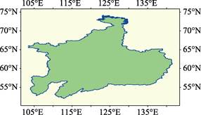
Figure 1 Geolocation of the Lena River Basin The dataset can be accessed at http://www.geodoi.ac.cn/WebEn/doi.aspx?Id=526.
|
The Lena River, one of the three biggest rivers in Siberlian, Russia (the other two are Ob River and Yenisei River), is originated at the Baikal Mountains (1,640 m) and flows north to the Lena River Delta and then the Laptev Sea of the Arctic Ocean. Several tributaries joined it, including the Kirenga, Vitim, Olyokma, Aldan and the Vilyuy Rivers.
The Boundary Data of the Lena River Basin covers the area from 103°23′59″E in west to 141°31′49″E in east and 51°59′22″N in south to 73°59′22″N in north (Figure 1). The total area of the river basin is 2,492,003.84 km2, the boundary of the basin is 25,499.86 km long.
All of the area of the basin, including the catchments of its tributaries is entirely within the Russian territorial boundaries. The river basin covers part areas of the Irkutsk Oblast, Respublika Buryatiya, Zabaykalsky Krai, Krasnoyarskiy Kray, Khabarovsk Krai and the Sakha (Yakutia) Republic.
The dataset was developed based on the ASTER-DEM in 30 m with the statistic models and validated by the Google Earth images in meter mostly. The dataset is archived in both .kmz and .shp data formats with the compressed data size of 13.6 MB.