1-km Resolution Dataset of Water Yield in the
National Ecological Barrier Zone (2000‒2015)
Yin, L. C.1, 2 Wang, X. F.3,4* Wang, Y.5
1. Key Laboratory of Land Surface
Pattern and Simulation, Institute of Geographic Sciences and Natural Resources Research, Chinese Academy of Sciences,
Beijing 100101, China;
2. University of Chinese Academy of Sciences, Beijing
100101, China;
3. The College of Land Engineering, Chang??an University,
Xi??an 710064, China;
4. The Key Laboratory of Shaanxi Land Consolidation Project,
Chang??an University, Xi??an 710064, China;
5. School of Earth Science and Resources, Chang??an
University, Xi??an 710054, China
Abstract: The relationship between
water and ecosystem is an important scientific issue that is widely concerned
by the society. As a
significant part of the national ecological security strategic pattern, water
yield service in the National Ecological Barrier Zone closely links the integrity
of China??s ecological system with the sustainable development of the society from the perspective of hydrology and water resources.
Meanwhile, its specialization and quantification are of great significance to
the management and optimal allocation of Chinese water resources. Aiming at the production of water yield dataset, based on
the principle of water balance, the modeling of barrier area water yield
service that is driven by remote sensing data is carried out. The basic data of water yield dataset of the National
Ecological Barrier Zone includes meteorology (Daily dataset of China surface
climate data (V3.0)), land use, NDVI and other data. The water yield module of
InVEST model is adopted. At the same time, the grid is applied as the unit to
realize the estimation of water yield service of national ecological barrier
area from 2000 to 2015. The spatial
resolution of the data is 1 km, and the time period is 2000-2015. The projection coordinate system is WGS_1984_Albers,
and the unit is mm. The data is archived in .tif format with a data size is 169
MB.
Keywords: National
Ecological Barrier Zone; water yield services; InVEST model
Dataset Availability Statement:
The dataset supporting this paper was published and is accessible
through the Digital
Journal of Global Change Data Repository at:
https://doi.org/10.3974/geodb.2020.03.18.V1.
1 Introduction
Ecosystem services are all kinds of benefits that human
beings get directly or indirectly from the ecosystem[1]. United
Nations Millennium Ecosystem Services Assessment (MEA) classifies them into
four categories, namely supply, regulation, support and cultural services[2]. Water yield service of an ecosystem is roughly
subordinate to regulation and supply services. Specifically, they represent the
phenomenon and process of water changes in terms of time, space and quantity
after water utilization and filtration by an ecosystem[3]. As an important regulation and supply service,
the water yield services of an ecosystem are the basis of various ecological
processes and ecological service functions[4]. Therefore, it plays
an important role in arresting precipitation, regulating runoff, purifying
water quality, improving hydrological conditions and regulating regional water
cycle[5]. Quantitative
evaluation of water yield services is the basis of rational utilization of
water resources and guarantee of regional sustainable development[6].
Therefore, current studies on water yield services have become a research
hotspot in the field of hydrology and watershed management[7-8].
The
developing purpose is aimed at building the time series products of water yield
services in the National Ecological Barrier Zone, carrying out researches on
the tradeoff and collaboration of ecosystem services in the barrier area, and
further consolidating and optimizing the regional ecological service function,
so as to ensure the national ecological security and sustainable development. The hydrological regulation capacity is measured
by deducting the maximum potential available surface water on the grid scale,
and the water yield services in the National Ecological Barrier Zone is
obtained by subtracting the precipitation from the evapotranspiration. The water yield module of InVEST model that is
based on the principle of water balance was adopted to calculate the water
yield dataset with 1-km spatial resolution for the National Ecological Barrier
Zone, and the results were directly expressed in the form of raster map.
2 Metadata of the Dataset
The
metadata summary of the dataset is shown in Table 1. It includes the dataset
full name, short name, authors, year of the dataset, temporal resolution,
spatial resolution, data format, data size, data files, data publisher, and
data sharing policy, etc[9].
3 Methods
3.1 Data Sources and
Preprocessing
(1)
Meteorological data is the daily dataset of China surface climatic data (V3.0),
and is from China Meteorological Data Network. ANUSPLIN[12] was
applied to interpolate national meteorological elements in batches, with a
spatial and temporal resolution of 1 km·d-1.
(2)
China??s land use data (2000, 2005, 2010 and 2015) are obtained from China??s
land use status remote sensing monitoring database, with a spatial resolution
of 1 km.
(3) NDVI data (2000-2015) is a MOD13A2 1 km vegetation index
composite product for 16 days, and is downloaded from the geospatial data
cloud. Through batch format conversion, annual maximum value synthesis, batch
cropping and projection conversion, the annual NDVI raster dataset with the
resolution of 1 km in the study area was obtained.
Table 1 Metadata summary of the ??Water yield
product 1km grid yearly dataset in National Barrier Zone of China (2000-2015)??
|
Items
|
Description
|
|
Dataset full name
|
Water yield product 1km grid
yearly dataset in National Barrier Zone of China (2000-2015)
|
|
Dataset short name
|
NBZ_water_1km_2000-2015
|
|
Authors
|
Yin, L. C., Key Laboratory of
Land Surface Pattern and Simulation, Institute of Geographic Sciences and
Natural Resources Research, Chinese Academy of Sciences,
yinlichang3064@163.com
Wang, X. F., School of Land
Engineering, Chang??an University; Shaanxi Key Laboratory of Land Engineering,
wangxf@chd.edu.cn
Wang, Y., School of Earth
Science and Resources, Chang??an University,
wangyichangan134@163.com
|
|
Geographical region
|
The area[10]
involves provinces: Heilongjiang, Jilin, Qinghai, Gansu, Sichuan, Xinjiang,
Inner Mongolia, Hebei, Liaoning, Xizang, Ningxia, Yunnan, Guangxi, Guangdong,
Guizhou, Hunan, Jiangxi, Shanxi
The northern sand belt (36??45??N-45??06??N, 75??50??E-124??18??E)
The ecological barrier of
Qinghai-Tibet Plateau (29??40??N-38??10??N, 82??50??E-105??5??E)
The ecological barrier of
Sichuan-Yunnan Loess Plateau (24??10??N-38??50??N,
99??05??E-114??25??E)
The south hilly mountain belt
(22??45??N-27??10??N, 103??10??E-119??15??E)
The northeast Forest belt (40??52??N-53??34??N, 118??48??E-134??22??E)
|
|
Year
|
2000-2015
|
|
Temporal resolution
|
1 year
|
|
Spatial resolution
|
1 km
|
|
Data format
|
.tif
|
|
Data size
|
169 MB (After compression)
|
|
Data files
|
There are 16 .tif data and the
naming rules are ??NBZ_water_?? + spatial resolution + year, such as ??NBz_water_1km_2000.tif??,
indicating that the 1-km resolution dataset of water yield in the National
Ecological Barrier Zone is in 2000, the years are in order from 2000 to 2015
|
|
The projection coordinate
|
WGS_1984_Albers
|
|
Foundations
|
Ministry of Science and
Technology of P. R. China (2019QZKK0405); Chinese Academy of Sciences
(XDA2002040201)
|
|
Data publisher
|
Global Change Scientific
Research Data Publishing System http://www.geodoi.ac.cn
|
|
Address
|
No. 11
A Datun Road, Chaoyang District, Beijing 100101, China
|
|
Data sharing policy
|
Data from the Global Change
Research Data Publishing &Repository includes metadata, datasets (in the Digital Journal of Global Change Data Repository), and
publications (in the Journal of Global Change Data & Discovery). Data
sharing policy includes: (1) Data are openly available
and can be free downloaded via the Internet; (2) End users are encouraged to
use Data subject to citation; (3) Users, who are by definition
also value-added service providers, are welcome to redistribute Data subject
to written permission from the GCdataPR Editorial Office and the issuance of
a Data redistribution license; and (4) If Data are
used to compile new datasets, the ??ten per cent principal?? should be followed
such that Data records utilized should not surpass 10% of the
new dataset contents, while sources should be clearly noted in suitable
places in the new dataset[11]
|
|
Communication
and searchable system
|
DOI, DCI, CSCD, WDS/ISC, GEOSS,
China GEOSS, Crossref
|
3.2 InVEST model
Based on the principle of
water balance, this dataset adopts the water yield module of InVEST model to
calculate the water yield of the National Ecological Barrier Zone from 2000 to
2015, so as to represent the regional water supply. By interpolating the input
precipitation and output evapotranspiration of regional water, and combining
climate, terrain, vegetation, soil and other factors as well[13],
the water yield capacity of different landscape components is quantitatively
evaluated based on grid units. The specific calculation formulas are as
follows:
 (1)
(1)
 (2)
(2)
 (3)
(3)
where WY(x) refers to the annual water volume
(mm) of a certain landscape type x in
the grid unit, AET(x) marks the annual actual evaporation
capacity (mm) of unit x, and P(x)
means the annual rainfall (mm) of unit x.
PET(x) stands for the potential evapotranspiration (mm) of unit x that is calculated by Penman equation[14].
AWC(x) represents the available water content of plants. W(x)
refers to an empirical parameter, and Z
is Zhang coefficient[15].
4 Data
Results and Validation
4.1
Data Composition
The water yield product 1-km grid yearly dataset in
National Barrier Zone of China (2000-2015) is the annual water dataset on the
National Ecological Barrier Zone from 2000 to 2015 in ArcGIS TIFF format. The
spatial resolution is 1 km, the unit is mm, and the projection coordinate
system is WGS_1984_Albers. After compression, the data size is 169 MB.
4.2
Data Results
The spatial distribution of water yield with a resolution
of 1 km in the National Ecological Barrier Zone from 2000 to 2015 is
illustrated in Figure 1. From 2000 to 2015, the average water yield in the study
area was 206.63 mm, generally suggesting a pattern of high in the southeast and
low in the northwest. The high values
were concentrated in the Ecological barrier of the Sichuan-Yunnan to Loess
Plateau and then to the southern hilly and mountainous belt, the middle values
were in the northeast forest belt and the southeast of the ecological barrier
of Qinghai-Tibet Plateau, and the low values were located in the northwest and
northern sand control belt of the ecological barrier of Qinghai-Tibet Plateau. Between 2000 and 2015, 86.3% of the regional
water yield services in the National Ecological Barrier Zone was increased, there
was a large increasing in the northwest of the northeast forest belt and the central
part of the hilly and mountainous belt in the south, while the areas with lower
water yield were concentrated in the southeast of Sichuan-Yunnan Plateau.
4.3 Data Validation
Verification
results at 30 stations revealed that the average water yield from 2000 to 2015
in this paper was highly correlated with the multi-year average water yield
that was calculated based on the comprehensive storage capacity method[16],
and the determination coefficient R2
reached 0.81, indicating that the water yield in this paper could better
represent the spatial distribution of water yield in the National Ecological
Barrier Zone.
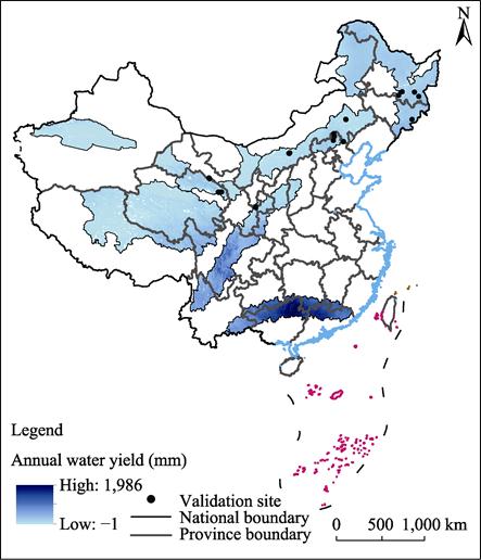
Figure 1 Map of the 1-km resolution
water yield in the National Ecological Barrier Area (2015)
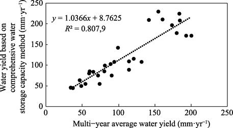
Figure 2 Comparative assessment of multi-year
average water yield.
(Note: All site data are observation
data)
5 Conclusion
In
order to construct the time series product of the National Ecological Barrier
Zone water yield service, the modeling research was carried out on the basis of
the InVEST model water yield module with remote sensing, meteorology, land use
and other data. The results showed
that the average water yield in the study area was 206.63 mm that was generally
high in the southeast and low in the northwest. Compared with the results calculated by the
integrated storage capacity method based on site observation data, the results
prove that the water yield in this paper can better represent the spatial
distribution of water yield in the National Ecological Barrier Zone.
The water yield dataset
with a spatial resolution of 1 km from 2000 to 2015 displays the temporal and
spatial distribution of water yield, and is an important input factor, so as to
reveal the spatial-temporal evolution of ecosystem services and tradeoffs in
the barrier area in recent years. It can provide reliable basic data and information for the
exploration of the ecosystem service function of the National Ecological
Barrier Zone under the background of global change, thus comprehensively and
deeply understanding and grasping the security situation of the National
Ecological Barrier Zone and providing the sustainable development of ecosystem.
References
[1]
Costanza,
R., d??Arge, R., de Groot, R., et al.
The value of the world??s ecosystem services and natural capital [J]. Nature,
1997, 387(6630): 253‒260.
[2]
Toth, F. L.
Ecosystems and Human Well-being: A Framework for Assessment [M]. Washington DC:
Island Press, 2005.
[3]
Lv, Y. H.,
Hu, J., Sun, F. X., et al. Water
retention and hydrological regulation: harmony but not the same in terrestrial
hydrological ecosystem services [J]. Acta
Ecologica Sinica, 2015, 35(15): 5191‒5196.
[4]
Guo, H. W.,
Sun, X. Y., Lian, L. Z., et al.
Response of water yield function of ecosystem to land use change in Nansi Lake
Basin based on CLUE-S model and InVEST model [J]. Chinese Journal of Applied Ecology, 2016, 27(9): 2899‒2906.
[5]
Tallis, H.
T., Ricketts, T., Guerry, A. D., et al.
InVEST 2.5.3 user??s guide [Z]. Stanford: The Natural Capital Project, 2003??
[6]
Gu, Z. M.,
Jin, X. B., Shen, C. Z., et al.
Variation and influence factors of water conservation service function in
Jiangsu province from 2000 to 2015 [J]. Resources
and Environment in the Yangtze Basin, 2018, 27(11): 2453‒2462.
[7]
Terrado,
M., Acuña, V., Ennaanay, D., et al.
Impact of climate extremes on hydrological ecosystem services in a heavily
humanized Mediterranean basin [J]. Ecological
indicators, 2014, 37: 199‒209.
[8]
Brauman, K.
A., Daily, G. C., Duarte, T. K., et al.
The nature and value of ecosystem services: an overview highlighting hydrologic
services [J]. Annual Review of Environment and Resources, 2007, 32:
67‒98.
[9]
Yin, L. C.,
Wang, X. F., Wang, Y. The 1-km resolution dataset of water yield in the
National Ecological Barrier Zone (2000-2015) [J/DB/OL]. Digital Journal of Global change data repository, 2020. https://doi.org/10.3974/geodb.2020.03.18.V1.
[10]
Yin, L. C.,
Wang, X. F., Zhang, K., et al.
Trade-offs and synergy between ecosystem services in National Barrier Zone [J].
Geographical Research, 2019, 38(9):
2162‒2172.
[11] GCdataPR Editorial Office. GCdataPR data sharing
policy [OL]. https://doi.org/10.3974/dp.policy.2014.05 (Updated 2017).
[12]
Hijmans, R.
J., Cameron, S. E., Parra, J. L., et al.
Very high resolution interpolated climate surfaces for global land areas [J].
International Journal of Climatology, 2005, 25(2): 1965‒1978.
[13]
Qian, C. Y.,
Gong, J., Zhang, J. X., et al. Change
and tradeoffs-synergies analysis on watershed ecosystem services: a case study
of Bailongjiang watershed, Gansu [J]. Acta
Geographica Sinica, 2018, 73(5): 868‒879.
[14]
Allen, R. G.,
Pereira, L. S., Raes, D. Crop evapotranspiration—guidelines for computing crop
water requirements [Z]. FAO irrigation and drainage paper 56, FAO 1998.
[15]
Zhang, L.,
Hickel, K., Dawes, W. R., et al. A rational
function approach for estimating mean annual evapotranspiration [J]. Water
resources research, 2004, 40: 89‒97.
[16]
Wu, X., Shi,
W. J., Guo, B., et al. Large spatial
variations in the distributions of and factors affecting forest water retention
capacity in China [J]. Ecological
Indicator, 2020, 113: 106152.