Global Change Data Encyclopedia
Boundary Data of the Weihe River Basin, China
Huang, Y. F.1* Li, T. J.1 Lv, E. Z.1 Li, J. Y.1 Bai, R.1 Liu, C.2 Shi, R. X.2
1. State key laboratory of hydroscience and engineering??Tsinghua University??Beijing 100084??China;
2. Institute of Geographic Sciences and Natural Resources Research, Chinese Academy of Sciences, Beijing 100101, China
Keywords: Weihe River basin; boundary data; data encyclopedia
|
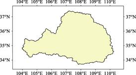
Figure 1 Weihe River basin (.shp format)
|
The Weihe River is the biggest branch of the Yellow River of China. The Weihe River basin covers partly the area of Shanxi, Gansu provinces and Ningxia Hui autonomous region. The boundary of the basin is from the Mt. Niaoshu (2,609 m) in the west, and goes to the southeast to the Mt. Maji (1,658 m) and Mt. Taibai (main peak of Qinling, 3,767 m), and then goes to the east to Mt. Zhongnan (2,604 m), Mt. Huashan (2,160 m), and to meet the Yellow River near the Tongguan town[1–2]. From the Mt. Niashu (2,609 m) to the northeast, it goes through the Longzhong Plateau, then Mt. Huajialing (2,450 m), Mt. Liupan (2,928 m), to Mt. Baiyushan (1,823 m), and then follows the Mt. Huanglong to meet the Yellow River[2–3]. The geolocation of the basin is from 103°58′18″E in the west to 110°16′28″E in the east, and from 33°41′47″N in the south to 37°24′30″N in the north. The total area of the basin is 134,731.12 km2, and the boundary line is 2,768.24 km[4]. The most historical heritages, such as the Xi’an city, one of the oldest capitals of China, are located in the basin[5].
Weihe River basin belongs to Shaanxi province, Gansu province and Ningxia Hui Autonomous region (Table 1)[6]. Regarding the area, about half of the Weihe River basin (49.88%) belongs to Shaanxi province; followed by Gansu province (approximately 44.03%), and then Ningxia Hui autonomous region (6.09%).
The boundary data of the Weihe River basin was developed based on the ASTER-DEM[7] with the statistic models and validated by the Google Earth images. The data is archived in both .kmz and .shp[8] formats with the compressed data size of 8.47 MB.
Table 1 Administrative regions of Weihe River basin
|
Province
|
Prefecture-level city
|
County (county-level city and autonomous county)
|
Area (km2)
|
|
Shaanxi
|
Xi’an, Tongchuan, Baoji, Xianyang; parts of Weinan, Yanan, Hanzhong, Yulin, Ankang, and Shangluo (full areas of four cities and parts of six cities)
|
Lantian, Zhouzhi, Huxian, Gaoling, Yijun, Fengxiang, Qishan, Fufeng, Meixian, Longxian, Qianyang, Linyou, Fengxian, Taibai, Sanyuan, Jingyang, Qianxian, Liquan, Yongshou, Binxian, Changwu, Xunyi, Chunhua, Wugong, Xingping, Huaxian, Tongguan, Dali, Heyang, Chengcheng, Pucheng, Baishui, Fuping, Huayin, Ansai, Zhidan, Wuqi, Ganquan, Fuxian, Luochuan, Yichuan, Huanglong, Huangling, Foping, Jingbian, Dingbian, Ningxian, Luonan, Zhashui (total in 49 counties and county-level cities)
|
67,203.72
|
|
Gansu
|
Tianshui, Pingliang, Qingyang, Dingxi; parts of Longnan and Gannan Tibetan autonomous prefecture (full areas of four cities and parts of two cities)
|
Qingshui, Qinan, Gangu, Wushan, Zhangjiachuan Hui autonomous county, Jingchuan, Lingtai, Chongxin, Huating, Zhuanglang, Jingning, Qingcheng, Huanxian, Huachi, Heshui, Zhengning, Ningxian, Zhenyuan, Tongwei, Longxi, Weiyuan, Lintao, Zhangxian, Minxian, Dangchang, Lixian, Zhuoni (total in 27 counties and autonomous counties)
|
59,325.09
|
|
Ningxia
|
Guyuan; parts of Wuzhong and Zhongwei (full area of one city and parts of two cities)
|
Xiji, Longde, Jingyuan, Pengyang, Yanchi, Tongxin, Haiyuan (total in 7 counties)
|
8,202.30
|
|
Total
|
full areas of nine cities and parts of ten cities
|
83 counties (county-level cities and autonomous counties)
|
134,731.12
|
References
[1] Song, J. X., Li, H. E. Water demand for Weihe ecological environment [M]. Beijing: China Water & Power Press, 2004.
[2] Li, J. Y., Shi, C. W., Yan, R., et al. Integrated Management of Resources and Environment in Weihe River Basin, Shaanxi Province [M]. Xi’an: Xi’an Map Press, 2006: 5-6.
[3] SinoMaps Press. Atlas of Physical Geography of China (2nd Edition) [M]. Beijing: SinoMaps Press, 1998.
[4] Huang, Y. F., Li, T. J., Lv, E. Z., et al. Boundary data of the Weihe River basin, China [DB/OL]. Global Change Research Data Publishing & Repository, 2016. DOI: 10.3974/geodb.2016.03.07.V1.
[5] Fang, G. H. A millennium review of the Mausoleum of the Yellow Emperor [J]. Chinese Culture, 2016(2): 8-9.
[6] Ministry of Civil Affairs of P. R. China. A Brochure of Administrative Divisions of P. R. China (2015) [M]. Beijing: China Water & Power Press, 2015.
[7] ASTER GDEM 2. Advanced Spaceborne Thermal Emission and Reflection Radiometer (ASTER), October 2011, Digital Elevation Database, Earth Remote Sensing Data Analysis Center, Japan, ASTER GDS User Service, http://www.gds.aster.ersdac.or.jp/gds_www2002/service_e/inq.c_e/set_inq.c_e.html, LP DAAC User Services, https://lpdaac.usgs.gov/customer_service.
Data Computing Environment
[8] ESRI. ArcGIS campus license of Institute of Geographic Sciences and Natural Resources Research, Chinese Academy of Sciences.
URL for Data Downloading
http://www.geodoi.ac.cn/WebEn/doi.aspx?Id=424.
Or search through: http://www.geodoi.ac.cn.