Global Change Data Encyclopedia
Pulau Bangka, Indonesia
Wang, J. Q.1
Yang, A. B1 Zhang,
F.1*
Liu, C.2 Shi, R. X.2
1. School of Earth Sciences, Zhejiang University, Hangzhou
310000, China;
2. Institute of Geographic Sciences and Natural Resources
Research??Chinese Academy of Sciences, Beijing 100101, China
Keywords: Pulau Bangka; Indonesia;
island; data encyclopedia
Pulau Bangka is located in the west of the Greater Sunda Islands in
Southeast Asia, bordering the Java Sea in the south and Sumatra Island in the
west. The closest distance between the two islands is 14 km. The closest
distance between the two islands is about 85 km. The geographical location of
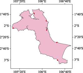
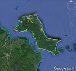
Bangka island is 1??30¢5²S?C3??7¢0²S, 105??6¢31²E?C106??50¢ 56²E[1?C2] (Figure 1, 2). Bangka
Island covers an area of 11,528.23 km2 and has a coastline of
1,164.91 km.
|
|
|
|
Figure 1 Map of Pulau Bangka (.shp format)
|
Figure 2 Map of Pulau Bangka (.kmz format)
|
Bangka Penang is the capital and largest town of Bangka Island. The
second-largest city is Shuang Khyria (Lek), and the main port of Bangka Island
(Mentok). Other towns include Toboali in the south, Koba (an important
tin-mining town in the south of Banga), and Beli Ocean in the north (known for
its local seafood)[3].
The Bangka Island had a population of
626,955 in 1990 and is populated mainly by ethnic Malay Indonesians and Han Hakka
people. Residents mainly work in tin mines, oil palm farms, rubber plantations,
and pepper farms, and some are engaged in tin smelting and fishing. In 2010,
the population rose to 960,692[3].
The whole island is mostly remnant hill
lowland. There are a few 300?C600 m high mountain tops, and the seaside is many
swamps. Bangka Island is a tropical rainforest climate, hot and humid
throughout the year, annual rainfall of about
3,000 mm. Geologically, Bangka Island is similar to the Malay Peninsula, which
is composed of granite and slate. Generally, it is covered by sandstone,
laterite, and alluvium, and granite outcrops form small scattered hills[4].
Meanwhile, from 1710 to the present, Bangka is one of the world??s major tin
producing areas[5].
This dataset was
based on the ??Global multiple-scale shorelines dataset based
on Google Earth images (2015)??[2], which is integrated with the relevant material and map of
Bangka Island[5‒8]. The dataset consisted of 21 data files, archived in .kmz and .shp[9]
formats, with a data volume of 1.02 MB (compressed into 3 data files, with a
data size of 716 KB).
References
[1]
Wang J. Q., Yang, A. B., Zhang F., et al. Pulau Bangka [DB/OL]. Global Change
Data Repository, 2020. DOI: 10.3974/geodb.2020.02.11.V1.
[2]
Liu, C., Shi, R. X., Zhang, Y. H., et al. Global multiple-scale shorelines
dataset based on Google Earth images (2015) [DB/OL]. Global Change Data
Repository, 2019. DOI: 10.3974/geodb.2019.04.13.V1.
[3]
Bangka [OL]. Wikipedia. https://en.m.wikipedia.org/wiki/Banga.
[4]
Bangka [OL]. Encyclopedia Britannica. https://www.britannica.com/place/Bangka.
[5]
Laclay, S. History of Indonesia
[M]. Translated by Guo, Z. L. Beijing: Commercial Press, 2009.
[6]
The Editorial Office of ??Travel Around the World?? in Japan.
Indonesia [M]. Beijing: China Tourism Press, 2020.
[7]
China Map Publishing House. Indonesia [M]. Beijing: China Map
Publishing House, 2018.
[8]
Xu, L. P. Indonesia [M]. Beijing: Social Sciences Literature
Press, 2018.
Data Computing Environment
[9]
ESRI.
ArcGIS campus license of Zhejiang University.
URL for Data Downloading
http://www.geodoi.ac.cn/WebEn/doi.aspx?Id=1434.
Or search
through: http://www.geodoi.ac.cn.