Development of a Spatial-temporal Distribution Dataset of
the Tidal Creek Morphological
Characteristics in the Yellow River Delta (1998–2018)
Mou, K. N.1, 2 Gong, Z. N.1,2* Qiu, H. C.1, 2
1. College of Resource Environment and Tourism, Capital
Normal University, Beijing 100048, China;
2. MCA Key Laboratory of Disaster Assessment and Risk
Prevention, Capital Normal University, Beijing 100048, China
Abstract: A tidal creek is the main channel of interaction between the
land and sea ecosystems, and it is highly spatiotemporally dynamic. The spatial-temporal
distributions of tidal creeks have obvious spatial-temporal heterogeneity. The
results of this study have important theoretical significance and scientific
value for rationally constructing coastal engineering facilities and protecting
tidal flat resources. Based on Landsat thematic mapper/operational land imager
(TM/ OLI) satellite data for 20 scenes from 1998 to 2018 (cloud cover <10%),
we extracted tidal creeks using an accurate algorithm for tidal creek network
extraction under a heterogeneous background and classified the tidal creeks
using the fast automatic classification algorithm. After classifying the tidal
creeks, the geographic information system (GIS) spatial analysis function was
used. A temporal and spatial distribution dataset of the tidal creek
morphological characteristics from 1998 to 2018 was generated by extracting the
morphological parameters of the tidal creeks in the study area during the last
5 years. The dataset includes the following data for the Yellow River Delta for
1998, 2004, 2008, 2013, and 2018: (1) the distribution of the tidal creeks; (2)
the maximum distribution range of the tidal flat; (3) the kernel density
distribution of the tidal creek density; (4) the kernel density distribution of
the bifurcation ratio of the tidal creeks; and (5) the non-channel path length
distribution. The spatial resolution of the raster data is 30 m. The dataset is
archived in .shp and .tif formats, and the projection coordinate system is WGS_1984_UTM_Zone_50N.
It contains 120 data files, and the data size is 81.4 MB (14.8 MB is compressed
into one file).
Keywords: tidal creek network; morphological
characteristic parameter; Yellow River Delta; long time series
DOI: https://doi.org/10.3974/geodp.2022.02.09
CSTR: https://cstr.escience.org.cn/CSTR:20146.14.2022.02.09
Dataset Availability Statement:
The
dataset supporting this paper was published and is accessible through the Digital Journal of Global Change Data Repository
at: https://doi.org/10.3974/geodb.2022.01.09.V1
or https://cstr.escience.org.cn/CSTR:20146.11.2022.01.09.V1.
1 Introduction
As
a typical geomorphic unit of a tidal flat, a tidal creek is a tidal channel
developed in the intertidal zone and formed by marine dynamics. Since the tidal
flat is an important channel for material, energy, and information exchange
with the outside world, the tidal creek, which depends on the distribution of
the tide and sediment supply, plays an important role, is the main driving
force in shaping the terrain of the tidal flat, and is an important driving
force of the spatial distribution characteristics of the salt marsh vegetation,
which directly affects the changes in the coastal wetland ecological
environment.
Under the
comprehensive influence of natural and human activities, the morphological
characteristics of tidal creeks are complex and variable, with high spatial-temporal
heterogeneity. Since the diversion of the Yellow River in 1996, the large
number of coastal projects and the invasion of Spartina alterniflora in the study area have broken the original
balance and have seriously affected the habitat function of the tidal creeks,
which may eventually lead to the loss of salt marsh habitats and increase the
risk of flooding in this region. Therefore, studying the spatial-temporal
distributions of the tidal creek morphological characteristics in the Yellow
River Delta using a long-time series of data to further understand the
evolution of the morphological characteristics of the tidal creek system under
the influences of natural and human activities provides key information for
actively managing the development of tidal flat resources, invasive species
control, and coastal engineering protection. Owing to the limitations of the
complex underlying surface of the Yellow River Delta wetland and the frequent
morphological changes of the tidal creeks, the traditional field measurement
methods cannot be effectively applied. Therefore, compared with point-scale
field measurements, remote sensing technology has the advantages of a large
coverage, short revisit period, and low cost, and it can solve the problem of
the difficult characterization of the morphological characteristics of the
tidal creek network caused by the complex geographical environment and the
complex structure of the network in the coastal zone.
In this study, the
Yellow River Delta was taken as the research area. Through in-depth mining of
20 Landsat thematic mapper/operational land imager (TM/OLI) remote sensing
datasets, a spatial distribution dataset of the tidal creek morphological
characteristics from 1998 to 2018 was obtained.
2 Metadata of the Dataset
The
metadata of the Spatial-temporal dataset of tidal creek morphological
characteristics in Yellow River Delta (1998–2018)[1] are presented
in Table 1.
3 Methods
In
this study, 20 Landsat satellite datasets with good quality (cloud cover
<10%) from 1998 to 2018 were selected. Specifically, 12 landsat-5 TM images,
8 LANDsat-8 OLI images, 1 SPOT-6 image, and 1 GF-1 panchromatic and multispectral
(PMS) images were selected. The level-1 products of the Landsat series
satellite data were obtained from the United States Geological Survey Remote
Sensing Image database, and the Gaofen series satellite datawere obtained from the China
Resources Satellite Center. Radiometric calibration, atmospheric correction, and geometric
correction were conducted to preprocess the image. Using the Google Earth
Engine platform and background homogenization and linear feature enhancement, a
tidal creek automatic extraction algorithm was used to extract the tidal creeks
and obtain the complete tidal creek data after manual supplementation[3].
A fast automatic classification algorithm was used to classify the tidal creeks[4].
The maximum distribution range of the tidal flat in the study area was obtained
by stacking the tidal flat area exposed at high and low tides in the same year.
Table 1 Metadata summary of the Spatial-temporal
dataset of tidal creek morphological characteristics in Yellow River Delta (1998–2018)
|
Items
|
Description
|
|
Dataset full name
|
Spatial-temporal
dataset of tidal creek morphological characteristics in Yellow River Delta (1998–2018)
|
|
Dataset short name
|
TidalCreekYRD_1998–2018
|
|
Authors
|
Mou, K. N., College of Resource Environment and Tourism, Capital Normal
University, moukuinan@163.com
Gong, Z. N., College of Resource Environment and Tourism, Capital Normal
University, gongzhn@cnu.edu.cn
Qiu, H. C., College of Resource Environment and Tourism, Capital Normal
University, qiu_huachang@163.com
|
|
Geographical region
|
Estuarine wetlands at the mouth of the Yellow River Delta
|
|
Year
|
1998–2018
|
|
Temporal resolution
|
year
|
|
Spatial resolution
|
30 m
|
|
Data format
|
.tif, .shp
|
|
Data size
|
81.4 MB (Compress to a file,14.8 MB)
|
|
Data files
|
Tidal creek
distribution data, tidal flat maximum distribution range data, tidal creek
density kernel density distribution data, tidal creek branching point kernel
density distribution data, and tidal creek non-channel path length
distribution data for the Yellow River Delta from 1998 to 2018
|
|
Foundations
|
Ministry of Science and Technology of P. R. China (2017YFC0505903);
National Natural Science Foundation of China (41971381)
|
|
Data computing environment
|
ArcGIS, ENVI
|
|
Data publisher
|
Global Change Research Data Publishing & Repository,
http://www.geodoi.ac.cn
|
|
Address
|
No. 11A, Datun Road, Chaoyang District, Beijing 100101, China
|
|
Data sharing policy
|
Data from
the Global Change Research Data Publishing & Repository includes metadata, datasets
(in the Digital Journal of Global Change Data Repository), and
publications (in the Journal of Global Change Data & Discovery). Data sharing policy
includes: (1) Data are openly available and can be free downloaded via the
Internet; (2) End users are encouraged to use Data subject to
citation; (3) Users, who are by definition also value-added service
providers, are welcome to redistribute Data subject to written permission
from the GCdataPR Editorial Office and the issuance of a Data redistribution
license; and (4) If Data are used to compile new datasets,
the ??ten per cent principal?? should be followed such that Data
records utilized should not surpass 10% of the new dataset contents, while
sources should be clearly noted in suitable places in the new dataset[2]
|
|
Communication and searchable system
|
DOI, CSTR, Crossref, DCI, CSCD,
CNKI, SciEngine, WDS/ISC, GEOSS
|
The tidal creek
density (D) is defined as the total
length of tidal creeks per unit area of tidal flat[5]:
 (1)
(1)
where is the total length of tidal creeks in the tidal flat, and
  is the area of the tidal flat.
The bifurcation
rate (R)[6] is usually defined as the number of intersecting points
of tidal gullies per unit area on the tidal flat[5]:
 (2)
(2)
where is the number of tidal creek intersection points on the tidal
flat, andis area of the tidal flat.
is the number of tidal creek intersection points on the tidal
flat, andis area of the tidal flat.
Kernel density
analysis of the tidal creek density and tidal creek bifurcation ratio was conducted
to explore the distributions of the tidal creek morphological characteristics.
The non-channel
path length is defined as the minimum slope distance from all points in the
catchment area to the tidal creek system[7]. In this study, the
method of demarcating the catchment was combined with Chirol??s method of
demarcating the catchment boundary, that is, the shoreward side is the boundary
of the reclamation area, and the seaward side is the line of the terminal apex
of the tidal creek. In the middle and upper sections of the adjacent tidal
creek, it is determined by the isometric distance of the adjacent tidal basin.
To quantitatively describe the non-channel path length of the tidal creek
catchment, the overmarsh path length is often used to evaluate its drainage efficiency[5,8].
4 Data Results and Validation
4.1 Dataset Composition
The
dataset created in this study consists of the following data: (1) the
distribution of the tidal creeks in the Yellow River Delta from 1998 to 2018;
(2) the maximum distribution of the tidal flat in the Yellow River Delta from
1998 to 2018; (3) the kernel density distribution of the tidal creek density in
the Yellow River Delta from 1998 to 2018; (4) the kernel density distribution
of the bifurcation ratio of the tidal creeks in the Yellow River Delta from
1998 to 2018; and (5) the non-channel path length distribution in the Yellow
River Delta from 1998 to 2018.
4.2 Data Results
Using
the above described equations, 20 Landsat TM/OLI satellite images were used to
obtain a dataset of the distributions of the tidal creek morphological
characteristics in the Yellow River Delta from 1998 to 2018. The spatial
resolution of the dataset was 30 m, and the total size was 81.4 MB.
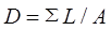
Figure 1 shows the
tidal creek core density map and the statistical map of the tidal creek density
by region in the study area. The tidal creek density in the study area exhibited
a gradual increasing trend, but the rate of increase gradually slowed down. In
Area ??, the tidal
creek density decreased from 0.92 km/km2 in 1998 to 0.56 km/km2
in 2004 after the diversion of the Yellow River, and then, it remained at
0.88–0.93 km/km2 after 2008. The tidal creek density in Area ?? decreased from 0.69 km/km2
in 1998 to 0.56 km/km2 in 2004 and then increased to 0.80 km/km2
in 2008. The rapid expansion period of Spartina
alterniflora occurred from 2008 to 2013. The tidal creek density increased
rapidly from 0.80 km/km2 to 1.17 km/km2 (46.25%). From
2013 to 2018, the distribution of Spartina
alterniflora slowly expanded, and the tidal creek density increased to 1.18
km/km (only 0.85%). The tidal creek density in Area ?? increased each year, from 0.94
km/km2 in 1998 to 1.42 km/km2 in 2008. After the
completion of the reclamation project, i.e., after 2008, the tidal creek
density was in a relatively stable stage, remaining at 1.50–1.65 km/km2
from 2008 to 2018.
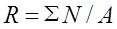
Figure 2 shows a kernel density diagram of
the tidal creek branching points and a statistical diagram of the tidal creek
bifurcation ratio in the study area. In Area ??, owing to the
Figure 1 Kernel density of tidal creek in the
Yellow River Delta National Nature Reserve: (a) 1998, (b) 2004, (c) 2008, (d)
2013, (e) 2018, and (f) statistics of tidal creek density by area
influence
of the diversion of the Yellow River, the bifurcation ratio of the tidal creeks
decreased from 0.32 pieces/km2 in 1998 to 0.17 pieces/km2
in 2004, and it basically remained stable at about 0.3 pieces/km2
after 2008. The bifurcation ratio of the tidal creeks in Area ?? decreased from 0.15 pieces/km2
in 1998 to 0.13 pieces/km2 in 2004. After 2004, with the continuous
development and evolution of the tidal creek system, the bifurcation ratio of
the tidal creeks gradually increased. The abundance of Spartina alterniflora in Area ?? promoted the development of tidal creek branching to a certain
extent[9]. From 2008 to 2013, rapid expansion of Spartina alterniflora occurred, and the
percentage of braided streams increased the most, from 0.32 pieces/km2
to 0.61 pieces/km2 (90.63%). The rapid development of the tidal
creeks in Area ?? and the
wetland restoration increased the bifurcation ratio of the tidal creek from
0.36 pieces/km2 in 1998 to 1.09 pieces/km2 in 2008. After
the wetland restoration, the bifurcation ratio of the tidal creeks gradually increased
and reached a stable state.
Figure 3 shows
the distribution of the average recirculation length of the main tidal creeks
in the study area and a statistical diagram of the average recirculation length
of the main tidal creeks in the different areas. In
Area I, the average length of the tidal creek system increased
Figure 2 Distribution of tidal
creek branch points in the Yellow River Delta National Nature Reserve:
(a) 1998, (b) 2004, (c) 2008, (d) 2013, (e) 2018, and (f) statistics of tidal
creek bifurcation ratio by area
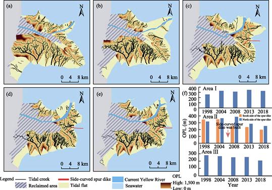
Figure 3 Overmarsh path length of main tidal creek
systems in the Yellow River Delta National Nature Reserve: (a) 1998, (b) 2004,
(c) 2008, (d) 2013, (e) 2018, and (f) statistical chart showing overmarsh path
length (OPL) of the main tidal creek networks annually
from
259.9 m in 1998 to 328.4 m in 2004, and the drainage efficiency decreased.
After the water diversion and sediment regulation experiment, the tidal creeks
developed rapidly, and the average length of the tidal creeks returning to the
channel decreased to 312.1 m in 2008. After 2008, owing to sedimentation in the
new estuary, the area of tidal flat increased, and the average length of the
tidal channel system increased to 347.1 m. After 2013, with the expansion of Spartina alterniflora, the average
return length of the tidal creek system decreased slightly to 326.4 m.
In Area ??, a side bend groin was built in
2006, which resulted in a large difference in the average lengths of the tidal
creeks to the north and south of the groin[9]. After the construction
of the side bend groin in 2006, the average length of the tidal creek system to
the north of the groin increased from 366.3 m in 2004 to 388.1 m in 2008.
However, owing to the rapid expansion of Spartina
alterniflora, the average length of the tidal creek system returned to
283.9 m in 2013. With the continuous development of the tidal creek system and
the continuous expansion of Spartina
alterniflora, the average length of the tidal creek system returned to
251.7 m in 2018. The average length of the tidal creek system to the south of
the groin decreased from 349.8 m in 2004 to 252.1 m in 2008. Since the tidal
flat to the south of the groin was eroded by seawater, the area of the tidal
flat gradually decreased, and the average length of the tidal creek system in
this area also gradually decreased, from 252.1 m in 2008 to 236.7 m in 2013. It
was eventually reduced to 197.5 m in 2018.
In Area ??, after the diversion of the Yellow
River, the original estuary of the Yellow River transitioned from siltation to
erosion, and the wetland restoration project reclaimed the beach surface, which
was located far away from the tidal creeks. Therefore, the average length of
the tidal creek system decreased from 281.3 m in 1998 to 208.9 m in 2018.
4.3 Data Validation
In
the study area, 500 random points were randomly generated, and the land surface
types of the random points were visually interpreted using Google Earth and
SPOT-6 and GF-1 PMS high spatial resolution
satellite images acquired in 1998, 2004, 2008, 2013, and 2018. The overall
extraction accuracy of the tidal creeks was 85%. Due to the low resolution of
the Landsat images, the accurate algorithm for the extraction of the tidal
creek network under a heterogeneous background can extract a limited number of
tidal creeks, so the complete tidal creek data can be obtained after manual
supplementation. In the study area, the accuracy rate of the automatic tidal
creek classification nodes was 92%, and the misclassified nodes had no
influence on the results of the tidal creek classification. No errors were
identified in the results of the tidal creek classification through visual
inspection, and the accuracy rate was 100%.
5 Discussion and Conclusion
In
this study, 20 Landsat TM/OLI satellite images were used to obtain a 30 m
resolution dataset of the distribution of the tidal creek morphological
characteristics in the Yellow River Delta from 1998 to 2018. The results show
that the morphological characteristics of tidal creeks, including the density,
bifurcation ratio, and non-channel path length, exhibited significant spatial-temporal
heterogeneity during the different periods and in the different heterogeneous
environments. The morphological characteristics of the tidal creeks in the
study area were mostly in a moderately stable to stable state, and the growth
rate began to slow down. The diversion of the Yellow River resulted in an increase
in the average return channel length, and the construction of the side bend
groin caused a great difference in the average return channel lengths to the
north and south of the groin. In addition, the rapid expansion of Spartina alterniflora caused a decrease in the average return channel
length. By analyzing the spatial-temporal distribution characteristics of the
tidal creeks in the Yellow River Delta during 1998–2018, we provided a
scientific basis for understanding the evolution mechanism of the tidal creeks
in the Yellow River Delta and for the management of the Yellow River Delta. The results of this study also provide data
support for the national major needs of ecological protection and high-quality
development of the Yellow River Basin.
Author Contributions
Gong, Z. N. created the general design for the development of
the dataset,
conducted the final review of the dataset, and provided suggestions for revising the paper; Qiu, H. C. participated in data
collection; and Mou, K. N. conducted the data processing and wrote the data papers.
Conflicts of Interest
The authors declare no conflicts of
interest.
References
[1]
Mou,
K. N., Gong, Z. N., Qiu, H. C. Spatial-temporal dataset of tidal creek
morphological characteristics in Yellow River Delta (1998–2018) [J/DB/OL]. Digital Journal of Global Change Data
Repository, 2022. https://doi.org/10.3974/geodb.2022.01.09.V1. https://cstr.escience.
org.cn/CSTR:20146.11.2022.01.09.V1.
[2]
GCdataPR Editorial Office.
GCdataPR data sharing policy [OL]. https://doi.org/10.3974/dp.policy.2014.05
(Updated 2017).
[3]
Wang, Q. W., Gong, Z. N., Guan, H. L., et al. Extracting method of tidal creek
features under heterogeneous background at Yellow River Delta using remotely
sensed imagery [J]. Chinese Journal of
Applied Ecology, 2019, 30(9): 3097‒3107.
[4]
Gong, Z.
N., Wang, Q. W., Guan, H. L., et al. Extracting tidal creek features
in a heterogeneous background using Sentinel-2 im-agery: a case study in the
Yellow River Delta, China [J]. International
Journal of Remote Sensing, 2020, 41(10): 3653‒3676.
[5]
Marani, M., Belluco, E.,
D??Alpaos, A., et al. On the drainage density of tidal
networks [J]. Water Resources Research,
2003, 39(2): 1040.
[6]
Horton, R.
E., Htrata, T. Erosional development of streams
and their drainage basins, hydrophyrical approach to quan-titative morphology
[J]. Journal of the Japanese Forest
Society, 1955, 37(6): 257‒262.
[7]
Lohani, B., Mason, D. C.,
Scott,
T. R., et al. Extraction of tidal channel
networks from aerial photographs alone and com-bined with laser altimetry [J]. International Journal of Remote Sensing,
2006, 27(1): 5‒25.
[8]
Chirol, C., Haigh, I. D.,
Pontee,
N., et al. Parametrizing tidal creek morphology in mature saltmarshes
using semi-automated extraction from lidar [J]. Remote Sensing of Environment, 2018, 209: 291‒311.
[9]
Mou,
K. N., Gong,
Z. N., Qiu,
H. C. Spatiotemporal differentiation and development process of tidal creek network
morphological characteristics in Yellow River Delta [J]. Acta Geographica Sinica, 2021, 76(9): 2312‒2328.